Descripción:
1851. London & New York, J & F. Tallis, 1851. Original steel engraving / Vintage map. Drawn and engraved by John Rapkin. Partly hand-coloured. Size of the actual map: 27 cm x 37 cm. Very good condition. John Tallis (7 November 1817 3 June 1876) was an English cartographic publisher. His company, John Tallis and Company, published views, maps and atlases in London from roughly 1838 to 1851. Tallis set up as a publisher with Frederick Tallis in Cripplegate in 1842; the business moved to Smithfield in 1846, and was dissolved in 1849. From 1851 to 1854 Tallis operated as John Tallis and Company. He started The illustrated news of the world and national portrait gallery of eminent personages in 1858, selling it for £1,370 in 1861; it folded in 1863. (Wikipedia) The most important project John Tallis undertook, was the 'Illustrated Atlas' from 1851. The original map we offer here, was part of this exceptional Atlas and all the maps it contained are still today considered as the last reminder of an era…
Leer más Resultados de búsqueda: Graphics and Art from Inanna Rare Books Ltd.
Has buscado:
- Librería: Inanna Rare Books Ltd.
- Tema: Graphics and Art from Inanna Rare Books Ltd.
Resultados: 21 - 40 de 310

Más fotos
Australia with beautiful Vignettes and illustrations of Natives of the Tribe of Bogan, Sydney, Kangaroos, Australian Parrots and Cockatoo, Natives of Australia Felix. The beautiful map shows the whole continent of Australia with Van Diemen's Island (Tasmania). The map lists all the counties in Victoria, New South Wales, South Australia, West Australia.
de Tallis, John / Rapkin, John. (1817 - 1876)
- Usado
- Estado
- Usado
- Cantidad disponible
- 1
- Librería
-
Skibbereen, Ireland
- Precio
-
EUR 380.00EUR 39.00 enviando a USA
Mostrar detalles
Precio
EUR 380.00
EUR 39.00
enviando a USA
Más fotos
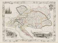
Austria - With Vignettes of Vienna, Return of the Sennerin, and St. Stephen's, Vienna.
de Austria - Tallis, John / Rapkin, John. (1817 - 1876)
- Usado
- Estado
- Usado
- Cantidad disponible
- 1
- Librería
-
Skibbereen, Ireland
- Precio
-
EUR 175.00EUR 39.00 enviando a USA
Mostrar detalles
Descripción:
1851. London, Edinburgh & Dublin, J & F. Tallis, 1851. Original steel engraving / Vintage map. Drawn and engraved by John Rapkin. Partly hand-coloured. Illustrations by H. Warren and Engraved by J.H. Kernot. Plate Size: 33 cm x 25.5 cm. Sheet Size: 37.5 cm x 27.2 cm. Vintage 19th century map in very good condition. Beautiful map of Austria with gorgeous illustrated vignettes from the Victorian publisher. This is the Austria of the Hapsburgs and the political sub-divisions show the polyglot nature of this multi-national domain. Renowned cities such as Milan, Prague, Buda and Pest, and ancient regions such as Lombardy, Tyrol, Illyria, Carinthia, Salzburg, Istria, Bohemia, Moravia, Croatia, Dalmatia, Sclavonia, Hungary, Banat, Transylvania, Bukovina and Gallicia show the extent of Vienna's empire. Prussia and Russia border her to the east after the three powers consumed Poland in the past century. Ottoman Turkey is still supreme in the Balkans for the time being. To the West lie Switzerland and the…
Leer más Precio
EUR 175.00
EUR 39.00
enviando a USA

Más fotos
BAHVSIA Arx Norwegiae Regi Suecia CAROLO GUSTAVO ex pactis Rodschildensibus traetin enandem .../ Die 30. Martij 1658.
de Bohus / Sweden - [Pufendorf, Samuel von] Dahlberg, Erik / Perelle, A. / (1632 - 1694)
- Usado
- Estado
- Usado
- Cantidad disponible
- 1
- Librería
-
Skibbereen, Ireland
- Precio
-
EUR 380.00EUR 39.00 enviando a USA
Mostrar detalles
Descripción:
1696. Nuremberg, Christoph Riegel, 1696. Original copper engraving from Pufendorf's "De rebus a Carolo Gustavo", this being Plate No.80 with an inset map of the border-region between Sweden and Norway at the end of the 17th century. Beautifully Framed. Size of frame with the copper engraving: 54.5 cm x 45.5 cm. Size of the actual engraving: c. 44 cm x 35.5 cm. Excellent condition. Bohus Fortress (also known as Baahus or Båhus, originally: Bágahús) lies along the old NorwegianSwedish border in Kungälv, Bohuslän, Sweden, north east from Hisingen where the Göta river splits into two branches (20 km (12 mi) north of Gothenburg). It commands the surrounding area from a cliff 40 m (130 ft) high, with the river forming a natural moat around it. The fortress was attacked or besieged 14 times, but was never captured. During the Northern Seven Years' War, in 15631570, it was seriously damaged. This occurred in 1566, when 250 Swedish soldiers successfully stormed the northeastern-most tower. The…
Leer más Precio
EUR 380.00
EUR 39.00
enviando a USA

Ball in a Mountain Stream I".
de Wilson, Jim. (*1943)
- Usado
- Estado
- Usado
- Cantidad disponible
- 1
- Librería
-
Skibbereen, Ireland
- Precio
-
EUR 1,280.00EUR 39.00 enviando a USA
Mostrar detalles
Descripción:
2008. Ireland, 2008. Original Ink Drawing on laid paper. 38 x 56,2 cm. Signed and dated. [Price includes 13,5% VAT (214,10) Net 1585,90 ]
Precio
EUR 1,280.00
EUR 39.00
enviando a USA

Más fotos
Bank of Ireland, Dublin (South Portico) - "The Original Parliament House".
de Winkles, B. [Engraver] / Petrie, George [Artist / After a Drawing by George Petrie]
- Usado
- Estado
- Usado
- Cantidad disponible
- 1
- Librería
-
Skibbereen, Ireland
- Precio
-
EUR 175.00EUR 39.00 enviando a USA
Mostrar detalles
Descripción:
1829. London, Charles Tilt in Fleet Street, [1829]. Original, 19th century Steel Engraving. 23 cm x 18 cm. Very good condition.
Precio
EUR 175.00
EUR 39.00
enviando a USA

Más fotos
Bartholomew Close" / Old London.
de George, Sir Ernest. (1839-1922)
- Usado
- Estado
- Usado
- Cantidad disponible
- 1
- Librería
-
Skibbereen, Ireland
- Precio
-
EUR 195.00EUR 39.00 enviando a USA
Mostrar detalles
Descripción:
1884. London, The Fine Art Society, 1884. Original Etching. 26 cm x 37 cm. Original, vintage etching by Sir Ernest George. Signed in the plate, not in pencil ! Only very faint signs of some foxing. Mounted, ready to be framed. With descriptive Letterpress by Ernest George (included is a wonderful historic explanation regarding this old location in London by Ernest George). Sir Ernest George RA (13 Jun 18391922) was an English architect, landscape and architectural watercolour painter, and etcher. His London office was once called "The Eton of architects' offices". His pupils included Herbert Baker, Guy Dawber, John Bradshaw Gass, Edwin Lutyens and Ethel Charles. In the 1870s in partnership with Harold Peto, George designed houses in London for the Cadogan Estate in Chelsea and Kensington, and a number of country houses. In 1881 they designed Stoodleigh Court at Tiverton for Thomas Carew. In 1891 they designed an extension to West Dean House for William James, creating the Oak Room, now Oak Hall in…
Leer más Precio
EUR 195.00
EUR 39.00
enviando a USA

Más fotos
Bath - with Vignettes and illustrations of Royal Crescent, St.Michael's Church, Abbey Church. With Great Western Railway line to Bristol and Exeter and London. Beautiful birds-eye view on roads and parks and the River Avon.
de Tallis, John / Rapkin, John. (1817 - 1876)
- Usado
- Estado
- Usado
- Cantidad disponible
- 1
- Librería
-
Skibbereen, Ireland
- Precio
-
EUR 480.00EUR 39.00 enviando a USA
Mostrar detalles
Descripción:
1851. London & New York, J & F. Tallis, 1851. Original steel engraving / Vintage map. Drawn and engraved by John Rapkin. Beautifully Framed. Size of frame with map: 51 cm x 41.5 cm. Size of the actual map: 27 cm x 37 cm. Very good condition. John Tallis (7 November 1817 3 June 1876) was an English cartographic publisher. His company, John Tallis and Company, published views, maps and atlases in London from roughly 1838 to 1851. Tallis set up as a publisher with Frederick Tallis in Cripplegate in 1842; the business moved to Smithfield in 1846, and was dissolved in 1849. From 1851 to 1854 Tallis operated as John Tallis and Company. He started The illustrated news of the world and national portrait gallery of eminent personages in 1858, selling it for £1,370 in 1861; it folded in 1863. (Wikipedia) The most important project John Tallis undertook, was the 'Illustrated Atlas' from 1851. The original map we offer here, was part of this exceptional Atlas and all the maps it contained are still today…
Leer más Precio
EUR 480.00
EUR 39.00
enviando a USA

Beara Hills / Caha Mountains with Hungry Hill and Sugarloaf.
de Street, Evelyn
- Usado
- Estado
- Usado
- Cantidad disponible
- 1
- Librería
-
Skibbereen, Ireland
- Precio
-
EUR 6,800.00EUR 39.00 enviando a USA
Mostrar detalles
Descripción:
1971. Bantry (West Cork), 1971. Oil on Canvas. Framed: 159 cm wide x 129 cm high. Canvas: 152 cm wide x 122 cm high. Unusually excellent condition of this striking XXL - Painting with only minor signs of wear. Signed and dated verso by Evelyn Street in June, 1971. Provenance: Naylor Collection. Price includes boxed shipping worldwide per Courier. The painting is now beautifully framed. [Price includes 13.5% VAT (808,81) - Net: 5991,19 ] Evelyn Street trained at the Cork School of Art in the 1950s, later moving to England where she taught at the South Devon School of Art. She is best known for her semi-abstract paintings which refer to geological strata and natural forms and which she exhibited in numerous solo exhibitions in London during the 1960s. (Source: "Askart") Evelyn Street lived in Bantry, West Cork, where she took in the countryside and painted the stunning surroundings in her very own geological style of capturing the landscape in a naive but striking manner. This is one of three…
Leer más Precio
EUR 6,800.00
EUR 39.00
enviando a USA
![Bedelaar [Bettler / Beggar].](https://d3525k1ryd2155.cloudfront.net/h/318/075/1465075318.0.m.jpg)
Más fotos
Bedelaar" ["Bettler" / "Beggar"].
de Aarts, Johannes Josephus (1871 - 1934)
- Usado
- Estado
- Usado
- Cantidad disponible
- 1
- Librería
-
Skibbereen, Ireland
- Precio
-
EUR 1,400.00EUR 39.00 enviando a USA
Mostrar detalles
Descripción:
1903. [Amsterdam], Roeloffzen, Hübner und van Santen, 1903. Rare, antique, vintage, original Lithograph by the dutch artist Johannes Josephus Aarts, showing the scene of an invalid beggar entering a Hamlet of farmers and asking for alms. Striking and beautiful scene in the typical earthy, nature-embedded, strong depiction by Aarts; full of character and gripping through the magnified presence of Aarts subjects, which are "in your face". Signed in pencil by Johannes Josephus Aarts. [Fine Art-Paper watermarked "TRCHES"]. Size of the framed Picture: 63 cm wide x 53 cm high. Size of the Sheet : 49 cm wide x 41 cm high (the image itself: 22 cm x 30 cm). Excellent condition, beautifully framed. The price for this signed and rare lithograph includes free international courier shipping per UPS Express. Johannes Josephus Aarts (18 August 1871, in The Hague 19 October 1934, in Amsterdam) was a Dutch painter, illustrator, lithographer, engraver, etcher, writer, academic teacher and director, lecturer,…
Leer más Precio
EUR 1,400.00
EUR 39.00
enviando a USA

Más fotos
Belgii pars Septentrionalis Communi Nomine Vulgo Hollandia Nuncupata Continens Statum Potentissimae Batavorum Reipublicae seu Provincias VII Foederatas.
de Holland - Schenk, Petrus. (1660-1711)
- Usado
- Estado
- Usado
- Cantidad disponible
- 1
- Librería
-
Skibbereen, Ireland
- Precio
-
EUR 750.00EUR 39.00 enviando a USA
Mostrar detalles
Descripción:
1700. Amsterdam, Schenk, [c.1700]. Original hand-coloured engraving. Plate Size: 58 cm x 46.5 cm. Sheet Size: 60.2 cm x 51.7 cm. Original map. In good- condition. Browning evident as is a tear near lower centre fold. Some inked underlining to place names. Minor inked numeration in margin at top right corner. Slight crease on verso sheet. Discreet duplicate stamp from library in Poland on reverse. A highly detailed and very interesting map of Holland and its former and current foreign holdings included in inset boxes. The individual provinces Dutch Republic are clearly demarcated. Rivers and hills and forests and marshes are shown pictorially - as are the shallow approaches and sandbanks along the coast. Towns and cities such as Amsterdam, are also included, and many depicted pictorially also. An inset box in the lower right corner shows the most southernly province, Limburg. In the lower left is Flanders while the regions comprising modern-day Luxemburg and Germany fill out the map. A stunning…
Leer más Precio
EUR 750.00
EUR 39.00
enviando a USA
Más fotos
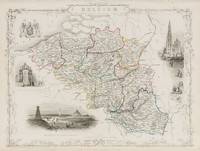
Belgium - with Vignettes of Antwerp Cathedral, Monuments on the Plains of Waterloo and the Altar of St Gudule, Brussels.
de Belgium - Tallis, John / Rapkin, John. (1817 - 1876)
- Usado
- Estado
- Usado
- Cantidad disponible
- 1
- Librería
-
Skibbereen, Ireland
- Precio
-
EUR 375.00EUR 39.00 enviando a USA
Mostrar detalles
Descripción:
1851. London, Edinburgh & Dublin, J & F. Tallis, 1851. Original steel engraving / Vintage map. Drawn and engraved by John Rapkin. Partly hand-coloured. Illustrations by J. Marchant and engravings by J.B. Allen. Plate Size: 34 cm x 26.3 cm. Sheet Size: 27.1 cm x 37.5 cm. Vintage 19th century map in very good condition. Published in the Illustrated Atlas, And Modern History Of The World Geographical, Political, Commercial & Statistical, Edited By R. Montgomery Martin. Beautiful and interesting map of Belgium from the Victorian Era. The political sub-divisions are shown on the map, with provinces such as West Flanders, Limburg and the Grand Duchy of Luxembourg included. The North Sea, France, Prussia and Holland all conspire to surround Belgium. The canal and railway systems are included on the map, linking famous and historic cities such as Bruges and Ghent. The map is crowded with the names of towns and cities, highlighting the population density of this much fought over part of the continent -…
Leer más Precio
EUR 375.00
EUR 39.00
enviando a USA
Más fotos
Birmingham - With Vignettes of the London & North Western Railway Station, St Philip's Church, Theatre Royal, Birmingham from Highgate, King Edward's School, Bull Ring, School of Design, and Town Hall.
de England - Tallis, John / Rapkin, John. (1817 - 1876)
- Usado
- Estado
- Usado
- Cantidad disponible
- 1
- Librería
-
Skibbereen, Ireland
- Precio
-
EUR 375.00EUR 39.00 enviando a USA
Mostrar detalles
Descripción:
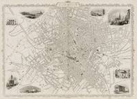
1851. London & New York, The London Printing and Publishing Company, 1851. Original steel engraving / Vintage map. Drawn and engraved by John Rapkin. Illustrated and Engraved by D. Pound. Plate Size: 49 cm x 36.5 cm. Sheet Size: 51.5 cm x 37.2 cm. Vintage 19th century map / city-plan in very good condition. Published in the Illustrated Atlas, And Modern History Of The World Geographical, Political, Commercial & Statistical, Edited By R. Montgomery Martin. Handsome town-plan of Manchester in the North West of England. The River Irwell can be seen running through the city. Canals railways, street and district areas of the city are also included. Decorative scrolling and title cartouche around the edges of the map. One of the few double page plans published by Tallis. The project of 'The Illustrated Atlas' was designed to be finished just in time for the anxiously awaited "Great Exhibition of the Works of Industry of All Nations" or The Great Exhibition, sometimes referred to as the Crystal Palace…
Leer más Precio
EUR 375.00
EUR 39.00
enviando a USA
![Blaawberg Strand [Bloubergstrand] (with shipwreck) and Hermanus.](https://d3525k1ryd2155.cloudfront.net/h/754/369/1268369754.0.m.jpg)
Más fotos
Blaawberg Strand [Bloubergstrand] (with shipwreck) and Hermanus.
de Pemberton, H.M. [Hilda Mary]. (1871 - 1957)
- Usado
- Estado
- Usado
- Cantidad disponible
- 1
- Librería
-
Skibbereen, Ireland
- Precio
-
EUR 350.00EUR 39.00 enviando a USA
Mostrar detalles
Descripción:
1915. [South Africa], no year [c. 1915]. Two original etchings, signed and titled in pencil. Beautifully framed. The frames with the etchings measure: 39 cm x 34.5 cm. The etchings themselves measure: c. 26 cm x 24 cm. Excellent condition but with some foxing. Frames with minimal signs of wear.
Precio
EUR 350.00
EUR 39.00
enviando a USA

Más fotos
Blackbird Bower II".
de Wilson, Jim. (*1943)
- Usado
- Estado
- Usado
- Cantidad disponible
- 1
- Librería
-
Skibbereen, Ireland
- Precio
-
EUR 4,800.00EUR 39.00 enviando a USA
Mostrar detalles
Descripción:
2015. Ireland, 2015. Original Ink Drawing on laid paper. Framed measurements: 71 cm wide x 65,5 cm high. Artwork (sheet): 56 cm wide x 56 cm high. Signed and dated. Beautifully framed. [Includes 13,5% VAT (570,93) Net 4229,07 ] Jim Wilson's art at its best: playful ornament, labyrinths of decorative patterns, floral elements and patient endurance which lets us marvel at the result ! Did you find the Blackbird ? And the Rabbit ?
Precio
EUR 4,800.00
EUR 39.00
enviando a USA

Más fotos
Blast ! Crash".
de Wilson, Jim. (*1943)
- Usado
- Estado
- Usado
- Cantidad disponible
- 1
- Librería
-
Skibbereen, Ireland
- Precio
-
EUR 900.00EUR 39.00 enviando a USA
Mostrar detalles
Descripción:
2008. Ireland, 2008. Original Ink Drawing on laid paper. 54 x 54 cm. Signed and dated. [Price includes 13,5% VAT (107,05) Net 792.95 ]
Precio
EUR 900.00
EUR 39.00
enviando a USA

Más fotos
Blasted".
de Wilson, Jim. (*1943)
- Usado
- Estado
- Usado
- Cantidad disponible
- 1
- Librería
-
Skibbereen, Ireland
- Precio
-
EUR 600.00EUR 39.00 enviando a USA
Mostrar detalles
Descripción:
2008. Ireland, 2008. Original Ink Drawing on laid paper. 44,5 x 45 cm. Signed and dated. [Price includes 13,5% VAT (71,37) Net 528,63 ]
Precio
EUR 600.00
EUR 39.00
enviando a USA

Más fotos
Bookmark "April" - Designed by Walter Crane for the Scottish Widows' Fund in the "Bonus Year 1913".
de Crane, Walter
- Usado
- Estado
- Usado
- Cantidad disponible
- 1
- Librería
-
Skibbereen, Ireland
- Precio
-
EUR 95.00EUR 39.00 enviando a USA
Mostrar detalles
Descripción:
1913. [London], Scottish Widows Fund / Mutual Life Assurance Society, 1913. Original Lithographed Bookmark. 6 cm wide x 15,5 cm high. Slightly creased but complete and not torn. Walter Crane (15 August 1845 14 March 1915) was an English artist and book illustrator. He is considered to be the most influential, and among the most prolific, children's book creators of his generation and, along with Randolph Caldecott and Kate Greenaway, one of the strongest contributors to the child's nursery motif that the genre of English children's illustrated literature would exhibit in its developmental stages in the later 19th century. Crane's work featured some of the more colourful and detailed beginnings of the child-in-the-garden motifs that would characterize many nursery rhymes and children's stories for decades to come. He was part of the Arts and Crafts movement and produced an array of paintings, illustrations, children's books, ceramic tiles, wallpapers and other decorative arts. Crane is also…
Leer más Precio
EUR 95.00
EUR 39.00
enviando a USA

Más fotos
Boston - With Beautiful Vignettes of Boston, the State House and Bunker Hill's Monument.
de United States - Tallis, John / Rapkin, John. (1817 - 1876)
- Usado
- Estado
- Usado
- Cantidad disponible
- 1
- Librería
-
Skibbereen, Ireland
- Precio
-
EUR 450.00EUR 39.00 enviando a USA
Mostrar detalles
Descripción:
1851. London & New York, John Tallis & Company, 1851. Original steel engraving / Vintage map. Drawn and engraved by John Rapkin. Illustrated and Engraved by J. Watkins Plate Size: 32.5 cm x 26 cm. Sheet Size: 37.2 cm x 27.2 cm. Vintage 19th century map in very good condition. Published in the Illustrated Atlas, And Modern History Of The World Geographical, Political, Commercial & Statistical, Edited By R. Montgomery Martin. Handsome town-plan of Boston, Massachusetts. The Charles River can be seen running between Boston and Charlestown. South Boston and East Boston are also included within Boston Harbour. Parts of Cambridge are also visible. The map covers downtown Boston prior to the Back Bay landfill projects, extending from Dover Street to the Charles River. Railway, street and district areas of the city are also included. Decorative scrolling and title cartouche around the edges of the map. The project of 'The Illustrated Atlas' was designed to be finished just in time for the anxiously awaited…
Leer más Precio
EUR 450.00
EUR 39.00
enviando a USA

Más fotos
Brazil - with Vignettes and Illustrations of Boats on the Rio Negro / St.Catharina / Monte Video / Cape St. Antonio in Bahia / Rio de Janeiro.
de America / South America / Latin America / Brazil - Tallis, John / Rapkin, John. (1817 - 1876)
- Usado
- Estado
- Usado
- Cantidad disponible
- 1
- Librería
-
Skibbereen, Ireland
- Precio
-
EUR 350.00EUR 39.00 enviando a USA
Mostrar detalles
Descripción:
1851. London & New York, J & F. Tallis, 1851. Original steel engraving / Vintage map. Drawn and engraved by John Rapkin. Partly hand-coloured. Plate Size: 23.9 cm x 34.3 cm. Sheet Size: 27.5 cm x 37.4 cm. Vintage 19th century map in very good condition. John Tallis (7 November 1817 3 June 1876) was an English cartographic publisher. His company, John Tallis and Company, published views, maps and atlases in London from roughly 1838 to 1851. Tallis set up as a publisher with Frederick Tallis in Cripplegate in 1842; the business moved to Smithfield in 1846, and was dissolved in 1849. From 1851 to 1854 Tallis operated as John Tallis and Company. He started The illustrated news of the world and national portrait gallery of eminent personages in 1858, selling it for £1,370 in 1861; it folded in 1863. (Wikipedia) The most important project John Tallis undertook, was the 'Illustrated Atlas' from 1851. The original map we offer here, was part of this exceptional Atlas and all the maps it contained are…
Leer más Precio
EUR 350.00
EUR 39.00
enviando a USA

Más fotos
Brighton - With Beautiful Vignettes of the Chain Pier, Railway Station, and the Old Steyne and the Pavillion.
de Britain - Tallis, John / Rapkin, John. (1817 - 1876)
- Usado
- Estado
- Usado
- Cantidad disponible
- 1
- Librería
-
Skibbereen, Ireland
- Precio
-
EUR 375.00EUR 39.00 enviando a USA
Mostrar detalles
Descripción:
1851. London & New York, John Tallis & Company, 1851. Original steel engraving / Vintage map. Drawn and engraved by John Rapkin. Illustrated and Engraved by H. Bibby. Plate Size: 34cm x 25.5 cm. Sheet Size: 37.3 cm x 27 cm. Vintage 19th century map in very good condition. Published in the Illustrated Atlas, And Modern History Of The World Geographical, Political, Commercial & Statistical, Edited By R. Montgomery Martin. Handsome town-plan of Brighton, in East Sussex, England. It's coastal location and relative proximity to London, helped to develop it into a popular seaside resort in the 19th Century. Railway, street and district areas of the city are also included. Decorative scrolling and title cartouche around the edges of the map. The project of 'The Illustrated Atlas' was designed to be finished just in time for the anxiously awaited "Great Exhibition of the Works of Industry of All Nations" or The Great Exhibition, sometimes referred to as the Crystal Palace Exhibition in reference to the…
Leer más Precio
EUR 375.00
EUR 39.00
enviando a USA

¿No has encontrado lo que estabas buscando?
Prueba a añadir esta búsqueda a búsquedas guardadas Cada día se añaden millones de libros a Biblio. Cuando uno de ellos encaje con tu búsqueda, te enviaremos un correo para avisarte. Y lo mejor de todo, ¡es gratis!
Añadir a búsquedas guardadas

¿Eres un lector habitual o un coleccionista de libros?
Únete al Biblioclub y ahorra 10% en cada compra, ¡cada día! Hasta un máximo de 20$ en cada pedido

Responsabilidad social
¿Sabías que desde 2004 Biblio ha destinado sus beneficios a la construcción de 16 bibliotecas públicas en zonas rurales de Latinoamérica?
