Descripción:
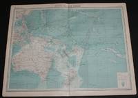
The Times, London, 1920. First Edition. Softcover. Very Good Condition/No Dust Jacket. Disbound single sheet with vertical centre fold from the 1920 "The Times Survey Atlas of the World". Map is in colour and sheet is suitable for framing. Land is coloured grey and sea is shades of blue according to depth. Map contains major currents/streams and directions are indicated by small arrows. Key shipping routes are marked. Mapped area includes; South Pacific Ocean, North and South Equatorial Currents, Equatorial Counter Current, Micronesia, Melanesia and Oceania, Australia, Tasmania, Hawaii, Papua New Guinea, Philippines, New Zealand, Fiji, Tonga, New Hebrides, Caroline Islands, East Indian Archipelago, Marquesas Islands, Chatham Island, Tuamotu or Low Archipelago, Lin Kin Islands, Magelhaes Archipelago, Soloman Islands, Bismark Archipelago, etc. Sheet has slightly darkened edges with occasional light foxing in the margins and edges of the mapped area. Sheet is otherwise clean and bright.…
Leer más Resultados de búsqueda: pacific ocean atlas plate
Has buscado:
- Título: pacific ocean atlas plate
Resultados: 1 - 1 de 1
Más fotos
Map of South Pacific Ocean from the 1920 Times Atlas (Plate 102) including Australia, Hawaii, Papua New Guinea, Philippines, New Zealand, Fiji, Tonga, New Hebrides, Caroline Islands, East Indian Archipelago, Marquesas Islands, etc
de The Times and J. G. Bartholomew
- Usado
- Tapa blanda
- First
- Estado
- Usado - Very Good Condition
- Edición
- First Edition
- Encuadernación
- Paperback
- Cantidad disponible
- 1
- Librería
-
Doncaster, Aberdeen, United Kingdom
- Precio
-
EUR 28.51EUR 17.23 enviando a USA
Mostrar detalles
Precio
EUR 28.51
EUR 17.23
enviando a USA

¿No has encontrado lo que estabas buscando?
Prueba a añadir esta búsqueda a búsquedas guardadas Cada día se añaden millones de libros a Biblio. Cuando uno de ellos encaje con tu búsqueda, te enviaremos un correo para avisarte. Y lo mejor de todo, ¡es gratis!
Añadir a búsquedas guardadas

¿Eres un lector habitual o un coleccionista de libros?
Únete al Biblioclub y ahorra 10% en cada compra, ¡cada día! Hasta un máximo de 20$ en cada pedido

Responsabilidad social
¿Sabías que desde 2004 Biblio ha destinado sus beneficios a la construcción de 16 bibliotecas públicas en zonas rurales de Latinoamérica?
