Descripción:
Base Printing Plant, 29th Engineers, U.S. Army, 1918. Large, linen-backed folding map of Koblenz, Germany and vicinity. World War I era. Based on a "Prussian Map, Issue of 1886... corrected to Jan. 1, 1919." The map unfolds to 29" tall by 34" wide. Moderate soil to extremities of the blank (linen) side else Very Good condition. "Copyright edition" [4th Tauchnitz ed.]. Hardcover. Very Good condition.
Resultados de búsqueda: Maps / Cartography from About Books
Has buscado:
- Librería: About Books
- Tema: Maps / Cartography from About Books
Resultados: 21 - 40 de 152

Coblenz [World War I era Map of Koblenz, Germany]
de American Expeditionary Forces, US Army
- Usado
- Tapa dura
- Estado
- Usado - Very Good condition
- Edición
- "Copyright edition" [4th Tauchnitz ed.]
- Encuadernación
- Hardcover
- Cantidad disponible
- 1
- Librería
-
Henderson, Nevada, United States
- Precio
-
EUR 46.59EUR 6.06 enviando a USA
Mostrar detalles
Precio
EUR 46.59
EUR 6.06
enviando a USA
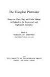
Foto de archivo: la portada puede ser diferente
The Compleat Plattmaker : Essays on Chart, Map, and Globe Making in England in the Seventeenth and Eighteenth Centuries
de Thrower, Norman J. W.
- Usado
- Tapa dura
- First
- Estado
- Usado - Fine condition
- Edición
- First Edition
- Encuadernación
- Hardcover
- ISBN 10 / ISBN 13
- 9780520035225 / 0520035224
- Cantidad disponible
- 1
- Librería
-
Henderson, Nevada, United States
- Precio
-
EUR 16.18EUR 6.06 enviando a USA
Mostrar detalles
Descripción:
Berkeley, Los Angeles, London: University of California Press, 1978. NOT a library discard. Fine condition. Bright, clean, square and tight. Sharp corners. NO owner's name or bookplate. NO remainder mark. Fresh and crisp - probably never read. NO underlining. NO highlighting. NO margin notes. Contains a preface and 6 cartographical essays -- by Helen M. Wallis; Thomas R. Smith; Jeannette D. Black; Coolie Verner; David A. Woodward; and Norman J. W. Thrower. Illustrated. Index. Bound in the original gold cloth, stamped in blue.. First Edition. Hardcover. Fine condition/No jacket, probably as issued. 8vo. xvii, 241pp. Great Packaging, Fast Shipping.
Precio
EUR 16.18
EUR 6.06
enviando a USA
The Complete City Maps of Michigan (hardcover edition)
de Citmap Corporation (Russell Madsen, publisher)
- Usado
- Tapa dura
- First
- Estado
- Usado - Very Good condition
- Edición
- 1st ed? (No additional printings listed)
- Encuadernación
- Hardcover
- Cantidad disponible
- 1
- Librería
-
Henderson, Nevada, United States
- Precio
-
EUR 36.33EUR 6.06 enviando a USA
Mostrar detalles
Descripción:
Wyoming, Michigan: Citmap Corporation Scarce Hardcover edition. Very Good condition. Bound in the original blue boards, stamped in white, red and black. Covers only lightly rubbed. Inner hinges are perfect. Bright, clean, square, and tight. Corners are NOT bumped. NO owner's name or bookplate. NO remainder mark. Pages are clean and crisp. NO underlining. NO highlighting. NO margin notes. Oversize Hardcover. 8.75" wide by 11.25" tall. From publisher's promo sheet laid-in: "Accurate, readable maps for all cities over 1000 pop. with street indexes.". 1st ed? (No additional printings listed). Oversize Hardcover. Very Good condition/No jacket, probably as issued. 527pp.
Precio
EUR 36.33
EUR 6.06
enviando a USA
Copy of a Letter of the King of Portugal Sent to the King of Castile Concerning the Voyage and Success of India
de Pacifici, Sergio J.
- Usado
- Tapa dura
- First
- Estado
- Usado - Fine condition
- Edición
- First Edition, Limited to 1000 copies
- Encuadernación
- Hardcover
- Cantidad disponible
- 1
- Librería
-
Henderson, Nevada, United States
- Precio
-
EUR 13.94EUR 6.06 enviando a USA
Mostrar detalles
Descripción:
Minneapolis: University of Minnesota Press, 1955. Fine condition in a Fine clear plastic dust jacket. NO chips. NO tears. NO creases. Bright, clean, square and tight. Sharp corners. Hinges are perfect. Previous owner's bookplate on pastedown endpaper. NOT a library discard. Pages are fresh and crisp. A translation of the 1505 first edition concerning Portuguese voyages to the East to buy spices. Also contains the first printed reference to the discovery of Brazil. Illustrated. Translated by Sergio J. Pacifici. A publication from the James Ford Bell Collection in the University of Minnesota Library. Limited to 1000 numbered copies; this being #408. Map endpapers. Two-tone binding (decorated blue paper covered boards with a pale yellow cloth spine printed in blue). Complete with clear plastic dust jacket.. First Edition, Limited to 1000 copies. Hardcover. Fine condition/Fine dust jacket. 8vo. (viii), 27pp. Great Packaging, Fast Shipping.
Precio
EUR 13.94
EUR 6.06
enviando a USA
Decorative Printed Maps of the 15th to 18th Centuries
de Skelton, R. A.
- Usado
- Tapa dura
- First
- Estado
- Usado - Near Fine condition
- Edición
- First Edition Thus
- Encuadernación
- Hardcover
- Cantidad disponible
- 1
- Librería
-
Henderson, Nevada, United States
- Precio
-
EUR 27.93EUR 6.06 enviando a USA
Mostrar detalles
Descripción:
London: Staples Press, 1952. Near Fine condition in a Fair dust jacket (rubbing, chips, tears). Protected by a removable Brodart clear-plastic sleeve. NOT a library discard. NO owner's name or bookplate. Pages are clean, crisp and unmarked. First Edition Thus. Many collectors prefer the large format (9.75" wide by 12.5" tall) of this 1952 first impression over the smaller size of later printings. "First published 1952" is so stated. This is a revised and enlarged edition of OLD DECORATIVE MAPS AND CHARTS by A. L. Humphreys (1926). This 1952 edition adds 22 plates. The text by R. A. Skelton, Superintendent of the British Museum's Map Room, is entirely new, and a major improvement in terms of sophistication, precision and detail. 87 pages of text + 84 map reproductions on coated stock. Twelve maps in beautiful full color. Bound in the original gilt-stamped maroon cloth. From the dust jacket: "DECORATIVE PRINTED MAPS provides a survey of maps printed from…
Leer más Precio
EUR 27.93
EUR 6.06
enviando a USA
The Delights of a Rare Book Librarian
de Goff, Frederick R.
- Usado
- Tapa blanda
- First
- Estado
- Usado - Very Fine condition
- Edición
- First Edition, Limited 1,000 copies
- Encuadernación
- Paperback
- Cantidad disponible
- 1
- Librería
-
Henderson, Nevada, United States
- Precio
-
EUR 18.61EUR 6.06 enviando a USA
Mostrar detalles
Descripción:
Boston Public Library, 1975. A beautiful, unusually bright copy. Very Fine condition. NO rubbing. NO fading. Fresh, crisp, clean - apparently never read. 1975. First Edition. Limited to 1,000 copies. Illustrated with title page and map reproductions. Goff discusses Incunabula in the Library of Congress, maps of Washington DC, Jefferson's books, etc. Maury A. Bromsen Lecture in Humanistic Bibliography, No. 2. Designed by The Stinehour Press. Bound in the original off white wraps, decorated in blue.. First Edition, Limited 1,000 copies. Softcover. Very Fine condition. 36pp. Great Packaging, Fast Shipping.
Precio
EUR 18.61
EUR 6.06
enviando a USA
![The Early Cartography of the Pacific [new, in publisher's shrinkwrap]](https://d3525k1ryd2155.cloudfront.net/f/625/981/9781578981625.OL.0.m.jpg)
Foto de archivo: la portada puede ser diferente
The Early Cartography of the Pacific [new, in publisher's shrinkwrap]
de Wroth, Lawrence C.
- Nuevo
- Tapa dura
- Estado
- Nuevo
- Edición
- 1999 reprint of the 1944 original
- Encuadernación
- Hardcover
- ISBN 10 / ISBN 13
- 9781578981625 / 157898162X
- Cantidad disponible
- 1
- Librería
-
Henderson, Nevada, United States
- Precio
-
EUR 65.24EUR 6.06 enviando a USA
Mostrar detalles
Descripción:
Mansfield Centre, Connecticut: Martino Publishing, 1999. Brand New HARDCOVER in perfect condition. STILL SEALED in the publisher's clear plastic SHRINKWRAP. NO rubbing. NO fading. Bright, clean, square and tight. Sharp corners. NO owner's name or bookplate. NOT a remainder. Fresh and crisp -- obviously never read. 1999 reprint of the 1944 original. A standard work. Illustrated with 22 FOLD-OUT maps. "[A]n excellent study of those maps from Ptolemy to 1798 important in the development of the cartography of the Pacific area, with facsimiles of 22 of the 104 maps described." -- Ristow 393 (in GUIDE TO THE HISTORY OF CARTOGRAPHY). Hodgkiss/Tatham 137 (in KEYGUIDE TO INFORMATION SOURCES IN CARTOGRAPHY). Bound in the original gilt-stamped brown cloth. Because this edition is bound in sturdy cloth, it is much better suited to repeated use than the paper binding of the original edition.. 1999 reprint of the 1944 original. Hardcover. New/in publisher's shrinkwrap. 8vo.…
Leer más Precio
EUR 65.24
EUR 6.06
enviando a USA
Early Maps of North America
de Lunny, Robert M.
- Usado
- Tapa dura
- First
- Estado
- Usado - Very Good EX-LIBRARY
- Edición
- First Edition
- Encuadernación
- Hardcover
- Cantidad disponible
- 1
- Librería
-
Henderson, Nevada, United States
- Precio
-
EUR 13.01EUR 6.06 enviando a USA
Mostrar detalles
Descripción:
Newark: New Jersey Historical Society, 1961. Very Good EX-LIBRARY. Hardcover edition. Square and tight. Sharp corners. NO underlining. NO highlighting. NO margin notes. This is an annotated catalogue of an impressive 60 map exhibition. Illustrated with 26 full page map reproductions. Lenders included the Library of Congress, New York Public Library, Princeton University Library, Yale University Library, Lessing Rosenwald, Thomas Streeter, etc. Includes "Check List of An Exhibition: Early Maps of North America. December 12, 1961 - January 20, 1962 at The New Jersey Historical Society." Bound in the original brown boards, stamped in bright gold over a black panel on the front cover. 8.5" wide by 9.75" tall.. First Edition. Hardcover. Very Good EX-LIBRARY/No jacket, as issued. 48pp. Great Packaging, Fast Shipping.
Precio
EUR 13.01
EUR 6.06
enviando a USA
Early Maps of North America
de Lunny, Robert M.
- Usado
- Tapa dura
- First
- Estado
- Usado - Near Fine condition
- Edición
- First Edition
- Encuadernación
- Hardcover
- Cantidad disponible
- 1
- Librería
-
Henderson, Nevada, United States
- Precio
-
EUR 27.75EUR 6.06 enviando a USA
Mostrar detalles
Descripción:
Newark: New Jersey Historical Society, 1961. Near Fine condition. Hardcover edition. Bright, clean, square and tight. Sharp corners. NOT a library discard. NO owner's name or bookplate. NOT a remainder. Crisp and unmarked. This is an annotated catalogue of an impressive 60 map exhibition. Illustrated with 26 full page map reproductions. Lenders included the Library of Congress, New York Public Library, Princeton University Library, Yale University Library, Lessing Rosenwald, Thomas Streeter, etc. Includes "Check List of An Exhibition: Early Maps of North America. December 12, 1961 - January 20, 1962 at The New Jersey Historical Society." Bound in the original brown boards, stamped in bright gold over a black panel on the front cover. 8.5" wide by 9.75" tall.. First Edition. Hardcover. Near Fine condition/No jacket, as issued. 48pp. Great Packaging, Fast Shipping.
Precio
EUR 27.75
EUR 6.06
enviando a USA
Early Printed Maps of the British Isles : A Bibliography 1477-1650, Revised Edition
de Shirley, Rodney W.
- Nuevo
- Tapa dura
- Estado
- Nuevo
- Edición
- 1980 Revised Edition
- Encuadernación
- Hardcover
- ISBN 10 / ISBN 13
- 9780900470974 / 0900470976
- Cantidad disponible
- 1
- Librería
-
Henderson, Nevada, United States
- Precio
-
EUR 116.54EUR 6.06 enviando a USA
Mostrar detalles
Descripción:
London: Holland Press, 1980. Brand New in perfect condition. NO rubbing. NO fading. Bright, clean, square and tight. Sharp corners. NO owner's name or bookplate. NO remainder mark. Fresh and crisp -- obviously never read. Revised Edition. 1980. 88 plates. In 1973 a preliminary version of this work appeared in 5 issues of the periodical MAP COLLECTORS' CIRCLE. For this 1980 revision, an index has been added as well as 97 new or corrected entries. Described and commented on are over 700 maps of the period. A final chronological listing identifies the cartographer, date of publication, and gives an estimate of rarity for each map's principal edition or first state. Volume #5 in The Holland Press Cartographica series. Bound in the original gilt-stamped dark green boards. 7.5" wide by 10" tall.. 1980 Revised Edition. Hardcover. New/No jacket. xxv, 188pp. Great Packaging, Fast Shipping.
Precio
EUR 116.54
EUR 6.06
enviando a USA
Early Printed Maps of the British Isles : A Bibliography 1477-1650, Revised Edition
de Shirley, Rodney W.
- Usado
- Tapa dura
- Estado
- Usado - Near Fine condition
- Edición
- 1980 Revised Edition
- Encuadernación
- Hardcover
- ISBN 10 / ISBN 13
- 9780900470974 / 0900470976
- Cantidad disponible
- 1
- Librería
-
Henderson, Nevada, United States
- Precio
-
EUR 112.81EUR 6.06 enviando a USA
Mostrar detalles
Descripción:
London: Holland Press, 1980. Near Fine condition. Bright, clean, square and tight. Sharp corners. NO owner's name or bookplate. NO remainder mark. Fresh and crisp -- probably never read. Revised Edition. 1980. 88 plates. In 1973 a preliminary version of this work appeared in 5 issues of the periodical MAP COLLECTORS' CIRCLE. For this 1980 revision, an index has been added as well as 97 new or corrected entries. Described and commented on are over 700 maps of the period. A final chronological listing identifies the cartographer, date of publication, and gives an estimate of rarity for each map's principal edition or first state. Volume #5 in The Holland Press Cartographica series. Bound in the original gilt-stamped dark green boards. 7.5" wide by 10" tall.. 1980 Revised Edition. Hardcover. Near Fine condition/No jacket. xxv, 188pp. Great Packaging, Fast Shipping.
Precio
EUR 112.81
EUR 6.06
enviando a USA
The Encyclopaedia [Encyclopedia] of Geography... with a New Map of the United States, Revised, with Additions, by Thomas G. Bradford [3 volumes, with hand-colored map]
de Murray, Hugh; Revised by Thomas G. Bradford
- Usado
- Tapa dura
- Estado
- Usado - Very Good condition
- Edición
- New Edition, with Supplement
- Encuadernación
- Hardcover
- Cantidad disponible
- 1
- Librería
-
Henderson, Nevada, United States
- Precio
-
EUR 153.85EUR 6.06 enviando a USA
Mostrar detalles
Descripción:
Philadelphia: Lea and Blanchard , 1846. PHOTOS UPON REQUEST. 3 volumes, complete. Very Good condition. Bound in the publisher's brown cloth, lettered in shiny gold on the spine. All gilt is as bright and shiny as new. A very nice set -- solid, clean, square, and tight. Inner hinges are perfect. Corners are NOT bumped. Moderate rubbing/fraying to spine ends. Previous owner's name. A few small brown speckles (foxing) on the endpapers. Text pages are clean and crisp with little or no foxing. NO underlining. NO highlighting. NO margin notes. This 1846 edition is largely a reprint of the edition first published in 1837 (which was copyright 1836). The only apparent change here is a 24-page addition to vol. 3, entitled: SUPPLEMENT TO THE ENCYCLOPAEDIA OF GEOGRAPHY CONTAINING STATISTICAL AND OTHER MATTER, BRINGING DOWN THE WORK TO THE YEAR 1842." Among other things, the supplement includes county-by-county population records from the 1840 census, plus updated statistics on…
Leer más Precio
EUR 153.85
EUR 6.06
enviando a USA
The Forgotten General, Robert Erskine, F. R. S. (1735-1780), Geographer and Surveyor General to the Army of the United States of America
de Heusser, Albert H.
- Usado
- Tapa dura
- First
- Estado
- Usado - Very Good condition.
- Edición
- First Edition.
- Encuadernación
- Hardcover
- Cantidad disponible
- 1
- Librería
-
Henderson, Nevada, United States
- Precio
-
EUR 65.24EUR 6.06 enviando a USA
Mostrar detalles
Descripción:
Paterson, New Jersey:: The Benjamin Franklin Press, 1928. 8" wide by 11" tall. A square, reasonably tight copy. Inner hinges are perfect. Bound in the original blue cloth -- moderately rubbed. The front cover is stamped in black with a surveyor's tripod. Gilt lettering on the spine and front cover is still quite bright and shiny. Pages are clean and free of markings except for previous owner's ink name and a thin stain (1/4 inch by 3 inch) at the edge of 7 leaves (in the margin only, NO text is affected). Illustrated with 28 plates -- maps, portraits, photographs and document facsimiles. Attractive decorative endpapers. For his inventions in the hydraulic engineering field, Erskine was elected a fellow of the Royal Society. He left Britain for New Jersey in 1771, where he worked for the American Iron Company, whose extensive mines were located in what is now upper Passaic County. In 1775 he organized the men in his employ and was commissioned a captain in the Bergen County…
Leer más Precio
EUR 65.24
EUR 6.06
enviando a USA
A Fourth Display of Old Maps and Plans : Studies in Postal Cartography [new in dust jacket]
de Klinefelter, Walter
- Nuevo
- Tapa dura
- First
- Estado
- Nuevo
- Edición
- First Edition, 1/300 copies
- Encuadernación
- Hardcover
- Cantidad disponible
- 1
- Librería
-
Henderson, Nevada, United States
- Precio
-
EUR 65.24EUR 6.06 enviando a USA
Mostrar detalles
Descripción:
La Crosse, Wisconsin: Sumac Press, 1978. NEW in a NEW dust jacket. The jacket is protected by a removable Brodart clear-plastic sleeve. Sharp corners. First Edition, Limited to 300 copies. Includes a hand-mounted genuine 13 cent Ben Franklin, The Theatre of War, USA bicenntenial stamp from 1976. Illustrated with numerous facsimiles of stamps showing maps. Tells their stories. Published by Emerson Wulling at the Sumac Press. Bound in the original red cloth, stamped in bright gold. Complete with errata page and dust jacket.. First Edition, 1/300 copies. Hardcover. New/New. 8vo. 67pp. Great Packaging, Fast Shipping.
Precio
EUR 65.24
EUR 6.06
enviando a USA
From the Ends of the Earth, Judaica Treasures of the Library of Congress
de Karp, Abraham J.
- Usado
- Tapa dura
- First
- Estado
- Usado - Fine condition
- Edición
- First Edition
- Encuadernación
- Hardcover
- ISBN 10 / ISBN 13
- 9780847814503 / 0847814505
- Cantidad disponible
- 1
- Librería
-
Henderson, Nevada, United States
- Precio
-
EUR 26.82EUR 6.06 enviando a USA
Mostrar detalles
Descripción:
New York / Washington: Rizzoli / Library of Congress, 1991. Appears unread. Fine condition in a Near Fine dust jacket. The jacket would also be Fine but for some very light surface rubbing (i.e. minor shelf wear). NO chips. NO tears. NO ceases. NO fading. Bright, shiny, clean, square and tight. Sharp corners. Hinges are perfect. NO owner's name or bookplate. NOT a remainder. NOT a library discard. Fresh and crisp - apparently never read. 1991. First Edition. A spectacular array of Judaic Treasures with a scholarly and entertaining text complements over 300 color and monochrome photos. Among the highlights are illuminated Haggadot, Torah scrolls, maps and navigational tables (including the ones used by Christopher Columbus), Holy Land maps by Ptolemy, Ortelius and other cartographic giants, books and documents of American Jewish history, musical compositions by Irving Berlin and the Gershwins, early Hebrew books, Einstein's Unified Field Theory manuscripts, Sigmund Freud…
Leer más Precio
EUR 26.82
EUR 6.06
enviando a USA
From the Ends of the Earth, Judaica Treasures of the Library of Congress
de Karp, Abraham J.
- Usado
- Tapa dura
- First
- Estado
- Usado - Fine condition
- Edición
- First Edition
- Encuadernación
- Hardcover
- ISBN 10 / ISBN 13
- 9780847814503 / 0847814505
- Cantidad disponible
- 1
- Librería
-
Henderson, Nevada, United States
- Precio
-
EUR 23.27EUR 6.06 enviando a USA
Mostrar detalles
Descripción:
New York / Washington: Rizzoli / Library of Congress, 1991. Appears unread. Fine condition in a Very Good dust jacket. The jacket is rubbed (i.e. normal shelf wear) but has NO chips. NO tears. NO ceases. NO fading. Bright, clean, square and tight. Sharp corners. Hinges are perfect. NO owner's name or bookplate. NOT a remainder. NOT a library discard. Pages are fresh and crisp - apparently never read. 1991. First Edition. A spectacular array of Judaic Treasures with a scholarly and entertaining text complements over 300 color and monochrome photos. Among the highlights are illuminated Haggadot, Torah scrolls, maps and navigational tables (including the ones used by Christopher Columbus), Holy Land maps by Ptolemy, Ortelius and other cartographic giants, books and documents of American Jewish history, musical compositions by Irving Berlin and the Gershwins, early Hebrew books, Einstein's Unified Field Theory manuscripts, Sigmund Freud manuscripts, letters of Jewish interest…
Leer más Precio
EUR 23.27
EUR 6.06
enviando a USA
A Further Display of Old Maps and Plans [complete with errata slip, and ORIGINAL printed paper jacket]
de Klinefelter, Walter
- Usado
- Tapa dura
- First
- Estado
- Usado - Very Fine condition
- Edición
- First Edition, 1/300 copies
- Encuadernación
- Hardcover
- Cantidad disponible
- 1
- Librería
-
Henderson, Nevada, United States
- Precio
-
EUR 41.92EUR 6.06 enviando a USA
Mostrar detalles
Descripción:
La Crosse, Wisconsin: Sumac Press, 1969. Very Fine condition in a Very Near Fine printed paper dust jacket. The original jacket would be FINE but for the slightest touch of sunning to its spine. PHOTOS AVAILABLE UPON REQUEST. Protected by a removable Brodart clear-plastic sleeve. Sharp corners. NO owner's name or bookplate. Pages are fresh, crisp and unmarked. NO highlighting. NO underlining. NO margin notes. Here are the stories of 27 postage stamps and the decorated maps that adorn them. Like a postage stamp album, there is space to mount the actual stamps if you so choose. Complete with errata slip which provides corrections to 4 errors (points), and which states this is "the first state of the first issue of the first edition of this book." Published by Emerson Wulling at the Sumac Press. Bound in the original rust-color cloth, stamped in bright gold on the spine. Complete with the original white paper dust jacket, printed in dark blue (NOT clear acetate, as on some…
Leer más Precio
EUR 41.92
EUR 6.06
enviando a USA
Más fotos
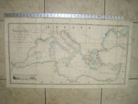
General Chart of the Mediterranean Sea Including the Gulf of Venice, Archipelago and Part of the Black Sea with the Steam Packet Routes
de Wyld, James (1812-1887)
- Usado
- Tapa blanda
- First
- Estado
- Usado - Very Good condition
- Edición
- First Edition
- Encuadernación
- Paperback
- Cantidad disponible
- 1
- Librería
-
Henderson, Nevada, United States
- Precio
-
EUR 741.50EUR 6.06 enviando a USA
Mostrar detalles
Descripción:
London: James Wyld, Geographer to Her Majesty, Charing Cross East, 1853. Very Good condition (only a little light soil) SEE PHOTOS. This huge detailed map of the Mediterranean measures 99.5cm by 54cm when unfolded. The image itself is 93.5cm by 47.5cm. There is a finely engraved view of the entrance of Gibraltar Bay in the lower left corner. The map is a linen-backed copper engraving with original hand coloring. The map has handsome marbled paper endsheets and when folded-up measures 18cm by 12.5cm. SEE PHOTOS. Published by James Wyld, Geographer to Her Majesty, Charing Cross East, London. A New General Atlas of Modern Geography Consisting of a Complete Collection of Maps of the Four Quarters of the Globe; Delineating their Physical Features and Coloured to Show the Limits of Their Respective States [1853].. First Edition. Linen-backed hand-colored map. Very Good condition. 99.5cm by 54cm when unfolded. Great Packaging, Fast Shipping.
Precio
EUR 741.50
EUR 6.06
enviando a USA

Foto de archivo: la portada puede ser diferente
Geography and Cartography, A Reference Handbook : Third Edition, Revised and Enlarged [NOT a library discard]
de Lock, C. B. Muriel [Clara Beatrice]
- Usado
- Tapa dura
- Estado
- Usado - Near Fine condition
- Edición
- Third Edition, Revised and Enlarged
- Encuadernación
- Hardcover
- ISBN 10 / ISBN 13
- 9780208015228 / 0208015221
- Cantidad disponible
- 1
- Librería
-
Henderson, Nevada, United States
- Precio
-
EUR 17.25EUR 6.06 enviando a USA
Mostrar detalles
Descripción:
London / Hamden, CT: Clive Bingley / Linnet Books, 1976. NOT a library discard. Near Fine condition in a Good+ dust jacket. The jacket has one closed tear (1.5 inches long). The background color of the jacket's spine has uniformly sun-mellowed from orange to a shade of yellow. All lettering remains sharp and distinct. NO owner's name or bookplate. NOT a remainder. Pages are clean and unmarked. NO underlining. NO highlighting. NO margin notes. 1976. Third Edition, Revised and Enlarged. This book combines into a single volume a newly revised edition of GEOGRAPHY, A REFERENCE HANDBOOK with an expanded edition of MODERN MAPS AND ATLASES. This is a glossary of terms and biographical profiles and an annotated bibliography of important geographical and cartographical publications. From the foreword: "The intention is to point out why the works are important, naming the significant features; these may be the presentation of new ideas or factual knowledge, the summary of otherwise…
Leer más Precio
EUR 17.25
EUR 6.06
enviando a USA
Foto de archivo: la portada puede ser diferente
Geography and Cartography, A Reference Handbook : Third Edition, Revised and Enlarged [NOT a library discard]
de Lock, C. B. Muriel [Clara Beatrice]
- Usado
- Tapa dura
- Estado
- Usado - Near Fine condition
- Edición
- Third Edition, Revised and Enlarged
- Encuadernación
- Hardcover
- ISBN 10 / ISBN 13
- 9780208015228 / 0208015221
- Cantidad disponible
- 1
- Librería
-
Henderson, Nevada, United States
- Precio
-
EUR 18.61EUR 6.06 enviando a USA
Mostrar detalles
Descripción:
London / Hamden, CT: Clive Bingley / Linnet Books, 1976. NOT a library discard. Near Fine condition in a Near Fine dust jacket. NO owner's name or bookplate. NOT a remainder. Pages are clean and unmarked. NO underlining. NO highlighting. NO margin notes. 1976. Third Edition, Revised and Enlarged. This book combines into a single volume a newly revised edition of GEOGRAPHY, A REFERENCE HANDBOOK with an expanded edition of MODERN MAPS AND ATLASES. This is a glossary of terms and biographical profiles and an annotated bibliography of important geographical and cartographical publications. From the foreword: "The intention is to point out why the works are important, naming the significant features; these may be the presentation of new ideas or factual knowledge, the summary of otherwise scattered material... or a work in some way unique." Bound in the original silver-stamped red boards. Complete with dust jacket.. Third Edition, Revised and Enlarged. Hardcover. Near Fine…
Leer más Precio
EUR 18.61
EUR 6.06
enviando a USA

¿No has encontrado lo que estabas buscando?
Prueba a añadir esta búsqueda a búsquedas guardadas Cada día se añaden millones de libros a Biblio. Cuando uno de ellos encaje con tu búsqueda, te enviaremos un correo para avisarte. Y lo mejor de todo, ¡es gratis!
Añadir a búsquedas guardadas

¿Eres un lector habitual o un coleccionista de libros?
Únete al Biblioclub y ahorra 10% en cada compra, ¡cada día! Hasta un máximo de 20$ en cada pedido

Responsabilidad social
¿Sabías que desde 2004 Biblio ha destinado sus beneficios a la construcción de 16 bibliotecas públicas en zonas rurales de Latinoamérica?
