Descripción:
Ordnance Survey, 1913. Revised Edition. Softcover. Good Condition/No Dust Jacket. Map Black and white map. Map is lightly marked with slightly darkened edges. Edges are slightly worn with some small tears which do not extend beyond the margins. No formal fold but light vertical creasing down the centre of sheet. Archive sticker and hand written figures in bottom right corner of sheet. Reverse is lightly marked. 1:2,500 Ordnance Survey Map, Yorkshire (North Riding) Sheet LIV.4. Edition of 1913, Re-Surveyed 1891, Revised 1912, Re-Levelled 1910, 25/23, Catterick (part) and Area to NE with Bolton upon Swale and North Ellerton Includes: Catterick (part), River Swale, Bolton upon Swale, North Ellerton, Ellerton Hill, Laylands, Bolton Beck, Brough Beck Back Lane, Springs Lane, Sled Lane, Flat Lane, Allotments Lane, Swale Pastures Lane, Bolton upon Swale: St. Mary's Church, Cumby Memorial School, Bolton Hall, The Grange Information included is buildings, property/field boundaries, acreage, parish and…
Leer más Resultados de búsqueda: Maps from Bailgate Books Ltd
Has buscado:
- Librería: Bailgate Books Ltd
- Tema: Maps from Bailgate Books Ltd
Resultados: 21 - 40 de 466

Más fotos
1:2,500 Ordnance Survey Map, Yorkshire (North Riding) Sheet LIV.4. Edition of 1913, Re-Surveyed 1891, Revised 1912, Re-Levelled 1910, 25/23, Catterick (part) and Area to NE with Bolton upon Swale and North Ellerton
de Ordnance Survey
- Usado
- Tapa blanda
- Estado
- Usado - Good Condition
- Edición
- Revised Edition
- Encuadernación
- Paperback
- Cantidad disponible
- 1
- Librería
-
Doncaster, Aberdeen, United Kingdom
- Precio
-
EUR 17.98EUR 17.38 enviando a USA
Mostrar detalles
Precio
EUR 17.98
EUR 17.38
enviando a USA

Más fotos
1:2,500 Ordnance Survey Map, Yorkshire (West Riding) Sheet CCLXI.12. Edition of 1906, Re-surveyed 1891, Revised 1904, 35/12, Park Mill and Surrounding Area
de Ordnance Survey
- Usado
- Tapa blanda
- Estado
- Usado - Good Condition
- Edición
- Revised Edition
- Encuadernación
- Paperback
- Cantidad disponible
- 1
- Librería
-
Doncaster, Aberdeen, United Kingdom
- Precio
-
EUR 17.98EUR 17.38 enviando a USA
Mostrar detalles
Descripción:
Ordnance Survey, 1906. Revised Edition. Softcover. Good Condition/No Dust Jacket. Map Black and white map. Reverse is lightly marked, with edges that are lightly worn, crumpled and darkened. One vertical fold which is worn and fragile, a further four vertical crease and one horizontal crease. Front of map is lightly marked and smudged with darkened edges. Small tears in the margin with one tear extending into mapped area at the top of the centre fold. Light pencil annotations and tape stains do intrude on mapped area. Handwritten figures in lower right corner 1:2,500 Ordnance Survey Map, Yorkshire (West Riding) Sheet CCLXI.5. Edition of 1932, Re-surveyed 1891, Revised 1930, Re-Levelled 1930.31, 100/32 25/44.Ch, Highburton and Kirkburton Includes: Highburton, Kirkburton, West Riding Mental Hospital (part), Storthes Hall, Dean Bottom, Far Dean, Burton Dean Carr Wood, Myers Wood, North Spring Wood Thunder Bridge Dike, Range Dike, L.M.S.R. Kirkburton Branch (railway) Storthes Hall Road, Woodsome Hall…
Leer más Precio
EUR 17.98
EUR 17.38
enviando a USA

Más fotos
1:2,500 Ordnance Survey Map, Yorkshire (West Riding) Sheet CCLXI.12. Edition of 1931, Re-surveyed 1891-2, Revised 1929, Re-Levelled 1930 75/31, Park Mill and Surrounding Area
de Ordnance Survey
- Usado
- Tapa blanda
- Estado
- Usado - Good Condition
- Edición
- Revised Edition
- Encuadernación
- Paperback
- Cantidad disponible
- 1
- Librería
-
Doncaster, Aberdeen, United Kingdom
- Precio
-
EUR 14.39EUR 17.38 enviando a USA
Mostrar detalles
Descripción:
Ordnance Survey, 1931. Revised Edition. Softcover. Good Condition/No Dust Jacket. Map Black and white map. Reverse is lightly marked, with edges that are lightly worn, crumpled and darkened. One vertical fold which is worn and fragile, a further four vertical crease and one horizontal crease. Front of map is lightly marked and smudged with darkened edges. Small tears in the margin with one tear extending into mapped area at the top of the centre fold. Light pencil annotations and tape stains do intrude on mapped area. Handwritten figures in lower right corner 1:2,500 Ordnance Survey Map, Yorkshire (West Riding) Sheet CCLXI.5. Edition of 1932, Re-surveyed 1891, Revised 1930, Re-Levelled 1930.31, 100/32 25/44.Ch, Highburton and Kirkburton Includes: Highburton, Kirkburton, West Riding Mental Hospital (part), Storthes Hall, Dean Bottom, Far Dean, Burton Dean Carr Wood, Myers Wood, North Spring Wood Thunder Bridge Dike, Range Dike, L.M.S.R. Kirkburton Branch (railway) Storthes Hall Road, Woodsome Hall…
Leer más Precio
EUR 14.39
EUR 17.38
enviando a USA

Más fotos
1:2,500 Ordnance Survey Map, Yorkshire (North Riding) Sheet CVI.7. Edition of 1911, Re-Surveyed 1890, Revised 1910, 30/41, Area West of Brawby with River Rye
de Ordnance Survey
- Usado
- Tapa blanda
- Estado
- Usado - Good Condition
- Edición
- Revised Edition
- Encuadernación
- Paperback
- Cantidad disponible
- 1
- Librería
-
Doncaster, Aberdeen, United Kingdom
- Precio
-
EUR 14.39EUR 17.38 enviando a USA
Mostrar detalles
Descripción:
Ordnance Survey, 1911. Revised Edition. Softcover. Good Condition/No Dust Jacket. Map Black and white map. Map is smudged and marked, particularly down the two vertical edges. The left hand edge is further affected with a darkened strip down the full vertical length of the sheet. No formal fold but vertical creasing down centre of sheet. Other light creasing and small tears to edges which do not extend beyond the margins into the mapped area. Hand written figures in bottom right corner and certain boundries highlighted in red ink. Reverse is smudged and marked with a darkened strip down the left edge. 1:2,500 Ordnance Survey Map, Yorkshire (North Riding) Sheet CVI.7. Edition of 1911, Re-Surveyed 1890, Revised 1910, 30/41, Area West of Brawby with River Rye Includes: High Waterholmes, Low Waterholmes, Glebe Farm, Fly Cross Bridge, The Kelds River Rye, Holbeck, Spring Beck, Double Dike, Ings Sewer Salton Road, Brawby Lane Information included is buildings, property/field boundaries, acreage, parish…
Leer más Precio
EUR 14.39
EUR 17.38
enviando a USA

Más fotos
1:2,500 Ordnance Survey Map, Yorkshire (West Riding) Sheet CCLXXIV.3. Edition of 1931, Re-Surveyed 1891, Revised 1929, Re-Levelled 1930, Area North of Barnsley, Wilthorpe, Hill Top (part) & Hill End (part)
de Ordnance Survey
- Usado
- Tapa blanda
- Estado
- Usado - Good Condition
- Edición
- Revised Edition
- Encuadernación
- Paperback
- Cantidad disponible
- 1
- Librería
-
Doncaster, Aberdeen, United Kingdom
- Precio
-
EUR 17.98EUR 17.38 enviando a USA
Mostrar detalles
Descripción:
Ordnance Survey, 1931. Revised Edition. Softcover. Good Condition/No Dust Jacket. Map Black and white map. Map is clean with slight wear and darkening to edges. Top right corner is torn and creased. Three vertical creases (all of which are slightly diagonal) but no formal central folds. Hand written figures in bottom right corner margin with faint stamp mark here also. Reverse is clean with three plain white reinforcing stickers. 1:2,500 Ordnance Survey Map, Yorkshire (West Riding) Sheet CCLXXIV.3. Edition of 1931, Re-Surveyed 1891, Revised 1929, Re-Levelled 1930, Area North of Barnsley, Wilthorpe, Hill Top (part) & Hill End (part) Includes: Barnsley (part), Wilthorpe, Smithies (part), Hill End (part), Hill Top (part), Swallow Hill (part), Willoe Bank, Day House L.M.S.R. Barnsley Branch (railway), L.N.E.R Stairfoot and Nostell (railway), Aire and Calder Navigation, River Dearne Carr Lane, Wakefeild Road, Smithies Lane Information included is buildings, property/field boundaries, acreage,…
Leer más Precio
EUR 17.98
EUR 17.38
enviando a USA

Más fotos
1:2,500 Ordnance Survey Map, Durham, Sheet XLII.11. Edition of 1897, Surveyed 1856, Revised 1896, 20/16, Shildon and New Shildon
de Ordnance Survey
- Usado
- Tapa blanda
- Estado
- Usado - Fair Condition
- Edición
- Revised Edition
- Encuadernación
- Paperback
- Cantidad disponible
- 1
- Librería
-
Doncaster, Aberdeen, United Kingdom
- Precio
-
EUR 26.38EUR 17.38 enviando a USA
Mostrar detalles
Descripción:
Ordnance Survey, 1897. Revised Edition. Softcover. Fair Condition/No Dust Jacket. Map Black and white map. Map is marked, smudged and darkened and has some faint pencil annotations. Edges are darkened and have adhesive fabric tape which is fraying and deteriorated in places. Right edge of map has dark strip extending into mapped area. Three tears to margin with associated tape stains, tear and tape to bottom edge extends into mapped area. Two vertical folds are notably rubbed and darkened, several other creases. Bottom right corner margin has hand written figures, the corner here is damaged and ragged. Reverse is marked and darkened. 1:2,500 Ordnance Survey Map, Durham, Sheet XLII.11. Edition of 1897, Surveyed 1856, Revised 1896, 20/16, Shildon and New Shildon Includes: Shildon, New Shildon (part), Shildon Wagon Works (part), Shildon Lodge Colliery, West Durham Wallsend Colliery Railways: N.E.R. Black Boy Branch, N.E.R. Darlington and Consett Line, Surtees Railway, Shildon Tunnel Information…
Leer más Precio
EUR 26.38
EUR 17.38
enviando a USA

Más fotos
1:2,500 Ordnance Survey Map, Yorkshire (West Riding) Sheet CCLXXIV.2. Edition of 1931, Re-Surveyed 1891, Revised 1929, Re-Levelled 1930, 100/31, Barugh with Low Barugh and Barugh Green
de Ordnance Survey
- Usado
- Tapa blanda
- Estado
- Usado - Good Condition
- Edición
- Revised Edition
- Encuadernación
- Paperback
- Cantidad disponible
- 1
- Librería
-
Doncaster, Aberdeen, United Kingdom
- Precio
-
EUR 23.98EUR 17.38 enviando a USA
Mostrar detalles
Descripción:
Ordnance Survey, 1931. Revised Edition. Softcover. Good Condition/No Dust Jacket. Map Black and white map. Map is almost clean with very faint marks and very slight darkening to edges. Right hand edge is worn and has slight smudging and light brown speckling. Bottom right corner has hand written figures in the margin along side a stamp mark. Corners show light wear. No formal fold but three light vertical creases. Reverse is only very lightly marked. 1:2,500 Ordnance Survey Map, Yorkshire (West Riding) Sheet CCLXXIV.2. Edition of 1931, Re-Surveyed 1891, Revised 1929, Re-Levelled 1930, 100/31, Barugh with Low Barugh and Barugh Green Includes: Barugh, Low Barugh, Barugh Green, Barugh Coke and By-Products Works, Chemical Works, Coalite Works, Barnby Basin, Barnby Bridge, Swallow Hill Farm Aire and Calder Navigation Barnsley Branch, River Dearne, Cawthorne Dike, Silkstone Beck, L.M.S.R. Silkstone Branch and Barnsley Branch (railways), Silkstone Junction Information included is buildings,…
Leer más Precio
EUR 23.98
EUR 17.38
enviando a USA

Más fotos
1:2,500 Ordnance Survey Map, Durham, Sheet XLII.2. Edition of 1897, Surveyed 1856, Revised 1896, 50/07, Bishop Auckland and Area to West with Escomb (part) and Etherley Dene
de Ordnance Survey
- Usado
- Tapa blanda
- Estado
- Usado - Fair Condition
- Edición
- Revised Edition
- Encuadernación
- Paperback
- Cantidad disponible
- 1
- Librería
-
Doncaster, Aberdeen, United Kingdom
- Precio
-
EUR 29.97EUR 17.38 enviando a USA
Mostrar detalles
Descripción:
Ordnance Survey, 1897. Revised Edition. Softcover. Fair Condition/No Dust Jacket. Map Coloured map. Map is marked, smudged and darkened. Edges are slightly darker and are worn and in places torn. Three vertical folds and one horizontal fold. Folds are fragile, worn and rubbed, the central vertical fold particularly so with tears at top and bottom of fold. Certain buildings have been highlighted in colour and there is light pencil annotation. Bottom right corner margin has hand written figures, an archive sticker and a stamp mark. Reverse is smudged and stained and has tape patches. 1:2,500 Ordnance Survey Map, Durham, Sheet XLII.2. Edition of 1897, Surveyed 1856, Revised 1896, 50/07, Bishop Auckland and Area to West with Escomb (part) and Etherley Dene Includes: Bishop Auckland, Town Head, Primrose Hill, Newton Cap (part), Etherley Dene, Etherley Moor, Escomb (part), West Mill, River Wear, N.E.R. Darlington and Consett Line (railway) Etherley Lane, Cockton Hill, Newgate Street, Tenters Street…
Leer más Precio
EUR 29.97
EUR 17.38
enviando a USA

1:2500 Ordnance Survey Map, Yorkshire (East Riding) Sheet CXCII 13, Edition of 1910, Re-Surveyed in 1890, Revised in 1908, Reprint 25/45 Wa, Large-scale plan of the area between the villages of Wheldrake, Thorganby and Escrick, SE of York
de Ordnance Survey
- Usado
- Estado
- Usado - Very Good Condition
- Edición
- Revised Edition
- Cantidad disponible
- 1
- Librería
-
Doncaster, Aberdeen, United Kingdom
- Precio
-
EUR 11.39EUR 17.38 enviando a USA
Mostrar detalles
Descripción:
Ordnance Survey, 1908. Revised Edition. Single sheet. Very Good Condition/No Dust Jacket. Map Large-scale plan of the area between the villages of Wheldrake, Thorganby and Escrick, SE of York. Map shows; part Leonard Scales Lane, South Plantation, South Close, Keld Carrs, Keld Carrs Drain, Simpson's Wood, Crinklety's Wood, Common Drain, Common Lane, Common Bottoms Wood, Westhow Field, Westhow Closes, Sandhole Lane, Common Farm, Southmoor Drain, South moor, Poor's Close, Pallion Dike, Gray Reins, Acorn Plantation, West Cottingwith Common, Keldcarrs Plantation, Gilbertson's Wood, Gilbertson's Farm, Wheldrake Wrays and Grange Farm. Includes parts of Thorganby with West Cottingwith, Escrick and Wheldrake Parish and York Union & Escrick RD along with Howdenshire Division. Information included is buildings, property/field boundaries, acreage, parish and other boundaries, footpaths, tracks, roads, railways, watercourses, orchards and forestation, levels, earthworks, antiquities…
Leer más Precio
EUR 11.39
EUR 17.38
enviando a USA

Más fotos
1:2500 Ordnance Survey Map, Yorkshire (West Riding) Sheet CCLIX.14. Second Edition 1906, Resurveyed in 1890, Revised in 1904, Reprint 25/23, 50/36. Standedge Tunnel, Manchester Road (A62) & Redbrook Reservoir
de Ordnance Survey
- Usado
- Tapa blanda
- Estado
- Usado - Very Good Condition
- Edición
- Revised Edition
- Encuadernación
- Paperback
- Cantidad disponible
- 1
- Librería
-
Doncaster, Aberdeen, United Kingdom
- Precio
-
EUR 17.98EUR 17.38 enviando a USA
Mostrar detalles
Descripción:
Ordnance Survey, 1906. Revised Edition. Softcover. Very Good Condition/No Dust Jacket. Map Black and white map two marginal areas darkened from no-longer present adhesive tape. Some short tears from the edges in margins only, light crumpling and rubbed slightly darkened edges. One light vertical crease down centre - no formal fold. Brief pen and pencil annotation in lower right margin. 1:2500 Ordnance Survey Map, Yorkshire (West Riding) Sheet CCLIX.14. Second Edition 1906, Resurveyed in 1890, Revised in 1904, Reprint 25/23, 50/36. Standedge Tunnel, Manchester Road (A62) & Redbrook Reservoir. Area is between Delph and Diggle and Marsden. Includes: Standedge, Brun Moor, Foul Moss, Millstone Edge, Warcock, Cabe Whams, Roundhill, Redbrook Reservoir, Brunclough Compensation Reservoir, Thieves Clough, Standedge Tunnel, Standedge Cutting, Huddersfield Canal, L & N.W.R Huddersfield and Manchester Line (Railway), Manchester Road. Great Western Inn, The Floating Light Inn, Brun, Globe Farm, Higher…
Leer más Precio
EUR 17.98
EUR 17.38
enviando a USA

Más fotos
1:2500 Ordnance Survey Map, Yorkshire (West Riding) Sheet CCLX.13. Edition of 1932, Resurveyed in 1888-90, Revised in 1929, Re-levelled in 1930-31,Reprint 100/32. Meltham (Part) & Area Immediately South-West
de Ordnance Survey
- Usado
- Tapa blanda
- Estado
- Usado - Good Condition
- Edición
- Revised Edition
- Encuadernación
- Paperback
- Cantidad disponible
- 1
- Librería
-
Doncaster, Aberdeen, United Kingdom
- Precio
-
EUR 11.39EUR 17.38 enviando a USA
Mostrar detalles
Descripción:
Ordnance Survey, 1932. Revised Edition. Softcover. Good Condition/No Dust Jacket. Map Black and white map. Edges are worn with multiple short tears from the edges in margins only, but previous tape (not now present) has extended into map and created discoloured patches and one tear extends into map, Also light smudges, light crumpling and rubbed slightly darkened edges. Three vertical folds/creases and one horizontal crease. Short blue and red annotation in lower right margin and in the top margin. Reverse is much darkened with stickers patching-up the edge. 1:2500 Ordnance Survey Map, Yorkshire (West Riding) Sheet CCLX.13. Edition of 1932, Resurveyed in 1888-90, Revised in 1929, Re-levelled in 1930-31,Reprint 100/32. Meltham (Part) & Area Immediately South-West Includes: Meltham (part), Calmlands, Mills, Albion Moor Road, Royd Edge Dye Works, Meltham Convalescent Home. Catchwater Drain, Deer Hill Bents (part), Oldfield Hill, Banister Edge, Royd Edge, Royd Planatation, Laggin Plat, Thick…
Leer más Precio
EUR 11.39
EUR 17.38
enviando a USA

Más fotos
1:2500 Ordnance Survey Map, Yorkshire (West Riding) Sheet CCLXI.9. Edition of 1931, Resurveyed 1891, Rev. 1929, Re-Levelled 1930, Rev. 75/31 Thunder Bridge and Surrounding Area
de Ordnance Survey
- Usado
- Tapa blanda
- Estado
- Usado - Good Condition
- Edición
- Revised Edition
- Encuadernación
- Paperback
- Cantidad disponible
- 1
- Librería
-
Doncaster, Aberdeen, United Kingdom
- Precio
-
EUR 11.39EUR 17.38 enviando a USA
Mostrar detalles
Descripción:
Ordnance Survey, 1932. Revised Edition. Softcover. Good Condition/No Dust Jacket. Map Black and white map. Edges are slightly crumpled corners, short tears in margins and a tape stain, upper edge is darkened and has two small areas of loss in the margin. Front of map is slightly darkened and with light marks and there is a short tear that has been repaired on the reverse. Two vertical folds with short tears at each end of one. Annotation in lower right margin. 1:2500 Ordnance Survey Map, Yorkshire (West Riding) Sheet CCLXI.9. Edition of 1931, Resurveyed 1891, Rev. 1929, Re-Levelled 1930, Rev. 75/31 Thunder Bridge and Surrounding Area. Includes: Thunder Bridge, Shelley Far Bank (part), West Riding Mental Hospital (part), Causeway Foot, Grange, Heal. Boothroyd Wood, Saville Wood, Smith Wood (part), Laycock Wood, Hartley Bank Wood, Birks Wood, Healey Greave Wood, Shelley Wood, Allen Wood. (Railway) L.M.S.R. Huddersfield & Penistone Line, Carr Dike, Box Ings Dike, Sewage Works, Corn Mills, Shepley…
Leer más Precio
EUR 11.39
EUR 17.38
enviando a USA

Más fotos
1:2500 Ordnance Survey Map, Yorkshire (West Riding) Sheet CCLXI.7. Edition of 1932, Resurveyed 1891, Rev. 1930, Re-Levelled 1931, Rev. 100/32 Emley and Surrounding Area
de Ordnance Survey
- Usado
- Tapa blanda
- Estado
- Usado - Good Condition
- Edición
- Revised Edition
- Encuadernación
- Paperback
- Cantidad disponible
- 1
- Librería
-
Doncaster, Aberdeen, United Kingdom
- Precio
-
EUR 11.39EUR 17.38 enviando a USA
Mostrar detalles
Descripción:
Ordnance Survey, 1932. Revised Edition. Softcover. Good Condition/No Dust Jacket. Map Black and white map. Tape stain on lower edge (margin only), slight darkening, light crumpling and nicks and short tears at edges (margins only). Light smudges and marks on map surface, four pencil marks, one main vertical fold with associated light creasing, several light vertical creases. Annotation in lower right margin. Reverse is lightly marked and darkened. 1:2500 Ordnance Survey Map, Yorkshire (West Riding) Sheet CCLXI.7. Edition of 1932, Resurveyed 1891, Rev. 1930, Re-Levelled 1931, Rev. 100/32 Emley and Surrounding Area Includes: Emley, Warburton, Hag Hill, Upper and Lower Crawshaw, Springfield, Speedwell Colliery, Westfield. Broom Field Lane, Chapel Lane, Stringer House Lane, Church Street, Tipping Lane, Tyburn Lane. Mouse House Dike, Out Lane Dike. Information included is buildings, property/field boundaries, acreage, parish and other boundaries, footpaths, tracks, roads, railways, watercourses,…
Leer más Precio
EUR 11.39
EUR 17.38
enviando a USA

1:2500 Ordnance Survey Map, Leicestershire Sheet XIV.1, Second Edition 1904, Surveyed in 1884, Revised in 1902, Reprint 40/41, Large-scale plan of the area north of the village of Saltby in Leicestershire
de Ordnance Survey
- Usado
- Estado
- Usado - Very Good Condition
- Edición
- Revised Edition
- Cantidad disponible
- 1
- Librería
-
Doncaster, Aberdeen, United Kingdom
- Precio
-
EUR 11.39EUR 17.38 enviando a USA
Mostrar detalles
Descripción:
Ordnance Survey, 1904. Revised Edition. Single sheet. Very Good Condition/No Dust Jacket. Map Includes: Saltby Lodge, farm (Swallow Hole Farm), farm (Barn Lodge Farm) , farm (Heath Farm), Swallowhole Covert, Swallow Hole (geological feature), Bescaby Oaks and Croxton Park (Old Wood). Parts of parishes included are: Saltby, Bescaby and Croxton Kerrial. The area is in the Melton Mowbray Union & RD and Grantham Union and Bevoir RD. Information included is buildings, property/field boundaries, acreage, parish and other boundaries, footpaths, tracks, roads, railways, watercourses, orchards and forestation, levels, earthworks, antiquities etc. The map has an inked stamp in the bottom margin and reference number in the bottom right corner (margin). Item Type: Map. Quantity Available: 1. Shipped Weight: under 1 kg. Pictures of this item not already displayed here available upon request. Inventory No: 45110120060. For international tracking please select Priority shipping service..
Precio
EUR 11.39
EUR 17.38
enviando a USA

Más fotos
1839 Map of the County of Buckinghamshire - taken from Pigot and Co's British Atlas Comprising the Counties of England (upon which are laid down all railways completed and in progress)
de Pigot & Co
- Usado
- fair
- Estado
- Usado - Fair
- Edición
- Edition Unstated
- Cantidad disponible
- 1
- Librería
-
Doncaster, Aberdeen, United Kingdom
- Precio
-
EUR 21.58EUR 17.38 enviando a USA
Mostrar detalles
Descripción:
Pigot and Co, London and Manchester, London and Manchester, 1839. Edition Unstated. Disbound. Fair/No Dust Jacket. Map Dated from reference to British Library catelogue and title-page of atlas. This is the coloured map titled "Buckinghamshire" and sheet also titled "Buckinghamshire". The map, a hand-coloured (prior to initial binding) steel engraving contains a vignette of Newport Pagnall Church. The inner side of the Buckinghamshire county boundary is coloured yellow, inner boundaries of adjacent counties Bedfordshire, Hertfordshire, Middlesex, Berkshire, Oxfordshire and Northamptonshire are coloured pale green, blue or pink. Wooded areas and rough ground are indicated. Country estates are coloured dark green and include: Stow Park, Bulrode Park, Langley Park, Wilton Park and Stoke Park. The map shows cities, market towns, villages and hamlets, the distance between the towns and cities and London is shown, also shown are the numbers of members returned for each borough and…
Leer más Precio
EUR 21.58
EUR 17.38
enviando a USA

Más fotos
1839 Map of the County of Herefordshire - taken from Pigot and Co's British Atlas Comprising the Counties of England (upon which are laid down all railways completed and in progress)
de Pigot and Co
- Usado
- Muy bueno
- Tapa blanda
- Estado
- Usado - Muy bueno
- Edición
- Edition Unstated
- Encuadernación
- Paperback
- Cantidad disponible
- 1
- Librería
-
Doncaster, Aberdeen, United Kingdom
- Precio
-
EUR 33.57EUR 17.38 enviando a USA
Mostrar detalles
Descripción:
Pigot & Co, London and Manchester, 1839. Edition Unstated. Softcover. Very Good/No Dust Jacket. Map Dated from reference to British Library catalogue and title-page of atlas. This is the coloured map titled "Herefordshire" and sheet entitled "Herefordshire". The map, a hand-coloured (prior to initial binding) steel engraving contains a vignette of Hereford Cathedral. The inner side of the Herefordshire county boundary is coloured yellow, inner boundaries of adjacent counties of Worcestershire, Radnorshire, Monmouthshire, Shropshire, Glocestershire and Brecknockshire are coloured pale green, blue or pink. Wooded areas and rough ground are indicated. Country estates are coloured dark green and include Hampton and Brampton Parks. The map shows cities, market towns, villages and hamlets, the distance between the towns and cities and London is shown, also shown are the numbers of members returned for each borough and polling places. Towns shown include: Bromyard, Hereford,…
Leer más Precio
EUR 33.57
EUR 17.38
enviando a USA

Más fotos
1884 Blackie's Map of Western Africa
de W. G. Blackie
- Usado
- Tapa blanda
- Estado
- Usado - Very Good Condition
- Edición
- Early Edition
- Encuadernación
- Paperback
- Cantidad disponible
- 1
- Librería
-
Doncaster, Aberdeen, United Kingdom
- Precio
-
EUR 19.18EUR 17.38 enviando a USA
Mostrar detalles
Descripción:
Blackie & Son, London, Glasgow, Edinburgh and Dublin, 1884. Early Edition. Softcover. Very Good Condition/No Dust Jacket. Illustrator: Drawn and Engraved by J. Bartholomew. Map Disbound map from the 1884 "Comprehensive Atlas & Geography of the World: Comprising an Extensive Series of Maps, a Description, Physical and Political, of all the Countries of the Earth; a Pronouncing Vocabulary of Geographical Names, and a Copious Index of Geographical Positions... Compiled and Engraved from the Most Authentic Sources, Under the Supervision of W. G. Blackie, PhD., F.S.A.Scot." Sheet number covers Single sheet with horizontal centre fold. Sheet is clean but slightly darkened at the edges. Map is drawn to a given scale with latitude and longitude lines, map is extensively labeled. Pastel shades have been used to denote countries and slightly darker shades have been used to denote boarders. Black and white engraved hatching shows landscape features. Size: 38x56cm. Item Type: Map. No dust…
Leer más Precio
EUR 19.18
EUR 17.38
enviando a USA
Más fotos
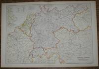
1884 Blackie's Map of Central Europe, showing the Principal Railways and the Political Boundaries
de W. G. Blackie
- Usado
- Tapa blanda
- Estado
- Usado - Very Good Condition
- Edición
- Early Edition
- Encuadernación
- Paperback
- Cantidad disponible
- 1
- Librería
-
Doncaster, Aberdeen, United Kingdom
- Precio
-
EUR 21.58EUR 17.38 enviando a USA
Mostrar detalles
Descripción:
Blackie & Son, London, Glasgow, Edinburgh and Dublin, 1884. Early Edition. Softcover. Very Good Condition/No Dust Jacket. Illustrator: Drawn and Engraved by J. Bartholomew. Map Disbound map from the 1884 "Comprehensive Atlas & Geography of the World: Comprising an Extensive Series of Maps, a Description, Physical and Political, of all the Countries of the Earth; a Pronouncing Vocabulary of Geographical Names, and a Copious Index of Geographical Positions... Compiled and Engraved from the Most Authentic Sources, Under the Supervision of W. G. Blackie, PhD., F.S.A.Scot." Sheet number covers Single sheet with horizontal centre fold. Sheet is clean but slightly darkened at the edges. Map is drawn to a given scale with latitude and longitude lines, map is extensively labeled. Pastel shades have been used to denote countries and slightly darker shades have been used to denote boarders. Black and white engraved hatching shows landscape features. Size: 38x56cm. Item Type: Map. No dust…
Leer más Precio
EUR 21.58
EUR 17.38
enviando a USA

Más fotos
1884 Blackie's Map of Marocco, Algeria and Tunis
de W. G. Blackie
- Usado
- Tapa blanda
- Estado
- Usado - Very Good Condition
- Edición
- Early Edition
- Encuadernación
- Paperback
- Cantidad disponible
- 1
- Librería
-
Doncaster, Aberdeen, United Kingdom
- Precio
-
EUR 19.18EUR 17.38 enviando a USA
Mostrar detalles
Descripción:
Blackie & Son, London, Glasgow, Edinburgh and Dublin, 1884. Early Edition. Softcover. Very Good Condition/No Dust Jacket. Illustrator: Drawn and Engraved by J. Bartholomew. Map Disbound map from the 1884 "Comprehensive Atlas & Geography of the World: Comprising an Extensive Series of Maps, a Description, Physical and Political, of all the Countries of the Earth; a Pronouncing Vocabulary of Geographical Names, and a Copious Index of Geographical Positions... Compiled and Engraved from the Most Authentic Sources, Under the Supervision of W. G. Blackie, PhD., F.S.A.Scot." Sheet number covers Single sheet with horizontal centre fold. Sheet is clean but slightly darkened at the edges. Map is drawn to a given scale with latitude and longitude lines, map is extensively labeled. Pastel shades have been used to denote countries and slightly darker shades have been used to denote boarders. Black and white engraved hatching shows landscape features. Size: 38x56cm. Item Type: Map. No dust…
Leer más Precio
EUR 19.18
EUR 17.38
enviando a USA

Más fotos
1884 Blackie's Map of Canada - The Provinces of Quebec, Nova Scotia, New Brunswick, Prince Edward Island and Newfoundland
de W. G. Blackie
- Usado
- Tapa blanda
- Estado
- Usado - Very Good Condition
- Edición
- Early Edition
- Encuadernación
- Paperback
- Cantidad disponible
- 1
- Librería
-
Doncaster, Aberdeen, United Kingdom
- Precio
-
EUR 20.38EUR 17.38 enviando a USA
Mostrar detalles
Descripción:
Blackie & Son, London, Glasgow, Edinburgh and Dublin, 1884. Early Edition. Softcover. Very Good Condition/No Dust Jacket. Illustrator: Drawn and Engraved by J. Bartholomew. Map Disbound map from the 1884 "Comprehensive Atlas & Geography of the World: Comprising an Extensive Series of Maps, a Description, Physical and Political, of all the Countries of the Earth; a Pronouncing Vocabulary of Geographical Names, and a Copious Index of Geographical Positions... Compiled and Engraved from the Most Authentic Sources, Under the Supervision of W. G. Blackie, PhD., F.S.A.Scot." Single sheet with vertical centre fold. Sheet is clean but slightly darkened at the edges. Map is drawn to a given scale with latitude and longitude lines, map is extensively labeled. Pastel shades have been used to denote countries and slightly darker shades have been used to denote boarders. Black and white engraved hatching shows landscape features. Size: 38x56cm. Item Type: Map. No dust jacket, as published.…
Leer más Precio
EUR 20.38
EUR 17.38
enviando a USA

¿No has encontrado lo que estabas buscando?
Prueba a añadir esta búsqueda a búsquedas guardadas Cada día se añaden millones de libros a Biblio. Cuando uno de ellos encaje con tu búsqueda, te enviaremos un correo para avisarte. Y lo mejor de todo, ¡es gratis!
Añadir a búsquedas guardadas

¿Eres un lector habitual o un coleccionista de libros?
Únete al Biblioclub y ahorra 10% en cada compra, ¡cada día! Hasta un máximo de 20$ en cada pedido

Responsabilidad social
¿Sabías que desde 2004 Biblio ha destinado sus beneficios a la construcción de 16 bibliotecas públicas en zonas rurales de Latinoamérica?
