Descripción:
The Times Publishing Company Ltd, London, 1959. Mid-Century Edition. Softcover. Fine Condition/No Dust Jacket. Single disbound map sheet from 'The Times Atlas of the World, Mid-Century Edition; Volume II Eurasia, suitable for framing. Map is in colour and has vertical centre fold. Approx. sheet size is 49 x 61cm. Sheet is clean, bright and crisp. Scale 1:4,000,000. Map shows relief, national and other boundaries, cities, town, rivers main roads, some tracks, railways, oil pipe lines, mangrove Swamps, main civil airports and other airfields etc. Inset maps of Andaman Island and Nicobar Island at 1:4,000,000 scale. Inset plans of Bombay and Madras showing main roads, green areas, railways etc. at 1:200,000 scale First printing of this edition. Quantity Available: 1. Shipped Weight: under 1 kg. Pictures of this item not already displayed here available upon request. Inventory No: 45022081062. For international tracking please select Priority shipping service..
Resultados de búsqueda: Maps from Bailgate Books Ltd
Has buscado:
- Librería: Bailgate Books Ltd
- Tema: Maps from Bailgate Books Ltd
Resultados: 21 - 40 de 466

Más fotos
Map of 'India South and India North-East', Plate 28 disbound from 1959 Mid-Century Times Atlas of the World, Volume II, (South-West Asia and Russia) includes India, East Pakistan, Ceylon, Andaman Islands, Nicobar Islands
de John Bartholomew
- Usado
- Tapa blanda
- Estado
- Usado - Fine Condition
- Edición
- Mid-Century Edition
- Encuadernación
- Paperback
- Cantidad disponible
- 1
- Librería
-
Doncaster, Aberdeen, United Kingdom
- Precio
-
EUR 33.15EUR 17.17 enviando a USA
Mostrar detalles
Precio
EUR 33.15
EUR 17.17
enviando a USA

Más fotos
Map of U.S.S.R. Leningrad, Urals, Plate 47 disbound from 1959 Mid-Century Times Atlas of the World, Volume II, (South-West Asia & Russia) Scale 1: 5,000,000. Inset plans of Industrial Urals 1:2,500,000 and Leningrad 1:100,000
de John Bartholomew
- Usado
- Tapa blanda
- Estado
- Usado - Fine Condition
- Edición
- Mid-Century Edition
- Encuadernación
- Paperback
- Cantidad disponible
- 1
- Librería
-
Doncaster, Aberdeen, United Kingdom
- Precio
-
EUR 37.88EUR 17.17 enviando a USA
Mostrar detalles
Descripción:
The Times Publishing Company Ltd, London, 1959. Mid-Century Edition. Softcover. Fine Condition/No Dust Jacket. Single disbound map sheet from 'The Times Atlas of the World, Mid-Century Edition; Volume II Eurasia, suitable for framing. Map is in colour and has vertical centre fold. Approx. sheet size is 49 x 61cm. Sheet is clean, bright and crisp. Scale 1:2,5000,000. Includes parts of Finland, Norway, Sweden Map shows relief, International Boundaries, S.S.R. boundaries A.S.S.R, Oblast boundaries, cities, town, rivers, main roads, railways, main civil airports and other airfields, canals, oil pipe lines, marsh and flood areas, salt lakes. Leningrad inset shows stations, parks, road grid, state buildings, hotels, museums etc. Key map on reverse and glossary of Russian Geographical Terms and Abbreviations of Principal Soviet Administrative Areas. First printing of this edition. Single sheet map/chart which is suitable for framing and will be shipped rolled and in a cardboard tube. Quantity…
Leer más Precio
EUR 37.88
EUR 17.17
enviando a USA

Más fotos
Map of U.S.S.R. Kolyma, Kamchatka, Plate 39 disbound from 1959 Mid-Century Times Atlas of the World, Volume II, (South-West Asia & Russia) Scale 1: 5,000,000. Small part of Alaska, inset map of O. Vrangelya (Wrangel Island)
de John Bartholomew
- Usado
- Tapa blanda
- Estado
- Usado - Fine Condition
- Edición
- Mid-Century Edition
- Encuadernación
- Paperback
- Cantidad disponible
- 1
- Librería
-
Doncaster, Aberdeen, United Kingdom
- Precio
-
EUR 33.15EUR 17.17 enviando a USA
Mostrar detalles
Descripción:
The Times Publishing Company Ltd, London, 1959. Mid-Century Edition. Softcover. Fine Condition/No Dust Jacket. Single disbound map sheet from 'The Times Atlas of the World, Mid-Century Edition; Volume II Eurasia, suitable for framing. Map is in colour and has vertical centre fold. Approx. sheet size is 49 x 61cm. Sheet is clean, bright and crisp. Scale 1:5,000,000 Also shows Saint Lawrence Island, Aleutian Islands, Saint Matthew Island, Komandorskiye Ostrova. Map shows relief, national boundaries, cities, town, rivers, main roads, , railways, main civil airports and other airfields. Key map on reverse and glossary of Russian Geographical Terms and Abbreviations of Principal Soviet Administrative Areas. First printing of this edition. Quantity Available: 1. Shipped Weight: under 1 kg. Pictures of this item not already displayed here available upon request. Inventory No: 45022081072. For international tracking please select Priority shipping service..
Precio
EUR 33.15
EUR 17.17
enviando a USA

Más fotos
Map of U.S.S.R. Khabarovsk, Vladivostok, Plate 40 disbound from 1959 Mid-Century Times Atlas of the World, Volume II, (South-West Asia & Russia) Scale 1: 5,000,000. Includes small part of Japan
de John Bartholomew
- Usado
- Tapa blanda
- Estado
- Usado - Fine Condition
- Edición
- Mid-Century Edition
- Encuadernación
- Paperback
- Cantidad disponible
- 1
- Librería
-
Doncaster, Aberdeen, United Kingdom
- Precio
-
EUR 33.15EUR 17.17 enviando a USA
Mostrar detalles
Descripción:
The Times Publishing Company Ltd, London, 1959. Mid-Century Edition. Softcover. Fine Condition/No Dust Jacket. Single disbound map sheet from 'The Times Atlas of the World, Mid-Century Edition; Volume II Eurasia, suitable for framing. Map is in colour and has vertical centre fold. Approx. sheet size is 49 x 61cm. Sheet is clean, bright and crisp. Scale 1:5,000,000. Includes Kurilskiye Ostrova (Kuril Islands) and its volcanoes. Map shows relief, Oblast and Kray Boundaries, cities, town, rivers, main roads, railways, main civil airports and other airfields, active volcanoes. Key map on reverse and glossary of Russian Geographical Terms and Abbreviations of Principal Soviet Administrative Areas. First printing of this edition. Quantity Available: 1. Shipped Weight: under 1 kg. Pictures of this item not already displayed here available upon request. Inventory No: 45022081073. For international tracking please select Priority shipping service..
Precio
EUR 33.15
EUR 17.17
enviando a USA
Más fotos
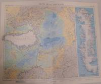
Map of Arctic Ocean Greenland, Plate 48 disbound from 1959 Mid-Century Times Atlas of the World, Volume II, (South-West Asia & Russia) Scale 1:12,500,000, four insets of Greenland Coastal Settlements 1:5,000,000
de John Bartholomew
- Usado
- Tapa blanda
- Estado
- Usado - Fine Condition
- Edición
- Mid-Century Edition
- Encuadernación
- Paperback
- Cantidad disponible
- 1
- Librería
-
Doncaster, Aberdeen, United Kingdom
- Precio
-
EUR 44.98EUR 17.17 enviando a USA
Mostrar detalles
Descripción:
The Times Publishing Company Ltd, London, 1959. Mid-Century Edition. Softcover. Fine Condition/No Dust Jacket. Single disbound map sheet from 'The Times Atlas of the World, Mid-Century Edition; Volume II Eurasia, suitable for framing. Map is in colour and has vertical centre fold. Approx. sheet size is 49 x 61cm. Sheet is clean, bright and crisp. Scale 1:12,5000,000. Map shows relief, cities, town, rivers, main roads, railways, main civil airports and other airfields, extreme limit of pack ice, limit of drift ice, glaciers and ice-caps. Includes route of "Fram" 1893-1896 and of Nautilus August 1958. Includes Iceland. Also parts of North America, Europe, Asia Key map on reverse and glossary of Russian Geographical Terms and Abbreviations of Principal Soviet Administrative Areas. First printing of this edition. Single sheet map/chart which is suitable for framing and will be shipped rolled and in a cardboard tube. Quantity Available: 1. Shipped Weight: under 1 kg. Pictures of this…
Leer más Precio
EUR 44.98
EUR 17.17
enviando a USA

Más fotos
Above the World, Stunning Satellite Images From Above Earth
de NPA Group
- Usado
- Tapa dura
- First
- Estado
- Usado - Very Good Condition
- Edición
- First Edition
- Encuadernación
- Hardcover
- ISBN 10 / ISBN 13
- 9781844031818 / 1844031810
- Cantidad disponible
- 1
- Librería
-
Doncaster, Aberdeen, United Kingdom
- Precio
-
EUR 33.62EUR 17.17 enviando a USA
Mostrar detalles
Descripción:
Cassell Illustrated, Octopus Publishing, London, 2004. First Edition. Hardcover. Very Good Condition/No Dust Jacket. Lower corners of black covers are bumped. Black covers with silver lettering on the spine. Fresh covers, sound binding, clean pages and end-papers. Contains many colour plates (full page illustrations). No dust-jacket. Previous owner's name, Kerry Downes, in pencil at the front. Quantity Available: 1. Shipped Weight: 2-3 kg. ISBN: 1844031810. ISBN/EAN: 9781844031818. Pictures of this item not already displayed here available upon request. Inventory No: 45422021181. For international tracking please select Priority shipping service.. 9781844031818 This book is heavier than 1kg, and may incur additional delivery charges on some delivery services to some locations..
Precio
EUR 33.62
EUR 17.17
enviando a USA

Más fotos
Antique Maps
de Carl Moreland and David Bannister
- Usado
- Tapa blanda
- Estado
- Usado - Near Fine Condition
- Edición
- Third Edition
- Encuadernación
- Paperback
- ISBN 10 / ISBN 13
- 9780714829548 / 0714829544
- Cantidad disponible
- 1
- Librería
-
Doncaster, Aberdeen, United Kingdom
- Precio
-
EUR 16.22EUR 17.17 enviando a USA
Mostrar detalles
Descripción:
Phaidon, 1989. Third Edition. Softcover. Near Fine Condition/No Dust Jacket. Crisp clean covers, tight binding, clean pages and inside covers. No dust jacket, as published. Previous owner's name, Kerry Downes, in pencil at the front. Quantity Available: 1. Shipped Weight: 1-2kg. ISBN: 0714829544. ISBN/EAN: 9780714829548. Pictures of this item not already displayed here available upon request. Inventory No: 45022021123. For international tracking please select Priority shipping service.. 9780714829548 This book is heavier than 1kg, and may incur additional delivery charges on some delivery services to some locations..
Precio
EUR 16.22
EUR 17.17
enviando a USA
Más fotos
The Phaidon Atlas of Contemporary World Architecture, Comprehensive Edition
de Phaidon, designed by Hamish Muir
- Usado
- Tapa dura
- First
- Estado
- Usado - Very Good Condition
- Edición
- First Edition
- Encuadernación
- Hardcover
- ISBN 10 / ISBN 13
- 9780714843124 / 0714843121
- Cantidad disponible
- 1
- Librería
-
Doncaster, Aberdeen, United Kingdom
- Precio
-
EUR 116.84EUR 17.17 enviando a USA
Mostrar detalles
Descripción:
Phaidon Press Ltd, London and New York, 2004. First Edition. Hardcover. Very Good Condition/No Dust Jacket. Green covers with silver lettering on spine and rear but sunned to yello on spine and front, lightly marked on rear. Sound binding, clean pages and plates.Packed weight 7-8 kg. Size: Folio. 810 pages. One volume of the 1-volume set. Contains many colour plates (full page illustrations). No dust-jacket. Quantity Available: 1. Shipped Weight: over 4 kg. ISBN: 0714843121. ISBN/EAN: 9780714843124. Pictures of this item not already displayed here available upon request. Inventory No: 25022021009. For international tracking please select Priority shipping service.. 9780714843124 This book is heavier than 1kg, and may incur additional delivery charges on some delivery services to some locations..
Precio
EUR 116.84
EUR 17.17
enviando a USA

Más fotos
A New and Exact Plan of the City of York
de John Cossins
- Usado
- Tapa dura
- Estado
- Usado - Near Fine Condition
- Edición
- Reprint
- Encuadernación
- Hardcover
- Cantidad disponible
- 1
- Librería
-
Doncaster, Aberdeen, United Kingdom
- Precio
-
EUR 132.59EUR 17.17 enviando a USA
Mostrar detalles
Descripción:
Alex G Jackson, Leeds, 1975. Reprint. Hardcover. Near Fine Condition/No Dust Jacket. Drawn & Surveyed by John Cossins, Engraved by B Cole 1740, The amendments added in 1748, engraved by J Haynes, York. This copy is printed the exact size on 2 sheets as the original. Only 150 copies have been printed & of these 50 are hand bound in 1/4 calf (this is) No. 43 Alex G Jackson." "Bound by Etherington, Thorpe and Co. Ltd, Calverley, Pudsey. Quarter-leather binding with brown covers and brown label with gilt lettering. Folded map, clean , crisp and intact, with marbled backing to opening panel. Printed details on inside of front cover. Leather spine is lightly rubbed with fine cracking over front joint. No dust jacket, as published. Undated by publisher. Quantity Available: 1. Shipped Weight: under 1 kg. Pictures of this item not already displayed here available upon request. Inventory No: 50321061063. For international tracking please select Priority shipping service..
Precio
EUR 132.59
EUR 17.17
enviando a USA
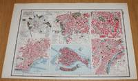
Street Plans of Cities in Italy - Rome (Ancient and Modern), Naples, Venice, Milan and Turin from Harmsworth's 1922 Atlas of the World - Single Sheet
de Edited by J. A. Hammerton; Miss H. B. Leach, H. W. Cribb and J. T. Rankin
- Usado
- Tapa blanda
- Estado
- Usado - Very Good Condition
- Edición
- Early Edition
- Encuadernación
- Paperback
- Cantidad disponible
- 1
- Librería
-
Doncaster, Aberdeen, United Kingdom
- Precio
-
EUR 15.39EUR 17.17 enviando a USA
Mostrar detalles
Descripción:
The Educational Book Co. Ltd, London, 1922. Early Edition. Softcover. Very Good Condition/No Dust Jacket. Single disbound map page from Harmsworth's Atlas of the World and Pictorial Gazetteer. Single sheet only which is divided into 6 panels, plans are in colour and sheet is suitable for framing. Page size is approximately 24.5 x 37cm, actual printed area is approximately 21.5 x 32.5cm. Sheet is clean and bright. Each panel contains a street plan of the central part of the city: Rome Ancient (753BC-475AD with Forum Romanuim, Mons Palatinus and the City Wall); Rome Modern (with Villa Borghese, Botanical Garden,Vatican and St. Peter's, etc); Milan; Naples; Venice (with Giudecca and Cemetary San Michele); Turin. No dust jacket, as published. Undated by publisher. Single sheet map/chart which is suitable for framing . Dated by reference to COPAC/Library Hub Discover. Quantity Available: 1. Shipped Weight: under 1 kg. Pictures of this item not already displayed here available upon request.…
Leer más Precio
EUR 15.39
EUR 17.17
enviando a USA
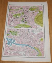
Street Plans of Edinburgh and Glasgow from Harmsworth's 1922 Atlas of the World - Single Sheet
de Edited by J. A. Hammerton; Miss H. B. Leach, H. W. Cribb and J. T. Rankin
- Usado
- Tapa blanda
- Estado
- Usado - Very Good Condition
- Edición
- Early Edition
- Encuadernación
- Paperback
- Cantidad disponible
- 1
- Librería
-
Doncaster, Aberdeen, United Kingdom
- Precio
-
EUR 15.39EUR 17.17 enviando a USA
Mostrar detalles
Descripción:
The Educational Book Co. Ltd, London, 1922. Early Edition. Softcover. Very Good Condition/No Dust Jacket. Single disbound map page from Harmsworth's Atlas of the World and Pictorial Gazetteer. Single sheet only which is divided into 2 panels, plans are in colour and sheet is suitable for framing. Page size is approximately 37 x 24.5cm, actual printed area is approximately 32.5 x 21.5cm. Sheet is clean and bright. Two panels contain street plans for central parts of Edinburgh (including the Castle, Waverley Station, Royal Infirmary, Calton Hill, The Meadows and Holyrood Palace) and Glasgow (including Kelvingrove Park, Queens Dock, Kingston Dock, Cathedral, Buchanan Street Station and Shields Road Station). No dust jacket, as published. Undated by publisher. Single sheet map/chart which is suitable for framing . Dated by reference to COPAC/Library Hub Discover. Quantity Available: 1. Shipped Weight: under 1 kg. Pictures of this item not already displayed here available upon request. Inventory…
Leer más Precio
EUR 15.39
EUR 17.17
enviando a USA

Más fotos
Map of Antarctica - Plate 8 disbound from 1958 Mid-Century Times Atlas of the World using Zenithal Equidistant Projection
de John Bartholomew
- Usado
- Tapa blanda
- Estado
- Usado - Very Good Condition
- Edición
- Mid-Century Edition
- Encuadernación
- Paperback
- Cantidad disponible
- 1
- Librería
-
Doncaster, Aberdeen, United Kingdom
- Precio
-
EUR 33.15EUR 17.17 enviando a USA
Mostrar detalles
Descripción:
The Times Publishing Company Ltd, London, 1958. Mid-Century Edition. Softcover. Very Good Condition/No Dust Jacket. Single disbound map sheet from 'The Times Atlas of the World, Mid-Century Edition; Volume I The World, Australia & East Asia' suitable for framing. Map is in colour and has vertical centre fold. Approx sheet size is 49 x 61cm. Sheet is clean, bright and crisp. Map covers whole of Antarctica and includes Cape Horn, Falkland Islands, Kerguelen Island, South Orkney, South Georgia, South Sandwich Islands, Hobart, South Pole, Ross Ice Sheet, Filchner Ice Sheet, etc. First printing of this edition. Quantity Available: 1. Shipped Weight: under 1 kg. Pictures of this item not already displayed here available upon request. Inventory No: 45021024032. For international tracking please select Priority shipping service..
Precio
EUR 33.15
EUR 17.17
enviando a USA

Más fotos
Map showing World Physiography (Bartholomew's 'Regional' Projection); Vulcanolgy, Structural Geology and Seismology - Plate 1 disbound from 1958 Mid-Century Times Atlas of the World
de John Bartholomew
- Usado
- Tapa blanda
- Estado
- Usado - Very Good Condition
- Edición
- Mid-Century Edition
- Encuadernación
- Paperback
- Cantidad disponible
- 1
- Librería
-
Doncaster, Aberdeen, United Kingdom
- Precio
-
EUR 26.04EUR 17.17 enviando a USA
Mostrar detalles
Descripción:
The Times Publishing Company Ltd, London, 1958. Mid-Century Edition. Softcover. Very Good Condition/No Dust Jacket. Single disbound map sheet from 'The Times Atlas of the World, Mid-Century Edition; Volume I The World, Australia & East Asia' suitable for framing. Map is in colour and has vertical centre fold. Approx sheet size is 49 x 61cm. Sheet is clean, bright and crisp. Sheet contains larger projection of the worlds Vulcanology (after Richey and Kennedy) with Terrestrial Relief, with two smaller maps showing Structural Geology (after Umbgrove and Holmes) and Seismology (after Guttenberg and Richter). First printing of this edition. Quantity Available: 1. Shipped Weight: under 1 kg. Pictures of this item not already displayed here available upon request. Inventory No: 45021024025. For international tracking please select Priority shipping service..
Precio
EUR 26.04
EUR 17.17
enviando a USA
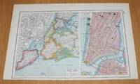
Street Plan of New York (USA) from Harmsworth's 1922 Atlas of the World - Single Sheet with two plans - Greater New York and Central New York
de Edited by J. A. Hammerton; Miss H. B. Leach, H. W. Cribb and J. T. Rankin
- Usado
- Tapa blanda
- Estado
- Usado - Very Good Condition
- Edición
- Early Edition
- Encuadernación
- Paperback
- Cantidad disponible
- 1
- Librería
-
Doncaster, Aberdeen, United Kingdom
- Precio
-
EUR 15.39EUR 17.17 enviando a USA
Mostrar detalles
Descripción:
The Educational Book Co. Ltd, London, 1922. Early Edition. Softcover. Very Good Condition/No Dust Jacket. Single disbound map page from Harmsworth's Atlas of the World and Pictorial Gazetteer. Single sheet only which is divided into 2 panels, plans are in colour and sheet is suitable for framing. Page size is approximately 24.5 x 37cm, actual printed area is approximately 21.5 x 32.5cm. Sheet is clean and bright. Left side of sheet has map of 'New York (Greater)' which covers Richmond, Brooklyn, Manhattan, Queens and Bronx. Right side of sheet has street plan of 'New York (Central)' which is centred on Lower Manhattan and includes Battery Park, Wallabout Bay, City Hall, Washington Square, Tompkins Square, Bellevue Hospital, Madison Square, etc. and has Rail and Ferry routes marked. No dust jacket, as published. Undated by publisher. Single sheet map/chart which is suitable for framing . Dated by reference to COPAC/Library Hub Discover. Quantity Available: 1. Shipped Weight:…
Leer más Precio
EUR 15.39
EUR 17.17
enviando a USA

Más fotos
Map of 'Burma - Thailand - Indo-China' - Plate 24 disbound from 1958 Mid-Century Times Atlas of the World, including Cambodia, Laos, Vietnam, Myanmar and Thailand
de John Bartholomew
- Usado
- Tapa blanda
- Estado
- Usado - Very Good Condition
- Edición
- Mid-Century Edition
- Encuadernación
- Paperback
- Cantidad disponible
- 1
- Librería
-
Doncaster, Aberdeen, United Kingdom
- Precio
-
EUR 33.15EUR 17.17 enviando a USA
Mostrar detalles
Descripción:
The Times Publishing Company Ltd, London, 1958. Mid-Century Edition. Softcover. Very Good Condition/No Dust Jacket. Single disbound map sheet from 'The Times Atlas of the World, Mid-Century Edition; Volume I The World, Australia & East Asia' suitable for framing. Map is in colour and has vertical centre fold. Approx sheet size is 49 x 61cm. Sheet is clean, bright and crisp. Map covers Thailand (Siam), Cambodia, Burma/ Myanmar, Laos, Vietnam and Hainan Tao. Includes are Krung Thep, Saigon, Imphal, Rangoon, Moulmein, Mandalay, Hanoi, Phnom Penh, Chittagong and Vientiane. First printing of this edition. Quantity Available: 1. Shipped Weight: under 1 kg. Pictures of this item not already displayed here available upon request. Inventory No: 45021024048. For international tracking please select Priority shipping service..
Precio
EUR 33.15
EUR 17.17
enviando a USA
Más fotos
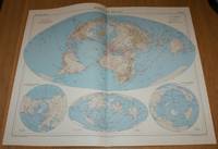
Map showing 'World Air Routes' - Plate 7 disbound from 1958 Mid-Century Times Atlas of the World using Bartholomew's 'Nordic' Projection
de John Bartholomew
- Usado
- Tapa blanda
- Estado
- Usado - Very Good Condition
- Edición
- Mid-Century Edition
- Encuadernación
- Paperback
- Cantidad disponible
- 1
- Librería
-
Doncaster, Aberdeen, United Kingdom
- Precio
-
EUR 29.60EUR 17.17 enviando a USA
Mostrar detalles
Descripción:
The Times Publishing Company Ltd, London, 1958. Mid-Century Edition. Softcover. Very Good Condition/No Dust Jacket. Single disbound map sheet from 'The Times Atlas of the World, Mid-Century Edition; Volume I The World, Australia & East Asia' suitable for framing. Map is in colour and has vertical centre fold. Approx sheet size is 49 x 61cm. Sheet is clean, bright and crisp. Sheet contains four projections or views, one larger and three smaller, of the world and shows Principal and Secondary World Air (aviation) Routes. The three smaller maps show views of North Polar Basin, North Pacific Ocean and The Antipodes. First printing of this edition. Quantity Available: 1. Shipped Weight: under 1 kg. Pictures of this item not already displayed here available upon request. Inventory No: 45021024031. For international tracking please select Priority shipping service..
Precio
EUR 29.60
EUR 17.17
enviando a USA

Más fotos
Map of 'Australia North-East' - Plate 13 disbound from 1958 Mid-Century Times Atlas of the World, including Northern Territory and Queensland with plan of Brisbane
de John Bartholomew
- Usado
- Tapa blanda
- Estado
- Usado - Very Good Condition
- Edición
- Mid-Century Edition
- Encuadernación
- Paperback
- Cantidad disponible
- 1
- Librería
-
Doncaster, Aberdeen, United Kingdom
- Precio
-
EUR 30.78EUR 17.17 enviando a USA
Mostrar detalles
Descripción:
The Times Publishing Company Ltd, London, 1958. Mid-Century Edition. Softcover. Very Good Condition/No Dust Jacket. Single disbound map sheet from 'The Times Atlas of the World, Mid-Century Edition; Volume I The World, Australia & East Asia' suitable for framing. Map is in colour and has vertical centre fold. Approx sheet size is 49 x 61cm. Sheet is clean, bright and crisp. Sheet covers the Northern Territory and Queensland and includes Gulf of Carpentaria, Great Barrier Reef, Alice Springs, Ayers Rock, Arnhem Land, Cairns, Townsville, Rockhampton and Brisbane. Sheet also contains inset plan at closer scale showing Brisbane. Roads and rail routes are shown. First printing of this edition. Quantity Available: 1. Shipped Weight: under 1 kg. Pictures of this item not already displayed here available upon request. Inventory No: 45021024037. For international tracking please select Priority shipping service..
Precio
EUR 30.78
EUR 17.17
enviando a USA

Más fotos
Map of 'Australia South-East' - Plate 12 disbound from 1958 Mid-Century Times Atlas of the World, including South Australia, New South Wales, Victoria, Tasmania with plans of Sydney and Melbourne
de John Bartholomew
- Usado
- Tapa blanda
- Estado
- Usado - Very Good Condition
- Edición
- Mid-Century Edition
- Encuadernación
- Paperback
- Cantidad disponible
- 1
- Librería
-
Doncaster, Aberdeen, United Kingdom
- Precio
-
EUR 30.78EUR 17.17 enviando a USA
Mostrar detalles
Descripción:
The Times Publishing Company Ltd, London, 1958. Mid-Century Edition. Softcover. Very Good Condition/No Dust Jacket. Single disbound map sheet from 'The Times Atlas of the World, Mid-Century Edition; Volume I The World, Australia & East Asia' suitable for framing. Map is in colour and has vertical centre fold. Approx sheet size is 49 x 61cm. Sheet is clean, bright and crisp. Sheet includes South Australia, New South Wales, Victoria, Tasmania and part of Queensland. Sheet contains five inset plans at closer scale showing Sydney, Melbourne, Hobart, Canberra and Adelaide. Roads and rail routes are shown. First printing of this edition. Quantity Available: 1. Shipped Weight: under 1 kg. Pictures of this item not already displayed here available upon request. Inventory No: 45021024036. For international tracking please select Priority shipping service..
Precio
EUR 30.78
EUR 17.17
enviando a USA

Más fotos
Map showing World Vegetation (Winkel's 'Tripel' Projection); Types of Natural Vegetation, Temperature and Land Use - Plate 4 disbound from 1958 Mid-Century Times Atlas of the World
de John Bartholomew
- Usado
- Tapa blanda
- Estado
- Usado - Very Good Condition
- Edición
- Mid-Century Edition
- Encuadernación
- Paperback
- Cantidad disponible
- 1
- Librería
-
Doncaster, Aberdeen, United Kingdom
- Precio
-
EUR 28.41EUR 17.17 enviando a USA
Mostrar detalles
Descripción:
The Times Publishing Company Ltd, London, 1958. Mid-Century Edition. Softcover. Very Good Condition/No Dust Jacket. Single disbound map sheet from 'The Times Atlas of the World, Mid-Century Edition; Volume I The World, Australia & East Asia' suitable for framing. Map is in colour and has vertical centre fold. Approx sheet size is 49 x 61cm. Sheet is clean, bright and crisp. Sheet is divided into four sections with a large projection showing Types of Natural Vegetation and three smaller world maps showing January and July Temperature and Dominant Types of Land Use. First printing of this edition. Quantity Available: 1. Shipped Weight: under 1 kg. Pictures of this item not already displayed here available upon request. Inventory No: 45021024028. For international tracking please select Priority shipping service..
Precio
EUR 28.41
EUR 17.17
enviando a USA
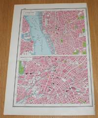
Street Plans of Liverpool and Manchester from Harmsworth's 1922 Atlas of the World - Single Sheet
de Edited by J. A. Hammerton; Miss H. B. Leach, H. W. Cribb and J. T. Rankin
- Usado
- Tapa blanda
- Estado
- Usado - Very Good Condition
- Edición
- Early Edition
- Encuadernación
- Paperback
- Cantidad disponible
- 1
- Librería
-
Doncaster, Aberdeen, United Kingdom
- Precio
-
EUR 15.39EUR 17.17 enviando a USA
Mostrar detalles
Descripción:
The Educational Book Co. Ltd, London, 1922. Early Edition. Softcover. Very Good Condition/No Dust Jacket. Single disbound map page from Harmsworth's Atlas of the World and Pictorial Gazetteer. Single sheet only which is divided into 2 panels, plans are in colour and sheet is suitable for framing. Page size is approximately 37 x 24.5cm, actual printed area is approximately 32.5 x 21.5cm. Sheet is clean and bright. Two panels contain street plans for central parts of Liverpool (including Liver Building, St. George's Hall, Anglican Cathedral, Workhouse, Lime Street Station, Albert Dock, Wallasey Dock, etc.) and Manchester (including London Road, Central, Victoria and Exchange Stations, Corn Exchange, Cathedral, etc.). No dust jacket, as published. Undated by publisher. Single sheet map/chart which is suitable for framing . Dated by reference to COPAC/Library Hub Discover. Quantity Available: 1. Shipped Weight: under 1 kg. Pictures of this item not already displayed here available upon…
Leer más Precio
EUR 15.39
EUR 17.17
enviando a USA

¿No has encontrado lo que estabas buscando?
Prueba a añadir esta búsqueda a búsquedas guardadas Cada día se añaden millones de libros a Biblio. Cuando uno de ellos encaje con tu búsqueda, te enviaremos un correo para avisarte. Y lo mejor de todo, ¡es gratis!
Añadir a búsquedas guardadas

¿Eres un lector habitual o un coleccionista de libros?
Únete al Biblioclub y ahorra 10% en cada compra, ¡cada día! Hasta un máximo de 20$ en cada pedido

Responsabilidad social
¿Sabías que desde 2004 Biblio ha destinado sus beneficios a la construcción de 16 bibliotecas públicas en zonas rurales de Latinoamérica?
