Descripción:
Weimar: Verlag des Industrie Compotoirs, 1803. The right half of the leaf is spotted throughout. Otherwise in good condition.. 42.7 x 47,8 cm (16.75 x 18,75 inches).. Original antique copper engraving, hand colored in outline and wash when published. Handcolored copperengraving map of the southern part of West Africa. It covers the region from the Sahara in the north to Camma in the south, from the ocean in the west to Agades in the east. The map focuses on the coastal regions and the cities along the rivers in the west. At the bottom left is the title cartouche, above it a small inset map of the Capoverde Islands, to the right of which are the scales in geographical miles and nautical miles.
Resultados de búsqueda: Libros de Antiquariat Reinhold Berg ek
Has buscado:
- Librería: Antiquariat Reinhold Berg ek
Resultados: 1 - 16 de 16

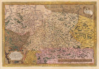
Charte von Senegambien, Nigritien und Guinea Nach den neuesten See- und Land- Reisen und astronmischen Beobachtungen gezeichnet von I.C.M. Reinecke. Weimar
de Reinecke, I.C.M.
- Usado
- Estado
- Usado
- Cantidad disponible
- 1
- Librería
-
Regensburg, Germany
- Precio
-
EUR 142.17EUR 22.60 enviando a USA
Mostrar detalles
Precio
EUR 142.17
EUR 22.60
enviando a USA

Charte von Nieder Guinea und den angrenzenden Ländern Süd Afrika´s nach den neuesten und besten Hülfsmitteln gezeichnet von I.C.M. Reinecke. Weimar
de Reinecke, I.C.M.
- Usado
- Estado
- Usado
- Cantidad disponible
- 1
- Librería
-
Regensburg, Germany
- Precio
-
EUR 199.60EUR 22.60 enviando a USA
Mostrar detalles
Descripción:
Weimar: Verlag des Industrie Compotoirs, 1801. The right half of the leaf is spotted throughout. Otherwise in good condition.. 42.7 x 47,8 cm (16.75 x 18,75 inches).. Original antique copper engraving, hand colored in outline and wash when published. Original antique map of the Lower Guinea and the individual kingdoms. Apparently not much was known about this area at the time of writing, only the coastline, the Congo and some apparently Spanish-occupied areas in the east with gold and silver mines are shown in the usual detail. The title cartouche is at the bottom left.
Precio
EUR 199.60
EUR 22.60
enviando a USA

Circulus Saxoniae, Inferioris in quo sunt Ducatus Holsatiae, Meklenburgi, Lauwendurgi, Luneburgi, Brunsuigi, Bremae et Ferdae, Comitatus Dannebergi, Archiepiscopatus Maegdenburgensis, Episcopatus Hildesiae et Halberstad Per F. de Wit.
de de Wit, Frederic
- Usado
- Estado
- Usado
- Cantidad disponible
- 1
- Librería
-
Regensburg, Germany
- Precio
-
EUR 205.25EUR 22.60 enviando a USA
Mostrar detalles
Descripción:
Amsterdam: de Wit, 1680. Trimmed top and bottom. Sheet browned throughout. Small corner tear at bottom right, outside the illustration. Two small brown spots at the bottom left of the leaf edge. Some small creases on the center fold.. 495 by 575mm (19½ by 22¾ inches).. 495 by 575mm (19½ by 22¾ inches).. Original antique copper engraving. This antique map shows us lower Saxony in Germany. Inside the map are also the neighbouring regions engraved as Westfalia, Luneburg, Meklenburg, Bremen, etc. In the right lower corner we found the figurative title cartouche. The figuratives hold the singles coast of arms from the singles regions. In the left lower corner we see also a figurative title cartouche with the mileage scale.
Precio
EUR 205.25
EUR 22.60
enviando a USA

Hier wird das Meisterstück im Bauen vorgestellt, bedenkt die große kunst, Müh, Werkzeug, Zeit und Geld. Als man auff festem Grund ein Brücken=Werck vollführet, das Sturm und Fluthen trotzt, auch große Städte zieret; Im Buche selber wird dem Leser vorgelegt, Was Ost, West, Süd und Nord vor rare Brücken heegt.
de Dresde
- Usado
- Estado
- Usado
- Cantidad disponible
- 1
- Librería
-
Regensburg, Germany
- Precio
-
EUR 227.84EUR 22.60 enviando a USA
Mostrar detalles
Descripción:
Dresden: I. A. Richter, 1735. Blatt gebräunt, im Bereich der Kartusche einige kleine braune Flecken. Ansonsten in gutem Zustand.. 32.5 x 40 cm (12.75 x 15,75 inches).. Original antiker Kupferstich, unkoloriert. Erschienen bei Schramm,Historischer Schauplatz: in welchem die merkwürdigsten Brücken aus allen vier theilen der Welt, insonderheit aber die in den vollkommensten Stand versetzte Dressdner Elb-brücke, in saubern Prospecten, münzen und andern Kupferstichen, vorgestellet und beschrieben werden, 1735. Blick auf Dresden mit der neuen Augustusbrücke, im Vordergrund das Reiterstandbild Augusts des Starken. Mit Allegorischer Titelkartusche. „Hier wird die Meisterleistung des Bauens präsentiert... u. einige Bauszenen. Ursprünglich war die Augustusbrücke das größte Brückenbauwerk des deutschen Hochmittelalters und eines der größten mittelalterlichen Verkehrsbauwerke Europas. Unter August dem Starken wurde die Brücke von Matthäus Daniel Pöppelmann grundlegend umgestaltet.
Precio
EUR 227.84
EUR 22.60
enviando a USA

Repraesentationem Circuli Saxonici Inferioris
de Homann Heirs
- Usado
- Estado
- Usado
- Cantidad disponible
- 1
- Librería
-
Regensburg, Germany
- Precio
-
EUR 227.84EUR 22.60 enviando a USA
Mostrar detalles
Descripción:
Nürnberg, 1784. In excellent condition.. 48.3 x 52 cm (19 x 20,5 inches).. Old colored copperplate engraving after F. L. Güssefeld by Homann Erben, 1784. With French head title ("Representation de Cercle de Bas-Saxe") This antique map shows all of Lower Saxony, Brandenburg and Mecklenburg, as well as part of Holstein. - Title cartouche at the bottom right, cartouche with mile marker on the left. Header title in French.
Precio
EUR 227.84
EUR 22.60
enviando a USA

Oberpfalz Nordgau Delineatio Nordgoviae Veteris prout ejus facies Seculo XI. & XII. suit, Geographice designata per Iohannem Henricum de Falckenstein C.A.B.O. ac in lucem emisa sumtibus Homannianorum Heredum Norib. 1733
de Homann, J.B. (Homann Heirs)
- Usado
- Estado
- Usado
- Cantidad disponible
- 1
- Librería
-
Regensburg, Germany
- Precio
-
EUR 313.52EUR 22.60 enviando a USA
Mostrar detalles
Descripción:
Nürnberg: Homann Heirs, 1733. Other. Published plano without a centre fold. In excellent condition. 455 by 554mm (18 by 21 inches).. 455 by 554mm (18 by 21 inches).. Original antique copper engraving in full contemporary hand color in wash and outline when published. In the right corner of the picture there is a title cartouche with a floral border in the middle, as well as an inset card with the Fossa Carolina near Dietfurt a.d. at the top right. Altmühl. Historical map of the Nordgau based on the drawing by Johann Heinrich v. Falkenstein. Johann Baptist Homann (20 March 1664 1 July 1724) was a German geographer and cartographer, who also made maps of the Americas.
Homann was born in Oberkammlach near Kammlach in the Electorate of Bavaria. Although educated at a Jesuit school, and preparing for an ecclesiastical career, he eventually converted to Protestantism and from 1687 worked as a civil law notary in Nuremberg. He soon turned to engraving and cartography; in 1702 he founded his own…
Leer más Precio
EUR 313.52
EUR 22.60
enviando a USA
Typus Geographicus Ducat. Lauenburgici Novus in sua Praefaecturas ope probatorum documentorum divisus insuperque Parergo Historico dediversis illius ab Henrici Leonis usqu ad hae tempora Acminy Periodis adoratus et delineatus a Ioh. Bapt. Homanni S.C.M. Geogr. Filio Noribergae cum Priv. Sac. Caes. ut & Reg. Maj. Polon Anno D MDCCXXIX
de Homann, Johann Baptist
- Usado
- Estado
- Usado
- Cantidad disponible
- 1
- Librería
-
Regensburg, Germany
- Precio
-
EUR 319.17EUR 22.60 enviando a USA
Mostrar detalles
Descripción:
Nürnberg: Homann, 1729. In excellent condition. 565 by 477mm (22 by 18 inches).. 565 by 477mm (22 by 18 inches).. Original antique copper engraving, hand colored in outline and wash when published. Detailreiche Karte des Gebietes östlich von Hamburg, ehemaliges Herzogtums Sachsen-Lauenburg. Oben links eine Insetkarte des Landes Hadeln. Es handelt sich hierbei um eine historische Landschaft an der unteren niedersächsischen Elbe. Unten links die prachtvolle unkolorierte Titelkartusche mit zahlreichen Allegorien. Im Zentrum der Darstellung der Titel eingraviert auf einen Sockel. Die Göttin Pax zeigt neben ihren Attributen verschiedene Wappen, unter anderem des Hauses Braunschweig-Lüneburg. Unter ihr die Darstellung einer Schlacht. Im linken unteren Eck ist Heinrich der Löwe in Rüstung mit einem Löwen eingraviert. Am rechten Bildrand ein von einem Putti getragener Meilenzeiger.
Detailed map of the area east of Hamburg, former Duchy of Saxony-Lauenburg. An inset map of the country of…
Leer más Precio
EUR 319.17
EUR 22.60
enviando a USA

Der nördliche Theil des Obersächsischen Kreises oder die Mark Brandenburg und das Herzogthum Pommern aufs neue entworfen durch F.L.G. und ans Licht gestellet von den Homan. Erben. 1780. Mit Kaiserl. Allgn. Privilegio.
de Homann, J.B. (Homann Heirs)
- Usado
- Estado
- Usado
- Cantidad disponible
- 1
- Librería
-
Regensburg, Germany
- Precio
-
EUR 341.76EUR 22.60 enviando a USA
Mostrar detalles
Descripción:
Nürnberg: Homann, J. B. (Homanns Heirs), 1780. In very good condition and in full original colors. Small wormhole at the bottom of the center fold. Some waterstains.. 46 x 57,4 cm (18 x 22,5 inches).. Original antique copper engraving in full contemporary hand color in wash and outline when published. The map shows the March of Brandenburg and the Duchy of Pomerania. On the right is the title cartouche, including three-column explanations. At the top left there is a legend about the different sized places and below the mile marker. On the left below the border line with the engraver's signature "I.M. Schmidt sc. Nor." The very decorative map replaces the map "Tabula Marchionatus Brandenburgici Et Ducatus Pomeraniae.", which was published by Homann more than 50 years earlier.
Precio
EUR 341.76
EUR 22.60
enviando a USA

Doesbourg
de Chatillon, Ludwig de
- Usado
- Estado
- Usado
- Cantidad disponible
- 1
- Librería
-
Regensburg, Germany
- Precio
-
EUR 433.09EUR 22.60 enviando a USA
Mostrar detalles
Descripción:
Netherland: Le Clerc
, 1676. Mounted on thick paper. In excellent condition.. 42 x 35,5 cm (16.5 x 14 inches).. Original antique engraving. Bird's-eye view of the Battle of Doesburg in the Netherlands in 1672. Detailed engraving of the battle surrounded by an ornate Baroque border with armor, axes, spears and arrows. Above the depiction in a round border is a plan with the city wall of Doesbourg. On either side, scantily clad angels with fanfares. French text underneath.
Precio
EUR 433.09
EUR 22.60
enviando a USA
Saxoniae Misniae, Thuringiae, Nova Exactissimaq Descriptio.
de Ortelius, Abraham
- Usado
- Estado
- Usado
- Cantidad disponible
- 1
- Librería
-
Regensburg, Germany
- Precio
-
EUR 455.69EUR 22.60 enviando a USA
Mostrar detalles
Descripción:
Antwerpen, 1584. In excellent condition. . 345 by 503mm (13½ by 19¾ inches).. Original antique copper engraving, colored in outline and wash when published. Latin text edition. The map image shows Thuringia and Saxony, as well as Upper and Lower Lausnitz. Very nice uncolored copy, published in the first Spanish edition of the Theatrum Orbis Terrarum by A. Ortelius. Flawless copy, even and strong impression. Broe. 93
Precio
EUR 455.69
EUR 22.60
enviando a USA

Das alte Schloß Karlsbad in Böhmen Chrudimer-Kreis
de Postl, C.
- Usado
- Estado
- Usado
- Cantidad disponible
- 1
- Librería
-
Regensburg, Germany
- Precio
-
EUR 547.01EUR 22.60 enviando a USA
Mostrar detalles
Descripción:
Wien: Artaria & Comp., 1810. Sheet browned throughout. Very wide margins. Small hole outside the image. Sheet 48,5x61,5 cm.. 29 x 43 cm (11.5 x 17 inches).. Old colored outline etching by Carl Postl after Laurenz Janscha from "Collection des vues les plus interestinges et picturesques de la Boheme", around 1810. Decorative panoramic view of Karlsbad in Bohemia. The etching was engraved by C. Postl after a sketch by Lorenz Jantscha. Printed on handmade paper, with watermark,van Gelder Zonen.
Precio
EUR 547.01
EUR 22.60
enviando a USA

Ansicht von Karlsbad in Böhmen
de Postl, C.
- Usado
- Estado
- Usado
- Cantidad disponible
- 1
- Librería
-
Regensburg, Germany
- Precio
-
EUR 547.01EUR 22.60 enviando a USA
Mostrar detalles
Descripción:
Wien: Artaria & Comp., 1810. Sheet browned throughout. Very wide margins. Sheet 46x57,5 cm.. 29 x 43 cm (11.5 x 17 inches).. Old colored outline etching by Carl Postl after Laurenz Janscha from "Collection des vues les plus interestinges et picturesques de la Boheme", around 1810. Decorative panoramic view of Karlsbad in Bohemia. The etching was engraved by C. Postl after a sketch by Lorenz Jantscha. Printed on handmade paper, with watermark,van Gelder Zonen.
Precio
EUR 547.01
EUR 22.60
enviando a USA
Novissima et accuratissima Magni Ducatus Lithuaniae in suos Palatinaus et Castellanias divisae Delineatio...
de Seutter, Matthäus
- Usado
- Estado
- Usado
- Cantidad disponible
- 1
- Librería
-
Regensburg, Germany
- Precio
-
EUR 627.04EUR 22.60 enviando a USA
Mostrar detalles
Descripción:
Augsburg: Tobias Conrad Lotter, 1730. Some old restored repairs.
. 49.7 x 57,3 cm (19.5 x 22,5 inches).. Original antique copper engraving, hand colored in outline and wash when published. Very rare antique map of Lithuania. This is the second edition with the Seutter privilege added at top right corner. Decorative cartouche with hand colored coat of arms with crown above. Matthäus Seutter (born September 20, 1678 in Augsburg; March 1757 there) was a German cartographer and engraver as well as the founder of the Seutter printing company and publishing house.
Born the son of a goldsmith, Seutter began an apprenticeship with Johann Baptist Homann in Nuremberg after 1697. Returning to his hometown of Augsburg, he initially worked in the publishing house of Jeremias Wolff (16631724).
Around 1707 he founded his own company with a printing and publishing house. There he produced large numbers of maps, city maps, genealogical diagrams and other motifs. He also brought out a pair of globes…
Leer más Precio
EUR 627.04
EUR 22.60
enviando a USA
Territorii Novoforensis in Superiore Palatinatu Accurata Descriptio...
de Janssonius, Joan
- Usado
- Estado
- Usado
- Cantidad disponible
- 1
- Librería
-
Regensburg, Germany
- Precio
-
EUR 683.53EUR 22.60 enviando a USA
Mostrar detalles
Descripción:
Amsterdam: Joannes Janssonius, 1640. In excellent condition.. 42.5 x 55 cm (16.75 x 21,75 inches).. Original copperplate map in contemporary border and surface color, published in the Atlas Major by Joan & Guiljemus Blaeu in Amsterdam, engraved based on the map image by Nikolaus Rittershaus. The Neumarkt area is shown in detail. The individual areas are highlighted by 16 painted coats of arms. Here is the edition by G. Blaeu (from 1660) with the cartouche for hunting. Impeccable in a magnificent contemporary color. Koeman [2680:1.1]
Precio
EUR 683.53
EUR 22.60
enviando a USA

Zee-kaarte van de Golf van Venetien...
de Goos, Pieter
- Usado
- Estado
- Usado
- Cantidad disponible
- 1
- Librería
-
Regensburg, Germany
- Precio
-
EUR 854.88EUR 22.60 enviando a USA
Mostrar detalles
Descripción:
Amsterdam: Pieter Goos, 1660. In very good to excellent condition. . 40 x 52 cm (15.75 x 20,5 inches).. Original antique copper engraving, finely hand colored in outline, when published. Partially heightened in gold. Rare sea map of the Adriatic with the coasts of Italy (north of Otranto) as well as Croatia (La Valona), Montenegro and Albania. The cartouche and the entire coastline were heightened in gold. There are some mileage scales in the bottom left corner. The towns on the coast were marked with small red castles. Pieter Goos was 'one of the best known maritime booksellers of Amsterdam' (Koeman), he published a number of different sea-atlases or pilot books, his work was very much derivative. With his 'Zee-Atlas' he relied heavily on Hendrick Doncker's 'Zee-Atlas' of 1659. Our example of Pieter Goos chart 'Paskaerte Zynde t'Oosterdeel van Oost Indien...' was published in an early composit sea-atlas published probably around 1665/66. This map is printed on excellent thick double paper, it…
Leer más Precio
EUR 854.88
EUR 22.60
enviando a USA

L´Asie diviseé em ses Principales Regions, et ou se peuvent voir l´estendu des Empires Monachies,Royaumes, et Estats qui partagent presentement L´Asie.
de Jaillot, Alexis-Hubert & Mortier, Pierre
- Usado
- Estado
- Usado
- Cantidad disponible
- 1
- Librería
-
Regensburg, Germany
- Precio
-
EUR 962.21EUR 22.60 enviando a USA
Mostrar detalles
Descripción:
Amsterdam: P. Mortier, 1719. Small tear outside the image. Restored tear on the center fold, else in very good condition.. 45.8 x 64,5 cm (18 x 25,5 inches).. Original antique copper engraving, hand colored in outline.A fine example of a strong impression of this very large map. This issue is published and printed at Pierre Mortier in Amsterdam 1705. This large map, printed from two plates, was first published in the Atlas Noveau... by Alexis Hubert Jaillot & N. Sanson. The area extends from Italy in the west of the map to New Guinea in the east. In the right upper corner ornated with a large highly decorative allegoric title-cartouche. This large map by the French cartographer Alexis-Hubert Jaillot impresses by its details in place names, engraved mountains and rivers. Hubert Jaillots map can be treated as a masterpiece of the French baroque cartography in the 17th century. It took Nicolaus Sanson and Hubert Jaillot a period of about fifteen years to complete this enormous work (c.…
Leer más Precio
EUR 962.21
EUR 22.60
enviando a USA

¿No has encontrado lo que estabas buscando?
Prueba a añadir esta búsqueda a búsquedas guardadas Cada día se añaden millones de libros a Biblio. Cuando uno de ellos encaje con tu búsqueda, te enviaremos un correo para avisarte. Y lo mejor de todo, ¡es gratis!
Añadir a búsquedas guardadas

¿Eres un lector habitual o un coleccionista de libros?
Únete al Biblioclub y ahorra 10% en cada compra, ¡cada día! Hasta un máximo de 20$ en cada pedido

Responsabilidad social
¿Sabías que desde 2004 Biblio ha destinado sus beneficios a la construcción de 16 bibliotecas públicas en zonas rurales de Latinoamérica?
