Descripción:
Boston & New York: Weeks, Jordan & Co., and Wiley & Putnam, 1838. Twenty inch elephant folio, expertly re-backed with original half-leather boards, with original spine laid down on a new Harmatan goatskin spine, some restoration to corners of covers. Front endpapers creased (original), with two title pages (first in full color). Few maps expertly repaired verso (minor tears at margins; none major). An owner's inscription indicating a gift to a son, dated 1860, is on the verso of the Philadelphia frontis plan. This was an enlarged edition (including a larger map format) of Bradford's eariler atlas. Wiley & Putnam were the New York publishers; Weeks, Jordan and C. were of Boston. The atlas was stereotyped and printed by Fulsom, Wells & Thurston of Cambridge, Mass. Ristow (p. 271 "American Maps and Mapmakers") indicates that the title page was engraved by James Archer of Boston, also repsonsible for most of the plates in Hinton's "History and Topography of…
Leer más Resultados de búsqueda: Libros de The Prime Meridian: Antique Maps & Books
Has buscado:
- Librería: The Prime Meridian: Antique Maps & Books
Resultados: 1 - 20 de 1493

(39 Maps / City Plans): An Illustrated Atlas, Geographical Statistical, and Historical, of the United States, and the adjacent Countries
de Bradford, T.G. (Thomas Gamaliel)
- Usado
- Tapa dura
- First
- Estado
- Usado
- Edición
- First Thus
- Encuadernación
- Hardcover
- Cantidad disponible
- 1
- Librería
-
Crozet, Virginia, United States
- Precio
-
EUR 7,727.20EUR 7.94 enviando a USA
Mostrar detalles
Precio
EUR 7,727.20
EUR 7.94
enviando a USA
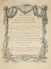
(History of Cartography, Geographic description of the Antilles): Description geographique des isles Antilles possédées par les Anglois
de Bellin, Jacques Nicolas
- Usado
- very good
- Tapa dura
- First
- Estado
- Usado - Very Good
- Edición
- First Edition
- Encuadernación
- Hardcover
- Cantidad disponible
- 1
- Librería
-
Crozet, Virginia, United States
- Precio
-
EUR 7,073.54EUR 7.94 enviando a USA
Mostrar detalles
Descripción:
A Paris: De l'imprimerie de Didot, 1758. This 10.5 inch quarto is in very good condition, sound hinges, 171 pp. with all 22 maps (several folding), plans and views in very good or better condition on heavy paper. Contemporary calf boards with original marbeled pastedowns, two title pages (one decorative with attribution to Bellin), "Tables des Titres" and "Table des Cartes, Plans et Vues." Six compartment, banded spine, with red, gilt title label.Triple (French), gilt fillets on front and rear boards. Bellin was the first chief hydrographic engineer of the French Hydrographic Office (see Tooley's Dictionary of Mapmakers, revised ed.). Ref: Beinecke, Lesser Antilles Collection, 215; Sabin 4553. This is an extremely nice copy.. First Edition. Full-Leather. Very Good.
Precio
EUR 7,073.54
EUR 7.94
enviando a USA
(History of Military Cartography- 31 plans, Frederick the Great): Secret Strategical Instructions, of Frederic the Second, for His Inspectors General, Translated from the German,
de Smith, Captain C. H. (Charles Hamilton)
- Usado
- very good
- First
- Estado
- Usado - Very Good
- Edición
- First Thus
- Cantidad disponible
- 1
- Librería
-
Crozet, Virginia, United States
- Precio
-
EUR 6,139.74EUR 7.94 enviando a USA
Mostrar detalles
Descripción:
London: Printed for the Author (Sold Also By Longman , Hurst, Rees, Orme, and Brown, and others), 1811. Very good, all 31 hand colored, engraved maps / plans with the separate textual explanations of each plate (complete as issued). x, 28, (31) (plus the errata slip bound between the text and plates).This is an 11 inch 4to, in a contemporary red, full morocco presentation binding, with the recipient's name in gilt on the covers (Lieut. Genl. Robert Brownrigg..). Very slight scuffing, binding tight, a.e.g., with Brownrigg's armorial bookplate on the front pastedown. This is a very scarce item (online copies at Library of Congress, British Library, Duke, Princeton, New York Public Library, US Army Military History Institute, Staatsbibliothek zu Berlin). According to the DNB, Smith was a soldier-scholar, published naturalist, and contributor to the Encyclopedia Britannica. His preface indicates that London publisher declined to produce the work at their expense, in part becasue of the costs of…
Leer más Precio
EUR 6,139.74
EUR 7.94
enviando a USA
(60 maps / plates): A New General Atlas, Comprising a Complete Set of Maps, representing the Grand Divisions of the Globe, Together with the several Empires, Kingdoms and States in the World: Compiled from the Best Authorities
de Finley, Anthony (written and engraved by Jos. Perkins)
- Usado
- very good
- Tapa dura
- First
- Estado
- Usado - Very Good
- Edición
- First Edition
- Encuadernación
- Hardcover
- Cantidad disponible
- 1
- Librería
-
Crozet, Virginia, United States
- Precio
-
EUR 5,952.97EUR 7.94 enviando a USA
Mostrar detalles
Descripción:
Philadelphia: Anthony Finley, 1824. Small folio, 13.75 inches, very good condition, half leather with some resoration to spine. Front endpaper detached but present. Very little foxing, few tiny stains, to the 58 hand colored maps and two charts (mountains, rivers). Sixty plates in all, as called for (Phillips 4314). The maps were engraved by Young and Delleker, who did many of the maps for many other period atlases, including those of the Carey and Lee atlases, also of Philadelphia. This is the first edition, second issue (Western Hemisphere is first map) of this well-known atlas. The individual states of America are all here, along with other world areas, with each individual engraving measuring approximately 11.5 x 8.5 inches. There is a small owners signature (Mary G. Chow ?) penned at the left lower title page. This is a nice atlas from the early USA, at a time when most of the production centered in Philadelphia. A rather scarce atlas in this early state. LC Control Number: unk82073490 . . First…
Leer más Precio
EUR 5,952.97
EUR 7.94
enviando a USA
(Map of North and South America- All 6 Sheets): A Chart of North and South America, Including the Atlantic and Pacific Oceans, Including the Nearest Coasts of Europe, Africa, and Asia
de Jefferys, Thomas
- Usado
- Estado
- Usado
- Cantidad disponible
- 1
- Librería
-
Crozet, Virginia, United States
- Precio
-
EUR 4,272.14EUR 7.94 enviando a USA
Mostrar detalles
Descripción:
London: Robt. Sayer J. Bennett, No. 53 in Fleet St. , 1775. VG, scarce, striking chart. B&W as issued, mild general soiling, a couple of small stains, with a few small marginal tears (none over neatline) repaired verso with archival tape. Folds as issued. This is an enormous map, issued as 6 sheets (in this case 3 sheets, but each of those is a joined pair), with each of the 3 larger sheets measuring 43.5x18 inches (for a total image of 43.5x54 inches). Original outline color, with each sheet having its own heading. The first sheet is titled as the map. The second sheet is titled 'Chart, Containing the coasts of California, New Albion, and Russian Discoveries...'. The third sheet is 'Chart containing the greater part of the South Sea...'. On heavy paper, with a small stamp from the Free Library of Chester on verso. Detailed and relatively decorative for the times, with sailing ships showing major known routes of exploration (with the names of the explorers) to the Americas. This…
Leer más Precio
EUR 4,272.14
EUR 7.94
enviando a USA
(Map/Chart NE Coast USA, New England): Carte réduite des côtes orientales de l'Amérique septentrionale. Contenant celles des provinces de New-York et de la Nouvelle Angleterre, celles de l'Acadie ou Nouvelle Ecosse, de I'&I
de Sartine (Antoine de, comte d'Alby)
- Usado
- Estado
- Usado
- Cantidad disponible
- 1
- Librería
-
Crozet, Virginia, United States
- Precio
-
EUR 4,202.10EUR 7.94 enviando a USA
Mostrar detalles
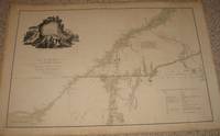
Descripción:
Paris: Dépôt des cartes et plans de la Marine, 1780. Near fine, large, striking chart of New England area, from the French Hydrographic Office of the time. Early hand color, No. 163 on upper right corner, "Petit Sculp." lower left, "Prix Trois Francs" lower right. The paper is heavy and clean, with nice margins, and the impression is very clear. Elaborate depth soundings, with little inland detail. According to McCorkle (New England, entry 780.3) this map was issued both as part of "Neptune Americo-Septentrionale" in 1780 and as a separate map. Our variant differs slightly from those in OCLC (added ref: Sellers and van Ee, 215-216). The above date is approximate. The image measures 58 x 86 cm (23 x 34 inches).. Map.
Precio
EUR 4,202.10
EUR 7.94
enviando a USA
(Maps, Western Canada): Index to Captain Palliser's Reports, showing the date of each journey, the route, and the page in which it is described in the copies of the reports laid before Parliament on the 19th May 1863
de Palliser, John
- Usado
- very good
- Tapa blanda
- First
- Estado
- Usado - Very Good
- Edición
- First Edition Thus
- Encuadernación
- Paperback
- Cantidad disponible
- 1
- Librería
-
Crozet, Virginia, United States
- Precio
-
EUR 3,618.48EUR 7.94 enviando a USA
Mostrar detalles
Descripción:
London: Printed by George Edward Eyre and William Spottiswode, Printers to the Queen's Most Excellent Majesty, for Her Majesty's Stationery Office., 1865. This is just the index with the five folding maps, all in very good or better condition. The bluish-green paper covers are nearly separated at the spine, but generally clean and legible. There is a handwritten signature of Robert Bell, who was the director of the Geological Survey of Canada, a charter member of the Royal Society of Canada. John Palliser was a geographer and explorer (see Oxford Dictionary of National Biography). He was awarded the patron's gold medal of the Royal Geographical Society in 1859. Most of these maps were done by John Arrowsmith, but the imprint on the maps is from Stanford's Geographical Establishment, London. The five folding maps are: 1. A general map of the routes in British North America explored by the expedition under Captain Palliser, during the years 1857, 1858, 1859, 1860. . .(large , printed…
Leer más Precio
EUR 3,618.48
EUR 7.94
enviando a USA
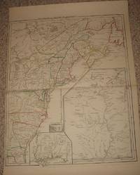
(Revolutionary War Era): A map of the inhabited part of Canada from the French surveys; wiith the frontiers of New York and New England from the large surveys
de Sauthier, Claude Joseph
- Usado
- very good
- First
- Estado
- Usado - Very Good
- Edición
- First Edition Thus
- Cantidad disponible
- 1
- Librería
-
Crozet, Virginia, United States
- Precio
-
EUR 3,548.44EUR 7.94 enviando a USA
Mostrar detalles
Descripción:
London: Wm. Faden, 1777. Very good, minimal wash color as issued, with remarks indicating the survey order of Genr. Pownall. This uncommon map relates to the invasion of Canada. A few small archival taped repairs in margin verso. Heavy paper, very ittle browning This is the later state (2nd), with the dedication to Major General John Burgoyne, and the table of the "Winter Quarters of the Kings Army in Canada..." Below the cartouche: London, Published as the Act directs, Feby. 25. 1777 by Wm. Faden, Corner of St. Martin's Lane, Charing Cross. Ref: McCorckle, New England in Early Printed Maps, entry 777.19; Nebenzahl, entry 43. Folds as issued. Image measures 57 x 85 cm (22.5 x 33. 5 inches).. First Edition Thus. Very Good. Map.
Precio
EUR 3,548.44
EUR 7.94
enviando a USA
(Map, Revolutionary War Era, Colonial America): Theatre de la Guerre en Amerique
de Le Rouge, George Louis
- Usado
- very good
- Estado
- Usado - Very Good
- Cantidad disponible
- 1
- Librería
-
Crozet, Virginia, United States
- Precio
-
EUR 3,361.68EUR 7.94 enviando a USA
Mostrar detalles
Descripción:
Paris: le Rouge, 1777. Very good/excellent, hand colored outlines, trimmed a bit close at margin (due to binding in prior Le Rouge atlas, "Atlas Ameriquain Septentrional..."). Image measuring 62 x 50 cm (24 x 20 inches). This is a clean impression on heavy paper. Three insets: Louisiane, southeast coastal region (Floride), Sault du Niagra. "Par le Sr. le Rouge, ingenieur geographe du Roy." appears after title in upper margin. This is McCorkle entry 777.14, without the "Corrigee...M. Hawkins...". Apparently Le Rouge reworked his early map (Canada et Louisane..) of 1755, and changed the title for this work (McCorkle entry 755.23). Not in Nebenzahl, although several other maps from this atlas appear in the references. The map is cataloged in OCLC. . Very Good. Map.
Precio
EUR 3,361.68
EUR 7.94
enviando a USA

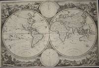
(World Map): Planiglobii terrestris mappa universalis utrumq hemisphærium orient. et occidentale repræsentans ex IV mappis generalibus (Mappe-monde qui represente les deux hemispheres savoir celui de l'orient et celui de l'occident ...
de Homann Heirs (Johann Matthias Hase; G M Lowitz)
- Usado
- Estado
- Usado
- Cantidad disponible
- 1
- Librería
-
Crozet, Virginia, United States
- Precio
-
EUR 2,754.71EUR 7.94 enviando a USA
Mostrar detalles
Descripción:
Nuremberg: Homann Heirs, 1746. Very good, heavy paper, early color, dual hemisphere world map. This is rather decorative, with the four additional smaller polar spheric projections on the map, and two diagrams relating to the position of the sun. Each of the main hemispheric images is 27 cm in diameter, with the full image measuring 46 x 54 cm, on sheet measuring 52 x 62 cm. This is a strong impression, with the cartouches uncolored, as issued. Titles in Latin and French. Two extra printers creases in upper margin; very small portion of right lower corner missing (well outside platemark and neatline). Old 1 cm taped repair to verso of lower margin. Centerfold as issued. .
Precio
EUR 2,754.71
EUR 7.94
enviando a USA
(World Map from Keur bible): Wereldkaart
de Jagen, Jan Van
- Usado
- very good
- Estado
- Usado - Very Good
- Cantidad disponible
- 1
- Librería
-
Crozet, Virginia, United States
- Precio
-
EUR 2,754.71EUR 7.94 enviando a USA
Mostrar detalles
Descripción:
Dordrecht: Keur, 1748. Very good double hemisphere world map from a Keur bible, b&w as issued. The engraver/designer for this map was J. v. Jagen (sculps. et dir.; engraved on lower central edge of plate just inside neatline). Folds as issued. Two smaller spheres upper (Polus Arcticus) and lower (Polus Antarcticus) center. The majority of place names and verso text are in Dtuch. The decorative allegorical surrounds are quite nice. The map image measures 30 x 45 cm, with the diameter of each hemisphere measuring 22 cm. The Keur family were active bible publishers from the mid 17th to mid 18th centuries. This particular map corresponds to variant K III, entry 137, p. 205 in Poortman and Augusteijn's "Kaarten in Bijbels..." The map date is approximate. There is no recto title banner for this issue.. Very Good. Map.
Precio
EUR 2,754.71
EUR 7.94
enviando a USA
(Map / Chart of North and South America- California as an Island)): Recentissima Novi Orbis Sive Americae Septentrionalis et Meridionalis Tabula Per I. Danckerts..cum Privilegio
de Danckerts (Danckaerts,danckers, Danquerts), Justus
- Usado
- First
- Estado
- Usado
- Cantidad disponible
- 1
- Librería
-
Crozet, Virginia, United States
- Precio
-
EUR 2,614.64EUR 7.94 enviando a USA
Mostrar detalles
Descripción:
Amsterdam: J. Danckerts, 1696. Very good, early color with minor archival verso repairs to centerfold (expert). This is a very decorative image of the Americas with the California as an island format, and a decorative cartouche of natives, serpents. It is no accident that the cartouche design and imagery on these maps strongly resemble those of the Blaeus, as Danckerts borrowed liberally from his predecessor. The Solomon Islands are shown to the west., as are the Cape Verde, Fortunate and Azores to the east. The Danckerts were a multigenerational and prominent mapmaking family in Amsterdam. This is plate 1 from an atlas, depicting the western hemisphere with elaborate detail for the times. Much of the southeastern USA is then labelled as Florida, with the Mare Virginicum and Canadium notations present. This uncommon and handsome image (map #2, vol. II of Koeman's 1st edition "Atlantes Neerlandici"), with minimal browning, measures 19x23 inches (49x58cm). .
Precio
EUR 2,614.64
EUR 7.94
enviando a USA

(Celestial chart, lunar orbits and eclipses): Theoria Lunae, Eius Motum Per Eccentricum Et Epicyclum Demonstrans
de Valk, Gerard and Schenk, Petrus [Cellarius, Andreas]
- Usado
- Estado
- Usado
- Cantidad disponible
- 1
- Librería
-
Crozet, Virginia, United States
- Precio
-
EUR 2,497.92EUR 7.94 enviando a USA
Mostrar detalles
Descripción:
Amsterdam: Schenk and Valk, 1708. Very good, minimal foxing, early color (with more recent enhancement) copperplate from this 1708 (original version published in 1660 by Jansson) Schenk/Valk issue of (Andreas Cellarius') "Harmonia Macrocosmica Seu Atlas Universalis Et Novus." The striking image measures 43 x 52 cm on a sheet 51 x 60 cm. Numerous cherubim surrond the circular view, as does an outer circle of a number of signs of the zodiac. There are a couple of pinhole defects, repaired verso, with no significant loss of imate. Ref: Koeman, Atlantes Neerlandici, Cel.3..
Precio
EUR 2,497.92
EUR 7.94
enviando a USA

(Old World hemispheric map with climatic zones): Hemisphaerium Orbis Antiqui, Cumzonis, Circulis, Et Situ Populorum Diverso
de Valk, Gerard and Schenk, Petrus [Cellarius, Andreas]
- Usado
- Estado
- Usado
- Cantidad disponible
- 1
- Librería
-
Crozet, Virginia, United States
- Precio
-
EUR 2,497.92EUR 7.94 enviando a USA
Mostrar detalles
Descripción:
Amsterdam: Schenk and Valk, 1708. Very good, minimal foxing, early color copperplate from this 1708 (original version published in 1660 by Jansson) Schenk/Valk issue of (Andreas Cellarius') "Harmonia Macrocosmica Seu Atlas Universalis Et Novus." The striking image measures 41 x 51 cm on a sheet 50 x 59 cm. Numerous cherubim surrond the eastern hemispheric view, which is also divided into frigid, termperate, tropical and torrid zones. There are separate armillary and habitat zonal spheres in the lower corners. Ref: Koeman, Atlantes Neerlandici, Cel.3. There are bilateral, faint water-stains in the pink circular band surrounding the map image..
Precio
EUR 2,497.92
EUR 7.94
enviando a USA
(4 Map / Chart Set- USA, Canada, Great Lakes): Canada Louisiane et Terres Angloises..
de D'Anville, Jean Baptiste Bourguignon
- Usado
- Estado
- Usado
- Cantidad disponible
- 1
- Librería
-
Crozet, Virginia, United States
- Precio
-
EUR 2,241.12EUR 7.94 enviando a USA
Mostrar detalles
Descripción:
Paris: D'Anville, 1755. Very good, b &w, as issued. Each of the 4 images (centerfolds as issued) measures about 18.5x22 inches. This set is a significant map in the 18th century history of North America , and is the French "cartographic answer" to Mitchell's map of this region, issued earlier in the same year.. One of the sheets is a chart of the St. Lawrence River. The areas of the Great Lakes is quite elaborate, and there are many Native American regions designated. There are 5 separate scales. There are nice images of Acadie and Newfoundland. Slight marginal chipping to sheet with eastern USA coast.This is a very scarce set, from one of the finest cartographers of the European enlightenment. This set was published under the auspices of the Duke d'Orleans. D'Anville was precocious in his first drawn map and age of appointment to the Royal Academy (see both the revised edition of 'Tooley's Dictionary of Mapmakers' and Moreland & Bannister's…
Leer más Precio
EUR 2,241.12
EUR 7.94
enviando a USA
(History, Medieval France & England): Froissarts cronycles, translated out of the French by Sir John Bourchier, lord Berners
de Froissart, Jean; Berners, John Bourchier
- Usado
- very good
- Tapa dura
- First
- Estado
- Usado - Very Good
- Edición
- Limited/Numbered
- Encuadernación
- Hardcover
- Cantidad disponible
- 1
- Librería
-
Crozet, Virginia, United States
- Precio
-
EUR 2,031.01EUR 7.94 enviando a USA
Mostrar detalles
Descripción:
Oxford: Stratford-upon-Avon, Printed at the Shakesperare head press & pub. for the Press by B. Blackwell, Oxford, 1927. Eight quarto vols, 9.75 inches, original linen-backed boards, handmade paper with deckle edges, paper spine labels, and two single sheets ads included (in vol. 1 of part 1 and vol. 1 of part 2). Minimal scuffing to boards. "Three hundred and fifty copies of this edition have been printed ... of which three hundred and twenty are for sale. Seven more copies have been printed on vellum. This copy is numbered 184." First edition thus. Hundreds of hand-colored coats-of-arms of English, Scottish, and Irish princes and knights, drawn by Paul Woodroffe. Six maps with outline color. From WorldCat entry: v. 1. Part 1. Chapters I-CLIII. AD. 1326 to 1352. v. 1, part 2. Chapters CLIV-CCLXI. A.D. 1352-1369. v. 1, part. 3. Chapters CCLXII-CCCLXVII. A.D. 1369-1380. v. 1, part 4. Chapters CCCLXVIII-CCCCLI. A.D. 1380-1385. v. 2, part 1. Chapters I-LI. A.D. 1385-1386. v. 2, part 2.…
Leer más Precio
EUR 2,031.01
EUR 7.94
enviando a USA
(History, Cartography): Lavoisne's Complete Genealogical, Historical, Chronological, and Geographical Atlas; A General Guide to History, Both Ancient and Modern..according to the plan of Le Sage, Greatly Improved. A New Edition, Enlarged
de Gros, C. And Aspin, J
- Usado
- very good
- Tapa dura
- First
- Estado
- Usado - Very Good
- Edición
- First Thus
- Encuadernación
- Hardcover
- Cantidad disponible
- 1
- Librería
-
Crozet, Virginia, United States
- Precio
-
EUR 1,960.98EUR 7.94 enviando a USA
Mostrar detalles
Descripción:
London: J. Barfield (Wardour-Street), 1814. Eighteen inch, half leather, elephant folio, with original boards and embossed label, expertly rebacked with deep red Harmattan leather with new leather at corners, 22k gold tooled leather spine. Original endpapers, title page, and dedication page to Prince Charlotte of Wales. All 64 engraved maps and charts present, with minimal browning/foxing, and original hand color. Some browining to edges. Although Phillips indicates an 1807 issue (entry 3315), that edition only had the tables, not the geographical maps. Entry 131 is the first American edition in 1820 to have the maps. This 1814 edition offered here is actually the first with 11 new historical maps. (The LOC actually holds a copy of this issue, it just is not listed in Phillips: LC Control Number: 28000642.) This atlas was clearly an attempt to compete with the earlier atlases of Le Sage. (There is apparently an 1813 edition, with 10 new historical maps, with several copies listed in OCLC, but still…
Leer más Precio
EUR 1,960.98
EUR 7.94
enviando a USA
(8 Map Linen - Backed Boxed Set- Scandinavia): Karta Ofver Sodra Delen Af Sverige Och Norrige Eller Det Fordna Sa Kallade Skandinavien...1815-1826
de Forsell (Carl af Forsell)
- Usado
- Estado
- Usado
- Cantidad disponible
- 1
- Librería
-
Crozet, Virginia, United States
- Precio
-
EUR 1,862.93EUR 7.94 enviando a USA
Mostrar detalles
Descripción:
Stockholm: Carl Af Forsell , 1826. Scarce, extraordinary 8 map set in 4 boxes. The fully hand colored (original). Each map has 12 panel, and several are quite striking. There are 2 maps to a box (sometimes tight). The linen backed maps are generally near fine, but the original boxes (with orignal labels) are chipped, several with marked edgewear and a few external areas rubbed off. The topographical and waterway details are hard to describe. A few copies are listed online via the KVK catalogue. This includes most of Scandinavia, with some focus on Sweden and Norway. This would make quite an item for a scholar or collector of Scandinavian material. Each box measures 9x9 inches. Each of the 8 map images is approximately 24.5x32.5 inches (62x83 cm)..
Precio
EUR 1,862.93
EUR 7.94
enviando a USA
(Maps USA and West Indies): The Geography, History, and Statistics, of America, and the West Indies; Exhibiting a Correct Account of Discovery...to the Year 1822
de Carey, HC and Lea, J
- Usado
- very good
- Tapa dura
- First
- Estado
- Usado - Very Good
- Encuadernación
- Hardcover
- Cantidad disponible
- 1
- Librería
-
Crozet, Virginia, United States
- Precio
-
EUR 1,862.93EUR 7.94 enviando a USA
Mostrar detalles
Descripción:
Philadelphia (London): HC Carey and J Lea (London: Printed for Sherwood, Jones and Co.), 1823. VG, all maps and plates present:The United States, General Map of North America, Pantography of American History, British Possessions in America, View of Quebec, View of Havannah, Chart of the Constitutions of the United States, View of Philadelphia, Mexico (Spanish Possessions), West Indies, Cuba (with St. Domingo, Jamaica and Bahama Islands), SOuth America, Colombia, Brazil, View of Rio Janeiro, United Provinces (and Chili), View of Monte Video (and Plan of the Harbor). All in very good or better condition with folds as issued and original hand coloring. A short tear at the attachment of the consitution plate was repaired verso with archival tape, as were a couple of fold separations (no serious image loss) on the Cuba map. This volume was nicely rebacked with half-leather, and the binding is very tight, minimal browning with mild offsetting from a couple of the plates. Almost no foxing. This was published…
Leer más Precio
EUR 1,862.93
EUR 7.94
enviando a USA
![[World Map, Bible]: A Map of all the Earth and how after the Flood it was divided among the Sons...](https://d3525k1ryd2155.cloudfront.net/h/880/450/438450880.0.m.jpg)
[World Map, Bible]: A Map of all the Earth and how after the Flood it was divided among the Sons of Noah
de Moxon, Joseph
- Usado
- First
- Estado
- Usado
- Cantidad disponible
- 1
- Librería
-
Crozet, Virginia, United States
- Precio
-
EUR 1,844.25EUR 7.94 enviando a USA
Mostrar detalles
Descripción:
Amsterdam: Visscher, Nicholas (Nicolaus), 1685. Very good, early color (perhaps some recent enhancement), few tiny worm holes, minor restoration at lower right (no image loss) and flattened center fold. Minmial browning margins. The date is approximate. Numerous biblical vignettes, some with Hebrew lettering. This was done for a Dutch bible, this one published by Visscher in Amsterday. Shirley's entry 457 is a similar map but without the Visscher imprint (and this issue does not have the tabular information in the lower central area. North America is labeled with "Japhet," and "Eden" is shown towards the cetner of the depiction of Asia. The vignettes are quite decorative. Moxon was a print and globe-maker, and he was the first tradesman to be elected to the Royal Society (online Dictionary of National Biography). The image measures 32 x 46 cm (18 x 12.5 inches), and has good margins..
Precio
EUR 1,844.25
EUR 7.94
enviando a USA

¿No has encontrado lo que estabas buscando?
Prueba a añadir esta búsqueda a búsquedas guardadas Cada día se añaden millones de libros a Biblio. Cuando uno de ellos encaje con tu búsqueda, te enviaremos un correo para avisarte. Y lo mejor de todo, ¡es gratis!
Añadir a búsquedas guardadas

¿Eres un lector habitual o un coleccionista de libros?
Únete al Biblioclub y ahorra 10% en cada compra, ¡cada día! Hasta un máximo de 20$ en cada pedido

Responsabilidad social
¿Sabías que desde 2004 Biblio ha destinado sus beneficios a la construcción de 16 bibliotecas públicas en zonas rurales de Latinoamérica?
