Descripción:
From "Histoire Generale des Voyages": Paris, , 1757. 7-3/4" x 16"- 19.6 x 15.2 cm. Copper engraved map. Small closed tear right margin, else very good. A small map of South America including mountain ranges, towns, ports and the Amazon River.
Resultados de búsqueda: Antiquarian Map-South America from Webster's Fine Books & Maps, ABAC, ILAB
Has buscado:
- Tema: Antiquarian Map-South America from Webster's Fine Books & Maps, ABAC, ILAB
Resultados: 1 - 7 de 7

AMERIQUE MERIDIONALE
de Bellin, Jacques Nicolas
- Usado
- Estado
- Usado
- Cantidad disponible
- 1
- Librería
-
Port Hope, Ontario, Canada
- Precio
-
EUR 112.07EUR 13.07 enviando a USA
Mostrar detalles
Precio
EUR 112.07
EUR 13.07
enviando a USA
AMERIQUE MERIDIONALE
de Bellin, Jacques Nicolas
- Usado
- Estado
- Usado
- Cantidad disponible
- 1
- Librería
-
Port Hope, Ontario, Canada
- Precio
-
EUR 112.07EUR 13.07 enviando a USA
Mostrar detalles
Descripción:
From "Histoire Generale des Voyages": Paris, , 1757. 7-3/4" x 16"- 19.6 x 15.2 cm. Copper engraved map hand coloured in outline. Small closed tear right margin, else very good. A small map of South America including mountain ranges, towns, ports and the Amazon River.
Precio
EUR 112.07
EUR 13.07
enviando a USA
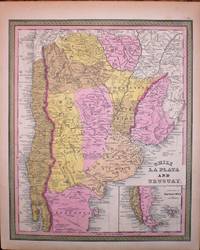
CHILI LA PLATA AND URUGUAY
de Mitchell, Samuel Augustus/Cowperthwait, Thomas
- Usado
- Estado
- Usado - Some minor chips to margins else very good
- Cantidad disponible
- 1
- Librería
-
Port Hope, Ontario, Canada
- Precio
-
EUR 116.74EUR 13.07 enviando a USA
Mostrar detalles
Descripción:
A detailed map of Chile, Uruguay and Argentina. Inset map of the tip of Patagonia.
Precio
EUR 116.74
EUR 13.07
enviando a USA
MAP OF SOUTH AMERICA. SHOWING ITS POLITICAL DIVISIONS. 1860
de Mitchell, Samuel Augustus
- Usado
- Estado
- Usado
- Cantidad disponible
- 1
- Librería
-
Port Hope, Ontario, Canada
- Precio
-
EUR 79.38EUR 13.07 enviando a USA
Mostrar detalles
Descripción:
Philadelphia: : S. Augustus Mitchell, , 1863. 13-1/2" x 11-1/2" - 34.2 x 29.2 cm. Lithograph with original hand colouring. Minor chips and browning to margins, else very good. A detailed and decorative map of all of South America with scrolling foliate border. Shows towns, cities, ports, and railroad lines. An inset map of the Proposed "Atrato-Inter-Oceanic" Canal Routes for Connecting the Atlantic and Pacific Oceans.
Precio
EUR 79.38
EUR 13.07
enviando a USA

SOUTH AMERICA ECUADOR, GRANADA, VENEZUELA AND PARTS OF BRAZIL AND GUYANA SHEET I
de [S.D.U.K.] Walker, J & C.
- Usado
- Estado
- Usado - Slightly toned but overall very good
- Cantidad disponible
- 1
- Librería
-
Port Hope, Ontario, Canada
- Precio
-
EUR 51.36EUR 13.07 enviando a USA
Mostrar detalles
Descripción:
A detailed map of Ecuador, Colombia, Venezuela, Guyana and Northern Brazil. Ports, towns, cities and ancient and topographical features are shown.
Precio
EUR 51.36
EUR 13.07
enviando a USA

South America Bolivia And Peru With A Part Of Brazil Sheet Vi
de [S.D.U.K.] Walker, J & C.
- Usado
- Estado
- Usado - Slightly toned, small tears lower right corner, but overall very good
- Cantidad disponible
- 1
- Librería
-
Port Hope, Ontario, Canada
- Precio
-
EUR 46.70EUR 13.07 enviando a USA
Mostrar detalles
Descripción:
A detailed map of of Peru, Bolivia and Brazil. Bolivia gained its independence from Spain in 1825. Ports, towns, cities and mountain ranges are shown.
Precio
EUR 46.70
EUR 13.07
enviando a USA
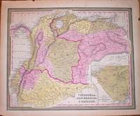
VENEZUELA, NEW GRENADA & EQUADOR
de Mitchell, Samuel Augustus/Cowperthwait, Thomas
- Usado
- Estado
- Usado - Minor chips to margins else very good
- Cantidad disponible
- 1
- Librería
-
Port Hope, Ontario, Canada
- Precio
-
EUR 93.39EUR 13.07 enviando a USA
Mostrar detalles
Descripción:
detailed map of Venezuela, Colombia and Equador. Inset map of proposed communication i.e. a railroad between the Atlantic and Pacific Ocean.
Precio
EUR 93.39
EUR 13.07
enviando a USA

¿No has encontrado lo que estabas buscando?
Prueba a añadir esta búsqueda a búsquedas guardadas Cada día se añaden millones de libros a Biblio. Cuando uno de ellos encaje con tu búsqueda, te enviaremos un correo para avisarte. Y lo mejor de todo, ¡es gratis!
Añadir a búsquedas guardadas

¿Eres un lector habitual o un coleccionista de libros?
Únete al Biblioclub y ahorra 10% en cada compra, ¡cada día! Hasta un máximo de 20$ en cada pedido

Responsabilidad social
¿Sabías que desde 2004 Biblio ha destinado sus beneficios a la construcción de 16 bibliotecas públicas en zonas rurales de Latinoamérica?
