MAPS from Monroe Bridge Books
Novedades

Dead Ends: An Irreverent Field Guide to the Graves of the Famous
de Cross, David / Bent, Robert
- Estado
- Usado - Very Good to Fine
- Published
- 1991
- Encuadernación
- Soft cover
- ISBN
- 9780452266797
- Cantidad disponible
- 1
- Librería
-
Houlton, Maine, USA
- Precio
-
EUR 23.34
Mostrar detalles
Descripción:
Plume / Advertising Unlimited, Inc., 1991 With an Edward Gorey Cover. Folding Map in Fine Condition, with Covers in Very Good ++ Condition. Color folding map encased in illustrated glossy stiff paper covers, includes the resting places of Andy Warhol, Lucille Ball, Rin Tin Tin, Rocky Marciano, Edgar Cayce. Patsy Cline and more. Precio
EUR 23.34

Massachusetts Aeronautical Chart
- Estado
- Usado - VERY GOOD ++
- Published
- 1988
- Encuadernación
- MAP
- Cantidad disponible
- 1
- Librería
-
Houlton, Maine, USA
- Precio
-
EUR 11.21
Mostrar detalles
Descripción:
Boston, Massachusetts: Massachusetts Aeronautics Commission, 1988 Folding color MAP, no tears, measuring approx. 19 inches tall by 26 3/4" wide. Includes a Legend, with an Airport Directory on the back side. Precio
EUR 11.21

Map of Siberia from Travels in Siberia: Including Excursions Northwards, Down the Obi, to the Polar Circle, and Southwards, to the Chinese Frontier
de Erman, Adolph
- Estado
- Usado - Very Good
- Published
- 1848
- Encuadernación
- MAP
- Cantidad disponible
- 1
- Librería
-
Houlton, Maine, USA
- Precio
-
EUR 70.04
Mostrar detalles
Descripción:
London: Longman, Brown, Green & Longmans, 1848 A Map if Siberia illustrating Erman's Route in red, which goes into Volume I as the frontis-piece. Slightly age darkened, light edge wear, no tears. When open it measures approximately 11" tall by 16-1/2" wide. Precio
EUR 70.04

Más fotos
BROCHURE - Visitor's Guide to New Orleans, with Two Maps
- Estado
- Usado - Very Good
- Published
- 1950
- Encuadernación
- Ephemera
- Cantidad disponible
- 1
- Librería
-
Houlton, Maine, USA
- Precio
-
EUR 14.01
Mostrar detalles
Descripción:
1950 Circa 1950. A two-panel Brochure, depicting a street map for Downtown New Orleans, along with a Map for the Port of New Orleans. Printed in blue ink. Precio
EUR 14.01

Más fotos
Ordnance Survey. Scotland - Sheet 14 (With Layers). Scale 2 Miles to 1 Inch.
- Estado
- Usado - Very Good
- Published
- 1912
- Encuadernación
- MAP
- Cantidad disponible
- 1
- Librería
-
Houlton, Maine, USA
- Precio
-
EUR 32.68
Mostrar detalles
Descripción:
Southampton: Published at the Ordnance Survey Office by Colonel C. F. Close, Director General, 1912 Linen backed, color map for Elgin, Keith, and Huntly, which folds into card stock protective covers, no tears. Measures approximately 28" tall by 20 1/2" wide. When folded up measures 7 1/4" tall by 3 6/8" wide. Precio
EUR 32.68

Más fotos
State of Maine. Map of Androscoggin - Kennebec Sagadahoc - Lincoln Counties
de Atwood, Paul E. [Topographer]
- Estado
- Usado - VERY GOOD ++
- Published
- 1961
- Encuadernación
- MAP
- Cantidad disponible
- 1
- Librería
-
Houlton, Maine, USA
- Precio
-
EUR 102.72
Mostrar detalles
Descripción:
Bangor, Maine: Prentiss & Carlisle Co., Inc. / Timberland Service, 1961 Measuring 29 1/2 " tall by 24" wide, encased in it's original brown envelope with a brass tab. The folding map in Very Good ++ Condition [no tears], with the envelope in Good Condition, showing darkening and a small edge tear. Precio
EUR 102.72

Nova Scotia Canada's Ocean Playground
- Estado
- Usado - Very Good
- Published
- 1950
- Encuadernación
- Soft cover
- Cantidad disponible
- 1
- Librería
-
Houlton, Maine, USA
- Precio
-
EUR 20.54
Mostrar detalles
Descripción:
Halifax, Nova Scotia: Nova Scotia Travel Bureau, 1950 Oblong Format, circa 1950. Unpaginated, staple bound, with a double page color map in the center of the book, color photographs throughout. NO LABELS, INSCRIPTIONS, NOR MARKINGS. Precio
EUR 20.54

Tabulae Topographicae Omnium Provinciarum Regularium Ord. Min. S. F. Conventualium, in Quibus Quaecumque Loca Seu Conventus Ab Eiusdem Ordinis Prima Institutione Ad Haec Usque Tempora Demonstrantur
de Righini, Fr. Master Francis Anthony
- Estado
- Usado - Very Good
- Published
- 1954
- Encuadernación
- Soft cover
- Cantidad disponible
- 1
- Librería
-
Houlton, Maine, USA
- Precio
-
EUR 42.02
Mostrar detalles
Descripción:
Syracuse: Associated Printing Service, 1954 Oblong format. A 1954 copy of the Second Edition (circa 1773). A copy of the Tabulae Topographicae was procured by Fr. Dominic Reuter, Min. Gen., OFMConv., for the I. C. Province Archives in Syracuse. It was then photographed page by page on glass negatives which are also kept in Syracuse; and from… Saber más sobre este artículo Precio
EUR 42.02
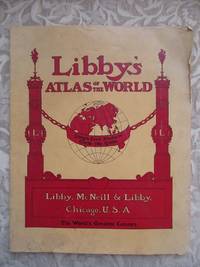
Libby's Atlas of the World
- Estado
- Usado - Good+
- Published
- 1902
- Encuadernación
- Soft cover
- Cantidad disponible
- 1
- Librería
-
Houlton, Maine, USA
- Precio
-
EUR 210.10
Mostrar detalles
Descripción:
Chicago, IL: Libby, McNeill & Libby [Packers & Preservers of Meats], 1902 Circa 1902. 40pp, printed on fine glossy paper, staple bound, with stiff paper covers. All maps present, and in color lithography. Includes photographs of Libby's meat packing plant in back. Covers lightly soiled, with edge wear. Back cover and last four leaves have… Saber más sobre este artículo Precio
EUR 210.10
Más fotos
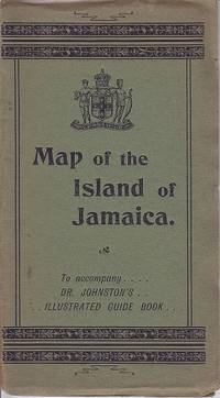
The Map of the Island of Jamaica To Accompany Dr. Johnston's Illustrated Guide Book
de Prepared Under the Direction of Thomas Harrison Gov't Surveyor By Colin Liddell
- Estado
- Usado - Map in Very Good ++ Condition
- Estado de la sobrecubierta
- Covers in Good Condition
- Published
- 1895
- Encuadernación
- Ephemera
- Cantidad disponible
- 1
- Librería
-
Houlton, Maine, USA
- Precio
-
EUR 233.45
Mostrar detalles
Descripción:
London: Stanford's Geographical Establishment, 1895 16 section, folding, color lithograph map, housed in it's original, stiff green paper covers. Opens to measure an oblong 13-1/4" X 27", with the upper left section mounted onto the paper covers. No tears to the map, occasional light foxing. Covers sunned, with edge wear. Precio
EUR 233.45

Asher Rare Books Catalogue 27. Rare and Important Books and Atlases Including Some Manuscripts
- Estado
- Usado - VERY GOOD ++
- Edición
- First Edition
- Published
- 1997
- Encuadernación
- Soft cover
- Cantidad disponible
- 1
- Librería
-
Houlton, Maine, USA
- Precio
-
EUR 24.28
Mostrar detalles
Descripción:
The Netherlands: A. Asher & Co. B. V., 1997 101pp, printed on fine glossy paper, bound in stiff paper covers, with binding and hinges tight, illustrated throughout. NO LABELS, INSCRIPTIONS, NOR MARKINGS. Precio
EUR 24.28
![The Cape Ann Trail. Compliments of Board of Trade, Rockport, Massachusetts [GUIDE & MAP]](https://d3525k1ryd2155.cloudfront.net/h/490/489/921489490.0.m.jpg)
The Cape Ann Trail. Compliments of Board of Trade, Rockport, Massachusetts [GUIDE & MAP]
- Estado
- Usado - Very Good
- Published
- 1930
- Encuadernación
- MAP
- Cantidad disponible
- 1
- Librería
-
Houlton, Maine, USA
- Precio
-
EUR 42.02
Mostrar detalles
Descripción:
Gloucester, Massachusetts: Chamber of Commerce, 1930 Folded, measures 10-1/4" tall x 4-3/8" wide. Opened, measures 26" high by 20-1/2" wide. Black and white drawn map, with a red numbered trail, which corresponds to the numbered places on the vignette border. A few small crease tears. Includes descriptive paragraphs on the various locations of interest, on the… Saber más sobre este artículo Precio
EUR 42.02
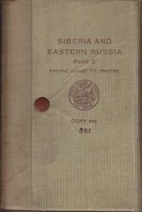
Siberia and Eastern Russia. Part II - Pacific Coast to Irkutsk, Route Notes and Information. SCARCE.
de Military Monograph Subsection M. I. 2 / Military Intelligence Division / General Staff
- Estado
- Usado - Very Good
- Edición
- Limited Edition
- Published
- 1918
- Encuadernación
- Hardcover
- Cantidad disponible
- 1
- Librería
-
Houlton, Maine, USA
- Precio
-
EUR 770.38
Mostrar detalles
Descripción:
Washington: Government Printing Office, 1918 LIMITED EDITION, #361 of 2000 Copies, issued to Captain L. P. Johns, 27th Infantry. Listed as "CONFIDENTIAL / FOR OFFICIAL USE ONLY". 180pp, xxxvii, bound in tan cloth, with folding snap closure. Includes a mounted Russian Alphabet, long folding photographic frontis-piece, 1 folding map, 15 full page maps and routes, 88 photographic… Saber más sobre este artículo Precio
EUR 770.38
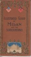
Practical Guide of Milan and Its Environs with 17 Vignettes and Plan
- Estado
- Usado - Good to Very Good
- Edición
- First Edition
- Published
- 1901
- Encuadernación
- Soft cover
- Cantidad disponible
- 1
- Librería
-
Houlton, Maine, USA
- Precio
-
EUR 44.82
Mostrar detalles
Descripción:
Bergamo: Istituto Italiano D'Arti Grafiche, 1901 48pp, printed on fine glossy paper, dated Septemb. 1901, with photographs throughout. Includes the FOLDING STREET MAP, which when opened measures 18-1/4" tall by 15-1/8" wide, [no tears]. Includes an original b/w photograph of the Milan Cathedral at the Piazza Del Duomo, laid-in. In a protective mylar sleeve. Precio
EUR 44.82
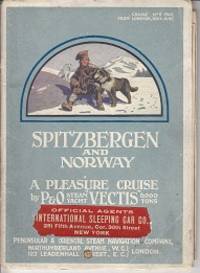
Spitzbergen and Norway. A Pleasure Cruise By P & O Steam Yacht "Vectis" 6,000 Tons. Cruise No. 5, 1910, From London, 30th June
- Estado
- Usado - Good
- Edición
- First Edition
- Published
- 1910
- Encuadernación
- Soft cover
- Cantidad disponible
- 1
- Librería
-
Houlton, Maine, USA
- Precio
-
EUR 210.10
Mostrar detalles
Descripción:
London: Peninsular & Oriental Steam Navigation Company, 1910 33pp, printed on fine glossy paper, single cord bound, with colour illustrated, stiff paper covers, with binding tight. Includes a folding map, with a Cabin Plan on the reverse side. Covers show wear/rubbing, with a label "Official Agents / International Sleeping Car Co. / 281 Fifth Avenue, Cor. 30th Street… Saber más sobre este artículo Precio
EUR 210.10
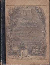
Primary American History, For Primary Schools - Illustrated Edition
de Willson, Marcius
- Estado
- Usado - Very Good
- Published
- 1867
- Encuadernación
- Hardcover
- Cantidad disponible
- 1
- Librería
-
Houlton, Maine, USA
- Precio
-
EUR 72.84
Mostrar detalles
Descripción:
New York: Ivison, Phinney, Blakeman & Co,, 1867 Complete with 164 pages, 4 colour maps in back, black and white maps, text illustrations and plates throughout. Bound in half leather, and illustrated paper over boards, binding and hinges tight. Covers age darkened, lacking all but one of the free endpapers. Precio
EUR 72.84

Guide to Boston and Cambridge with Telephone Information - Issued for The Armed Forces
- Estado
- Usado - Very Good
- Published
- 1942
- Encuadernación
- Soft cover
- Cantidad disponible
- 1
- Librería
-
Houlton, Maine, USA
- Precio
-
EUR 26.15
Mostrar detalles
Descripción:
Boston: New England Telephone and Telegraph Company, 1942 (Circa 1942) Unpaginated, 6 leaves on glossy paper, with photographs, stapled booklet bound in original stiff paper covers, with binding tight. DOUBLE-SIDED FOLDING MAP IN BACK, Courtesy of Harvard University. One side showing the streets of Old Cambridge, and the other Down-Town Boston [no tears]. Some creases to… Saber más sobre este artículo Precio
EUR 26.15
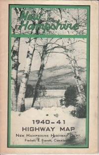
New Hampshire 1940-41 Highway Map
- Estado
- Usado - Very Good
- Published
- 1942
- Encuadernación
- Ephemera
- Cantidad disponible
- 1
- Librería
-
Houlton, Maine, USA
- Precio
-
EUR 26.15
Mostrar detalles
Descripción:
New Hampshire Highway Department, 1942 Includes photographs of *The Old Man of the Mountains *Robert's Cove at Lake Winnipesaukee *Aerial Tramway at Cannon Mountain *Pinkham Notch *Dartmouth College *Dixville Notch along with others. Color folding map opens up to 28-1/2 by 18-1/4 inches. Precio
EUR 26.15
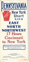
Pennsylvania New York Short Line - Through Cars and New Fast Time - East North Northwest. Time Tables Corrected to March 4, 1906 MAP & TIME TABLES
de Hagerty, C. H. [District Passenger Agent] and Others
- Estado
- Usado - Good
- Published
- 1906
- Encuadernación
- MAP
- Cantidad disponible
- 1
- Librería
-
Houlton, Maine, USA
- Precio
-
EUR 51.36
Mostrar detalles
Descripción:
Chicago: Poole Bros., 1906 9-28-05-E Folding Railroad Time Table, that open up to a color map of the United States, showing their connections. Opens up to 15-1/2" tall by 28" wide. Edge wear to folded time tables, which results in a crease tear to the map. In a protective mylar sleeve. RAILROAD. Precio
EUR 51.36
