1860 Colton's Map: New York, New Jersey, Pennsylvania, & Delaware. / Vermont, Massachusetts, Rhode Island, & Connecticut -
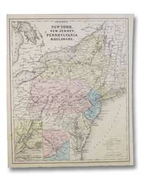
1860 Colton's Map: New York, New Jersey, Pennsylvania, & Delaware. / Vermont, Massachusetts, Rhode Island, & Connecticut
- Usado
- very good
New York: J.H. Colton and Company, 1860. Single Sheet. Very Good. Unfolded. Minimal loss from bottom margin, a few faint spots. 1860 Single Sheet. Two maps on opposite sides of a single sheet. 10 3/8 x 12 5/8. The Colton family was very successful in the business of map publishing, beginning with J.H. Colton and continuing with his sons George W. and Charles B. Colton.
-
Librería
Yesterday's Muse Books
 (US)
(US)
- Formato/Encuadernación Single Sheet
- Estado del libro Usado - Very Good
- Cantidad disponible 1
- Editorial New York: J.H. Colton and Company
- Fecha de publicación 1860
- Palabras clave MAPS CARTOGRAPHY ATLAS GEORGE W. COLTON NORTH AMERICAN AMERICA AMERICANA UNITED STATES U.S. GEOGRAPHY POLITICAL PHYSICAL GEOGRAPHICAL CARTOGRAPHIC CARTOGRAPHER