Descripción:
Amsterdam: Schenk and Valk, 1708. Very good, minimal foxing, early color copperplate from this 1708 (original version published in 1660 by Jansson) Schenk/Valk issue of (Andreas Cellarius') "Harmonia Macrocosmica Seu Atlas Universalis Et Novus." The striking image measures 41 x 51 cm on a sheet 50 x 59 cm. Numerous cherubim surrond the eastern hemispheric view, which is also divided into frigid, termperate, tropical and torrid zones. There are separate armillary and habitat zonal spheres in the lower corners. Ref: Koeman, Atlantes Neerlandici, Cel.3. There are bilateral, faint water-stains in the pink circular band surrounding the map image..
Americae Nova Tabula [Original Antique Engraved Map] de Blaeuw, Guiljelmo [Abraham Blaeu] - 1634
de Blaeuw, Guiljelmo [Abraham Blaeu]
![Americae Nova Tabula [Original Antique Engraved Map] de Blaeuw, Guiljelmo [Abraham Blaeu] - 1634](https://d3525k1ryd2155.cloudfront.net/h/131/502/637502131.0.m.jpg)
Americae Nova Tabula [Original Antique Engraved Map]
de Blaeuw, Guiljelmo [Abraham Blaeu]
- Usado
- near fine
Abraham Baeu [Blaeuw], 1634. Original Antique Map . No Binding. Near Fine. 20" x 17. Laid Paper. Image Size: 21.67" X 16.2", 55 Cm X 42.1 Cm. Cartouche With "Americae Nova Tabula. Auct: Guiljelmo Blaeuw. 1634. "Text "Cum Privilegio Docem Annorum" At Lower Left. An Excellent Example With Strong Impression And Very Attractive Muted Color. Professionally Cleaned And De-Acidified With Archival Materials By A Museum-Experienced Conservator.
-
Librería
Arroyo Seco Books
 (US)
(US)
- Formato/Encuadernación No Binding
- Estado del libro Usado - Near Fine
- Cantidad disponible 1
- Edición Original Antique Map
- Editorial Abraham Baeu [Blaeuw]
- Fecha de publicación 1634
- Tamaño 20" x 17
- Palabras clave General
- X weight 0 lb
- Size 20" x 17

(Old World hemispheric map with climatic zones): Hemisphaerium Orbis Antiqui, Cumzonis, Circulis, Et Situ Populorum Diverso
de Valk, Gerard and Schenk, Petrus [Cellarius, Andreas]
- Usado
- Estado
- Usado
- Encuadernación
- Unknown
- Cantidad disponible
- 1
- Librería
-
Crozet, Virginia, United States
- Precio
-
EUR 2,516.10
Mostrar detalles
Precio
EUR 2,516.10

Amerique Septrionale [ Original Map From The Atlas Universal Illustre, By Levasseur, V. / Laguillermie]
de Levasseur, V. / Laguillermie
- Usado
- Estado
- Usado - Very Good +
- Edición
- Original Antique Map
- Encuadernación
- Unknown
- Cantidad disponible
- 1
- Librería
-
Pasadena, California, United States
- Precio
-
EUR 126.98
Mostrar detalles
Descripción:
Paris Circa 1840: A. Combette, 1840. Original Antique Map . Single Sheet. Very Good +. 21" x 14 1/4. Large Color Views By Raimond Bonheur. Original Decorative Map 21" X 14 1/4" Of North America Showing The United States As Claiming Much Of British Colombia, With The West Coast Of The Usa Continuing Well Into Present-Day Canada; Texas As A Republic; Guatemala Encompassing All Of Central America South Of Chiapas And Belize And North Of Panama. Large Panels At Sides With Detailed, Attractive And Well Colored Views Of People, Wildlife, Vegetation, High Mountains, Etc.Colors Very Bright And Well-Placed.
Precio
EUR 126.98
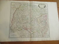
Cercle De Souabe [Original Antique Map from the Atlas Universal of 1757, with Lake Constance, Stuttgart, Augsburg, Etc.]
de Vaugondy, Robert
- Usado
- near fine
- Estado
- Usado - Near Fine
- Edición
- Original Antique Map
- Encuadernación
- Unknown
- Cantidad disponible
- 1
- Librería
-
Pasadena, California, United States
- Precio
-
EUR 338.62
Mostrar detalles
Descripción:
Paris: Robert Vaugondy, 1751. Original Antique Map . Single Sheet. Near Fine. 22" x 32. Original very large antique map, extracted from an atlas. Very detailed, with hundreds of towns and villages, probably all in existence at the time, and showing jurisdictional boundaries as well.
Precio
EUR 338.62
![Americae Sive Novi Orbis, Nova Descriptio [Reprinted Engraved Antique Map]](https://d3525k1ryd2155.cloudfront.net/h/585/523/637523585.0.m.jpg)
Americae Sive Novi Orbis, Nova Descriptio [Reprinted Engraved Antique Map]
de Ortelius, Abraham
- Usado
- near fine
- Estado
- Usado - Near Fine
- Estado de la sobrecubierta
- No Jacket
- Edición
- 5th or later Edition
- Encuadernación
- Unknown
- Cantidad disponible
- 1
- Librería
-
Pasadena, California, United States
- Precio
-
EUR 253.96
Mostrar detalles
Descripción:
(: Abraham Ortelius (Original 1587 But This A Reprint), 1587. 5th or later Edition . No Binding. Near Fine/No Jacket. 19" x 17. Image Size: 18 7/8" X 13 3/4". Text "Cum Privilegio Decennali Ab. Ortelius Delineab. Et Excudeb. 1587" At Lower Right. However, This Must Be A Late Eighteenth Century To Twentieth Century Reprint, Printed On Wove Paper, Sheet Never Placed In An Atlas. Strong Impression And Color, Minor Loss Of A Millimeter Depth In A Tiny Area Of Lower Left Margin, Otherwise Undamaged. Margins Irregular, Up To 1" Deep. Professionally Cleaned And De-Acidified With Archival Materials By A Museum-Experienced Conservator.
Precio
EUR 253.96

Más fotos
抗美援朝時事學習地圖. [Kang Mei yuan Chao shi shi xue xi di tu]. [Current Affairs Study Map - Resisting US Aggression and Aiding Korea].
de [YA XIN CARTOGRAPHIC STUDY SOCIETY].[亞新地學社].
- Usado
- First
- Estado
- Usado
- Edición
- 1st Edition.
- Encuadernación
- Unknown
- Cantidad disponible
- 1
- Librería
-
Canberra, Australian Capital Territory, Australia
- Precio
-
EUR 1,708.85
Mostrar detalles
Descripción:
武昌.[Wuchang].: 亞新地學社.[Ya xin di xue she].. 1st Edition.. August1951.. Large detailed colour Chinese map of Korean War, folded, scale 1:15,000,000, three inset maps on corners, illustrated legend showing agricultural and mining resources lower margin, in original envelope. Some light wear along edges, small holes and wear at folds mended with archival tape, envelope torn with loss mended with archival tape. Inset map 兩個陣營力量對比 "Strength Comparison Between The Two Camps" upper left corner, scale 1: 170,000,000. The Peaceful Camp in red covering the majority of Asia and Europe, a list of 6 countries (Germany, Czech, Hungary, Romania, Bulgaria, Albania) are numbered and are also part of the Peaceful Camp. The Invader Camp in grey covering North America and small parts of Europe, a list of 3 nations (Netherlands, Belgium, Luxembourg) are numbered and are also part of the Invader Camp. Block of text in…
Leer más Precio
EUR 1,708.85
(Old World hemispheric map with climatic zones): Hemisphaerium Orbis Antiqui, Cumzonis, Circulis, Et Situ Populorum Diverso
de Valk, Gerard and Schenk, Petrus [Cellarius, Andreas]
- Usado
- Estado
- Usado
- Encuadernación
- Unknown
- Cantidad disponible
- 1
- Librería
-
Crozet, Virginia, United States
- Precio
-
EUR 2,516.10
Mostrar detalles
Descripción:
Amsterdam: Schenk and Valk, 1708. Very good, minimal foxing, early color copperplate from this 1708 (original version published in 1660 by Jansson) Schenk/Valk issue of (Andreas Cellarius') "Harmonia Macrocosmica Seu Atlas Universalis Et Novus." The striking image measures 41 x 51 cm on a sheet 50 x 59 cm. Numerous cherubim surrond the eastern hemispheric view, which is also divided into frigid, termperate, tropical and torrid zones. There are separate armillary and habitat zonal spheres in the lower corners. Ref: Koeman, Atlantes Neerlandici, Cel.3. There are bilateral, faint water-stains in the pink circular band surrounding the map image..
Precio
EUR 2,516.10
Amerique Septrionale [ Original Map From The Atlas Universal Illustre, By Levasseur, V. / Laguillermie]
de Levasseur, V. / Laguillermie
- Usado
- Estado
- Usado - Very Good +
- Edición
- Original Antique Map
- Encuadernación
- Unknown
- Cantidad disponible
- 1
- Librería
-
Pasadena, California, United States
- Precio
-
EUR 126.98
Mostrar detalles
Descripción:
Paris Circa 1840: A. Combette, 1840. Original Antique Map . Single Sheet. Very Good +. 21" x 14 1/4. Large Color Views By Raimond Bonheur. Original Decorative Map 21" X 14 1/4" Of North America Showing The United States As Claiming Much Of British Colombia, With The West Coast Of The Usa Continuing Well Into Present-Day Canada; Texas As A Republic; Guatemala Encompassing All Of Central America South Of Chiapas And Belize And North Of Panama. Large Panels At Sides With Detailed, Attractive And Well Colored Views Of People, Wildlife, Vegetation, High Mountains, Etc.Colors Very Bright And Well-Placed.
Precio
EUR 126.98
Cercle De Souabe [Original Antique Map from the Atlas Universal of 1757, with Lake Constance, Stuttgart, Augsburg, Etc.]
de Vaugondy, Robert
- Usado
- near fine
- Estado
- Usado - Near Fine
- Edición
- Original Antique Map
- Encuadernación
- Unknown
- Cantidad disponible
- 1
- Librería
-
Pasadena, California, United States
- Precio
-
EUR 338.62
Mostrar detalles
Descripción:
Paris: Robert Vaugondy, 1751. Original Antique Map . Single Sheet. Near Fine. 22" x 32. Original very large antique map, extracted from an atlas. Very detailed, with hundreds of towns and villages, probably all in existence at the time, and showing jurisdictional boundaries as well.
Precio
EUR 338.62
Americae Sive Novi Orbis, Nova Descriptio [Reprinted Engraved Antique Map]
de Ortelius, Abraham
- Usado
- near fine
- Estado
- Usado - Near Fine
- Estado de la sobrecubierta
- No Jacket
- Edición
- 5th or later Edition
- Encuadernación
- Unknown
- Cantidad disponible
- 1
- Librería
-
Pasadena, California, United States
- Precio
-
EUR 253.96
Mostrar detalles
Descripción:
(: Abraham Ortelius (Original 1587 But This A Reprint), 1587. 5th or later Edition . No Binding. Near Fine/No Jacket. 19" x 17. Image Size: 18 7/8" X 13 3/4". Text "Cum Privilegio Decennali Ab. Ortelius Delineab. Et Excudeb. 1587" At Lower Right. However, This Must Be A Late Eighteenth Century To Twentieth Century Reprint, Printed On Wove Paper, Sheet Never Placed In An Atlas. Strong Impression And Color, Minor Loss Of A Millimeter Depth In A Tiny Area Of Lower Left Margin, Otherwise Undamaged. Margins Irregular, Up To 1" Deep. Professionally Cleaned And De-Acidified With Archival Materials By A Museum-Experienced Conservator.
Precio
EUR 253.96
Más fotos
抗美援朝時事學習地圖. [Kang Mei yuan Chao shi shi xue xi di tu]. [Current Affairs Study Map - Resisting US Aggression and Aiding Korea].
de [YA XIN CARTOGRAPHIC STUDY SOCIETY].[亞新地學社].
- Usado
- First
- Estado
- Usado
- Edición
- 1st Edition.
- Encuadernación
- Unknown
- Cantidad disponible
- 1
- Librería
-
Canberra, Australian Capital Territory, Australia
- Precio
-
EUR 1,708.85
Mostrar detalles
Descripción:
武昌.[Wuchang].: 亞新地學社.[Ya xin di xue she].. 1st Edition.. August1951.. Large detailed colour Chinese map of Korean War, folded, scale 1:15,000,000, three inset maps on corners, illustrated legend showing agricultural and mining resources lower margin, in original envelope. Some light wear along edges, small holes and wear at folds mended with archival tape, envelope torn with loss mended with archival tape. Inset map 兩個陣營力量對比 "Strength Comparison Between The Two Camps" upper left corner, scale 1: 170,000,000. The Peaceful Camp in red covering the majority of Asia and Europe, a list of 6 countries (Germany, Czech, Hungary, Romania, Bulgaria, Albania) are numbered and are also part of the Peaceful Camp. The Invader Camp in grey covering North America and small parts of Europe, a list of 3 nations (Netherlands, Belgium, Luxembourg) are numbered and are also part of the Invader Camp. Block of text in…
Leer más Precio
EUR 1,708.85

Más fotos
The Sky and the Forest
de Forester, C.S
- Usado
- very good
- Tapa dura
- First
- Estado
- Usado - Very Good
- Estado de la sobrecubierta
- Very Good
- Edición
- First Edition
- Encuadernación
- Hardcover
- Cantidad disponible
- 1
- Librería
-
Salem, Oregon, United States
- Precio
-
EUR 32.82EUR 16.41¡Ahorra EUR 17.44!
Mostrar detalles
Descripción:
C.S. Forester: The Sky and the Forest. Little, Brown and Company, Boston. Stated First Edition First Printing Thus August, 1948. Cover price $2.75. Used. VG BOOK/VG UNCLIPPED DUST JACKET. A story of a central Africa. By C.S. Forester, author of the Admiral Hornblower series.
Precio
EUR 32.82EUR 16.41
¡Ahorra EUR 17.44
!
![Alaska and Klondike Region; [With inset of Klondike Region on the Upper Yukon detail] [From an...](https://d3525k1ryd2155.cloudfront.net/h/062/537/1339537062.0.m.jpg)
Alaska and Klondike Region; [With inset of Klondike Region on the Upper Yukon detail] [From an atlas, "Gazetteer of Alaska and Yukon Region " pp. 105 and 106]
de Miller, J. Martin
- Usado
- very good
- Estado
- Usado - Very Good
- Edición
- Unknown
- Cantidad disponible
- 1
- Librería
-
Sebastopol, California, United States
- Precio
-
EUR 36.68
Mostrar detalles
Descripción:
Chicago: J. Martin Miller, 1899. Unknown. Map. Very Good. [Map copyright 1899, printing date of Atlas later] [19.875x15.125in]; Colored map of Alaska with steamer routes from Portland and Seattle, insets of the Klondike Region on the Upper Yukon and Western portion of Aleutian Islands; On verso index of places and names with two large black and white images; Age toning to all edges, water stain marks on bottom, slight printing offset of colors, small chips and closed tears to lower edge;.
Precio
EUR 36.68

Last Tales
de Dinesen, Isak
- Usado
- very good
- Tapa dura
- First
- Estado
- Usado - Very Good
- Estado de la sobrecubierta
- Good+
- Edición
- First Edition
- Encuadernación
- Hardcover
- Cantidad disponible
- 1
- Librería
-
Salem, Oregon, United States
- Precio
-
EUR 112.87EUR 56.44¡Ahorra EUR 60.00!
Mostrar detalles
Descripción:
Dinesen, Isak: Last Tales, A Collection of Twelve New Tales of Compelling Beauty 1957, Random House. First Edition. Stated First Printing Thus. Used. Very Good/Good+ original red dust jacket, price-clipped. Jacket states 11/57 on front flap. 5 3/4 X
Precio
EUR 112.87EUR 56.44
¡Ahorra EUR 60.00
!

Zemepis Sveta - Monsunova Asie
de De La Blache, P. Vidal; Gallois, L
- Usado
- Tapa dura
- Estado
- Usado - Very Good Condition
- Estado de la sobrecubierta
- No Dust Jacket
- Encuadernación
- Hardcover
- Cantidad disponible
- 1
- Librería
-
Oak Point, Texas, United States
- Precio
-
EUR 56.44
Mostrar detalles
Descripción:
Aventinum, Prague, Czechoslovakia, 1931. Hardcover. Very Good Condition/No Dust Jacket. Text entirely in Czech. Geography book on Asia with numerous photographs and maps. 1930 edition also available. Size: 4mo - over 9 3/4" - 12" tall. 400 pp. Pages are yellowed, but are tight and clean. Moderate shelfwear along the spine. Corners are lightly bumped. Quantity Available: 1. Shipped Weight: 3-5 pounds. Category: Travel & Places; Non-English Language::Czech; Pictures of this item not already displayed here available upon request. Inventory No: 001228. . Additional shipping charges may apply.
Precio
EUR 56.44

Zemepis Sveta - Monsunova Asie
de De La Blache, P. Vidal; Gallois, L
- Usado
- Tapa dura
- Estado
- Usado - Very Good Condition
- Estado de la sobrecubierta
- No Dust Jacket
- Encuadernación
- Hardcover
- Cantidad disponible
- 1
- Librería
-
Oak Point, Texas, United States
- Precio
-
EUR 56.44
Mostrar detalles
Descripción:
Aventinum, Prague, Czechoslovakia, 1930. Hardcover. Very Good Condition/No Dust Jacket. Text entirely in Czech. Geography book on Asia with numerous photographs and maps. 1931 edition also available. Size: 4mo - over 9 3/4" - 12" tall. 400 pp. Pages are yellowed, but are tight and clean. Moderate shelfwear along the spine. Corners are lightly bumped. Quantity Available: 1. Shipped Weight: 3-5 pounds. Category: Travel & Places; Non-English Language::Czech; Pictures of this item not already displayed here available upon request. Inventory No: 001227. . Additional shipping charges may apply.
Precio
EUR 56.44

The Adventure of Wrangel Island
de Vilhjalmur Stefansson
- Usado
- good
- Tapa dura
- First
- Estado
- Usado - Good
- Estado de la sobrecubierta
- No DJ Included
- Edición
- First Edition
- Encuadernación
- Hardcover
- Cantidad disponible
- 1
- Librería
-
Salem, Oregon, United States
- Precio
-
EUR 117.47EUR 58.74¡Ahorra EUR 62.44!
Mostrar detalles
Descripción:
The Adventure of Wrangel Island, Alaska (1925 Macmillan 1st Edition) HISTORY OF ALASKA. EXLIB. Good Condition/ No DJ included. Fold-out map affixed to binding at the back of the book has never been opened. The story of the (unsuccessful) attempted colonization of Wrangel Island Alaska. 413 pages plus appendix, Index. Titling is still bright. A clean, solid copy. Scarce.
Precio
EUR 117.47EUR 58.74
¡Ahorra EUR 62.44
!

Seven Pillars Of Wisdom, A Triumph
de Lawrence, T.E
- Usado
- good
- Tapa dura
- First
- Estado
- Usado - Good
- Estado de la sobrecubierta
- No DJ Included
- Edición
- First American Edition
- Encuadernación
- Hardcover
- Cantidad disponible
- 1
- Librería
-
Salem, Oregon, United States
- Precio
-
EUR 117.53EUR 58.77¡Ahorra EUR 62.47!
Mostrar detalles
Descripción:
T.E. Lawrence. SEVEN PILLARS OF WISDOM, A TRIUMPH. AUTOBIOGRAPHY. Privately Printed, 1926. First Published for general circulation 1935. First American Edition. States MCMXXXVI on the title page. Doubleday, Doran & Company, Inc. Garden City, NY. GOOD CONDITION/ NO DUST JACKET IS INCLUDED. 672 pages, indexed. Beige buckram boards. Spine has darkened a bit. 6 7/8 X 9 ½.
Precio
EUR 117.53EUR 58.77
¡Ahorra EUR 62.47
!

North America from the Best Authorities, Russell, ca.1800
de Russell
- Usado
- Estado
- Usado
- Cantidad disponible
- 1
- Librería
-
Plymouth, Devon, United Kingdom
- Precio
-
EUR 23.60
Mostrar detalles
Descripción:
Russell, J. : A General Map of North America from the Best Authorities. Nd but ca.1800. From "A New Geographical, Historical and Commercial Grammar and Present State of Several Kingdoms of the World." Copper engraving. Size approx 200 x 230mm. Two neat folds. Some age colouring to edges, otherwise very clean and bright.
Precio
EUR 23.60

Asia from the Best Authorities, Russell, ca.1800
de Russell
- Usado
- Estado
- Usado
- Cantidad disponible
- 1
- Librería
-
Plymouth, Devon, United Kingdom
- Precio
-
EUR 23.60
Mostrar detalles
Descripción:
Russell, J. : Asia from the Best Authorities. Nd but ca.1800. From "A New Geographical, Historical and Commercial Grammar and Present State of Several Kingdoms of the World". Copper engraving. Size approx 200 x 230mm. Two neat folds. Some age colouring to edges, otherwise clean and bright. Includes Arabia, India, Borneo, Japan, China and eastern Russia.
Precio
EUR 23.60
![MAP OF UTAH [Territory]](https://d3525k1ryd2155.cloudfront.net/h/836/461/1485461836.0.m.jpg)
Más fotos
MAP OF UTAH [Territory]
- Usado
- Estado
- Usado - Very Good-
- Edición
- Original
- Cantidad disponible
- 1
- Librería
-
Williamsburg, Virginia, United States
- Precio
-
EUR 61.14
Mostrar detalles
Descripción:
New York, Richmond, Chicago, & Toledo: H. H. Hardesty, 1885. Original color lithographed map printed by Rand, McNally & Company, Engravers and published in HARDESTY'S HISTORICAL AND GEOGRAPHICAL ENCYCLOPEDIA: SPECIAL VIRGINIA EDITION. 19 3/8 inches by 13 1/4 inches on a 21" X 14 1/2" sheet. The map depicts the Territory of Utah in its final form--large areas had been removed and ceded to Nevada, Colorado, Wyoming, and Nebraska since Utah became a U. S. Territory in 1850. The issue of polygamy prevented statehood until it was finally granted in 1896. This map features railroads and topography and uses color to set off counties from each other. Unlike most atlas maps of the period, this map identifies most small towns. The map is guaranteed to be moe than 135 years old. The map is in about very good condition: generally clean and bright, with slight toning of paper and one faint water stain near the center-left edge of the map.. Original. Single Sheet. Very Good-. Elephant…
Leer más Precio
EUR 61.14