Descripción:
Augsburg: Seutter, 1740. VG+, copperplate engraving with original hand coloring (color similar to Homann, with whom Seutter apprenticed before going out on his own in about 1707). There is minimal right marginal soling, but the image and color are exceptionally bright. Decorative cartouche, as usual, probably an allegorical representation of imperial Russia. The map measures 19.25x22.5 inches. .
Atlas of the Town of Hyde Park Norfolk County, Mass. From Official Plans and Actual Surveys de Anon - 1899
de Anon

Atlas of the Town of Hyde Park Norfolk County, Mass. From Official Plans and Actual Surveys
de Anon
- Usado
- very good
- Tapa dura
Boston: Geo. W. Stadly, 1899. Hardcover. Very Good. Large folio, 21" x 16 1/2". 12 maps of Hyde Park, all double page and colored. A few small marks and occasional thumb marks in the margins, but generally bright and quite attractive with no tears. Incorporated into the City of Boston in 1912 to become the southernmost neighborhood in the city, Hyde Park at this point was a separate city and the northernmost town in Norfolk County.
Brown cloth spine and corners over embossed cloth boards - heavily worn at corners, well through to the boards - binding shows relatively modest wear and rubbing otherwise. Binding tight, boards a little bowed.
At the time an industrial town situated at the confluence of the Neponset and the Mother Brook and connected to Boston by Hyde Park Avenue. It was home to the 54th Massachusetts Volunteer Infantry (the "Glory" division). Just one copy in OCLC at the Boston Public Library. Size: Elephant folio. Quantity Available: 1. Shipped Weight: 2-3 kilos. Category: Countries & Travel; Inventory No: 038090.
-
Librería
Pazzo Books
 (US)
(US)
- Formato/Encuadernación Tapa dura
- Estado del libro Usado - Very Good
- Cantidad disponible 1
- Encuadernación Tapa dura
- Editorial Geo. W. Stadly
- Lugar de publicación Boston
- Fecha de publicación 1899
- Palabras clave Countries & Travel; NOISBN

(Map of Caspian Sea & Environs): Nova et Accuratissima Maris Caspii...petri Alexii Filii. Magni Russorum Emper
de Seutter, GM
- Usado
- Estado
- Usado
- Encuadernación
- Unknown
- Cantidad disponible
- 1
- Librería
-
Crozet, Virginia, United States
- Precio
-
EUR 516.72
Mostrar detalles
Precio
EUR 516.72

CENT VUES SUISSES remarquables par leur Situation, ou par des Faits Historiques. Dessinn�es et grav�es par Hess, Hegui [sic], K�nig, Lory, Meyer, Wetzel etc.
de Orell, F�ssli (Publishers)
- Usado
- very good
- Tapa dura
- Estado
- Usado - Very Good
- Encuadernación
- Hardcover
- Cantidad disponible
- 1
- Librería
-
Blockley, Gloucestershire, United Kingdom
- Precio
-
EUR 896.72
Mostrar detalles
Descripción:
Zurich: Orell, F�ssli et Comp., 1825 approx). Hardcover. Very Good. Copperplate engravings (100) of Swiss views and domestic scenes by Hess, Hegui, K�nig, Lory, Meyer, Wetzel and others.. Oblong octavo green morocco elaborately gilt on 4 raised bands (lacks lowest spine compartment, tips & hinges worn but sound) All Edges Gilt. Titlepage +[3]pp publisher's list +[4]pp contents + 100 plate leaves printed one side only. Clean and crisp - lovely views with a few genre scenes - wedding, peasants defending land against invaders in 1798, making cheese etc. Minor foxing almost entirely to the margins or blank back of plates, small wormhole at foot of 3 leaves. *A charming work containing views by various artists here collected together for the first time (Lonchamp 3199).
Precio
EUR 896.72

Más fotos
FL
de Wolff, Stephanie and Dorothy Simpson Krause.
- Usado
- Firmado
- Estado
- Usado
- Edición
- Edition of 10 variants
- Encuadernación
- Unknown
- Cantidad disponible
- 1
- Librería
-
Hoover, Alabama, United States
- Precio
-
EUR 751.60
Mostrar detalles
Descripción:
[Boca Raton, Florida]:: Jaffe Center for the Book Arts,, 2015.. Edition of 10 variants. 7.25 x 3.5"; 12 pages. Flutter book. Letterpress printed. Colophon with a map of Florida laser-printed. Cover and pages incorporate letterpress printing on a Vandercook 4 proof press using wood type, metal and collagraph plates. Blind printing of an area map. Printed on Arches 88 paper. Plant inclusion endpapers. Laid in handmade paper wrapper with slit-and-slot closure. Signed and numbered by the artists. Statement: "During Stephanie Wolff's residency at the Jaffe Center for Book Arts, she and Dorothy Krause, the first resident artist, collaborated on this brief ode to Florida. A variety of Pigment prints of vintage documents, maps, photographs and botanicals were transferred onto the pages of this edition of 10 variable copies.
Precio
EUR 751.60
![Penbrokshyre [Pembrokeshire],](https://d3525k1ryd2155.cloudfront.net/h/271/137/1078137271.0.m.jpg)
Más fotos
Penbrokshyre [Pembrokeshire],
de John Speed
- Usado
- Estado
- Usado
- Cantidad disponible
- 1
- Librería
-
Plymouth, Devon, United Kingdom
- Precio
-
EUR 588.40
Mostrar detalles
Descripción:
Speed, John : Penbrokshyre described and the sittuations both of Penbroke and St Davids Shewed in due form as they were taken by John Speed. Sold by Bassett and Chiswell. Size approx 510mm x 380mm ( 20 x 15 inches). Early hand coloured double page copper engraved map. From Speed's "The Theatre of the Empire of Great Britain" with English text on verso with a description of the county and town listing. Inset town plans of Penbroke [Pembroke] and Saint Davids. Eleven coats of arms, scale and decorative title cartouche. Very small loss to lower blank margins not affecting printed area. An attractive Speed map in very good condition.
Precio
EUR 588.40
Más fotos
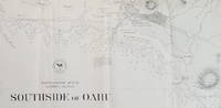
Southside of Oahu.
de [Hawaii: Oahu.] U.S. Navy.
- Usado
- Estado
- Usado
- Cantidad disponible
- 1
- Librería
-
Scarborough, Maine, United States
- Precio
-
EUR 704.62
Mostrar detalles
Descripción:
Scarce Chart of Oahu: Pearl Harbor to Diamond HeadThis is a wonderfully detailed chart of the Pearl Harbor/Honolulu area. It names Diamond Head, Waikiki, Honolulu (with street grid shown), and Pearl Lochs (later, Pearl Harbor) and locates numerous landmarks: school, windmill, leper asylum, prison and several areas with heavy surf and breakers.
The chart appears to be directly derived from a larger, separately issued chart of the same title that covered a somewhat larger area (Hydrographic Office Chart no. 867). The larger chart was first issued in 1880 and updated at least through 1901. While a very short segment of Oahu R.R. is shown just west of Honolulu on the present chart, the much longer stretch of the railway that looped around the northern portion of Pearl Lochs is not shown here as it is on the 1899 edition of the larger map. Since the main portion of the Oahu Railway was completed in late 1889, it suggests that the present map was completed prior to that date. We have been unable to… Leer más
Precio
EUR 704.62
(Map of Caspian Sea & Environs): Nova et Accuratissima Maris Caspii...petri Alexii Filii. Magni Russorum Emper
de Seutter, GM
- Usado
- Estado
- Usado
- Encuadernación
- Unknown
- Cantidad disponible
- 1
- Librería
-
Crozet, Virginia, United States
- Precio
-
EUR 516.72
Mostrar detalles
Descripción:
Augsburg: Seutter, 1740. VG+, copperplate engraving with original hand coloring (color similar to Homann, with whom Seutter apprenticed before going out on his own in about 1707). There is minimal right marginal soling, but the image and color are exceptionally bright. Decorative cartouche, as usual, probably an allegorical representation of imperial Russia. The map measures 19.25x22.5 inches. .
Precio
EUR 516.72
CENT VUES SUISSES remarquables par leur Situation, ou par des Faits Historiques. Dessinn�es et grav�es par Hess, Hegui [sic], K�nig, Lory, Meyer, Wetzel etc.
de Orell, F�ssli (Publishers)
- Usado
- very good
- Tapa dura
- Estado
- Usado - Very Good
- Encuadernación
- Hardcover
- Cantidad disponible
- 1
- Librería
-
Blockley, Gloucestershire, United Kingdom
- Precio
-
EUR 896.72
Mostrar detalles
Descripción:
Zurich: Orell, F�ssli et Comp., 1825 approx). Hardcover. Very Good. Copperplate engravings (100) of Swiss views and domestic scenes by Hess, Hegui, K�nig, Lory, Meyer, Wetzel and others.. Oblong octavo green morocco elaborately gilt on 4 raised bands (lacks lowest spine compartment, tips & hinges worn but sound) All Edges Gilt. Titlepage +[3]pp publisher's list +[4]pp contents + 100 plate leaves printed one side only. Clean and crisp - lovely views with a few genre scenes - wedding, peasants defending land against invaders in 1798, making cheese etc. Minor foxing almost entirely to the margins or blank back of plates, small wormhole at foot of 3 leaves. *A charming work containing views by various artists here collected together for the first time (Lonchamp 3199).
Precio
EUR 896.72
Más fotos
FL
de Wolff, Stephanie and Dorothy Simpson Krause.
- Usado
- Firmado
- Estado
- Usado
- Edición
- Edition of 10 variants
- Encuadernación
- Unknown
- Cantidad disponible
- 1
- Librería
-
Hoover, Alabama, United States
- Precio
-
EUR 751.60
Mostrar detalles
Descripción:
[Boca Raton, Florida]:: Jaffe Center for the Book Arts,, 2015.. Edition of 10 variants. 7.25 x 3.5"; 12 pages. Flutter book. Letterpress printed. Colophon with a map of Florida laser-printed. Cover and pages incorporate letterpress printing on a Vandercook 4 proof press using wood type, metal and collagraph plates. Blind printing of an area map. Printed on Arches 88 paper. Plant inclusion endpapers. Laid in handmade paper wrapper with slit-and-slot closure. Signed and numbered by the artists. Statement: "During Stephanie Wolff's residency at the Jaffe Center for Book Arts, she and Dorothy Krause, the first resident artist, collaborated on this brief ode to Florida. A variety of Pigment prints of vintage documents, maps, photographs and botanicals were transferred onto the pages of this edition of 10 variable copies.
Precio
EUR 751.60
Más fotos
Penbrokshyre [Pembrokeshire],
de John Speed
- Usado
- Estado
- Usado
- Cantidad disponible
- 1
- Librería
-
Plymouth, Devon, United Kingdom
- Precio
-
EUR 588.40
Mostrar detalles
Descripción:
Speed, John : Penbrokshyre described and the sittuations both of Penbroke and St Davids Shewed in due form as they were taken by John Speed. Sold by Bassett and Chiswell. Size approx 510mm x 380mm ( 20 x 15 inches). Early hand coloured double page copper engraved map. From Speed's "The Theatre of the Empire of Great Britain" with English text on verso with a description of the county and town listing. Inset town plans of Penbroke [Pembroke] and Saint Davids. Eleven coats of arms, scale and decorative title cartouche. Very small loss to lower blank margins not affecting printed area. An attractive Speed map in very good condition.
Precio
EUR 588.40
Más fotos
Southside of Oahu.
de [Hawaii: Oahu.] U.S. Navy.
- Usado
- Estado
- Usado
- Cantidad disponible
- 1
- Librería
-
Scarborough, Maine, United States
- Precio
-
EUR 704.62
Mostrar detalles
Descripción:
Scarce Chart of Oahu: Pearl Harbor to Diamond HeadThis is a wonderfully detailed chart of the Pearl Harbor/Honolulu area. It names Diamond Head, Waikiki, Honolulu (with street grid shown), and Pearl Lochs (later, Pearl Harbor) and locates numerous landmarks: school, windmill, leper asylum, prison and several areas with heavy surf and breakers.
The chart appears to be directly derived from a larger, separately issued chart of the same title that covered a somewhat larger area (Hydrographic Office Chart no. 867). The larger chart was first issued in 1880 and updated at least through 1901. While a very short segment of Oahu R.R. is shown just west of Honolulu on the present chart, the much longer stretch of the railway that looped around the northern portion of Pearl Lochs is not shown here as it is on the 1899 edition of the larger map. Since the main portion of the Oahu Railway was completed in late 1889, it suggests that the present map was completed prior to that date. We have been unable to… Leer más
Precio
EUR 704.62

Más fotos
The Sky and the Forest
de Forester, C.S
- Usado
- very good
- Tapa dura
- First
- Estado
- Usado - Very Good
- Estado de la sobrecubierta
- Very Good
- Edición
- First Edition
- Encuadernación
- Hardcover
- Cantidad disponible
- 1
- Librería
-
Salem, Oregon, United States
- Precio
-
EUR 32.78EUR 16.39¡Ahorra EUR 17.44!
Mostrar detalles
Descripción:
C.S. Forester: The Sky and the Forest. Little, Brown and Company, Boston. Stated First Edition First Printing Thus August, 1948. Cover price $2.75. Used. VG BOOK/VG UNCLIPPED DUST JACKET. A story of a central Africa. By C.S. Forester, author of the Admiral Hornblower series.
Precio
EUR 32.78EUR 16.39
¡Ahorra EUR 17.44
!

Más fotos
Plat Book: Pierce County, Wisconsin
de Rhame, A. E
- Usado
- Aceptable
- Tapa blanda
- Estado
- Usado - Fine
- Encuadernación
- Paperback
- Cantidad disponible
- 1
- Librería
-
Woodruff, Wisconsin, United States
- Precio
-
EUR 43.84
Mostrar detalles
Descripción:
1930. Soft Cover. Fine. Unpaginated. Tan colored book is in Fine condition, no sign of wear.
Precio
EUR 43.84
![Alaska and Klondike Region; [With inset of Klondike Region on the Upper Yukon detail] [From an...](https://d3525k1ryd2155.cloudfront.net/h/062/537/1339537062.0.m.jpg)
Alaska and Klondike Region; [With inset of Klondike Region on the Upper Yukon detail] [From an atlas, "Gazetteer of Alaska and Yukon Region " pp. 105 and 106]
de Miller, J. Martin
- Usado
- very good
- Estado
- Usado - Very Good
- Edición
- Unknown
- Cantidad disponible
- 1
- Librería
-
Sebastopol, California, United States
- Precio
-
EUR 36.64
Mostrar detalles
Descripción:
Chicago: J. Martin Miller, 1899. Unknown. Map. Very Good. [Map copyright 1899, printing date of Atlas later] [19.875x15.125in]; Colored map of Alaska with steamer routes from Portland and Seattle, insets of the Klondike Region on the Upper Yukon and Western portion of Aleutian Islands; On verso index of places and names with two large black and white images; Age toning to all edges, water stain marks on bottom, slight printing offset of colors, small chips and closed tears to lower edge;.
Precio
EUR 36.64

Zemepis Sveta - Monsunova Asie
de De La Blache, P. Vidal; Gallois, L
- Usado
- Tapa dura
- Estado
- Usado - Very Good Condition
- Estado de la sobrecubierta
- No Dust Jacket
- Encuadernación
- Hardcover
- Cantidad disponible
- 1
- Librería
-
Oak Point, Texas, United States
- Precio
-
EUR 56.37
Mostrar detalles
Descripción:
Aventinum, Prague, Czechoslovakia, 1930. Hardcover. Very Good Condition/No Dust Jacket. Text entirely in Czech. Geography book on Asia with numerous photographs and maps. 1931 edition also available. Size: 4mo - over 9 3/4" - 12" tall. 400 pp. Pages are yellowed, but are tight and clean. Moderate shelfwear along the spine. Corners are lightly bumped. Quantity Available: 1. Shipped Weight: 3-5 pounds. Category: Travel & Places; Non-English Language::Czech; Pictures of this item not already displayed here available upon request. Inventory No: 001227. . Additional shipping charges may apply.
Precio
EUR 56.37

Zemepis Sveta - Monsunova Asie
de De La Blache, P. Vidal; Gallois, L
- Usado
- Tapa dura
- Estado
- Usado - Very Good Condition
- Estado de la sobrecubierta
- No Dust Jacket
- Encuadernación
- Hardcover
- Cantidad disponible
- 1
- Librería
-
Oak Point, Texas, United States
- Precio
-
EUR 56.37
Mostrar detalles
Descripción:
Aventinum, Prague, Czechoslovakia, 1931. Hardcover. Very Good Condition/No Dust Jacket. Text entirely in Czech. Geography book on Asia with numerous photographs and maps. 1930 edition also available. Size: 4mo - over 9 3/4" - 12" tall. 400 pp. Pages are yellowed, but are tight and clean. Moderate shelfwear along the spine. Corners are lightly bumped. Quantity Available: 1. Shipped Weight: 3-5 pounds. Category: Travel & Places; Non-English Language::Czech; Pictures of this item not already displayed here available upon request. Inventory No: 001228. . Additional shipping charges may apply.
Precio
EUR 56.37

Last Tales
de Dinesen, Isak
- Usado
- very good
- Tapa dura
- First
- Estado
- Usado - Very Good
- Estado de la sobrecubierta
- Good+
- Edición
- First Edition
- Encuadernación
- Hardcover
- Cantidad disponible
- 1
- Librería
-
Salem, Oregon, United States
- Precio
-
EUR 112.74EUR 56.37¡Ahorra EUR 60.00!
Mostrar detalles
Descripción:
Dinesen, Isak: Last Tales, A Collection of Twelve New Tales of Compelling Beauty 1957, Random House. First Edition. Stated First Printing Thus. Used. Very Good/Good+ original red dust jacket, price-clipped. Jacket states 11/57 on front flap. 5 3/4 X
Precio
EUR 112.74EUR 56.37
¡Ahorra EUR 60.00
!

The Adventure of Wrangel Island
de Vilhjalmur Stefansson
- Usado
- good
- Tapa dura
- First
- Estado
- Usado - Good
- Estado de la sobrecubierta
- No DJ Included
- Edición
- First Edition
- Encuadernación
- Hardcover
- Cantidad disponible
- 1
- Librería
-
Salem, Oregon, United States
- Precio
-
EUR 117.33EUR 58.67¡Ahorra EUR 62.44!
Mostrar detalles
Descripción:
The Adventure of Wrangel Island, Alaska (1925 Macmillan 1st Edition) HISTORY OF ALASKA. EXLIB. Good Condition/ No DJ included. Fold-out map affixed to binding at the back of the book has never been opened. The story of the (unsuccessful) attempted colonization of Wrangel Island Alaska. 413 pages plus appendix, Index. Titling is still bright. A clean, solid copy. Scarce.
Precio
EUR 117.33EUR 58.67
¡Ahorra EUR 62.44
!

Seven Pillars Of Wisdom, A Triumph
de Lawrence, T.E
- Usado
- good
- Tapa dura
- First
- Estado
- Usado - Good
- Estado de la sobrecubierta
- No DJ Included
- Edición
- First American Edition
- Encuadernación
- Hardcover
- Cantidad disponible
- 1
- Librería
-
Salem, Oregon, United States
- Precio
-
EUR 117.39EUR 58.70¡Ahorra EUR 62.47!
Mostrar detalles
Descripción:
T.E. Lawrence. SEVEN PILLARS OF WISDOM, A TRIUMPH. AUTOBIOGRAPHY. Privately Printed, 1926. First Published for general circulation 1935. First American Edition. States MCMXXXVI on the title page. Doubleday, Doran & Company, Inc. Garden City, NY. GOOD CONDITION/ NO DUST JACKET IS INCLUDED. 672 pages, indexed. Beige buckram boards. Spine has darkened a bit. 6 7/8 X 9 ½.
Precio
EUR 117.39EUR 58.70
¡Ahorra EUR 62.47
!

Asia from the Best Authorities, Russell, ca.1800
de Russell
- Usado
- Estado
- Usado
- Cantidad disponible
- 1
- Librería
-
Plymouth, Devon, United Kingdom
- Precio
-
EUR 23.54
Mostrar detalles
Descripción:
Russell, J. : Asia from the Best Authorities. Nd but ca.1800. From "A New Geographical, Historical and Commercial Grammar and Present State of Several Kingdoms of the World". Copper engraving. Size approx 200 x 230mm. Two neat folds. Some age colouring to edges, otherwise clean and bright. Includes Arabia, India, Borneo, Japan, China and eastern Russia.
Precio
EUR 23.54

North America from the Best Authorities, Russell, ca.1800
de Russell
- Usado
- Estado
- Usado
- Cantidad disponible
- 1
- Librería
-
Plymouth, Devon, United Kingdom
- Precio
-
EUR 23.54
Mostrar detalles
Descripción:
Russell, J. : A General Map of North America from the Best Authorities. Nd but ca.1800. From "A New Geographical, Historical and Commercial Grammar and Present State of Several Kingdoms of the World." Copper engraving. Size approx 200 x 230mm. Two neat folds. Some age colouring to edges, otherwise very clean and bright.
Precio
EUR 23.54