Descripción:
No Place: No Publisher Bottom right states " By permission of the British Library", Map Number 83670, (2), Plan of the Harbour, Town & Forts of Porto Bello. Near Fine, folded once horizontally, twice vertically. The greatest British success in the War of Jenkin's Ear, fought against the Spanish. Nicely suited for framing, will be mailed folded. . Reprint. Map. Near Fine. 24 3/4" w x 18 3/4" h.
Bowen's Indiana State Atlas; Containing A Separate Maps Of Each County, Showing Section, Township And Range Lines ... Also Containing Maps Of Indiana, The United States And The World ... -
Bowen's Indiana State Atlas; containing a separate maps of each county, showing section, township and range lines ... also containing maps of Indiana, the United States and the world ...
- Usado
- very good
- Tapa dura
- First
Indianapolis, IN: B. F. Bowen & Co., Inc., 1917. SCARCE. Title continues -"containing a separate map of each county, showing section, township and range lines, railroad and interurban lines, churches and school houses and public highways, with a historical sketch of each county ; improved roads shown in colors ; also containing maps of Indiana, the United States and the world ; population of counties, townships, incorporated cities and towns, with estimated population for 1920 ; geographical and other tables ; a history of the growth of the state, and an explanation of the system of land surveys." 15 1/2" x 12", 220 pages.Bound in original black cloth, about Very Good, hinges reinforced with green library tape but still starting to open and a bit loose, cloth rubbed at edges, marginal dampstain along bottom edge, not affecting maps. All maps present and colors bright, Prior owner small name sticker front paste down, 2 page world map at rear with more dampstaining. . First Edition. Cloth. Very Good. Elephant Folio - over 15" - 23" tall.
-
Librería
Dale Steffey Books, ABAA
 (US)
(US)
- Formato/Encuadernación Tapa dura
- Estado del libro Usado - Very Good
- Edición First Edition
- Encuadernación Tapa dura
- Editorial B. F. Bowen & Co., Inc.
- Lugar de publicación Indianapolis, IN
- Fecha de publicación 1917
- Tamaño Elephant Folio - over 15" -
- Size Elephant Folio - over 15" - 23" tall
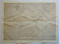
Reproduction Map) Plan of the Harbour, Town & Forts of Porto Bello
- Usado
- near fine
- Tapa blanda
- Estado
- Usado - Near Fine
- Edición
- Reprint
- Encuadernación
- Paperback
- Cantidad disponible
- 1
- Librería
-
Bloomington, Indiana, United States
- Precio
-
EUR 93.20EUR 74.56¡Ahorra EUR 20.00!
Mostrar detalles
Precio
EUR 93.20EUR 74.56
¡Ahorra EUR 20.00
!
![Lithograph Wall Chart] Structural Differential](https://d3525k1ryd2155.cloudfront.net/h/345/509/1338509345.0.m.jpg)
Más fotos
Lithograph Wall Chart] Structural Differential
de Korzybski, Alfred (1879-1950)
- Usado
- near fine
- First
- Estado
- Usado - Near Fine
- Edición
- First Printing
- Cantidad disponible
- 1
- Librería
-
Bloomington, Indiana, United States
- Precio
-
EUR 1,631.00EUR 1,304.80¡Ahorra EUR 350.00!
Mostrar detalles
Descripción:
New York: Rand McNally & Co. , 1949. RARE lithograph wall chart for the device called the "Structural Differential" which Alfred Korzybski patented in 1925 as a means to aid in visualizing the process he called "abstracting". This was to be used as a training device in general semantics, a field of study Korzybski is credited with founding. The chart is Near Fine, rubbed lower right, mounted on two stained wooden dowels with ribbon hanger 18" wide by 38" high. Korzybski's work in semantics heavily influenced science fiction authors such as A.E. Van Vogt, Robert A. Heinlein, Poul Anderson, and H. Beam Piper, as well as L. Ron Hubbard and Joseph W. Campbell. His most famous quote "The map is not the territory" comes from this longer quote "A map is not the territory it represents, but, if correct, it has a similar structure to the territory, which accounts for its usefulness."( Science and Sanity, Korzybski, 1931). OCLC locates no copies; no…
Leer más Precio
EUR 1,631.00EUR 1,304.80
¡Ahorra EUR 350.00
!

Más fotos
Acadian Geology: an Account of the Geological Structure and Mineral Resources of Nova Scotia, and Portions of the Neighobouring Provinces of British America.
de Dawson, John William (Sir)
- Usado
- Tapa dura
- First
- Estado
- Usado - Very Good Minus
- Estado de la sobrecubierta
- No Jacket, As Issued
- Edición
- First Edition
- Encuadernación
- Hardcover
- Cantidad disponible
- 1
- Librería
-
Bloomington, Indiana, United States
- Precio
-
EUR 792.20EUR 633.76¡Ahorra EUR 170.00!
Mostrar detalles
Descripción:
Edinburgh: Oliver and Bord, 1855. RARE in the 1855 First Edition, last seen at auction in 1969 (RBH). Original green embossed cloth with gilt floral arrangement front cover and gilt lettering back, large fold-out color map at rear. Very Good Minus, tears to cloth at head of spine, front hinge opened yet holding nicely, map at rear complete and present, but most of map separated from book, with a 2" chip separated but present. Sir John William Dawson, (1820-1899) ws an important Canadian professor of geology and principal of McGill University for 38 years. He was a Canadian pioneer in the field.of the microscopic studies of fossils, the first British North American trained to be an exploration geologist, and worked in Canada with Charles Lyell, the father of modern geology. . First Edition. Embossed Cloth. Very Good Minus/No Jacket, As Issued. 8vo - over 7¾" - 9¾" tall.
Precio
EUR 792.20EUR 633.76
¡Ahorra EUR 170.00
!
Más fotos
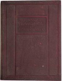
Drummond's Pictorial Atlas of North Carolina
de Drummond, Albert Y. (editor)
- Usado
- near fine
- Tapa dura
- Firmado
- First
- Estado
- Usado - Near Fine
- Estado de la sobrecubierta
- No Jacket, As Issued
- Edición
- First Edition
- Encuadernación
- Hardcover
- Cantidad disponible
- 1
- Librería
-
Bloomington, Indiana, United States
- Precio
-
EUR 559.20EUR 447.36¡Ahorra EUR 120.00!
Mostrar detalles
Descripción:
Charlotte, NC: Albert Y. Drummond, 1924. Presentation Copy, SIGNED AND INSCRIBED BY AUTHOR, editor and publisher Albert Y. Drummond at front end page -" Joseph Hyde Pratt with the compliments of the author. Oct. 1924". SCARCE Association Copy, Col. Joseph Hyde Pratt (1870-1942) was a prominent North Carolina geologist, conservationist, and state and civic leader. In W.W, I he was the colonel in command of the First Battalion of the 105th Engineers, and was part of the famous Thirtieth "Old Hickory" Division, the first to break the Hindenburg Line.(NCpedia). In presentation embossed crushed morocco binding, Near Fine, morocco a bit rubbed, two pages of typed recommendations tipped at rear paste down. Profusely illustrated with black and white photographs, 148 pages. SCARCE in current commerce. . SIGNED AND INSCRIBED BY AUTHOR. First Edition. Crushed Morocco. Near Fine/No Jacket, As Issued. Folio - over 12" - 15" tall. Presentation Copy.
Precio
EUR 559.20EUR 447.36
¡Ahorra EUR 120.00
!
Más fotos
An Epitome of General Ecclesiastical History, from the Earliest Period to the Present Time. With an Appendix, Giving a Condensed History of the Jews
de Marsh, Rev. John
- Usado
- Tapa dura
- Estado
- Usado - Very Good Minus
- Edición
- Eighth Edition
- Encuadernación
- Hardcover
- Cantidad disponible
- 1
- Librería
-
Bloomington, Indiana, United States
- Precio
-
EUR 559.20EUR 447.36¡Ahorra EUR 120.00!
Mostrar detalles
Descripción:
New York: J. Tilden and Co., 1844. SCARCE with both folding maps at front and folding chart present and in Very Good condition. Bound in contemporary full calf, gilt back, marbled edges. Very Good Minus, boards rubbed, hinges starting yet holding well, 1/8" loss of calf at head of spine, moderate toning throughout, prior owner name in ink. Large map at front hand colored, small tears and creases, light toning, 2nd map with 1 small tear, light toning, folding chart at rear with chip to fore edge margin, light toning and creasing. 462 pages, illustrated title page with portrait frontis, followed by 6 engraved plates. . Eighth Edition. Calf. Very Good Minus. 8vo - over 7¾" - 9¾" tall.
Precio
EUR 559.20EUR 447.36
¡Ahorra EUR 120.00
!
Reproduction Map) Plan of the Harbour, Town & Forts of Porto Bello
- Usado
- near fine
- Tapa blanda
- Estado
- Usado - Near Fine
- Edición
- Reprint
- Encuadernación
- Paperback
- Cantidad disponible
- 1
- Librería
-
Bloomington, Indiana, United States
- Precio
-
EUR 93.20EUR 74.56¡Ahorra EUR 20.00!
Mostrar detalles
Descripción:
No Place: No Publisher Bottom right states " By permission of the British Library", Map Number 83670, (2), Plan of the Harbour, Town & Forts of Porto Bello. Near Fine, folded once horizontally, twice vertically. The greatest British success in the War of Jenkin's Ear, fought against the Spanish. Nicely suited for framing, will be mailed folded. . Reprint. Map. Near Fine. 24 3/4" w x 18 3/4" h.
Precio
EUR 93.20EUR 74.56
¡Ahorra EUR 20.00
!
Más fotos
Lithograph Wall Chart] Structural Differential
de Korzybski, Alfred (1879-1950)
- Usado
- near fine
- First
- Estado
- Usado - Near Fine
- Edición
- First Printing
- Cantidad disponible
- 1
- Librería
-
Bloomington, Indiana, United States
- Precio
-
EUR 1,631.00EUR 1,304.80¡Ahorra EUR 350.00!
Mostrar detalles
Descripción:
New York: Rand McNally & Co. , 1949. RARE lithograph wall chart for the device called the "Structural Differential" which Alfred Korzybski patented in 1925 as a means to aid in visualizing the process he called "abstracting". This was to be used as a training device in general semantics, a field of study Korzybski is credited with founding. The chart is Near Fine, rubbed lower right, mounted on two stained wooden dowels with ribbon hanger 18" wide by 38" high. Korzybski's work in semantics heavily influenced science fiction authors such as A.E. Van Vogt, Robert A. Heinlein, Poul Anderson, and H. Beam Piper, as well as L. Ron Hubbard and Joseph W. Campbell. His most famous quote "The map is not the territory" comes from this longer quote "A map is not the territory it represents, but, if correct, it has a similar structure to the territory, which accounts for its usefulness."( Science and Sanity, Korzybski, 1931). OCLC locates no copies; no…
Leer más Precio
EUR 1,631.00EUR 1,304.80
¡Ahorra EUR 350.00
!
Más fotos
Acadian Geology: an Account of the Geological Structure and Mineral Resources of Nova Scotia, and Portions of the Neighobouring Provinces of British America.
de Dawson, John William (Sir)
- Usado
- Tapa dura
- First
- Estado
- Usado - Very Good Minus
- Estado de la sobrecubierta
- No Jacket, As Issued
- Edición
- First Edition
- Encuadernación
- Hardcover
- Cantidad disponible
- 1
- Librería
-
Bloomington, Indiana, United States
- Precio
-
EUR 792.20EUR 633.76¡Ahorra EUR 170.00!
Mostrar detalles
Descripción:
Edinburgh: Oliver and Bord, 1855. RARE in the 1855 First Edition, last seen at auction in 1969 (RBH). Original green embossed cloth with gilt floral arrangement front cover and gilt lettering back, large fold-out color map at rear. Very Good Minus, tears to cloth at head of spine, front hinge opened yet holding nicely, map at rear complete and present, but most of map separated from book, with a 2" chip separated but present. Sir John William Dawson, (1820-1899) ws an important Canadian professor of geology and principal of McGill University for 38 years. He was a Canadian pioneer in the field.of the microscopic studies of fossils, the first British North American trained to be an exploration geologist, and worked in Canada with Charles Lyell, the father of modern geology. . First Edition. Embossed Cloth. Very Good Minus/No Jacket, As Issued. 8vo - over 7¾" - 9¾" tall.
Precio
EUR 792.20EUR 633.76
¡Ahorra EUR 170.00
!
Más fotos
Drummond's Pictorial Atlas of North Carolina
de Drummond, Albert Y. (editor)
- Usado
- near fine
- Tapa dura
- Firmado
- First
- Estado
- Usado - Near Fine
- Estado de la sobrecubierta
- No Jacket, As Issued
- Edición
- First Edition
- Encuadernación
- Hardcover
- Cantidad disponible
- 1
- Librería
-
Bloomington, Indiana, United States
- Precio
-
EUR 559.20EUR 447.36¡Ahorra EUR 120.00!
Mostrar detalles
Descripción:
Charlotte, NC: Albert Y. Drummond, 1924. Presentation Copy, SIGNED AND INSCRIBED BY AUTHOR, editor and publisher Albert Y. Drummond at front end page -" Joseph Hyde Pratt with the compliments of the author. Oct. 1924". SCARCE Association Copy, Col. Joseph Hyde Pratt (1870-1942) was a prominent North Carolina geologist, conservationist, and state and civic leader. In W.W, I he was the colonel in command of the First Battalion of the 105th Engineers, and was part of the famous Thirtieth "Old Hickory" Division, the first to break the Hindenburg Line.(NCpedia). In presentation embossed crushed morocco binding, Near Fine, morocco a bit rubbed, two pages of typed recommendations tipped at rear paste down. Profusely illustrated with black and white photographs, 148 pages. SCARCE in current commerce. . SIGNED AND INSCRIBED BY AUTHOR. First Edition. Crushed Morocco. Near Fine/No Jacket, As Issued. Folio - over 12" - 15" tall. Presentation Copy.
Precio
EUR 559.20EUR 447.36
¡Ahorra EUR 120.00
!
Más fotos
An Epitome of General Ecclesiastical History, from the Earliest Period to the Present Time. With an Appendix, Giving a Condensed History of the Jews
de Marsh, Rev. John
- Usado
- Tapa dura
- Estado
- Usado - Very Good Minus
- Edición
- Eighth Edition
- Encuadernación
- Hardcover
- Cantidad disponible
- 1
- Librería
-
Bloomington, Indiana, United States
- Precio
-
EUR 559.20EUR 447.36¡Ahorra EUR 120.00!
Mostrar detalles
Descripción:
New York: J. Tilden and Co., 1844. SCARCE with both folding maps at front and folding chart present and in Very Good condition. Bound in contemporary full calf, gilt back, marbled edges. Very Good Minus, boards rubbed, hinges starting yet holding well, 1/8" loss of calf at head of spine, moderate toning throughout, prior owner name in ink. Large map at front hand colored, small tears and creases, light toning, 2nd map with 1 small tear, light toning, folding chart at rear with chip to fore edge margin, light toning and creasing. 462 pages, illustrated title page with portrait frontis, followed by 6 engraved plates. . Eighth Edition. Calf. Very Good Minus. 8vo - over 7¾" - 9¾" tall.
Precio
EUR 559.20EUR 447.36
¡Ahorra EUR 120.00
!

Más fotos
The Sky and the Forest
de Forester, C.S
- Usado
- Muy bueno
- Tapa dura
- First
- Estado
- Usado - Muy bueno
- Estado de la sobrecubierta
- Very Good
- Edición
- First Edition
- Encuadernación
- Hardcover
- Cantidad disponible
- 1
- Librería
-
Salem, Oregon, United States
- Precio
-
EUR 32.52EUR 16.26¡Ahorra EUR 17.44!
Mostrar detalles
Descripción:
C.S. Forester: The Sky and the Forest. Little, Brown and Company, Boston. Stated First Edition First Printing Thus August, 1948. Cover price $2.75. Used. VG BOOK/VG UNCLIPPED DUST JACKET. A story of a central Africa. By C.S. Forester, author of the Admiral Hornblower series.
Precio
EUR 32.52EUR 16.26
¡Ahorra EUR 17.44
!

Más fotos
Old Decorative Maps and Charts
de Humphreys, Arthur L
- Usado
- Muy bueno
- Tapa dura
- First
- Estado
- Usado - Very Good
- Estado de la sobrecubierta
- No Jacket
- Edición
- First Edition
- Encuadernación
- Hardcover
- Cantidad disponible
- 1
- Librería
-
Sumner, Iowa, United States
- Precio
-
EUR 41.94
Mostrar detalles
Descripción:
London: London: Halton & Truscott Smith, LTD>. Limited Edition of 1500 copies of which this is number No. 906---Clean, no marks, pages pristine. 79 maps dated 1482-1776 from engravings in the MacPherson Collection. Top Edge Gilt--No DJ Covers rubbed and very slight lean to spine----interior in excellent condition. . Very Good. Hardcover. First Edition. 1926.
Precio
EUR 41.94

Más fotos
Plat Book: Pierce County, Wisconsin
de Rhame, A. E
- Usado
- Aceptable
- Tapa blanda
- Estado
- Usado - Aceptable
- Encuadernación
- Paperback
- Cantidad disponible
- 1
- Librería
-
Woodruff, Wisconsin, United States
- Precio
-
EUR 43.49
Mostrar detalles
Descripción:
1930. Soft Cover. Fine. Unpaginated. Tan colored book is in Fine condition, no sign of wear.
Precio
EUR 43.49
![Alaska and Klondike Region; [With inset of Klondike Region on the Upper Yukon detail] [From an...](https://d3525k1ryd2155.cloudfront.net/h/062/537/1339537062.0.m.jpg)
Alaska and Klondike Region; [With inset of Klondike Region on the Upper Yukon detail] [From an atlas, "Gazetteer of Alaska and Yukon Region " pp. 105 and 106]
de Miller, J. Martin
- Usado
- Muy bueno
- Estado
- Usado - Muy bueno
- Edición
- Unknown
- Cantidad disponible
- 1
- Librería
-
Sebastopol, California, United States
- Precio
-
EUR 36.35
Mostrar detalles
Descripción:
Chicago: J. Martin Miller, 1899. Unknown. Map. Very Good. [Map copyright 1899, printing date of Atlas later] [19.875x15.125in]; Colored map of Alaska with steamer routes from Portland and Seattle, insets of the Klondike Region on the Upper Yukon and Western portion of Aleutian Islands; On verso index of places and names with two large black and white images; Age toning to all edges, water stain marks on bottom, slight printing offset of colors, small chips and closed tears to lower edge;.
Precio
EUR 36.35

Last Tales
de Dinesen, Isak
- Usado
- Muy bueno
- Tapa dura
- First
- Estado
- Usado - Muy bueno
- Estado de la sobrecubierta
- Good+
- Edición
- First Edition
- Encuadernación
- Hardcover
- Cantidad disponible
- 1
- Librería
-
Salem, Oregon, United States
- Precio
-
EUR 111.84EUR 55.92¡Ahorra EUR 60.00!
Mostrar detalles
Descripción:
Dinesen, Isak: Last Tales, A Collection of Twelve New Tales of Compelling Beauty 1957, Random House. First Edition. Stated First Printing Thus. Used. Very Good/Good+ original red dust jacket, price-clipped. Jacket states 11/57 on front flap. 5 3/4 X
Precio
EUR 111.84EUR 55.92
¡Ahorra EUR 60.00
!

Zemepis Sveta - Monsunova Asie
de De La Blache, P. Vidal; Gallois, L
- Usado
- Tapa dura
- Estado
- Usado - Very Good Condition
- Estado de la sobrecubierta
- No Dust Jacket
- Encuadernación
- Hardcover
- Cantidad disponible
- 1
- Librería
-
Oak Point, Texas, United States
- Precio
-
EUR 55.92
Mostrar detalles
Descripción:
Aventinum, Prague, Czechoslovakia, 1931. Hardcover. Very Good Condition/No Dust Jacket. Text entirely in Czech. Geography book on Asia with numerous photographs and maps. 1930 edition also available. Size: 4mo - over 9 3/4" - 12" tall. 400 pp. Pages are yellowed, but are tight and clean. Moderate shelfwear along the spine. Corners are lightly bumped. Quantity Available: 1. Shipped Weight: 3-5 pounds. Category: Travel & Places; Non-English Language::Czech; Pictures of this item not already displayed here available upon request. Inventory No: 001228. . Additional shipping charges may apply.
Precio
EUR 55.92

Zemepis Sveta - Monsunova Asie
de De La Blache, P. Vidal; Gallois, L
- Usado
- Tapa dura
- Estado
- Usado - Very Good Condition
- Estado de la sobrecubierta
- No Dust Jacket
- Encuadernación
- Hardcover
- Cantidad disponible
- 1
- Librería
-
Oak Point, Texas, United States
- Precio
-
EUR 55.92
Mostrar detalles
Descripción:
Aventinum, Prague, Czechoslovakia, 1930. Hardcover. Very Good Condition/No Dust Jacket. Text entirely in Czech. Geography book on Asia with numerous photographs and maps. 1931 edition also available. Size: 4mo - over 9 3/4" - 12" tall. 400 pp. Pages are yellowed, but are tight and clean. Moderate shelfwear along the spine. Corners are lightly bumped. Quantity Available: 1. Shipped Weight: 3-5 pounds. Category: Travel & Places; Non-English Language::Czech; Pictures of this item not already displayed here available upon request. Inventory No: 001227. . Additional shipping charges may apply.
Precio
EUR 55.92

The Adventure of Wrangel Island
de Vilhjalmur Stefansson
- Usado
- Bien
- Tapa dura
- First
- Estado
- Usado - Bien
- Estado de la sobrecubierta
- No DJ Included
- Edición
- First Edition
- Encuadernación
- Hardcover
- Cantidad disponible
- 1
- Librería
-
Salem, Oregon, United States
- Precio
-
EUR 116.40EUR 58.20¡Ahorra EUR 62.44!
Mostrar detalles
Descripción:
The Adventure of Wrangel Island, Alaska (1925 Macmillan 1st Edition) HISTORY OF ALASKA. EXLIB. Good Condition/ No DJ included. Fold-out map affixed to binding at the back of the book has never been opened. The story of the (unsuccessful) attempted colonization of Wrangel Island Alaska. 413 pages plus appendix, Index. Titling is still bright. A clean, solid copy. Scarce.
Precio
EUR 116.40EUR 58.20
¡Ahorra EUR 62.44
!

Seven Pillars Of Wisdom, A Triumph
de Lawrence, T.E
- Usado
- Bien
- Tapa dura
- First
- Estado
- Usado - Bien
- Estado de la sobrecubierta
- No DJ Included
- Edición
- First American Edition
- Encuadernación
- Hardcover
- Cantidad disponible
- 1
- Librería
-
Salem, Oregon, United States
- Precio
-
EUR 116.45EUR 58.23¡Ahorra EUR 62.47!
Mostrar detalles
Descripción:
T.E. Lawrence. SEVEN PILLARS OF WISDOM, A TRIUMPH. AUTOBIOGRAPHY. Privately Printed, 1926. First Published for general circulation 1935. First American Edition. States MCMXXXVI on the title page. Doubleday, Doran & Company, Inc. Garden City, NY. GOOD CONDITION/ NO DUST JACKET IS INCLUDED. 672 pages, indexed. Beige buckram boards. Spine has darkened a bit. 6 7/8 X 9 ½.
Precio
EUR 116.45EUR 58.23
¡Ahorra EUR 62.47
!

North America from the Best Authorities, Russell, ca.1800
de Russell
- Usado
- Estado
- Usado
- Cantidad disponible
- 1
- Librería
-
Plymouth, Devon, United Kingdom
- Precio
-
EUR 23.80
Mostrar detalles
Descripción:
Russell, J. : A General Map of North America from the Best Authorities. Nd but ca.1800. From "A New Geographical, Historical and Commercial Grammar and Present State of Several Kingdoms of the World." Copper engraving. Size approx 200 x 230mm. Two neat folds. Some age colouring to edges, otherwise very clean and bright.
Precio
EUR 23.80