Descripción:
Amsterdam: Covens & Mortier, 1742. Engraving with period outline colour. Some mild soiling and off-set. Guillaume de l'Isle (1675-1726) was the son of a cartographer and pupil of Jean Dominique Cassini, who, among other important contributions, aligned the study of astronomy to the study of geography. Under Cassini's direction, observations were made from locations all over the world that enabled longitudinal calculations to be made with much greater accuracy. De l'Isle carried on this exacting work with remarkable dedication and integrity, constantly revising and improving his maps. While precision was his primary goal, his maps are invariably elegant and attractive. Jean (Johannes) Covens and Corneille (Cornelius) Mortier were brothers-in-law, who carried on the book publishing business established by Pierre Mortier in Amsterdam in 1685. Pierre Mortier's company owed much of its success to his access to French publishers, whose publications he re-issued in handsome editions.The elder Mortier died…
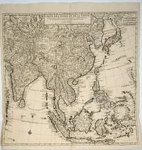
Leer más Carte des Indes et de la Chine / Dressée sur plusieurs Relations particulieres Rectifiées par quelques Observations par Guillaume de l'Isle de l'Academie Royale des Sciences. Map de De L'Isle. Covens & Mortier - 1720
de De L'Isle. Covens & Mortier
Carte des Indes et de la Chine / Dressée sur plusieurs Relations particulieres Rectifiées par quelques Observations par Guillaume de l'Isle de l'Academie Royale des Sciences. Map
de De L'Isle. Covens & Mortier
- Usado
Amsterdam: Chez Jean Covens et Corneille Mortier, 1720. Very good condition. A fine example of this highly detailed map of the Far East covering from Japan and Southeast Asia to Uzbekistan and India. Areas mapped include China, India, Japan, New Guinea, Timor, Taiwan, Malaysia, Thailand, Vietnam, Burma, Philippines, Sri Lanka and many of the "Stans" in the west. The map is based on the earlier work of Guillaume De L'Isle. Covens & Mortier specialized in publishing French geographers including De L'Isle, Jaillot, Janssonius, and Sanson. They also reissued atlases, for example a 1725 reissue of Frederik de Wit's Atlas Major and an atlas, with additions, from the works of Guillaume De L'Isle. They also purchased Pieter van der Aa's plates in 1730. At their high point, they had the largest collection of geographic prints ever assembled in Amsterdam. Handsome copper engraving, b&w as issued, 24 x 24 1/4", two original folds, bright and clean.
-
Librería
Antipodean Books, Maps & Prints
 (US)
(US)
- Estado del libro Usado - Very good condition
- Cantidad disponible 1
- Editorial Chez Jean Covens et Corneille Mortier
- Lugar de publicación Amsterdam
- Fecha de publicación 1720
![[Sri Lanka] Insula Ceilon olim Taprobana. Carte de L'Isle de Ceylan](https://d3525k1ryd2155.cloudfront.net/h/187/441/780441187.1.m.jpg)
[Sri Lanka] Insula Ceilon olim Taprobana. Carte de L'Isle de Ceylan
de DE L'ISLE, Guillaume and COVENS & MORTIER
- Usado
- Estado
- Usado
- Cantidad disponible
- 1
- Librería
-
New York, New York, United States
- Precio
-
EUR 329.21
Mostrar detalles
Precio
EUR 329.21

L'Hemisphere Meridional pour voir plus distinctement Les Terres Australes. Par Guillaume De l'Isle, del Academic Rledes Sciences. Ou se voyent les Nouvelles decouvertes faites en 1739 au Dus du Cap de Bonne Esperance par les Ordres de M. De La Companie Des Indes, Dressee sur la memories et sur la Carte Originale de M. De Lozier bouvet, charge de cette Expedition
de MAP]. De L'ISLE, Guillaume & Covens & Mortier
- Usado
- near fine
- Estado
- Usado - Near Fine
- Cantidad disponible
- 1
- Librería
-
Ottawa, Ontario, Canada
- Precio
-
EUR 584.38
Mostrar detalles
Descripción:
Amsterdam. Chez Jean Covens et Corneille Mortier, (After De L'Isle with updating & text after French Compagnie des Indes in 1739). 1740. No Binding. Near Fine. 47 x 53 cm. (18«" x 21"), plus good wide margins, original outline coloured, small library stamp on the verso, there is an area of slight foxing or transfer, about one inch wide and five inches long at the fold on the top half but overall a fine copy. Southern Hemisphere & Antarctica. From:Atlas Nouveau, contenant toutes les parites du monde. Parallel text in French and Dutch, in the margins. Small inset "Plan et vue des terres du Cap de la Circoncision [ie, Bouvert Island]. Cf. Phillips. Atlases. (3),595. Fitzgerald M-206.
Precio
EUR 584.38

Más fotos
Theatre de la Guerre Dans la Petite Tartarie, La Crimee , la Mer Noire &c. Dresee sur un Grand Nombre de Carte Manuscrites et d'Itineraires
de De L'Isle, Guillaume/Covens, Jean & Mortier, Cornelius
- Usado
- Estado
- Usado
- Cantidad disponible
- 1
- Librería
-
Port Hope, Ontario, Canada
- Precio
-
EUR 587.88
Mostrar detalles
Descripción:
18-3/4 x 24"-47.6 x 60.9 cm. Hand coloured copper engraved map. Small split to lower centrefold otherwise fine. A very detailed map of Ukraine, Russia, Crimea and countries surrounding the Black Sea during the Russian-Turkish war 1736-39. Historical notes indicating where archaeological remains relating to Alexander the Great are indicated as well as topographical and cultural observations.
Precio
EUR 587.88
![[Burgundy] Partie Septrionale Du Duche De Bourgogne Par Guillaume Del 'Isle de l' Academie Royale...](https://d3525k1ryd2155.cloudfront.net/h/265/955/1255955265.1.m.jpg)
Más fotos
[Burgundy] Partie Septrionale Du Duche De Bourgogne Par Guillaume Del 'Isle de l' Academie Royale des Sciences.[and] Partie Meridonale du Duche de Bourgogne
de DE L'ISLE, Guillaume (1675-1726/ Cóvens & Mortier
- Usado
- Estado
- Usado
- Cantidad disponible
- 1
- Librería
-
New York, New York, United States
- Precio
-
EUR 611.39
Mostrar detalles
Descripción:
Amsterdam: Cóvens & Mortier, 1742. Engraved with period outline colour. Discolouration at center fold. Collection stamp on verso. A handsome, two-sheet map of Burgundy. This pair of maps of the ancient kingdom of Burgundy comes from a Dutch edition of De L'Isle's work entitled, Atlas Nouveau, Contenant Toutes Les Parties Du Monde, Ou sont exactement Remarquées les Empires, Monarchies, Royaumes, Etats, Republiques &c. Par Guillaume de l'Isle. Premier Géographe de sa Majesté. It was published by Covens and Mortier, brothers-in-law who continued the firm established by Pierre Mortier. Guillaume de l'Isle (1675-1726) was son of a cartographer and a pupil of Jean Dominique Cassini, who among other important contributions, aligned the study of astronomy to the study of geography. Under Cassini's direction, observations were made from locations all over the world that enabled longitudinal calculations to be made with much greater accuracy. De l'Isle carried on this exacting work with remarkable…
Leer más Precio
EUR 611.39

Carte de la Champagne et des Pays Voisins où l'on voit la Generalité de Chalons, partie de celle de Soissons, &c. Par Guillaime De L'Isle de l'Académie Royale des Sciences. (antique map of Champagne)
de De l'Isle, Guillaume (Delisle, De Lisle) (Covens & Mortier)
- Usado
- First
- Estado
- Usado
- Cantidad disponible
- 1
- Librería
-
Sitges (BCN), Barcelona, Spain
- Precio
-
EUR 705.45
Mostrar detalles
Descripción:
Amsterdam: J. Covens et C. Mortier, 1742. A BEAUTIFUL HAND-COLORED MAP OF CHAMPAGNE and nearby areas. 48 x 63 cm (plate), 56 x 69 cm (sheet). The areas described in the title are FULLY COLORED BY A CONTEMPORARY HAND. Printed on fine, thick laid paper. Reverse blank. A fine impression. A few tiny marginal tears, else A PRISTINE EXAMPLE, with the paper FINE AND BRIGHT. Very scarce in such fine condition.
Precio
EUR 705.45

Más fotos
Carte D'Amerique Dressée pour l'Usage du Roy...1739. America Accurate in Imperia, Regna, Status & Populos Divisa, ad Usum Ludovici XV, Galliarum Regis
de DE L'ISLE, Guillaume and Covens & Mortier
- Usado
- Estado
- Usado
- Cantidad disponible
- 1
- Librería
-
New York, New York, United States
- Precio
-
EUR 752.48
Mostrar detalles
Descripción:
Amsterdam: Covens & Mortier, 1742. Engraving with period outline colour. Some mild soiling. Discolouration at centerfold. An elegant map of North and South America, the most accurate to date, produced for the "usage du Roy," Louis XV. Guillaume de l'Isle (1675-1726) was the son of a cartographer and pupil of Jean Dominique Cassini, who, among other important contributions, aligned the study of astronomy to the study of geography. Under Cassini's direction, observations were made from locations all over the world that enabled longitudinal calculations to be made with much greater accuracy. De l'Isle carried on this exacting work with remarkable dedication and integrity, constantly revising and improving his maps. While precision was his primary goal, his maps are invariably elegant and attractive. Jean (Johannes) Covens and Corneille (Cornelius) Mortier were brothers-in-law, who carried on the book publishing business established by Pierre Mortier in Amsterdam in 1685. Pierre Mortier's company owed…
Leer más Precio
EUR 752.48

Carte du Canada ou de la Nouvelle France
de De L'Isle; Covens & Mortier
- Usado
- Estado
- Usado - Very Good, central fold reinforced
- Cantidad disponible
- 1
- Librería
-
Toronto, Ontario, Canada
- Precio
-
EUR 2,351.50
Mostrar detalles
Descripción:
Amsterdam: Covens & Mortier, 1730. Very Good, central fold reinforced. Notes: Second state."De L'Isle's careful research resulted in the first mpa of Canada to present the whole of the Great Lakes correctly. In addition, the postion of the lakes relative to Hudson Bay is also correct, and the Avalon Peninsula is shown much more realistically than on previous maps of Canada. Of considerable significance, the geography of the coastal regions of James and Hudson Bays, together with their major river systems, is presented by De L'Isle with a surprising degree of accuracy." (Kershaw), Size : 495x575 (mm), 19.49x22.64 (Inches), Coloring: Hand Colored in Outline, Reference: Kershaw vol.1, 318, Category: Maps Canada;
Precio
EUR 2,351.50

Mappe Monde a l'usage du Roy
de De L'Isle; Covens Mortier
- Usado
- Estado
- Usado - Very Good, mounted on acid free tissue paper for long term preservation.
- Cantidad disponible
- 1
- Librería
-
Toronto, Ontario, Canada
- Precio
-
EUR 2,821.80
Mostrar detalles
Descripción:
Amsterdam, 1730. Very Good, mounted on acid free tissue paper for long term preservation.. Size : 445x685 (mm), 17.5x27 (Inches), Coloring: Hand Colored in Outline, Category: Maps World
Precio
EUR 2,821.80