Ver a tamaño completo.


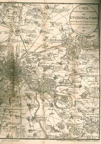
Carte topographique et statistique des environs de Paris, donnant la population de chaque commune, avec des notes sur ce qu''il y a de plus curieux à y voir
de Maire, N.M
- Usado
- Estado
- Ver descripción
- Librería
-
Cambridge, Massachusetts, United States
Formas de pago aceptadas
Sobre este artículo
Early 19th century map of the suburbs of Paris, from Montmorency in the north to Vissons and Villeneuve in the south, and from St. Germain and Versailles in the west to Noisy-le-Grand in the east, with towns and sites including chateaux and parks marked with short captions and elevations. Very minor toning along creases. 16mo. Boards. Abrasions, rubbing, loss to paper along spine, some splitting to boards, pen notation to inside front cover. Paris (Rosselin) 1835. Not much is known about the biography of N.M. Maire. In 1808, he self-published "La topographie de Paris, ou, Plan détaillé de la ville de Paris et de ses faubourgs", a small city atlas of 20 maps and 104 pages of listings of streets, public offices, hotels, hospitals, and other points of interest. Circa 1821 he published the first edition of his "Atlas administratif de Paris", with fourteen copies of the same map of Paris, each devoted to a specific subject including lighting districts, markets, sewers, and firefighting districts. Very scarce; although WorldCat has listings for an earlier and later version of this map, as of December 2017 we were not able to locate a single listing for the 1835 edition.
Reseñas
(¡Iniciar sesión or Crear una cuenta primero!)
Detalles
- Librería
- Bernett Rare Books Inc
 (US)
(US)
- Inventario del vendedor #
- 48782
- Título
- Carte topographique et statistique des environs de Paris, donnant la population de chaque commune, avec des notes sur ce qu''il y a de plus curieux à y voir
- Autor
- Maire, N.M
- Estado del libro
- Usado
- Cantidad disponible
- 1
Términos de venta
Bernett Rare Books Inc
30 day return guarantee, with full refund including shipping costs for up to 30 days after delivery if an item arrives misdescribed or damaged.
Sobre el vendedor
Bernett Rare Books Inc
Miembro de Biblio desde 2008
Cambridge, Massachusetts
Sobre Bernett Rare Books Inc
Bernett Rare Books specializes in rare and out-of-print scholarly books on the History of Art and Architecture from antiquity to the present. Since 1944 we have been helping institutional libraries and individuals build their collections.
Glosario
Algunos términos que podrían usarse en esta descripción incluyen:
- Rubbing
- Abrasion or wear to the surface. Usually used in reference to a book's boards or dust-jacket.
- Spine
- The outer portion of a book which covers the actual binding. The spine usually faces outward when a book is placed on a shelf....
- Worldcat
- Worldcat is a collaborative effort produced by OCLC (Online Computer Library Center) and supported and used by 72,000 libraries...
- First Edition
- In book collecting, the first edition is the earliest published form of a book. A book may have more than one first edition in...