Ver a tamaño completo.
Chapman's Wisconsin A Sectional Map with the Most Recent Surveys.
de Chapman, Silas
- Usado
- Estado
- Ver descripción
- Librería
-
Florham Park, New Jersey, United States
Formas de pago aceptadas
Sobre este artículo
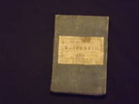
Lithographed folding pocket map, hand colored in outline, 55 x 77 cm (21" x 30 1/4"), cloth covers (5 1/2" x 3 1/2"), paper cover label. Cloth covers and paper label worn, with some stains, some splits at folds, including a long split extending in from right margin, some minor margin chips, normal aging; otherwise about very good. Silas Chapman (1813-1899) was born in Massachusetts, and would become a prominent midwestern map publisher. His firm was very active during the 1850-1870 period publishing many wall and pocket maps of midwestern locations. This map is a colorful sample of an early map of Wisconsin, which was originally published in 1853. The map was published about seven years after Wisconsin became a state, and it essentially features about two thirds of what is currently Wisconsin. On this map the most northern county is Polk. The Northern part of the sate is not shown. geographicus website.
Reseñas
(¡Iniciar sesión or Crear una cuenta primero!)
Detalles
- Librería
- Nicholas D. Riccio Rare Books & Prints
 (US)
(US)
- Inventario del vendedor #
- 106022
- Título
- Chapman's Wisconsin A Sectional Map with the Most Recent Surveys.
- Autor
- Chapman, Silas
- Estado del libro
- Usado
- Cantidad disponible
- 1
- Editorial
- Silas Chapman,
- Lugar de publicación
- Milwaukee:
- Fecha de publicación
- 1855.
- Palabras clave
- Wisconsin. Folding Maps.
Términos de venta
Nicholas D. Riccio Rare Books & Prints
30 day return guarantee, with full refund including shipping costs for up to 30 days after delivery if an item arrives misdescribed or damaged.
Sobre el vendedor
Nicholas D. Riccio Rare Books & Prints
Miembro de Biblio desde 2011
Florham Park, New Jersey
Sobre Nicholas D. Riccio Rare Books & Prints
Established in 1999 we specialize in Americana, African Americana, Natural History, Travel & Exploration, Science & Medicine, and Maps & Atlases
Glosario
Algunos términos que podrían usarse en esta descripción incluyen:
- Cloth
- "Cloth-bound" generally refers to a hardcover book with cloth covering the outside of the book covers. The cloth is stretched...