
Ver a tamaño completo.
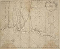
A CHART OF YE COAST OF ANGOLA FROM YE R. AMBRIS TO MOUNT NEGRO
de Mount, William, Page, Thomas
- Usado
- Estado
- Ver descripción
- Librería
-
Port Hope, Ontario, Canada
Formas de pago aceptadas
Sobre este artículo
London: : From "The English Pilot: Part V" Sixth edition. Mount and Page, , 1761. 16-3/4" x 20-1/2"- 42.5 x 52 cm. Copper engraved map with hand colouring. Light overall browning with darker areas to corners, generally good . An interesting coastal chart engraved by Francis Lamb showing rhumb lines, from the Congo to Mount Negro in Mataman (now Namibia).
Reseñas
(¡Iniciar sesión or Crear una cuenta primero!)
Detalles
- Librería
- Webster's Fine Books & Maps, ABAC, ILAB
 (CA)
(CA)
- Inventario del vendedor #
- 1386
- Título
- A CHART OF YE COAST OF ANGOLA FROM YE R. AMBRIS TO MOUNT NEGRO
- Autor
- Mount, William, Page, Thomas
- Estado del libro
- Usado
- Cantidad disponible
- 1
- Editorial
- From "The English Pilot: Part V" Sixth edition. Mount and Page,
- Lugar de publicación
- London:
- Fecha de publicación
- 1761
- Peso
- 0.00 libras
- Catálogos del vendedor
- Antiquarian Map-Africa;
Términos de venta
Webster's Fine Books & Maps, ABAC, ILAB
All items guaranteed as catalogued. We accept Visa, US$, Sterling or C$ cheques, international or postal money orders. Returns if notified within 7 days of receipt and items must be returned in condition they were received.
Sobre el vendedor
Webster's Fine Books & Maps, ABAC, ILAB
Miembro de Biblio desde 2004
Port Hope, Ontario
Sobre Webster's Fine Books & Maps, ABAC, ILAB
Webster's Fine Books & Maps are members of the Antiquarian Booksellers Association of Canada (ABAC),The International League of Antiquarian Booksellers (ILAB) and International Map Collectors Society (IMCoS) . We deal in Books on travel and antiquarian & maps of all geographical areas but particularly of North America and of Islands. We welcome want lists and can provide appraisals for probate or insurance purposes.
