Descripción:
New. .
[Complete Map of Brazil]. Amer. Merid. Partie du Bresil... [17 Maps] de Vandermaelen, Philippe - 1827
de Vandermaelen, Philippe
![[Complete Map of Brazil]. Amer. Merid. Partie du Bresil... [17 Maps] de Vandermaelen, Philippe - 1827](https://d3525k1ryd2155.cloudfront.net/h/052/584/614584052.0.m.2.jpg)
[Complete Map of Brazil]. Amer. Merid. Partie du Bresil... [17 Maps]
de Vandermaelen, Philippe
- Usado
[Bruxelles]: [Ph. Vandermaelen], 1827. First edition. A very good sharp set, housed in a clamshell box.. 17 sheets. Hand-colored lithographic maps. 47 x 57 cm. The Empire of Brazil on a grand scale, printed shortly after Pedro declared the independence of Brazil, but before the conclusion of the Cisplatine War against the United Provinces of the Río de la Plata (Argentina) which cost her Uruguay. Sheets from Phillipe Vandermaelen, Atlas universel de geographie physique, politique, statistique et mineralogique..., a magnificent and ground breaking six volume atlas of the entire world, which was the first Atlas to use lithography, to show the entire world using such a large uniform scale, approximately 26 miles to the inch, and which was designed to be joined together into a three-dimensional globe with a diameter of aboout 25 feet. Includes all of Brazil with some surrounding areas: 1. Amer. Merid. no. 9. Partie de la Colombie et du Bresil. Parts of Peru, Colombia, and Brazil. 2. Amer. Merid. 10. Partie du Bresil. Amazonas region, Brazil. 3. Amer. Merid. 11. Partie du Bresil. Parts of Amazonas, Para and Amapa. 4. Amer. Merid. 12. Partie du Bresil. Covers parts of Para and Maranhao. 5. Amer. Merid. 13. Partie du Bresil. Parts of Piaui, Ceara and Rio Grande do Norte. Text: Note sur le Bresil ... Pour la suite voyez la carte no. 32. 6. Amer. Merid. 15. Partie du Perou et du Bresil. Parts of Peru, Brazil and northern Bolivia. 7. Amer. Merid. 16. Partie du Bresil. Parts of Brazil and northern Bolivia. 8. Amer. Merid. 17. Partie du Bresil. Parts of Mato Grosso, Tocantins, Amazonas, and Para. 9. Amer. Merid. 18. Partie du Bresil... Parts Tocantins, Bahia, Maranhao, and Piaui. 10. Amer. Merid. 19. Partie du Bresil. Parts of northeastern Brazil. 11. Amer. Merid. 22. Partie du Bresil. Part of Santa Cruz, Bolivia and Mato Grosso and Mato Grosso do Sul, Brazil. 12. Amer. Merid. 23. Partie du Bresil. Parts of Goias, Federal District, Minas Gerais, and Tocantins. 13. Amer. Merid. 24. Partie du Bresil. Parts of Bahia and Minas Gerais with coast soundings. 14. Amer. Merid. 27. Partie du Bresil. Part of southern Brazil. 15. Amer. Merid. 28. Partie du Bresil. Parts of Sao Paulo, Minas Gerais, Espirito Santo, and Rio de Janeiro states. 16. Amer. Merid. 32. Partie du Bresil. Part of southern Brazil. Text box: Note sur le Bresil. Pour le commencement voyez la carte no. 13. 17. Amer. Merid. 35. Partie du Bresil. Parts of Uruguay, Rio Grande do Sul, Brazil, and Buenos Aires province, Argentina (an eighteenth sheet, No.36, was labeled 'Partie du Bresil, but in fact only included parts of Argentina and Chile). If joined together the map would measure approximately 9 x 7 feet. Phillips, 749. Amer. Geol. Soc., Catalogue of Maps of Hispanic America: III, p. 172. Sabin 43762.
-
Librería
Kaaterskill Books, ABAA/ILAB
 (US)
(US)
- Estado del libro A very good sharp set, housed in a clamshell box.
- Cantidad disponible 1
- Edición First edition
- Editorial [Ph. Vandermaelen]
- Lugar de publicación [Bruxelles]
- Fecha de publicación 1827
- Palabras clave Brazil, , Latin America, South America, Brazil, maps, cartography, Bresil, Map

Foto de archivo: la portada puede ser diferente
Dictionnaire Gographique de la Province de Namur: Le Docteur Meisser Est Charg de la Rdaction Et de la Correspondance... (French Edition)
de Vandermaelen, Philippe
- Nuevo
- Estado
- New
- ISBN 10 / ISBN 13
- 9781275995208 / 1275995209
- Cantidad disponible
- 1
- Librería
-
Bensalem, Pennsylvania, United States
- Precio
-
EUR 36.66
Mostrar detalles
Precio
EUR 36.66
Foto de archivo: la portada puede ser diferente
Dictionnaire Géographique De La Province De Liège: Précédé D'un Fragment Du Mémorial De L'établissement Géographique De Bruxelle... (French Edition)
de Philippe Vandermaelen, Meisser, Philippe Marie Guillaume Maelen (Creator)
- Usado
- good
- Tapa blanda
- Estado
- Usado - Good
- Encuadernación
- Paperback
- ISBN 10 / ISBN 13
- 9781272048211 / 1272048217
- Cantidad disponible
- 1
- Librería
-
HOUSTON, Texas, United States
- Precio
-
EUR 42.19
Mostrar detalles
Descripción:
Nabu Press, 2011-11-23. Paperback. Good.
Precio
EUR 42.19

Foto de archivo: la portada puede ser diferente
Dictionnaire Geographique Du Luxembourg...
de Philippe Vandermaelen
- Nuevo
- Tapa blanda
- Estado
- New
- Encuadernación
- Paperback
- ISBN 10 / ISBN 13
- 9781018807324 / 1018807322
- Cantidad disponible
- 10
- Librería
-
Southport, Merseyside, United Kingdom
- Precio
-
EUR 35.31
Mostrar detalles
Descripción:
Paperback / softback. New.
Precio
EUR 35.31

Foto de archivo: la portada puede ser diferente
Dictionnaire Geographique Du Luxembourg...
de Philippe Vandermaelen
- Nuevo
- Tapa dura
- Estado
- New
- Encuadernación
- Hardcover
- ISBN 10 / ISBN 13
- 9781018802688 / 1018802681
- Cantidad disponible
- 10
- Librería
-
Southport, Merseyside, United Kingdom
- Precio
-
EUR 45.31
Mostrar detalles
Descripción:
Hardback. New.
Precio
EUR 45.31

Foto de archivo: la portada puede ser diferente
Campagne De 1815: Waterloo... (French Edition)
de Charras, Jean-Baptiste-Alphonse; Vandermaelen, Philippe
- Nuevo
- Tapa dura
- Estado
- New
- Encuadernación
- Hardcover
- ISBN 10 / ISBN 13
- 9780353781733 / 0353781738
- Cantidad disponible
- 5
- Librería
-
campbelltown, Florida, United States
- Precio
-
EUR 44.42
Mostrar detalles
Descripción:
Wentworth Press. hardcover. New. 6x1x9. Brand New Book in Publishers original Sealing
Precio
EUR 44.42
Foto de archivo: la portada puede ser diferente
Dictionnaire Gographique de la Province de Namur: Le Docteur Meisser Est Charg de la Rdaction Et de la Correspondance... (French Edition)
de Vandermaelen, Philippe
- Usado
- Estado
- UsedLikeNew
- ISBN 10 / ISBN 13
- 9781275995208 / 1275995209
- Cantidad disponible
- 1
- Librería
-
Bensalem, Pennsylvania, United States
- Precio
-
EUR 138.71
Mostrar detalles
Descripción:
UsedLikeNew. Remainder mark
Precio
EUR 138.71
Foto de archivo: la portada puede ser diferente
Dictionnaire Gographique de la Province de Namur: Le Docteur Meisser Est Charg de la Rdaction Et de la Correspondance... (French Edition)
de Vandermaelen, Philippe
- Usado
- Estado
- UsedVeryGood
- ISBN 10 / ISBN 13
- 9781275995208 / 1275995209
- Cantidad disponible
- 1
- Librería
-
Bensalem, Pennsylvania, United States
- Precio
-
EUR 138.71
Mostrar detalles
Descripción:
UsedVeryGood. Minor shelf wear
Precio
EUR 138.71

AMER. SEP. DECOUVERTES BOREALES No. 8 [c. 1827]
de Vandermaelen, Philippe Marie Guillaume
- Usado
- Estado
- Usado
- Cantidad disponible
- 1
- Librería
-
Port Hope, Ontario, Canada
- Precio
-
EUR 160.68
Mostrar detalles
Descripción:
18.5" x 22"-46.9 x 55.8 cm. . Colour. A nice crisp copy with wide margins. An interesting topographical chart showing the profile of the Canal of Huehuetca in Mexico and its funciotn of preserving flooding in Mexico city.
Precio
EUR 160.68
OCEANIQUE. ILES DES AMIS No. 47
de Vandermaelen, Philippe Marie Guillaume
- Usado
- Estado
- Usado - A nice crisp copy with wide margins.
- Cantidad disponible
- 1
- Librería
-
Port Hope, Ontario, Canada
- Precio
-
EUR 165.41
Mostrar detalles
Descripción:
Lithograph with hand colouring. An interesting chart showing Tonga or "The Friendly Islands" with extensive description of he flora and fauna of the region. Vandermaelen's Atlas Universel was the first Atlas to use the lithographic process throughout. Phillips, 749; Koeman Vdm 1; National Maritime Museum, 179
Precio
EUR 165.41
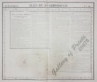
Océanique: Isles du Scarborough. 'pl. 16 Note sur le nouv. Hollande. Pour le commencement voyez la carte no. 29 ... Pour la suite voyez la carte no. 17. [Notes on New Holland. For the beginning please go to map no. 29….For the continuation please see map no. 17]
de Philippe Marie Guillaume Vandermaelen / Henri Ode [lith.]
- Usado
- Estado
- Usado
- Cantidad disponible
- 1
- Librería
-
Paranaque City, Metro Manila, Philippines
- Precio
-
EUR 141.78
Mostrar detalles
Descripción:
RARE original-colour lithograph, features long text on "New Holland pl. 29" apparently due to space reasons(bare ocean….). RARE map of Kiribati with the Gilbert Islands, from 'Atlas Universel de Geographie...', (Oceanique no. 16). This 6 vol. Atlas contains 382 lithographed mapsheets and 40 plates of statistical data by Henri Ode (mostly hand-coloured in outline). The maps in the atlas constitute not only the first atlas of the world on a uniform scale, but also the first lithograph atlas. Constructed on a modified conical projection, if assembled, they form a 7,75 m diameter globe, although only one such was known to have been assembled, by the author himself, and requiring a specially designed room. Map shows the Gilbert Islands, now main part of Republic of Kiribati. But the main feature of this map is the extensive description of Australia, referring to map no. 29. Prime meridian: Paris. Reference: atlas: Koeman III, Vdm 1; Phillips, Atlases 749. Condition: with center fold as issued, with some…
Leer más Precio
EUR 141.78