Descripción:
United Kingdom: William Mackenzie. This is the 1894 coloured maps of Kent taken from 'The comprehensive gazetteer of England and Wales' edited by J.H.F. Brabner, published in 1894. Each map measures 32 x 25 cms and has a centre fold . Very Good. Soft cover. 1894.
Comprehensive Gazetter of England and Wales, Vol I de J.H.F. Brabner
de J.H.F. Brabner

Comprehensive Gazetter of England and Wales, Vol I
de J.H.F. Brabner
- Usado
- good
- Tapa dura
William Mackenzie, 1111. Hardcover. Good. 352 pages. No dust jacket. Red cloth half-bound in leather with gold lettering to front and spine. Gilt top edge text block. Pages remain clear with light tanning and foxing throughout and some occasional marking. Heavier tanning to endpapers. Binding remains firm. Boards are moderately marked and have wear to edges, bumping to corners, some crushing and splitting to spine.
-
Librería
World of Rare Books
 (GB)
(GB)
- Formato/Encuadernación Tapa dura
- Estado del libro Usado - Good
- Cantidad disponible 1
- Encuadernación Tapa dura
- Editorial William Mackenzie
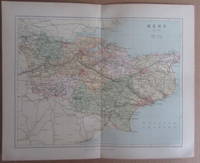
MAP OF KENT - 1894
de J.H.F. Brabner
- Usado
- very good
- Tapa blanda
- Estado
- Usado - Very Good
- Encuadernación
- Paperback
- Cantidad disponible
- 1
- Librería
-
South Kelsey, Lincolnshire, United Kingdom
- Precio
-
EUR 4.73
Mostrar detalles
Precio
EUR 4.73
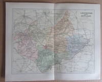
MAP OF LEICESTERSHIRE AND RUTLAND- 1894
de J.H.F. Brabner
- Usado
- very good
- Tapa blanda
- Estado
- Usado - Very Good
- Encuadernación
- Paperback
- Cantidad disponible
- 1
- Librería
-
South Kelsey, Lincolnshire, United Kingdom
- Precio
-
EUR 4.73
Mostrar detalles
Descripción:
United Kingdom: William Mackenzie. This is the 1894 coloured maps of Leicestershire and Rutland taken from 'The comprehensive gazetteer of England and Wales' edited by J.H.F. Brabner, published in 1894. Each map measures 32 x 25 cms and has a centre fold . Very Good. Soft cover. 1894.
Precio
EUR 4.73
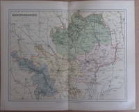
MAP OF HERTFORDSHIRE - 1894
de J.H.F. Brabner
- Usado
- very good
- Tapa blanda
- Estado
- Usado - Very Good
- Encuadernación
- Paperback
- Cantidad disponible
- 1
- Librería
-
South Kelsey, Lincolnshire, United Kingdom
- Precio
-
EUR 4.73
Mostrar detalles
Descripción:
United Kingdom: William Mackenzie. This is the 1894 coloured maps of Hertfordshire taken from 'The comprehensive gazetteer of England and Wales' edited by J.H.F. Brabner, published in 1894. Each map measures 32 x 25 cms and has a centre fold . Very Good. Soft cover. 1894.
Precio
EUR 4.73
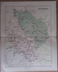
MAP OF HUNTINGDON - 1894
de J.H.F. Brabner
- Usado
- very good
- Tapa blanda
- Estado
- Usado - Very Good
- Encuadernación
- Paperback
- Cantidad disponible
- 1
- Librería
-
South Kelsey, Lincolnshire, United Kingdom
- Precio
-
EUR 4.73
Mostrar detalles
Descripción:
United Kingdom: William Mackenzie. This is the 1894 coloured maps of Huntingdon taken from 'The comprehensive gazetteer of England and Wales' edited by J.H.F. Brabner, published in 1894. Each map measures 32 x 25 cms and has a centre fold . Very Good. Soft cover. 1894.
Precio
EUR 4.73
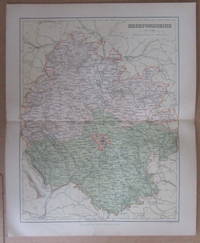
MAP OF HEREFORDSHIRE- 1894
de J.H.F. Brabner
- Usado
- good
- Tapa blanda
- Estado
- Usado - Good
- Encuadernación
- Paperback
- Cantidad disponible
- 1
- Librería
-
South Kelsey, Lincolnshire, United Kingdom
- Precio
-
EUR 4.73
Mostrar detalles
Descripción:
United Kingdom: William Mackenzie. This is the 1894 coloured maps of Herefordshire taken from 'The comprehensive gazetteer of England and Wales' edited by J.H.F. Brabner, published in 1894. Each map measures 32 x 25 cms and has a centre fold. Very minor slit to bottom margin edge approx 1 cm . Good. Soft cover. 1894.
Precio
EUR 4.73
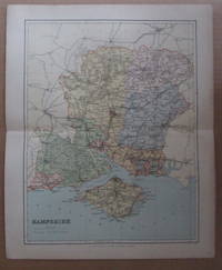
MAP OF HAMPSHIRE - 1894
de J.H.F. Brabner
- Usado
- very good
- Tapa blanda
- Estado
- Usado - Very Good
- Encuadernación
- Paperback
- Cantidad disponible
- 1
- Librería
-
South Kelsey, Lincolnshire, United Kingdom
- Precio
-
EUR 4.73
Mostrar detalles
Descripción:
United Kingdom: William Mackenzie. This is the 1894 coloured maps of Hampshire taken from 'The comprehensive gazetteer of England and Wales' edited by J.H.F. Brabner, published in 1894. Each map measures 32 x 25 cms and has a centre fold . Very Good. Soft cover. 1894.
Precio
EUR 4.73

Map of Lancashire. North Part and South Part (2 Maps)
de J.H.F. Brabner
- Usado
- very good
- Tapa blanda
- Estado
- Usado - Very Good
- Encuadernación
- Paperback
- Cantidad disponible
- 1
- Librería
-
South Kelsey, Lincolnshire, United Kingdom
- Precio
-
EUR 7.10
Mostrar detalles
Descripción:
United Kingdom: William Mackenzie. These are two 1894 coloured maps of Lancashire (North and South) taken from 'The comprehensive gazetteer of England and Wales' edited by J.H.F. Brabner, published in 1894. Each map measures 32 x 25 cms and has a centre fold . Very Good. Soft cover. 1894.
Precio
EUR 7.10

Plan of Leeds 1894
de J.H.F. Brabner
- Usado
- very good
- Estado
- Usado - Very Good
- Cantidad disponible
- 1
- Librería
-
South Kelsey, Lincolnshire, United Kingdom
- Precio
-
EUR 10.65
Mostrar detalles
Descripción:
United Kingdom: William Mackenzie. This is a 1894 coloured map of Leeds taken from 'The comprehensive gazetteer of England and Wales' edited by J.H.F. Brabner published in 1894. The map measures 32 x 25 cms and has a centre fold. . Very Good. No Binding. 1894.
Precio
EUR 10.65

Plan of Leicester 1894
de J.H.F. Brabner
- Usado
- very good
- Estado
- Usado - Very Good
- Cantidad disponible
- 1
- Librería
-
South Kelsey, Lincolnshire, United Kingdom
- Precio
-
EUR 10.65
Mostrar detalles
Descripción:
United Kingdom: William Mackenzie. This is a 1894 coloured map of Leicester taken from 'The comprehensive gazetteer of England and Wales' edited by J.H.F. Brabner, published in 1894. The map measures 32 x 25 cms and has a centre fold. In very good condition with just a faint dust mark to bottom outer margin area. See image from Winghale Books. . Very Good. No Binding. 1894.
Precio
EUR 10.65

Plan of Hull 1894
de J.H.F. Brabner
- Usado
- very good
- Estado
- Usado - Very Good
- Cantidad disponible
- 1
- Librería
-
South Kelsey, Lincolnshire, United Kingdom
- Precio
-
EUR 10.65
Mostrar detalles
Descripción:
United Kingdom: William Mackenzie. This is a 1894 coloured map of Hull taken from 'The comprehensive gazetteer of England and Wales' edited by J.H.F. Brabner published in 1894. The map measures 32 x 25 cms and has a centre fold. . Very Good. No Binding. 1894.
Precio
EUR 10.65
