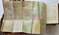
Descripción:
Paris: Jaillot, 1695. VG, with only flaw some dampstaining at lower margin with expert verso paper reinforcement, not affecting main image (would mat well). Centerfold as issued; hand-colored. A very uncommon and attractive plate, with a small walled city view (birds-eye) of Vienna, with all surrounding villages (castles) marked. A nice image of the Danube is central here. Jaillot was originally a sculptor (see Moreland & Bannister: Antique Maps). The copperplate image is 18x25.5 inches. .
A. E. S. Road Map U. S. Zone Germany 1947 (40-1/2 x 34 inch) de U. S. Army - 1947
de U. S. Army

A. E. S. Road Map U. S. Zone Germany 1947 (40-1/2 x 34 inch)
de U. S. Army
- Usado
- very good
- Tapa blanda
Engineer Base Plant, 1947 Map. Very Good. Loosely Bound Soft Cover. Rare two-sided U. S. Army map with additional information on the other side. (40-1/2 x 34 inch). Some corner creases otherwise very good..
-
Librería
Rose City Books
 (US)
(US)
- Formato/Encuadernación Tapa blanda
- Estado del libro Usado - Very Good
- Estado de la sobrecubierta No Jacket
- Encuadernación Tapa blanda
- Editorial Engineer Base Plant
- Fecha de publicación 1947

(Map / Chart- Environs of Vienna, Austria): Plan de la Ville De Vienne en Austriche et Ses Environs
de Jaillot, Alexis-Hubert
- Usado
- Estado
- Usado
- Encuadernación
- Unknown
- Cantidad disponible
- 1
- Librería
-
Crozet, Virginia, United States
- Precio
-
EUR 562.39
Mostrar detalles
Precio
EUR 562.39
Más fotos
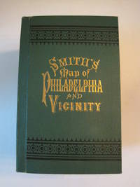
New Map of Philadelphia and Vicinity Published by J. L. Smith, 27 South Sixth St., Philadelphia, 1894 : [Cover title: Smith's Map of Philadelphia and Vicinity]
de Smith, J. L.
- Usado
- Tapa dura
- First
- Estado
- Usado - Fine condition
- Edición
- 1st ed? (No additional printings listed)
- Encuadernación
- Hardcover
- Cantidad disponible
- 1
- Librería
-
Henderson, Nevada, United States
- Precio
-
EUR 543.49
Mostrar detalles
Descripción:
Philadelphia: J. L. Smith, 1894. Fine condition. SEE PHOTOS. A very attractive, well preserved copy of this detailed two-part map of Philadelphia and vicinity, published in 1894 (copyright 1893). Tough-to-find in collectible condition as nice as this. A bright, clean copy. NO chips. NO tears. NO creases. NO owner's name or bookplate. Clean and unmarked. Drawn on a scale of 1 inch to the mile. The map consists of two parts. The eastern half unfolds to 23" wide by 27" tall. The western part is 21.5" wide by 27" tall. Both are skillfully and attractively hand colored. The maps are backed in linen, as issued. They are housed in the publisher's original, green cloth portfolio, which is printed in black and embossed in gold on the front cover and in blind on the rear. Gilt lettering is still as bright and shiny as new.. 1st ed? (No additional printings listed). Hardcover. Fine condition.
Precio
EUR 543.49
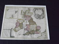
Les Isles Britanniques, qui Contiennent les Royaumes d' Angleterre, Escosse, et Irande…
de Valk, Gerard
- Usado
- Estado
- Usado
- Cantidad disponible
- 1
- Librería
-
Florham Park, New Jersey, United States
- Precio
-
EUR 567.12
Mostrar detalles
Descripción:
Copper engraved, double page, map, hand colored, cartouche uncolored, 49 x 59 cm (19 1/2" x 23"). Some minor soiling and aging; otherwise very good and quite colorful. Valk (1651-1726) was born in Amsterdam, and was also known as Valck. He was a fairly well known engraver and publisher, and would eventually go into partnership with Peter Schenk (1655-1718), and would produce an atlas and maps together. In fact, it seems they brought the property of the Blaeu firm, which gave them material for their maps. This is a very attractive map of Britain, and includes an inset of Orkney, Shetland and Faro islands. The map also contains a large cartouche that depicts angels and Poseidon. Bagrow p. 276.
Precio
EUR 567.12
Más fotos
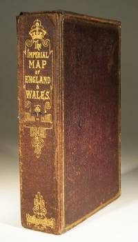
The Imperial Map of England and Wales
- Usado
- very good
- Tapa blanda
- Estado
- Usado - Very Good
- Encuadernación
- Paperback
- Cantidad disponible
- 1
- Librería
-
Farningham, Kent, United Kingdom
- Precio
-
EUR 496.61
Mostrar detalles
Descripción:
London & Edinburgh: A Fullarton & Co The Imperial Map of England and Wales according to the Ordnance Survey, with the latest additions shewing clearly every feature of the country, Railways and their Stations, Roads, Canals, Rivers, Gentlemens Seats etc. on the scale of 4 miles to an inch by John Bartholomew. 19 linen backed sheets numbered 1-15 plus 16 A,B and C. together with a folded index sheet. Flat sheet size, 550x750mm, folded size 275x185mm. All the maps in first class condition with no distress to folds. The folds to the paper index sheet have at some time been rather crudely stregthened. The whole enclosed in the original leathered covered box with an envelope style lid.
Precio
EUR 496.61

Más fotos
RAND MCNALLY & CO'S INDEXED COUNTY AND RAILROAD POCKET MAP AND SHIPPERS' GUIDE OF PENNSYLVANIA ACCOMPANIED BY.....COMPILATION AND READY REFERENCE INDEX SHOWING ENTIRE RAILROAD SYSTEM
de Rand McNally
- Usado
- very good
- Tapa dura
- First
- Estado
- Usado - Very Good
- Edición
- First Edition
- Encuadernación
- Hardcover
- Cantidad disponible
- 1
- Librería
-
Fairfield, New Jersey, United States
- Precio
-
EUR 425.34
Mostrar detalles
Descripción:
Chcago; New York: Rand McNally & Co.. Very Good. 1888. First Edition. Hardcover. Dark green boards with bright gilt title on front cover. Front endpaper has rand McNally ads: rear endpaper has map mounted onto it. Text is tight, clean & intact. Map measures 39" x 25 1/2" and is in very nice condition except for a few small tears on the folds. Pennsylvania, Map, Railroad. ; Fold out Map; 16mo 6" - 7" tall; 152 pages .
Precio
EUR 425.34

(Map of Pennsylvania): Geographical, Statistical, and Historical Map of Pennsylvania
de Carey & Lea (engr.by Young & Delleker)
- Usado
- Tapa dura
- First
- Estado
- Usado
- Encuadernación
- Hardcover
- Cantidad disponible
- 1
- Librería
-
Crozet, Virginia, United States
- Precio
-
EUR 378.08
Mostrar detalles
Descripción:
Philadelphia (Chestnut Street), 1822: HC Carey and I Lea, 1822. VG due to some minimal dampstaining most evident left upper corner, and minimally crossing neatline. The color portion of the map shows no significant visual effects from the stains. The original hand-colored image is clear and bright, with the surrounding letterpre ss text detailing aspects of population, climate, commerce, religion, government. There is a nice general historical sketch (in a separate page of original text, included here-- "Appendix to No. 18") in the letterpress. From the first edition "A Complete Historical, Chronological, and Geographical American Atlas...", which was also the first American atlas with letterpress printing on the map. This is a nice map, but for the defects described. The map image is 45x31cm; the entire image is 52.5x42cm..
Precio
EUR 378.08
Más fotos
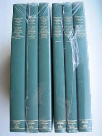
Mapping the Transmississippi West [1995, 6 separate vols, complete; with large FOLD-OUT maps; new, in publisher's shrinkwrap & PUBLISHER'S CARDBOARD SHIPPING BOX
de Wheat, Carl I.
- Nuevo
- Tapa dura
- First
- Estado
- New
- Estado de la sobrecubierta
- in publisher's shrinkwrap
- Edición
- First Martino/About Books printing
- Encuadernación
- Hardcover
- Cantidad disponible
- 1
- Librería
-
Henderson, Nevada, United States
- Precio
-
EUR 612.02
Mostrar detalles
Descripción:
Storrs-Mansfield, CT / Parsippany, New Jersey: Martino Fine Books / About Books, 1995. 6 separate volumes, complete [5 volumes bound in 6 books WITH LARGE FOLD-OUT MAPS -- just like the first edition]. SEE PHOTOS. Each of the 6 books in this 1995 large format edition measures 9.25" wide by 12.25" tall. [This is NOT the later, smaller format 3-volume reprint in which the maps are reduced in size]. Unlike later reduced-size editions, the maps in this 1995 six-volume edition measure as large as 21" by 33" when unfolded. SEE PHOTOS. As original co-publisher, we are pleased to offer the few remaining sets of the 1995 large-format 6-volume edition (recently rediscovered in our warehouse). They are BRAND NEW in perfect condition. STILL SEALED in the publisher's clear plastic SHRINKWRAP and the PUBLISHER'S CARDBOARD SHIPPING BOX. NO rubbing. NO fading. Bright, clean, square and tight. NO owner's name or bookplate. NOT a remainder. Fresh and crisp -- obviously…
Leer más Precio
EUR 612.02
Más fotos
An Epitome of General Ecclesiastical History, from the Earliest Period to the Present Time. With an Appendix, Giving a Condensed History of the Jews
de Marsh, Rev. John
- Usado
- Tapa dura
- Estado
- Usado - Very Good Minus
- Edición
- Eighth Edition
- Encuadernación
- Hardcover
- Cantidad disponible
- 1
- Librería
-
Bloomington, Indiana, United States
- Precio
-
EUR 567.12
Mostrar detalles
Descripción:
New York: J. Tilden and Co., 1844. SCARCE with both folding maps at front and folding chart present and in Very Good condition. Bound in contemporary full calf, gilt back, marbled edges. Very Good Minus, boards rubbed, hinges starting yet holding well, 1/8" loss of calf at head of spine, moderate toning throughout, prior owner name in ink. Large map at front hand colored, small tears and creases, light toning, 2nd map with 1 small tear, light toning, folding chart at rear with chip to fore edge margin, light toning and creasing. 462 pages, illustrated title page with portrait frontis, followed by 6 engraved plates. . Eighth Edition. Calf. Very Good Minus. 8vo - over 7¾" - 9¾" tall.
Precio
EUR 567.12

Más fotos
Atlas to Accompany Monograph XXXII on the Geology of the Yellowstone National Park
de Hague, Arnold
- Usado
- good
- Tapa dura
- Estado
- Usado - Good
- Encuadernación
- Hardcover
- Cantidad disponible
- 1
- Librería
-
Lansdowne, Pennsylvania, United States
- Precio
-
EUR 414.00
Mostrar detalles
Descripción:
Washington, D.C.: United States Geological Survey, 1904. Hardcover. Good. 34 leaves: 24 color maps (7 double-leaf); 56 cm. Dark brown cloth with gilt-stamped cover title. Monographs of the United States Geological Survey, v. 32. In Good Condition: cloth is soiled and rubbed; corners are frayed; minor loss at ends of spine; blank leaf preceding title page is torn from fore-edge to gutter; faint dampstain along fore-edges and lower corners throughout, not impacting maps; closed 2-cm. tear from fore-edge of 2 maps; otherwise, clean and tight.
Precio
EUR 414.00

Más fotos
A star atlas for the library, the school, and the observatory showing 6,000 stars and 1,500 objects of interest
de PROCTOR, Richard A
- Usado
- near fine
- Tapa dura
- Estado
- Usado - Near Fine
- Encuadernación
- Hardcover
- Cantidad disponible
- 1
- Librería
-
COLUMBIA, Missouri, United States
- Precio
-
EUR 566.17
Mostrar detalles
Descripción:
1874 Astronomy Star ATLAS Zodiac Constellation MAPS Richard Proctor AstrologyRichard Proctor was a 19th-century English astronomer known for his studies on the planets in the solar system as well as the moon and the sun. In his many astronomical books, Proctor discusses his research on the planets, stars and constellations, and the sun, as well as his observations on meteors and comets. His most fascinating work was 'A Star Atlas' – an impressive collection of star and constellation charts and night sky maps.
Item number: #19450
Price: $599
PROCTOR, Richard A
A star atlas for the library, the school, and the observatory showing 6,000 stars and 1,500 objects of interest
London : Longmans, Green, 1874.
Details:
· Collation: Complete with all pages
o
14, [2]
o
14 double-page charts
· Language: English
· Binding: Hardcover; tight and secure
o
Cloth
· Size: ~14.75in X 9.75in (37.5cm x 25cm)
· Quite scarce
Our Guarantee:
Very Fast. Very Safe. Free Shipping… Leer más
Precio
EUR 566.17

The Growing Complexity of Sino-Indian Ties
de Pant Ph.D., Dr. Harsh V.; Strategic Studies Institute (U.S.) [Editor]; Lovelace Jr., Douglas C. [Foreword]; Army War College (U.S.) [Producer];
- Usado
- Tapa blanda
- Estado
- Used: Good
- Encuadernación
- Paperback
- ISBN 10 / ISBN 13
- 9781584876304 / 1584876301
- Cantidad disponible
- 1
- Librería
-
HOUSTON, Texas, United States
- Precio
-
EUR 3.97
Mostrar detalles
Descripción:
Department of the Army, 2015-06-29. Paperback. Used: Good.
Precio
EUR 3.97
The Growing Complexity of Sino-Indian Ties
de Pant Ph.D., Dr. Harsh V.; Strategic Studies Institute (U.S.) [Editor]; Lovelace Jr., Douglas C. [Foreword]; Army War College (U.S.) [Producer];
- Usado
- Tapa blanda
- Estado
- Used:Good
- Encuadernación
- Paperback
- ISBN 10 / ISBN 13
- 9781584876304 / 1584876301
- Cantidad disponible
- 1
- Librería
-
HOUSTON, Texas, United States
- Precio
-
EUR 3.97
Mostrar detalles
Descripción:
Department of the Army, 2015-06-29. Paperback. Used:Good.
Precio
EUR 3.97
U S Army Survival Manual: FM 21-76
de U.S. Department of the Army
- Usado
- Estado
- UsedGood
- ISBN 10 / ISBN 13
- 9780760723142 / 0760723141
- Cantidad disponible
- 1
- Librería
-
Imperial, Missouri, United States
- Precio
-
EUR 4.17
Mostrar detalles
Descripción:
UsedGood. The item shows wear from consistent use, but it remains in good condition and works perfectly. All pages and cover are intact (including the dust cover, if applicable). Spine may show signs of wear. Pages may include limited notes and highlighting. May NOT include discs, access code or other supplemental materials.
Precio
EUR 4.17

Foto de archivo: la portada puede ser diferente
Back to Serve: Return of a Soldier
de U.S. Army (Ret.), CW3 Cesare Giannetti
- Usado
- Tapa blanda
- Estado
- Like New
- Encuadernación
- Paperback
- ISBN 10 / ISBN 13
- 9781981653287 / 1981653287
- Cantidad disponible
- 2
- Librería
-
Chicago, Illinois, United States
- Precio
-
EUR 1.57
Mostrar detalles
Descripción:
CreateSpace Independent Publishi, 2018-05-02. Paperback. Like New. 0.5300 in x 8.5000 in x 5.5000 in.
Precio
EUR 1.57

Foto de archivo: la portada puede ser diferente
Survival : How Being Prepared Can Keep You and Your Family Safe
de Honoré (U.S. Army, Lt. Russel
- Usado
- Estado
- Used - Very Good
- ISBN 10 / ISBN 13
- 9781416599012 / 1416599010
- Cantidad disponible
- 1
- Librería
-
Mishawaka, Indiana, United States
- Precio
-
EUR 4.73
Mostrar detalles
Descripción:
Atria Books. Used - Very Good. Used book that is in excellent condition. May show signs of wear or have minor defects.
Precio
EUR 4.73

Foto de archivo: la portada puede ser diferente
Quality Assurance Representative's Guide: General Information and Sitework: Vol 1
de Department of Army: U.S. Army Corps of E (Creator)
- Usado
- good
- Tapa blanda
- Estado
- Usado - Good
- Encuadernación
- Paperback
- ISBN 10 / ISBN 13
- 9781288776399 / 128877639X
- Cantidad disponible
- 1
- Librería
-
HOUSTON, Texas, United States
- Precio
-
EUR 4.80
Mostrar detalles
Descripción:
BiblioGov, 2013-02-14. Paperback. Good.
Precio
EUR 4.80

Foto de archivo: la portada puede ser diferente
ROTARY WING FLIGHT TM 1-260
de U.S. DEPARTMENT OF ARMY (Creator)
- Usado
- good
- Tapa blanda
- Estado
- Usado - Good
- Encuadernación
- Paperback
- ISBN 10 / ISBN 13
- 9781245565448 / 1245565443
- Cantidad disponible
- 1
- Librería
-
HOUSTON, Texas, United States
- Precio
-
EUR 4.87
Mostrar detalles
Descripción:
Nabu Press, 2011-09-15. Paperback. Good.
Precio
EUR 4.87
De facto Pathfinder
de U.S. Army (Ret.), CW3 Cesare Giannetti
- Usado
- good
- Estado
- Usado - Good
- ISBN 10 / ISBN 13
- 9781726868921 / 1726868923
- Cantidad disponible
- 1
- Librería
-
Philadelphia, Pennsylvania, United States
- Precio
-
EUR 4.87
Mostrar detalles
Descripción:
Independently published. Good. Good. Ship within 24hrs. Satisfaction 100% guaranteed. APO/FPO addresses supported
Precio
EUR 4.87

Foto de archivo: la portada puede ser diferente
Operational Lessons Learned in the Korean War
de U.S. Army Command and General Staff College
- Usado
- Tapa blanda
- Estado
- Used:Good
- Encuadernación
- Paperback
- ISBN 10 / ISBN 13
- 9781500798192 / 1500798193
- Cantidad disponible
- 1
- Librería
-
HOUSTON, Texas, United States
- Precio
-
EUR 4.92
Mostrar detalles
Descripción:
CreateSpace Independent Publishing Platform, 2014-08-11. Paperback. Used:Good.
Precio
EUR 4.92
Introduction to Leadership, MSL I, Revised Edition (BOLC I: Army ROTC)
de U. S. Army
- Usado
- good
- Tapa blanda
- Estado
- Usado - Good
- Encuadernación
- Paperback
- ISBN 10 / ISBN 13
- 9780536563170 / 0536563179
- Cantidad disponible
- 1
- Librería
-
Houston, Texas, United States
- Precio
-
EUR 4.93
Mostrar detalles
Descripción:
Pearson Custom, 2009-01-01. paperback. Good. 8x5x0.
Precio
EUR 4.93

Más fotos
The Sky and the Forest
de Forester, C.S
- Usado
- very good
- Tapa dura
- First
- Estado
- Usado - Very Good
- Estado de la sobrecubierta
- Very Good
- Edición
- First Edition
- Encuadernación
- Hardcover
- Cantidad disponible
- 1
- Librería
-
Salem, Oregon, United States
- Precio
-
EUR 32.98EUR 19.78¡Ahorra EUR 13.96!
Mostrar detalles
Descripción:
C.S. Forester: The Sky and the Forest. Little, Brown and Company, Boston. Stated First Edition First Printing Thus August, 1948. Cover price $2.75. Used. VG BOOK/VG UNCLIPPED DUST JACKET. A story of a central Africa. By C.S. Forester, author of the Admiral Hornblower series.
Precio
EUR 32.98EUR 19.78
¡Ahorra EUR 13.96
!
![Alaska and Klondike Region; [With inset of Klondike Region on the Upper Yukon detail] [From an...](https://d3525k1ryd2155.cloudfront.net/h/062/537/1339537062.0.m.jpg)
Alaska and Klondike Region; [With inset of Klondike Region on the Upper Yukon detail] [From an atlas, "Gazetteer of Alaska and Yukon Region " pp. 105 and 106]
de Miller, J. Martin
- Usado
- very good
- Estado
- Usado - Very Good
- Edición
- Unknown
- Cantidad disponible
- 1
- Librería
-
Sebastopol, California, United States
- Precio
-
EUR 36.86
Mostrar detalles
Descripción:
Chicago: J. Martin Miller, 1899. Unknown. Map. Very Good. [Map copyright 1899, printing date of Atlas later] [19.875x15.125in]; Colored map of Alaska with steamer routes from Portland and Seattle, insets of the Klondike Region on the Upper Yukon and Western portion of Aleutian Islands; On verso index of places and names with two large black and white images; Age toning to all edges, water stain marks on bottom, slight printing offset of colors, small chips and closed tears to lower edge;.
Precio
EUR 36.86

Zemepis Sveta - Monsunova Asie
de De La Blache, P. Vidal; Gallois, L
- Usado
- Tapa dura
- Estado
- Usado - Very Good Condition
- Estado de la sobrecubierta
- No Dust Jacket
- Encuadernación
- Hardcover
- Cantidad disponible
- 1
- Librería
-
Oak Point, Texas, United States
- Precio
-
EUR 56.71
Mostrar detalles
Descripción:
Aventinum, Prague, Czechoslovakia, 1931. Hardcover. Very Good Condition/No Dust Jacket. Text entirely in Czech. Geography book on Asia with numerous photographs and maps. 1930 edition also available. Size: 4mo - over 9 3/4" - 12" tall. 400 pp. Pages are yellowed, but are tight and clean. Moderate shelfwear along the spine. Corners are lightly bumped. Quantity Available: 1. Shipped Weight: 3-5 pounds. Category: Travel & Places; Non-English Language::Czech; Pictures of this item not already displayed here available upon request. Inventory No: 001228. . Additional shipping charges may apply.
Precio
EUR 56.71

Zemepis Sveta - Monsunova Asie
de De La Blache, P. Vidal; Gallois, L
- Usado
- Tapa dura
- Estado
- Usado - Very Good Condition
- Estado de la sobrecubierta
- No Dust Jacket
- Encuadernación
- Hardcover
- Cantidad disponible
- 1
- Librería
-
Oak Point, Texas, United States
- Precio
-
EUR 56.71
Mostrar detalles
Descripción:
Aventinum, Prague, Czechoslovakia, 1930. Hardcover. Very Good Condition/No Dust Jacket. Text entirely in Czech. Geography book on Asia with numerous photographs and maps. 1931 edition also available. Size: 4mo - over 9 3/4" - 12" tall. 400 pp. Pages are yellowed, but are tight and clean. Moderate shelfwear along the spine. Corners are lightly bumped. Quantity Available: 1. Shipped Weight: 3-5 pounds. Category: Travel & Places; Non-English Language::Czech; Pictures of this item not already displayed here available upon request. Inventory No: 001227. . Additional shipping charges may apply.
Precio
EUR 56.71

North America from the Best Authorities, Russell, ca.1800
de Russell
- Usado
- Estado
- Usado
- Cantidad disponible
- 1
- Librería
-
Plymouth, Devon, United Kingdom
- Precio
-
EUR 23.65
Mostrar detalles
Descripción:
Russell, J. : A General Map of North America from the Best Authorities. Nd but ca.1800. From "A New Geographical, Historical and Commercial Grammar and Present State of Several Kingdoms of the World." Copper engraving. Size approx 200 x 230mm. Two neat folds. Some age colouring to edges, otherwise very clean and bright.
Precio
EUR 23.65

Asia from the Best Authorities, Russell, ca.1800
de Russell
- Usado
- Estado
- Usado
- Cantidad disponible
- 1
- Librería
-
Plymouth, Devon, United Kingdom
- Precio
-
EUR 23.65
Mostrar detalles
Descripción:
Russell, J. : Asia from the Best Authorities. Nd but ca.1800. From "A New Geographical, Historical and Commercial Grammar and Present State of Several Kingdoms of the World". Copper engraving. Size approx 200 x 230mm. Two neat folds. Some age colouring to edges, otherwise clean and bright. Includes Arabia, India, Borneo, Japan, China and eastern Russia.
Precio
EUR 23.65
![MAP OF UTAH [Territory]](https://d3525k1ryd2155.cloudfront.net/h/836/461/1485461836.0.m.jpg)
Más fotos
MAP OF UTAH [Territory]
- Usado
- Estado
- Usado - Very Good-
- Edición
- Original
- Cantidad disponible
- 1
- Librería
-
Williamsburg, Virginia, United States
- Precio
-
EUR 61.44
Mostrar detalles
Descripción:
New York, Richmond, Chicago, & Toledo: H. H. Hardesty, 1885. Original color lithographed map printed by Rand, McNally & Company, Engravers and published in HARDESTY'S HISTORICAL AND GEOGRAPHICAL ENCYCLOPEDIA: SPECIAL VIRGINIA EDITION. 19 3/8 inches by 13 1/4 inches on a 21" X 14 1/2" sheet. The map depicts the Territory of Utah in its final form--large areas had been removed and ceded to Nevada, Colorado, Wyoming, and Nebraska since Utah became a U. S. Territory in 1850. The issue of polygamy prevented statehood until it was finally granted in 1896. This map features railroads and topography and uses color to set off counties from each other. Unlike most atlas maps of the period, this map identifies most small towns. The map is guaranteed to be moe than 135 years old. The map is in about very good condition: generally clean and bright, with slight toning of paper and one faint water stain near the center-left edge of the map.. Original. Single Sheet. Very Good-. Elephant…
Leer más Precio
EUR 61.44

Philips Special Map of the Nile, The Advance on Khartum and the Environs of Omdurman. Cc1900
de George Philips and Son,
- Usado
- Estado
- Usado
- Cantidad disponible
- 1
- Librería
-
Plymouth, Devon, United Kingdom
- Precio
-
EUR 30.74
Mostrar detalles
Descripción:
Philips Special map of the Nile illustrating the Advance on Khartum [Khartoum] with an enlargement of the environs of Omdurman [Omdur]. George Philips and Son, London and Liverpool Ca 1900. 580mm x 900mm folded map. Front title wrapper has come loose, not affecting map area. Three maps are displayed within the sheet. Map1. Map of the Nile Valley 520mm x 300mm showing the approaches of Khartum. Scale 1inch to 100 Geographical miles. Coloured indicating Possessions and Protectorates of European Powers. Map 2. Special map of the Nile from Dongola to Khartum. Scale 16 miles to the inch. Coloured. In set in this map is Map3. Environs of Omdurman, Scale 5 statute miles to the inch. Some small breaks at some folds, not affecting imagery or use of map. Title label is damaged, the map is clean and bright, probably unused. A very interesting record.
Precio
EUR 30.74

Last Tales
de Dinesen, Isak
- Usado
- very good
- Tapa dura
- First
- Estado
- Usado - Very Good
- Estado de la sobrecubierta
- Good+
- Edición
- First Edition
- Encuadernación
- Hardcover
- Cantidad disponible
- 1
- Librería
-
Salem, Oregon, United States
- Precio
-
EUR 113.42EUR 68.05¡Ahorra EUR 48.00!
Mostrar detalles
Descripción:
Dinesen, Isak: Last Tales, A Collection of Twelve New Tales of Compelling Beauty 1957, Random House. First Edition. Stated First Printing Thus. Used. Very Good/Good+ original red dust jacket, price-clipped. Jacket states 11/57 on front flap. 5 3/4 X
Precio
EUR 113.42EUR 68.05
¡Ahorra EUR 48.00
!

The Adventure of Wrangel Island
de Vilhjalmur Stefansson
- Usado
- good
- Tapa dura
- First
- Estado
- Usado - Good
- Estado de la sobrecubierta
- No DJ Included
- Edición
- First Edition
- Encuadernación
- Hardcover
- Cantidad disponible
- 1
- Librería
-
Salem, Oregon, United States
- Precio
-
EUR 118.05EUR 70.82¡Ahorra EUR 49.96!
Mostrar detalles
Descripción:
The Adventure of Wrangel Island, Alaska (1925 Macmillan 1st Edition) HISTORY OF ALASKA. EXLIB. Good Condition/ No DJ included. Fold-out map affixed to binding at the back of the book has never been opened. The story of the (unsuccessful) attempted colonization of Wrangel Island Alaska. 413 pages plus appendix, Index. Titling is still bright. A clean, solid copy. Scarce.
Precio
EUR 118.05EUR 70.82
¡Ahorra EUR 49.96
!