
Ver a tamaño completo.
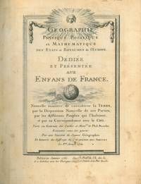
Géographie Physique Politique et Mathématique des Etats et royaumes de l'Europe. Dédiée et présentée aux enfans de France. Nouvelle manière de considérer la TERRE, par la Disposition Naturelle de ses Parties, par les différents Peuples qui l'habitent, et par sa Correspondance avec le Ciel. Tirée ou extraite des cartes et Mém.res de Phil. Buache. Exécutée sous ses yeux Par una Societé de Jeunes Géographes Et honorée du Suffrage de l'ACADEMIE DES SCIENCES Le P.er Aoust 1761.
de BUACHE Philippe -
- Usado
- Tapa dura
- Estado
- Ver descripción
- Librería
-
MONTE SAN PIETRO, Bologna, Italy
Formas de pago aceptadas
Sobre este artículo
(Paris), Publiée sous le privilège de l'Académie des Sciences... , 1762. Two parts in one quarto volume (cm. 25 x 19), nineteenth-century quarter leather binding, five-ribs spine with golden lettering. The first part of this work relates to political geography, and contains 20 copper plates: illustrated title-page, table of the maps, 5 other tables with reading instructions, and 13 geographical maps: Map of the World, Map of Europe, Kingdom of Spain and Portugal, Kingdom of France, Italy, Germany, Turkey, Poland and Prussia, Russian Empire, Northern European Russia, Kingdom of Sweden and Denmark together with Norway and Iceland, Great Britain, and a map of French Universities. All of these maps are double-page plates, except for the one representing Scandinavia, which is a folding map, and except for the title-page and the table of the maps, which are single-page plates. The second part of this work relates to physical geography and is composed by 16 copper plates: illustrated title-page, physical Map of the world, astronomical map, folding table of the climatic zones of the world, table of the maps, Europe, Kingdom of Spain and Portugal, Kingdom of France, Italy, Germany, Turkey, Poland and Prussia, Russian Empire, Northern European Russia, Kingdom of Sweden and Denmark together with Norway and Iceland (folding map), Great Britain. In this case as well, all the plates are double-page, except for the table, which is a single-page plate, and the folding maps.
All the plates of this volume, except for the two title-pages, are hand colored.
Contemporary ex libris (Stephani Gaillard) pasted on the first end-paper. Small tears and erasures at the spine and the covers. Otherwise, a well-preserved volume. Rare and wonderful. =========== [Paris], Publiée sous le privilège de l'Académie des Sciences... , 1762. Due parti rilegate in un volume in-4° (cm. 25 x 19) in mezza pelle ottocentesca, dorso a cinque nervi con titoli in oro su doppio tassello, tagli rossi. La prima parte, relativa alla geografia politica, contiene venti tavole calcografiche: frontespizio illustrato, indice dell'ordine della carte, cinque tabelle a doppia pagina con indicazioni per la lettura delle tavole, e tredici carte geografiche: Mappamondo, Carta dell'Europa, Regno di Spagna e Portogallo, Regno di Francia, Italia, Germania, Turchia, Polonia e Prussia, Impero Russo, Russia Europea settentrionale, Regno di Svezia e Danimarca con unita la Norvegia e l'Islanda (ripiegata), Gran Bretagna, Università di Francia. Tutte e venti le tavole sono a doppia pagina, ad eccezione della carta della Scandinavia, che è ripiegata, e del frontespizio e dell'indice, che sono a pagina singola. La seconda parte, relativa alla geografia fisica, è composta da sedici tavole incise in rame: frontespizio, mappamondo fisico, mappamondo astronomico, tavola delle zone climatiche terrestri (ripiegata), indice dell'ordine delle carte, Europa, Regno di Spagna e Portogallo, Regno di Francia, Italia, Germania, Turchia, Polonia e Prussia, Impero Russo, Russia Europea settentrionale, Regno di Svezia e Danimarca con unita la Norvegia e l'Islanda (ripiegata), Gran Bretagna. Anche in questo caso, ad eccezione dell'indice e delle carte ripiegate, le tavole sono a doppia pagina. Tutte le incisioni del volume, tranne i frontespizi, sono colorate a mano. Prima edizione di uno dei più apprezzati atlanti settecenteschi dedicati alla Europa, in cui il celebre geografo francese Philippe Bauche de Neuville (1700-1773) presenta un'efficace sintesi tra geografia fisica, geografia astronomica o matematica, e geografia politica. Nel 1729 Buache fu nominato Premier Géographe du Roi, incarico che mantenne fino alla morte nel 1773. Membro della prestigiosa Académie des Sciences parigina, molte sono le opere che diede alle stampe, spesso realizzate in collaborazione con alcuni dei suoi più valenti allievi. Questo è il caso dell'atlante dell'Europa qui presentato, realizzato sotto la sua attenta guida da un gruppo di giovani discepoli, indicati al frontespizio come 'Société de Jeunes Géographes', e tra cui spicca François-Simon Mentelle (1732-1799), di cui sono note le osservazioni astronomiche condotte nella Guyana francese. Nel Journal des Savants del giugno 1762 apparve una recensione entusiastica della Géographie physique politique et mathématique, di cui si loda non solo la novità dell'approccio metodologico, ma anche l'accuratezza delle tavole e la loro coloritura. Profonda fenditura alla cerniera anteriore; difetti alle cuffie; angoli e bordi consunti; piccole abrasioni ai piatti; internamente, carta leggermente brunita, ma ottimo stato di conservazione. Ex libris nobiliare d'epoca (Stephani Gaillard) al contropiatto anteriore. Esemplare completo di quest'opera rara e bella in edizione originale.
Reseñas
(¡Iniciar sesión or Crear una cuenta primero!)
Detalles
- Librería
- Libreria Piani snc
 (IT)
(IT)
- Inventario del vendedor #
- 2-74134
- Título
- Géographie Physique Politique et Mathématique des Etats et royaumes de l'Europe. Dédiée et présentée aux enfans de France. Nouvelle manière de considérer la TERRE, par la Disposition Naturelle de ses Parties, par les différents Peuples qui l'habitent, et par sa Correspondance avec le Ciel. Tirée ou extraite des cartes et Mém.res de Phil. Buache. Exécutée sous ses yeux Par una Societé de Jeunes Géographes Et honorée du Suffrage de l'ACADEMIE DES SCIENCES Le P.er Aoust 1761.
- Autor
- BUACHE Philippe -
- Estado del libro
- Usado
- Encuadernación
- Tapa dura
Términos de venta
Libreria Piani snc
No problem with returns within 15 days of receipt
Sobre el vendedor
Libreria Piani snc
Miembro de Biblio desde 2007
MONTE SAN PIETRO, Bologna
Sobre Libreria Piani snc
We sell books on Natural History, science, literature, history, travel, mountain, ecc. ecc.
Glosario
Algunos términos que podrían usarse en esta descripción incluyen:
- Erasures
- Erasures indicates marks where someone has removed bits of text or content from a book. In Book Arts, erasures can also mean a...
- Plate
- Full page illustration or photograph. Plates are printed separately from the text of the book, and bound in at production. I.e.,...
- Spine
- The outer portion of a book which covers the actual binding. The spine usually faces outward when a book is placed on a shelf....
- Quarto
- The term quarto is used to describe a page or book size. A printed sheet is made with four pages of text on each side, and the...
