Descripción:
Lioncrest Publishing, 5/2/2019 12:00:01 AM. paperback. Very Good. 0.5000 in x 8.4000 in x 5.4000 in. Crease on cover and a few pages*
Île de New-York, partie de Long-Island ou de l'Île Longue et positions des armées américaine et britannique après le combat livré sur les hauteurs, le 27 Août, 1776. Revolutionary War map de Marshall, John - 1807
de Marshall, John
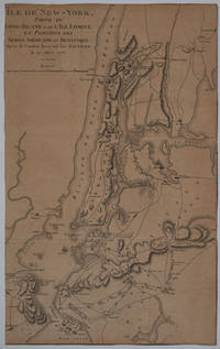
Île de New-York, partie de Long-Island ou de l'Île Longue et positions des armées américaine et britannique après le combat livré sur les hauteurs, le 27 Août, 1776. Revolutionary War map
de Marshall, John
- Usado
Paris: Dentu, 1807. Good + condition. Copper engraved map from John Marshall's 'Vie de George Washington', a fascinating record of British and American Revolutionary War battles in New York and Long Island.
Showing the New York and Long Island region from Fort Independence on the Hudson down to the Bay of New York and Gravesend; and from Oyster Bay in the west to "Flatland" showing the position of Lord Cornwallis in the east.
Also indicated are the locations of ships, armies, names of commanders, troop movements and positions, as well as dates, towns, rivers and forts.
Trimmed to inside the border, somewhat toned. 9 3/4 x 15 3/4"
-
Librería
Antipodean Books, Maps & Prints
 (US)
(US)
- Estado del libro Usado - Good + condition
- Cantidad disponible 1
- Editorial Dentu
- Lugar de publicación Paris
- Fecha de publicación 1807

Foto de archivo: la portada puede ser diferente
Your Next Adventure: Planning for Life After the Sale of Your Business
de Rowe, Marshall,Fitts, Jim,Weeks, John
- Usado
- very good
- Tapa blanda
- Estado
- Usado - Very Good
- Encuadernación
- Paperback
- ISBN 10 / ISBN 13
- 9781544502144 / 1544502141
- Cantidad disponible
- 1
- Librería
-
HILLSIDE, New Jersey, United States
- Precio
-
EUR 1.42
Mostrar detalles
Precio
EUR 1.42
Foto de archivo: la portada puede ser diferente
Your Next Adventure: Planning for Life After the Sale of Your Business
de Rowe, Marshall,Fitts, Jim,Weeks, John
- Usado
- good
- Tapa blanda
- Estado
- Usado - Good
- Encuadernación
- Paperback
- ISBN 10 / ISBN 13
- 9781544502144 / 1544502141
- Cantidad disponible
- 2
- Librería
-
HILLSIDE, New Jersey, United States
- Precio
-
EUR 1.42
Mostrar detalles
Descripción:
Lioncrest Publishing, 5/2/2019 12:00:01 AM. paperback. Good. 0.5000 in x 8.4000 in x 5.4000 in. Crease on cover and a few pages*
Precio
EUR 1.42

Foto de archivo: la portada puede ser diferente
Wide-Open World: How Volunteering Around the Globe Changed One Family's Lives Forever
de Marshall, John
- Usado
- Estado
- UsedGood
- ISBN 10 / ISBN 13
- 9780345549648 / 0345549643
- Cantidad disponible
- 1
- Librería
-
Imperial, Missouri, United States
- Precio
-
EUR 4.27
Mostrar detalles
Descripción:
UsedGood. The item shows wear from consistent use, but it remains in good condition and works perfectly. All pages and cover are intact (including the dust cover, if applicable). Spine may show signs of wear. Pages may include limited notes and highlighting. May NOT include discs, access code or other supplemental materials.
Precio
EUR 4.27

Have Your Bread and Eat It: The Complete Starch Blocker Weight Control Story
de Marshall, J. John; Lemon, J. Robert
- Usado
- Aceptable
- Tapa blanda
- Estado
- Usado - Fine
- Encuadernación
- Paperback
- Cantidad disponible
- 1
- Librería
-
Oxford, Michigan, United States
- Precio
-
EUR 1.10
Mostrar detalles
Descripción:
Unknown. PAPERBACK. B000HD9FSS Although the book is actually brand new, some mild accidental wear to the cover, keeps me from listing it as such. Otherwise, the book is still basically brand new. Ships, well packaged and very quickly, from MI. A detailed description is coming soon. The condition selected for the item is accurate and consistent with our other listings of the same general condition. If you have any questions or you would like a detailed description of the item prior to our revision of the listing, please do not hesitate to contact us. We will get back to you as quickly as possible. Please buy with confidence from us, as we have several thousand satisfied customers and your satisfaction is the goal we strive to achieve with every transaction. . Fine.
Precio
EUR 1.10

Foto de archivo: la portada puede ser diferente
The Doula Book: How a Trained Labor Companion Can Help You Have a Shorter, Easier, and Healthier Birth (A Merloyd Lawrence Book)
de Klaus, Marshall H., Kennell, John H., Klaus, Phyllis H
- Usado
- Estado
- Used - Good
- ISBN 10 / ISBN 13
- 9780738215068 / 0738215066
- Cantidad disponible
- 1
- Librería
-
Waltham, Massachusetts, United States
- Precio
-
EUR 1.83
Mostrar detalles
Descripción:
Da Capo Lifelong Books. Used - Good. A sound copy with only light wear. Overall a solid copy at a great price!
Precio
EUR 1.83

Foto de archivo: la portada puede ser diferente
Maternal-Infant Bonding : The Impact of Early Separation or Loss on Family Development
de Kennell, John H., Klaus, Marshall H
- Usado
- Estado
- Used - Good
- ISBN 10 / ISBN 13
- 9780801626302 / 0801626307
- Cantidad disponible
- 1
- Librería
-
Reno, Nevada, United States
- Precio
-
EUR 4.72
Mostrar detalles
Descripción:
Mosby. Used - Good. Used book that is in clean, average condition without any missing pages.
Precio
EUR 4.72

Foto de archivo: la portada puede ser diferente
Human Behavior in Global Perspective : An Introduction to Cross-Cultural Psychology
de Poortinga, Ype H., Dasen, Pierre R., Segall, Marshall H., Berry, John W
- Usado
- Estado
- Used - Good
- ISBN 10 / ISBN 13
- 9780080368139 / 0080368131
- Cantidad disponible
- 1
- Librería
-
Reno, Nevada, United States
- Precio
-
EUR 4.72
Mostrar detalles
Descripción:
PPI-UK. Used - Good. Used book that is in clean, average condition without any missing pages.
Precio
EUR 4.72

Foto de archivo: la portada puede ser diferente
The Life of George Washington
de MARSHALL, John
- Usado
- Estado
- Used - Good
- ISBN 10 / ISBN 13
- 9780865972773 / 086597277x
- Cantidad disponible
- 1
- Librería
-
Reno, Nevada, United States
- Precio
-
EUR 4.72
Mostrar detalles
Descripción:
Liberty Fund, Incorporated. Used - Good. Former library book; may include library markings. Used book that is in clean, average condition without any missing pages.
Precio
EUR 4.72
Foto de archivo: la portada puede ser diferente
Maternal-Infant Bonding : The Impact of Early Separation or Loss on Family Development
de Kennell, John H., Klaus, Marshall H
- Usado
- Estado
- Used - Good
- ISBN 10 / ISBN 13
- 9780801626302 / 0801626307
- Cantidad disponible
- 1
- Librería
-
Mishawaka, Indiana, United States
- Precio
-
EUR 4.72
Mostrar detalles
Descripción:
Mosby. Used - Good. Used book that is in clean, average condition without any missing pages.
Precio
EUR 4.72

Foto de archivo: la portada puede ser diferente
Accounting Information Systems
de Romney, Marshall B., Steinbart, Paul John
- Usado
- Estado
- Used - Good
- ISBN 10 / ISBN 13
- 9780136015185 / 0136015182
- Cantidad disponible
- 1
- Librería
-
Mishawaka, Indiana, United States
- Precio
-
EUR 4.82
Mostrar detalles
Descripción:
Pearson Education, Limited. Used - Good. Former library book; may include library markings. Used book that is in clean, average condition without any missing pages.
Precio
EUR 4.82