Descripción:
,CHRISTOPHER J. PAL", 9789351073895. 2020. Paperback. 9789351073895, DATA MINING : PRACTICAL MACHINE LEARNING TOOLS AND TECHNIQUES, 4TH EDITION , ELSEVIER INDIA
JEPPE'S MAP OF THE TRANSVAAL. SHEET NO. 3 (NORTH-EAST SECTION.) de (Jeppe, Frederick A.)
de (Jeppe, Frederick A.)
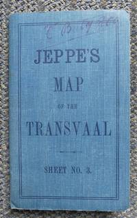
JEPPE'S MAP OF THE TRANSVAAL. SHEET NO. 3 (NORTH-EAST SECTION.)
de (Jeppe, Frederick A.)
- Usado
- very good
- Tapa blanda
London, (1899): Edward Stanford Folding linen map (42 sections), approximately 28" W x 39" H - folds down to approximately 4 1/4" W x 7" H when enclosed in blue cloth-covered card covers bearing title "Jeppe's Map of the Transvaal / Sheet No. 3. Map shows Lydenburg to the southwest and British Protectorate at northwest (bordered by the Limpopo River), Portuguese Territory at east and Uninspected Government Land at centre/east. Lithographed by Wurster, Randegger & Cie, Winterthur, Switzerland. Published by Edward Stanford, 26 & 27 Cockspur Street, Charing Gross (sic), S.W. On the front blue cover is written in ink "C" Bat'y R.C.A. and on the inside of the cover, in purple pencil, appears a group of initials with the rank "Major" and "C" Bat'y R.C.A. once again. ("C" Battery of the Royal Canadian Artillery landed in South Africa in 1900 and took part in the Relief of Mafeking.) A few tiny and small very light stains on back of map, map linen is in very good condition, previous owner's name in ink at top of fron cover, tiny bump at corners of covers, very small bump at top/bottom of spine, small notation and previous owner's name in pencil on inside of front cover, some soiling scuff marks on rear cover.. Unbound. Very Good.
-
Librería
Independent bookstores
 (CA)
(CA)
- Formato/Encuadernación Tapa blanda
- Estado del libro Usado - Very Good
- Encuadernación Tapa blanda
- Editorial Edward Stanford
- Lugar de publicación London, (1899)
- Palabras clave Transvaal, 19th Century, South Africa, Boer War, South African War, Lydenburg, Limpopo River, British Protectorate, Portuguese Territory, Africa, Victorian Era, Maps.

DATA MINING : PRACTICAL MACHINE LEARNING TOOLS AND TECHNIQUES, 4TH EDITION
de IAN H. WITTEN, EIBE FRANK & MARK A. HALL
- Usado
- Tapa blanda
- Estado
- Usado - Paperback
- Encuadernación
- Paperback
- Cantidad disponible
- 34
- Librería
-
New Delhi, India
- Precio
-
EUR 11,436.92
Mostrar detalles
Precio
EUR 11,436.92
WHEN IDEAS MATTER: DEMOCRACY AND CORRUPTION IN INDIA
- Usado
- Tapa dura
- Estado
- Usado - Hardcover
- Encuadernación
- Hardcover
- Cantidad disponible
- 40
- Librería
-
New Delhi, India
- Precio
-
EUR 11,436.92
Mostrar detalles
Descripción:
Bilal A. Baloch (", 9781316519837. 2021. Hardcover. 9781316519837, WHEN IDEAS MATTER: DEMOCRACY AND CORRUPTION IN INDIA , CAMBRIDGE INDIA
Precio
EUR 11,436.92
The Good Soldiers
de Moody, William B
- Usado
- very good
- Tapa dura
- Firmado
- First
- Estado
- Usado - Very Good
- Estado de la sobrecubierta
- Very Good
- Edición
- First Edition
- Encuadernación
- Hardcover
- ISBN 10 / ISBN 13
- 9780961649906 / 0961649909
- Cantidad disponible
- 1
- Librería
-
Southampton, New York, United States
- Precio
-
EUR 0.95
Mostrar detalles
Descripción:
Good Soldier Pub. First Edition. Hardcover. Very Good/Very Good. First Edition, First Printing. Published by Good Soldiers Publishing, 1986. Octavo. Green boards stamped in gold. Signed and inscribed by author on flyleaf. Book is very good; clean with no writing or names. Sharp corners and spine straight. Binding tight and pages crisp. Dust jacket is very good with light shelf wear with small tears on bottom front and back top edge. 130 pages. ISBN: 0961649909. 100% positive feedback. 30 day money back guarantee. NEXT DAY SHIPPING! Excellent customer service. Please email with any questions or if you would like a photo. All books packed carefully and ship with free delivery confirmation/tracking. All books come with free bookmarks. Ships from Southampton, New York.
Precio
EUR 0.95
HOTEL HOUSEKEEPING: OPERATIONS AND MANAGEMENT, 3RD EDN
- Usado
- Tapa blanda
- Estado
- Usado - Paperback
- Encuadernación
- Paperback
- Cantidad disponible
- 1
- Librería
-
New Delhi, India
- Precio
-
EUR 0.95
Mostrar detalles
Descripción:
G. Raghubalan ET AL", 9780199451746. 2015. Paperback. HOTEL HOUSEKEEPING: OPERATIONS AND MANAGEMENT, 3RD EDN ,
Precio
EUR 0.95
AD-HOC AND WIRELESS SENSOR NETWORK
- Usado
- Tapa blanda
- Estado
- Usado - Paperback
- Encuadernación
- Paperback
- Cantidad disponible
- 1
- Librería
-
New Delhi, India
- Precio
-
EUR 0.95
Mostrar detalles
Descripción:
SHASHIKANT V. ATHAWALE", 9789356066137. 2023. Paperback. AD-HOC AND WIRELESS SENSOR NETWORK ,
Precio
EUR 0.95
Greenhaven Press
- Usado
- Estado
- Usado - 3
- Cantidad disponible
- 1
- Librería
-
Philadelphia, Pennsylvania, United States
- Precio
-
EUR 0.95
Mostrar detalles
Descripción:
3.
Precio
EUR 0.95

Manning, Martha | Undercurrents | Unsigned First Edition Copy
de Manning, Martha
- Usado
- Aceptable
- Tapa dura
- First
- Estado
- Usado - Fine
- Encuadernación
- Hardcover
- Cantidad disponible
- 44
- Librería
-
Tualatin, Oregon, United States
- Precio
-
EUR 2.83EUR 1.13¡Ahorra EUR 1.79!
Mostrar detalles
Descripción:
HarperCollins, 1995. hardcover. Fine. First Edition Hardcover Book. November 1995 NY: HarperCollins First edition, first printing, fine in a fine dust jacket, remainder marked.
Precio
EUR 2.83EUR 1.13
¡Ahorra EUR 1.79
!

Foto de archivo: la portada puede ser diferente
The Federal Reserve Monster: Jack Holland Illustrated Edition
de Sam H Clark
- Usado
- good
- Tapa blanda
- Estado
- Usado - Good
- Edición
- Ill
- Encuadernación
- Paperback
- ISBN 10 / ISBN 13
- 9781461127536 / 146112753X
- Cantidad disponible
- 1
- Librería
-
HOUSTON, Texas, United States
- Precio
-
EUR 1.47
Mostrar detalles
Descripción:
CreateSpace Independent Publishing Platform, 2011-04-29. Ill. Paperback. Good.
Precio
EUR 1.47
