Ver a tamaño completo.
Jules A. Appler's Map of San Antonio, Tex., and Suburbs
de [Texas]. Appler, Jules A
- Usado
- Estado
- Very good.
- Librería
-
Dobbs Ferry, New York, United States
Formas de pago aceptadas
Sobre este artículo
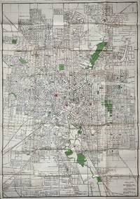
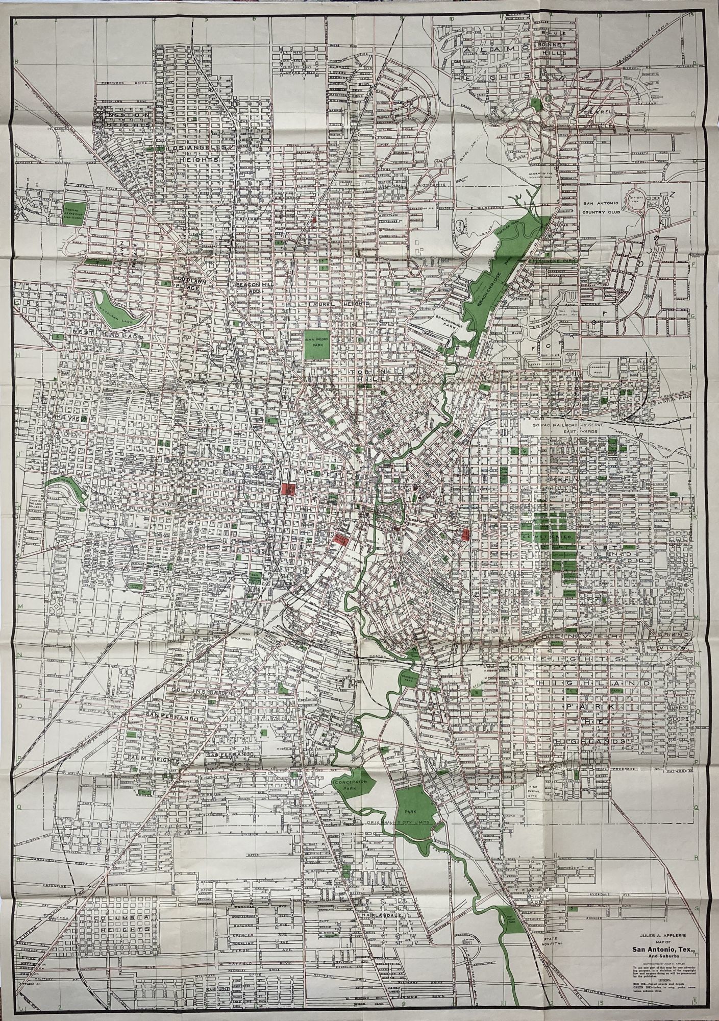
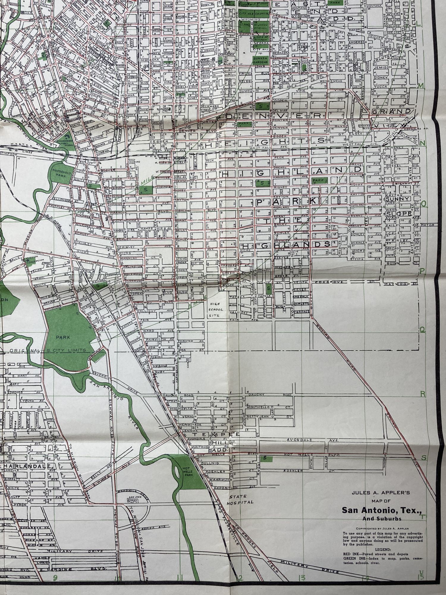
[San Antonio]: Jules A. Appler, 1940. Very good.. Large sheet map, 41.5 x 29.25 inches. Printed in black, green, and red. Old folds, some slight splitting at folds. Minor wear and soiling. A scarce, large-format map of San Antonio, Texas, capturing the city at the beginning of its World War II boom. This is perhaps the last work published by Jules A. Appler, a property developer who issued many of the city's most popular maps and directories over a 50-year period. Appler was active between 1890 and 1940, creating many of the most popular maps recording life in San Antonio over two generations of dramatic growth. This substantial map showcases all of San Antonio and its immediate environs. The city is shown centered upon the old town with its circular canal on the San Antonio River, with the Alamo nearby. Several railway lines converge on the center of the city, highlighting San Antonio's history as a transportation hub. The various named neighborhoods fan out in all directions, generally following a grid-pattern, interspersed by parklands, while the new suburbs, many with curvy street patterns, lie further afield.
Indicative of the city's diversity (and its contemporary racial segregation), the cemetery area, in the lower right center, notes the different sections for various Christian denomination, as well as ‘Hebrew' and ‘Colored' plots. While the map is undated, and the OCLC record simply says "1910s," it appears that Appler received a copyright for the map on August 20, 1940. Three institutional examples noted, at the Texas State Library, Southern Methodist University, and the Daughters of the Republic of Texas Library.
Indicative of the city's diversity (and its contemporary racial segregation), the cemetery area, in the lower right center, notes the different sections for various Christian denomination, as well as ‘Hebrew' and ‘Colored' plots. While the map is undated, and the OCLC record simply says "1910s," it appears that Appler received a copyright for the map on August 20, 1940. Three institutional examples noted, at the Texas State Library, Southern Methodist University, and the Daughters of the Republic of Texas Library.
Reseñas
(¡Iniciar sesión or Crear una cuenta primero!)
Detalles
- Librería
- McBride Rare Books
 (US)
(US)
- Inventario del vendedor #
- 2232
- Título
- Jules A. Appler's Map of San Antonio, Tex., and Suburbs
- Autor
- [Texas]. Appler, Jules A
- Estado del libro
- Usado - Very good.
- Cantidad disponible
- 1
- Editorial
- Jules A. Appler
- Lugar de publicación
- [San Antonio]
- Fecha de publicación
- 1940
Términos de venta
McBride Rare Books
All items are guaranteed as described. Any purchase may be returned for a full refund within 10 working days as long as it is returned in the same condition and is packed and shipped correctly. All items subject to prior sale.
Sobre el vendedor
McBride Rare Books
Miembro de Biblio desde 2018
Dobbs Ferry, New York
Sobre McBride Rare Books
We specialize in American history, focusing on unique and eclectic materials such as archives, broadsides, vernacular photography, and interesting or unusual imprints. Particular fields of interest include Western Americana and Latin America.
Glosario
Algunos términos que podrían usarse en esta descripción incluyen:
- New
- A new book is a book previously not circulated to a buyer. Although a new book is typically free of any faults or defects, "new"...