Ver a tamaño completo.
Karte Der Kurillischen Inseln nach der Russischen Karte Gezeichnet von Laurent.
de Bellin (Jacques-Nicolas) [Nicolaus] (Published by: Johann Joachim Schwabe)
- Usado
- Estado
- Ver descripción
- Librería
-
Sidney, British Columbia, Canada
Formas de pago aceptadas
Sobre este artículo
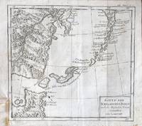
Leipzig: Arkstee und Merkus, c.1771. A copper engraved map on laid paper, uncoloured, from Volume 20 of Schwabe's Allgemeine Historie der Reisen (1748 - 1774). Image size is 26cm x 24cm. Text in German. Verso blank. In upper right corner: "XX. Band No. 15.". Original folds, very good condition, yellow tape or glue mark at lower left, on verso, light foxing to margins. A map of the Kuril Islands, from Bellin's French map (Carte des Iles Kouriles....) published in Prevost's L'Histoire Generale des Voyages (Volume 19, 1770). The contentious Kuril Islands lie between Japan and Russia, claimed by Russia after World War 2.
Reseñas
(¡Iniciar sesión or Crear una cuenta primero!)
Detalles
- Librería
- William Matthews, Bookseller / The Haunted Bookshop
 (CA)
(CA)
- Inventario del vendedor #
- 56073
- Título
- Karte Der Kurillischen Inseln nach der Russischen Karte Gezeichnet von Laurent.
- Autor
- Bellin (Jacques-Nicolas) [Nicolaus] (Published by: Johann Joachim Schwabe)
- Estado del libro
- Usado
- Cantidad disponible
- 1
- Editorial
- Leipzig: Arkstee und Merkus, c.1771
- Catálogos del vendedor
- Maps;
Términos de venta
William Matthews, Bookseller / The Haunted Bookshop
Prices are in US Dollars. Books are guaranteed to be as described. Books may be returned within a reasonable length of time. Paypal Payments are made to: bill@rainbownorth.com
Sobre el vendedor
William Matthews, Bookseller / The Haunted Bookshop
Miembro de Biblio desde 2004
Sidney, British Columbia
Sobre William Matthews, Bookseller / The Haunted Bookshop
Established 1976. Open shop in Victoria BC, Open Wed-Sun 11-5. Specialists in weird, fantastic, supernatural,utopian, interplanetary, science fiction and lost race fiction; also rare books, literary first editions, poetry broadsides. Antiquarian maps, charts, views, prints, engravings.
Glosario
Algunos términos que podrían usarse en esta descripción incluyen:
- Verso
- The page bound on the left side of a book, opposite to the recto page.
