Descripción:
Amsterdam: Jean Wolters, 1697. Livre. Bon. Plein Vélin. First Thus. Petit In-4. Amsterdam [Amstelaedami], Jean Wolters [Joannem Wolters], 1697. 24 x 18 cm (R), in-4, 1 f. bl. - titre frontispice entièrement gravé - 11 ff. n. ch. (dont titre, dédicace, adresse au lecteur, epistolae, table et privilège) - 565 pp. - 31 ff. n. ch. d'index - 2 ff. bl. - 2 planches, 3 tableaux et 41 (sur 43) cartes gravées hors texte, dont 40 sont dépliantes ou à double page, reliure hollandaise de l'époque en plein vélin doré, plats estampés à froid de motifs des Pays Bas espagnols dans un double encadrement de filets avec fleurons d'angle, dos estampé de filets et fleurons, titre manuscrit à l'époque, traces de lacets. (sig. *3, **4, ***4, A-Z4, Aa-Zz4, Aaa-Zzz4, Aaaa-Kkkk4) Belle édition de la fin du XVIIeme du célèbre atlas de Clüver, avec les commentaires de Buno,…
Leer más Land Book of the Borough of Manhattan, City of New York. Desk and Library Edition. 1925. de N/A - 1925
de N/A

Land Book of the Borough of Manhattan, City of New York. Desk and Library Edition. 1925.
de N/A
- Usado
New York: G. W. Bromley & Co., 1925. 1925 edition. VERY GOOD+. Pages are near fine; lightly toned along the outside margins but otherwise clean and unmarked, the colors clear and bright. Two leaves have short closed tears at bottom edge, but otherwise pages are exceptionally fine. Black cloth hardcover, red stamped title on front, is clean, moderately rubbed along edges and hinges. Cloth is frayed at spine ends, corners and several spots on the outside edges. Binding intact though loose, the hinges wobbly. All pages are firmly held. The book should stand gentle use for some time but would benefit from a professional binding reinforcement. An extraordinarily detailed record of Manhattan in a series of 191 maps clearly showing the streets and outlines of each and every structure, every park, every railroad track including elevated railroads, water and sewer pipes and even fire hydrants, from Battery Park to 228th Street. Even more miraculously, details about the buildings are supplied through ingenious keys. Clearly noted are the number of stories, the depth of the building, presence of basements, of storefronts, and elevators. Even structure (brick, frame or iron covered) is indicated by coloring. Each of the plates has been meticulously hand-tinted in pinks, blues, yellows - and greens if a park is present. To help the user navigate the maps a 1-page Block Index (printed on the front pasted endpaper), 4-page Street Index and 5-Page Map Index (which include the "Explanations" or keys) are provided at the front of the book. The 191 plates follow. Book measures 16-3/4 x 11-3/4". An unusually well-preserved copy of this scarce, very desirable work. Additional photos available on request.. Hardcover. Very Good+/Not Issued. Folio.
-
Librería
Independent bookstores
 (US)
(US)
- Formato/Encuadernación
- Estado del libro Usado - Very Good+
- Estado de la sobrecubierta Not Issued
- Editorial G. W. Bromley & Co.
- Lugar de publicación New York
- Fecha de publicación 1925
- Size Folio

Más fotos
Philippi Cluverii Introductio in universam geographiam tam veterem quam novam. Tabulis geographicis XLVI ac notis olim ornata a Johanne Bunone, jam vero locupletata additamentis & annotationibus Joh. Frid. Hekelii & Joh. Reiskii. Cum privilegio ordinum Ho
de Clüver, Philippe [Philipp Cluverius / Cluvier] - Buno, Johann ; Reiske, Johann ; Heckel, Johann Friedrich
- Usado
- Tapa dura
- First
- Estado
- Usado - Bon
- Edición
- First Thus
- Encuadernación
- Hardcover
- Cantidad disponible
- 1
- Librería
-
Paris, France
- Precio
-
EUR 2,200.00
Mostrar detalles
Precio
EUR 2,200.00

(Map of colonial northeastern Canada): Partie Orientale de la Nouvelle France ou du Canada...Terre-Neuve...Nouvelle Ecosse Acadie...T. Conrad Lotter Graveur et Geogr
de Lotter, Conrad (Seutter, Albrecht Carl)
- Usado
- Estado
- Usado
- Encuadernación
- Unknown
- Cantidad disponible
- 1
- Librería
-
Crozet, Virginia, United States
- Precio
-
EUR 1,791.15
Mostrar detalles
Descripción:
Augusburg: Tobias Conrad Lotter and Albrecht Karl Seutter, 1756. Very good copperplate engraving with a right marginal tear not affecting image, repaired verso with archival tape. Some restoration to left margin (not affecting main image), and entire map backed with archival paper. Strong image. Small embossed stamp left lower margin (faint), with attribution to Seutter in left lower margin just below neatline. The date is approximate, and predicated on Lotter's partnership with Seutter from 1756-62. Earlier states appeared in a number of Seutter atlases. Ref: McCorkle, New England in Printed Maps, entry 730.4, p. 90. The image depicts an area from parts of Labrador to Nova Scotia. The map has outline and minimal wash color, with an elaborate, allegorical cartouche. Lotter was Seutter's son-in-law. The map image measures 58 x 50 cm..
Precio
EUR 1,791.15
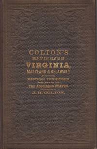
Colton's New Topographical Map of the States of Virginia, Maryland and Delaware, showing also eastern Tennessee, and parts of other adjoining states; all the Fortifications, Military Stations, Rail Roads, Common Roads and other internal improvements.; [Cover reads: Colton's Map of the States of Virginia, Maryland and Delaware...]
de Colton, J.H.
- Usado
- very good
- Tapa dura
- Estado
- Usado - Very Good
- Encuadernación
- Hardcover
- Cantidad disponible
- 1
- Librería
-
Charlottesville, Virginia, United States
- Precio
-
EUR 2,835.60
Mostrar detalles
Descripción:
New York: J.H. Colton, 1864. Brown pebbled cloth cover stamped in blind and gilt is in pristine condition. 82 x 110 cm unfolded; 10 x 16 cm folded. Full original hand coloring on onion-skin paper. Very Good. Professionally repaired tear around section attaching to the board, and extending beneath the cartouche (hardly noticeable from the front), minor spotting beneath the cartouche. Note that this is not backed with linen as some folding maps are; the paper is nearly onion skin and while not brittle is fragile. We do not recommend that it be flattened for framing. A highly important folding pocket map to be used in the field during the Civil War, in extraordinary condition. LC Civil War Maps 48.2. OCLC lists only five locations for the 1864 edition: LC, Yale, Penn State, Library of Virginia and Wake Forest. Americana Exchange records only one auction record in the last 15 years, and only two before that.
Precio
EUR 2,835.60
Más fotos
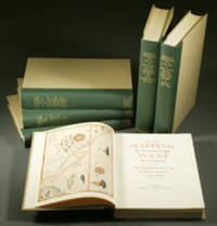
Mapping the Transmississippi West, 1540–1861,
de Wheat, Carl Irving (1892-1966)
- Usado
- near fine
- Tapa dura
- First
- Estado
- Usado - Near Fine
- Edición
- First
- Encuadernación
- Hardcover
- Cantidad disponible
- 1
- Librería
-
Fort Worth, Texas, United States
- Precio
-
EUR 2,599.30
Mostrar detalles
Descripción:
From the Spanish discovery to the opening of the Civil War5 volumes in 6. Volume One: The Spanish Entrada to the Louisiana Purchase 1540-1804 xiv+264 pages with color frontispiece map and 275 maps (many folding) and index; Volume Two: From Lewis and Clark to Fremont 1804-1845 xiii+281 pages with colored frontispiece map, 143 additional maps (some folding) and index. Volume Three: From the Mexican War to the Boundary Surveys 1846-1854 xiii+349 pages with colored frontispiece map, 322 additional maps and index; Volume Four: From the Pacific Railroad Surveys to the Onset of the Civil War 1855-1860 xiii+260 pages with color frontispiece map, an additional 127 maps (some folding) and index; Volume Five From the Civil War to the Geological Survey, Part One: xviii+222 pages with color frontispiece map and an additional 152 maps; Volume Five From the Civil War to the Geological Survey, Part Two: [223]-487 pages with 124 maps and index. Folio (14 1/2" x 10 1/2") bound in quarter green leather with gilt…
Leer más Precio
EUR 2,599.30

Más fotos
A System of Geography: or, A New & Accurate Description of the Earth in all its Empires, Kingdoms and States. Illustrated with History and Topography and Maps of every Country. Fairly engraven on copper, according to the latest discoveries and Corrections
de Moll, Herman and Rober Falconer
- Usado
- First
- Estado
- Usado
- Edición
- First Edition
- Encuadernación
- Unknown
- Cantidad disponible
- 1
- Librería
-
Scottsdale, Arizona, United States
- Precio
-
EUR 1,772.25
Mostrar detalles
Descripción:
London: For A. and J. Churchil and T. Childe, 1701. First Edition. Folio. From the library of John, Earl of Loudoun (John Campbell, Fourth Earl of Loudoun (5 May 1705 - 27 Apr. 1782) In 1727, Campbell entered the Army. He was commissioned major general in 1755, and appointed the following year as commander-in-chief of British forces in America during the French and Indian War, and named titular governor of Virginia. Variant issue, with both Churchil & Childe in imprint, 2 parts in 1 volume. Frontispiece, title page in red and black, 4; [24] contents, 444pp; 1-230; [28]pp. index. While the collation is haphazard, the book itself is complete with all catchwords matching, (with dupicate 125 pagination as in all copies) Frontispiece, 2 Engravings of Ptolomei and Copernici systems; 2 engraved compasses; and 44 textual maps, (45 maps if one counts the small china strip map).Contains the following maps. 1. Earth 2. Europe 3. Britain 4.Scotland 5. Ireland 6. France 7. Netherlands 8. United…
Leer más Precio
EUR 1,772.25

(City / Town Plan - Toledo, Spain): Toletum
de Braun, Georg and Hogenberg, Franz
- Usado
- Estado
- Usado
- Encuadernación
- Unknown
- Cantidad disponible
- 1
- Librería
-
Crozet, Virginia, United States
- Precio
-
EUR 1,701.36
Mostrar detalles
Descripción:
Braun & Hogenberg, 1598. Near fine, early color, latin edition (applicable text verso). Very decorative town plan of Toledo, Spain from this edition of the famous city atlas. Cherubim, palace, temple all present as separate images. These plans are well-known to collectors, and this particular item is increasingly uncommon. The full atlas was published in 6 volumes, in various editions, from 1572-1617. It was a collaborative work between many artists, engravers and cartographers (for a nice discussion of the history of this atlas, see Goss's THE MAPMAKERS ART, pp. 260-5). The map image measures 12.75x20 inches..
Precio
EUR 1,701.36

(Old World hemispheric map with climatic zones): Hemisphaerium Orbis Antiqui, Cumzonis, Circulis, Et Situ Populorum Diverso
de Valk, Gerard and Schenk, Petrus [Cellarius, Andreas]
- Usado
- Estado
- Usado
- Encuadernación
- Unknown
- Cantidad disponible
- 1
- Librería
-
Crozet, Virginia, United States
- Precio
-
EUR 2,528.41
Mostrar detalles
Descripción:
Amsterdam: Schenk and Valk, 1708. Very good, minimal foxing, early color copperplate from this 1708 (original version published in 1660 by Jansson) Schenk/Valk issue of (Andreas Cellarius') "Harmonia Macrocosmica Seu Atlas Universalis Et Novus." The striking image measures 41 x 51 cm on a sheet 50 x 59 cm. Numerous cherubim surrond the eastern hemispheric view, which is also divided into frigid, termperate, tropical and torrid zones. There are separate armillary and habitat zonal spheres in the lower corners. Ref: Koeman, Atlantes Neerlandici, Cel.3. There are bilateral, faint water-stains in the pink circular band surrounding the map image..
Precio
EUR 2,528.41

Más fotos
Le nouveau et curieux Atlas Geographique et historique...
de Chiquet (Jacques) [Antoine Menard].
- Usado
- Tapa dura
- Estado
- Usado
- Encuadernación
- Hardcover
- Cantidad disponible
- 1
- Librería
-
Sidney, British Columbia, Canada
- Precio
-
EUR 2,126.70
Mostrar detalles
Descripción:
Paris: chez Chereanau, [1719].. Oblong small 4to. Full vellum with ties. Wear at edges, chip from fore-edge of lower front cover,blank end leaves are heavily annotated and written-upon in 18th & 19th century hands. Old stains to margins and a few maps, old paper-tape repairs to the verso of the Asia map, but generally very good. Engraved allegorical title page, 3 plates (two of globes), and 24 maps opposite explanatory text in French. 23 maps have contemporary hand-colouring in outline; a couple have attractively coloured cartouches. The Globe Terrestre map, of two hemispheres, is holed, slightly affecting the title. The map of North America shows California as an island. This is the second or third edition of this atlas, originally by Antoine Menard, first published by Chiquet in [1711 & 1713], with most of the maps dated 1709-1711. In this 1719 edition Chiquet has removed Menard's name entirely; on many of the maps (such as L'Amerique Septentrionale) he has changed it to his own name and altered…
Leer más Precio
EUR 2,126.70

Más fotos
Catalogue des Cartes Géographiques, Topographiques & Marines, de la Bibliothèque du Prince Alexandre Labanoff de Rostoff, a Saint-Pétersbourg. Suivi d'une Notice de Manuscrits
- Usado
- very good
- Tapa dura
- First
- Estado
- Usado - Very Good
- Edición
- 1st Edition
- Encuadernación
- Hardcover
- Cantidad disponible
- 1
- Librería
-
Kraków, Poland
- Precio
-
EUR 2,199.25
Mostrar detalles
Descripción:
Paris: Firmin Didot, 1823 8vo (20 x 13.2 cm), VIII, 494, [2] pp, half chagrin over marbled boards, with original wrappers bound in (slightly foxed, blind collector stamps on the title and the first page). This is the catalog of the map collection of Duke Aleksandr Lobanov-Rostovsky (1788-1866), a Russian general and diplomat. The catalog was authored by the Duke himself, with assistance from Charles Piquet. This edition is one of the 230 copies privately printed by Firmin Didot.
Precio
EUR 2,199.25

Más fotos
抗美援朝時事學習地圖. [Kang Mei yuan Chao shi shi xue xi di tu]. [Current Affairs Study Map - Resisting US Aggression and Aiding Korea].
de [YA XIN CARTOGRAPHIC STUDY SOCIETY].[亞新地學社].
- Usado
- First
- Estado
- Usado
- Edición
- 1st Edition.
- Encuadernación
- Unknown
- Cantidad disponible
- 1
- Librería
-
Canberra, Australian Capital Territory, Australia
- Precio
-
EUR 1,698.95
Mostrar detalles
Descripción:
武昌.[Wuchang].: 亞新地學社.[Ya xin di xue she].. 1st Edition.. August1951.. Large detailed colour Chinese map of Korean War, folded, scale 1:15,000,000, three inset maps on corners, illustrated legend showing agricultural and mining resources lower margin, in original envelope. Some light wear along edges, small holes and wear at folds mended with archival tape, envelope torn with loss mended with archival tape. Inset map 兩個陣營力量對比 "Strength Comparison Between The Two Camps" upper left corner, scale 1: 170,000,000. The Peaceful Camp in red covering the majority of Asia and Europe, a list of 6 countries (Germany, Czech, Hungary, Romania, Bulgaria, Albania) are numbered and are also part of the Peaceful Camp. The Invader Camp in grey covering North America and small parts of Europe, a list of 3 nations (Netherlands, Belgium, Luxembourg) are numbered and are also part of the Invader Camp. Block of text in…
Leer más Precio
EUR 1,698.95

Foto de archivo: la portada puede ser diferente
A Book of Sleep
de Na, Il Sung
- Usado
- Estado
- Used - Very Good
- ISBN 10 / ISBN 13
- 9780375866180 / 0375866183
- Cantidad disponible
- 1
- Librería
-
Waltham, Massachusetts, United States
- Precio
-
EUR 0.95
Mostrar detalles
Descripción:
Knopf Books for Young Readers. Used - Very Good. All orders guaranteed and ship within 24 hours. Your purchase supports More Than Words, a nonprofit job training program for youth, empowering youth to take charge of their lives by taking charge of a business.
Precio
EUR 0.95
Foto de archivo: la portada puede ser diferente
A Book of Sleep
de Na, Il Sung
- Usado
- Estado
- Used - Good
- ISBN 10 / ISBN 13
- 9780375866180 / 0375866183
- Cantidad disponible
- 1
- Librería
-
Waltham, Massachusetts, United States
- Precio
-
EUR 0.95
Mostrar detalles
Descripción:
Knopf Books for Young Readers. Used - Good. . . All orders guaranteed and ship within 24 hours. Your purchase supports More Than Words, a nonprofit job training program for youth, empowering youth to take charge of their lives by taking charge of a business.
Precio
EUR 0.95

Foto de archivo: la portada puede ser diferente
A Step From Heaven
de Na, An
- Usado
- Estado
- Used - Good
- ISBN 10 / ISBN 13
- 9780142500279 / 0142500275
- Cantidad disponible
- 1
- Librería
-
Waltham, Massachusetts, United States
- Precio
-
EUR 0.95
Mostrar detalles
Descripción:
Speak. Used - Good. . . All orders guaranteed and ship within 24 hours. Your purchase supports More Than Words, a nonprofit job training program for youth, empowering youth to take charge of their lives by taking charge of a business.
Precio
EUR 0.95

Foto de archivo: la portada puede ser diferente
Snow Rabbit, Spring Rabbit: A Book of Changing Seasons
de Na, Il Sung
- Usado
- Estado
- Used - Good
- ISBN 10 / ISBN 13
- 9780307977908 / 0307977900
- Cantidad disponible
- 1
- Librería
-
Waltham, Massachusetts, United States
- Precio
-
EUR 0.95
Mostrar detalles
Descripción:
Knopf Books for Young Readers. Used - Good. . . All orders guaranteed and ship within 24 hours. Your purchase supports More Than Words, a nonprofit job training program for youth, empowering youth to take charge of their lives by taking charge of a business.
Precio
EUR 0.95
Foto de archivo: la portada puede ser diferente
A Step From Heaven
de Na, An
- Usado
- Estado
- Used - Very Good
- ISBN 10 / ISBN 13
- 9780142500279 / 0142500275
- Cantidad disponible
- 1
- Librería
-
Waltham, Massachusetts, United States
- Precio
-
EUR 1.11
Mostrar detalles
Descripción:
Speak. Used - Very Good. . . All orders guaranteed and ship within 24 hours. Your purchase supports More Than Words, a nonprofit job training program for youth, empowering youth to take charge of their lives by taking charge of a business.
Precio
EUR 1.11

Foto de archivo: la portada puede ser diferente
Little White Duck: A Childhood in China
de Liu, Na
- Usado
- Estado
- UsedGood
- ISBN 10 / ISBN 13
- 9780761381150 / 0761381155
- Cantidad disponible
- 1
- Librería
-
Imperial, Missouri, United States
- Precio
-
EUR 4.17
Mostrar detalles
Descripción:
UsedGood.
Precio
EUR 4.17

WIR: Wir. Grundkurs Deutsch f�r junge Lerner 2. Lehrbuch. Alle Bundesl�nder. (Lernmaterialien)
de NA
- Usado
- good
- Tapa blanda
- Estado
- Usado - Good
- Encuadernación
- Paperback
- ISBN 10 / ISBN 13
- 9783126757607 / 312675760x
- Cantidad disponible
- 1
- Librería
-
Chicago, Illinois, United States
- Precio
-
EUR 1.41
Mostrar detalles
Descripción:
Paperback. Good. 0.3100 in x 10.2400 in x 7.5600 in.
Precio
EUR 1.41

Foto de archivo: la portada puede ser diferente
Eat Smart
de NA
- Usado
- very good
- Tapa dura
- Estado
- Usado - Very Good
- Encuadernación
- Hardcover
- ISBN 10 / ISBN 13
- 9780008203801 / 0008203806
- Cantidad disponible
- 1
- Librería
-
Chicago, Illinois, United States
- Precio
-
EUR 1.41
Mostrar detalles
Descripción:
HARPER COLLINS, 2016-09-08. Hardcover. Very Good. 1.0236 in x 9.8819 in x 7.6772 in.
Precio
EUR 1.41
The A to Z Knock-Knock Joke Book
de NA
- Usado
- good
- Tapa blanda
- Estado
- Usado - Good
- Encuadernación
- Paperback
- ISBN 10 / ISBN 13
- 9781684642106 / 1684642108
- Cantidad disponible
- 1
- Librería
-
HILLSIDE, New Jersey, United States
- Precio
-
EUR 1.42
Mostrar detalles
Descripción:
Kane Miller Books / EDC Publishi, 2022T. paperback. Good. 0.1969 in x 6.8898 in x 6.8898 in. Bumps on corners* Crease on cover*
Precio
EUR 1.42
Everyday Kindness: 365 ways to a peaceful life (365 Ways to Everyday...)
de NA
- Usado
- Estado
- UsedGood
- ISBN 10 / ISBN 13
- 9780753732694 / 0753732696
- Cantidad disponible
- 1
- Librería
-
Imperial, Missouri, United States
- Precio
-
EUR 4.27
Mostrar detalles
Descripción:
UsedGood. The item shows wear from consistent use, but it remains in good condition and works perfectly. All pages and cover are intact (including the dust cover, if applicable). Spine may show signs of wear. Pages may include limited notes and highlighting. May NOT include discs, access code or other supplemental materials.
Precio
EUR 4.27

Más fotos
The Sky and the Forest
de Forester, C.S
- Usado
- very good
- Tapa dura
- First
- Estado
- Usado - Very Good
- Estado de la sobrecubierta
- Very Good
- Edición
- First Edition
- Encuadernación
- Hardcover
- Cantidad disponible
- 1
- Librería
-
Salem, Oregon, United States
- Precio
-
EUR 32.98EUR 19.78¡Ahorra EUR 13.96!
Mostrar detalles
Descripción:
C.S. Forester: The Sky and the Forest. Little, Brown and Company, Boston. Stated First Edition First Printing Thus August, 1948. Cover price $2.75. Used. VG BOOK/VG UNCLIPPED DUST JACKET. A story of a central Africa. By C.S. Forester, author of the Admiral Hornblower series.
Precio
EUR 32.98EUR 19.78
¡Ahorra EUR 13.96
!
![Alaska and Klondike Region; [With inset of Klondike Region on the Upper Yukon detail] [From an...](https://d3525k1ryd2155.cloudfront.net/h/062/537/1339537062.0.m.jpg)
Alaska and Klondike Region; [With inset of Klondike Region on the Upper Yukon detail] [From an atlas, "Gazetteer of Alaska and Yukon Region " pp. 105 and 106]
de Miller, J. Martin
- Usado
- very good
- Estado
- Usado - Very Good
- Edición
- Unknown
- Cantidad disponible
- 1
- Librería
-
Sebastopol, California, United States
- Precio
-
EUR 36.86
Mostrar detalles
Descripción:
Chicago: J. Martin Miller, 1899. Unknown. Map. Very Good. [Map copyright 1899, printing date of Atlas later] [19.875x15.125in]; Colored map of Alaska with steamer routes from Portland and Seattle, insets of the Klondike Region on the Upper Yukon and Western portion of Aleutian Islands; On verso index of places and names with two large black and white images; Age toning to all edges, water stain marks on bottom, slight printing offset of colors, small chips and closed tears to lower edge;.
Precio
EUR 36.86

Zemepis Sveta - Monsunova Asie
de De La Blache, P. Vidal; Gallois, L
- Usado
- Tapa dura
- Estado
- Usado - Very Good Condition
- Estado de la sobrecubierta
- No Dust Jacket
- Encuadernación
- Hardcover
- Cantidad disponible
- 1
- Librería
-
Oak Point, Texas, United States
- Precio
-
EUR 56.71
Mostrar detalles
Descripción:
Aventinum, Prague, Czechoslovakia, 1930. Hardcover. Very Good Condition/No Dust Jacket. Text entirely in Czech. Geography book on Asia with numerous photographs and maps. 1931 edition also available. Size: 4mo - over 9 3/4" - 12" tall. 400 pp. Pages are yellowed, but are tight and clean. Moderate shelfwear along the spine. Corners are lightly bumped. Quantity Available: 1. Shipped Weight: 3-5 pounds. Category: Travel & Places; Non-English Language::Czech; Pictures of this item not already displayed here available upon request. Inventory No: 001227. . Additional shipping charges may apply.
Precio
EUR 56.71

Zemepis Sveta - Monsunova Asie
de De La Blache, P. Vidal; Gallois, L
- Usado
- Tapa dura
- Estado
- Usado - Very Good Condition
- Estado de la sobrecubierta
- No Dust Jacket
- Encuadernación
- Hardcover
- Cantidad disponible
- 1
- Librería
-
Oak Point, Texas, United States
- Precio
-
EUR 56.71
Mostrar detalles
Descripción:
Aventinum, Prague, Czechoslovakia, 1931. Hardcover. Very Good Condition/No Dust Jacket. Text entirely in Czech. Geography book on Asia with numerous photographs and maps. 1930 edition also available. Size: 4mo - over 9 3/4" - 12" tall. 400 pp. Pages are yellowed, but are tight and clean. Moderate shelfwear along the spine. Corners are lightly bumped. Quantity Available: 1. Shipped Weight: 3-5 pounds. Category: Travel & Places; Non-English Language::Czech; Pictures of this item not already displayed here available upon request. Inventory No: 001228. . Additional shipping charges may apply.
Precio
EUR 56.71

Asia from the Best Authorities, Russell, ca.1800
de Russell
- Usado
- Estado
- Usado
- Cantidad disponible
- 1
- Librería
-
Plymouth, Devon, United Kingdom
- Precio
-
EUR 23.65
Mostrar detalles
Descripción:
Russell, J. : Asia from the Best Authorities. Nd but ca.1800. From "A New Geographical, Historical and Commercial Grammar and Present State of Several Kingdoms of the World". Copper engraving. Size approx 200 x 230mm. Two neat folds. Some age colouring to edges, otherwise clean and bright. Includes Arabia, India, Borneo, Japan, China and eastern Russia.
Precio
EUR 23.65

North America from the Best Authorities, Russell, ca.1800
de Russell
- Usado
- Estado
- Usado
- Cantidad disponible
- 1
- Librería
-
Plymouth, Devon, United Kingdom
- Precio
-
EUR 23.65
Mostrar detalles
Descripción:
Russell, J. : A General Map of North America from the Best Authorities. Nd but ca.1800. From "A New Geographical, Historical and Commercial Grammar and Present State of Several Kingdoms of the World." Copper engraving. Size approx 200 x 230mm. Two neat folds. Some age colouring to edges, otherwise very clean and bright.
Precio
EUR 23.65
![MAP OF UTAH [Territory]](https://d3525k1ryd2155.cloudfront.net/h/836/461/1485461836.0.m.jpg)
Más fotos
MAP OF UTAH [Territory]
- Usado
- Estado
- Usado - Very Good-
- Edición
- Original
- Cantidad disponible
- 1
- Librería
-
Williamsburg, Virginia, United States
- Precio
-
EUR 61.44
Mostrar detalles
Descripción:
New York, Richmond, Chicago, & Toledo: H. H. Hardesty, 1885. Original color lithographed map printed by Rand, McNally & Company, Engravers and published in HARDESTY'S HISTORICAL AND GEOGRAPHICAL ENCYCLOPEDIA: SPECIAL VIRGINIA EDITION. 19 3/8 inches by 13 1/4 inches on a 21" X 14 1/2" sheet. The map depicts the Territory of Utah in its final form--large areas had been removed and ceded to Nevada, Colorado, Wyoming, and Nebraska since Utah became a U. S. Territory in 1850. The issue of polygamy prevented statehood until it was finally granted in 1896. This map features railroads and topography and uses color to set off counties from each other. Unlike most atlas maps of the period, this map identifies most small towns. The map is guaranteed to be moe than 135 years old. The map is in about very good condition: generally clean and bright, with slight toning of paper and one faint water stain near the center-left edge of the map.. Original. Single Sheet. Very Good-. Elephant…
Leer más Precio
EUR 61.44

Philips Special Map of the Nile, The Advance on Khartum and the Environs of Omdurman. Cc1900
de George Philips and Son,
- Usado
- Estado
- Usado
- Cantidad disponible
- 1
- Librería
-
Plymouth, Devon, United Kingdom
- Precio
-
EUR 30.74
Mostrar detalles
Descripción:
Philips Special map of the Nile illustrating the Advance on Khartum [Khartoum] with an enlargement of the environs of Omdurman [Omdur]. George Philips and Son, London and Liverpool Ca 1900. 580mm x 900mm folded map. Front title wrapper has come loose, not affecting map area. Three maps are displayed within the sheet. Map1. Map of the Nile Valley 520mm x 300mm showing the approaches of Khartum. Scale 1inch to 100 Geographical miles. Coloured indicating Possessions and Protectorates of European Powers. Map 2. Special map of the Nile from Dongola to Khartum. Scale 16 miles to the inch. Coloured. In set in this map is Map3. Environs of Omdurman, Scale 5 statute miles to the inch. Some small breaks at some folds, not affecting imagery or use of map. Title label is damaged, the map is clean and bright, probably unused. A very interesting record.
Precio
EUR 30.74

Last Tales
de Dinesen, Isak
- Usado
- very good
- Tapa dura
- First
- Estado
- Usado - Very Good
- Estado de la sobrecubierta
- Good+
- Edición
- First Edition
- Encuadernación
- Hardcover
- Cantidad disponible
- 1
- Librería
-
Salem, Oregon, United States
- Precio
-
EUR 113.42EUR 68.05¡Ahorra EUR 48.00!
Mostrar detalles
Descripción:
Dinesen, Isak: Last Tales, A Collection of Twelve New Tales of Compelling Beauty 1957, Random House. First Edition. Stated First Printing Thus. Used. Very Good/Good+ original red dust jacket, price-clipped. Jacket states 11/57 on front flap. 5 3/4 X
Precio
EUR 113.42EUR 68.05
¡Ahorra EUR 48.00
!

The Adventure of Wrangel Island
de Vilhjalmur Stefansson
- Usado
- good
- Tapa dura
- First
- Estado
- Usado - Good
- Estado de la sobrecubierta
- No DJ Included
- Edición
- First Edition
- Encuadernación
- Hardcover
- Cantidad disponible
- 1
- Librería
-
Salem, Oregon, United States
- Precio
-
EUR 118.05EUR 70.82¡Ahorra EUR 49.96!
Mostrar detalles
Descripción:
The Adventure of Wrangel Island, Alaska (1925 Macmillan 1st Edition) HISTORY OF ALASKA. EXLIB. Good Condition/ No DJ included. Fold-out map affixed to binding at the back of the book has never been opened. The story of the (unsuccessful) attempted colonization of Wrangel Island Alaska. 413 pages plus appendix, Index. Titling is still bright. A clean, solid copy. Scarce.
Precio
EUR 118.05EUR 70.82
¡Ahorra EUR 49.96
!