Ver a tamaño completo.


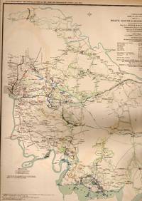
MAP: 5 Section Maps including White House to Harrison's Landing, Virginia; Seigne of Yorkstown, Williamsburg to White House, and 2 of Mulberry Island, Virginia
de United States War Department
- Usado
- very good
- Tapa blanda
- First
- Estado
- Very Good
- Librería
-
Hagerstown, Maryland, United States
Formas de pago aceptadas
Sobre este artículo
Washington, D.C.: Government Printing Office, 1891. 1swt thus edition printing; Plate XIX....From the Atlas to Accompany the Official Records of the Union and Confederate Armies, 1861-1865..single sheet, lovely, and suitable for framing. 1st. Unbound. Very Good. Illus. by Colored Map. 18" x 29".
Reseñas
(¡Iniciar sesión or Crear una cuenta primero!)
Detalles
- Librería
- Dorley House Books
 (US)
(US)
- Inventario del vendedor #
- 031849
- Título
- MAP: 5 Section Maps including White House to Harrison's Landing, Virginia; Seigne of Yorkstown, Williamsburg to White House, and 2 of Mulberry Island, Virginia
- Autor
- United States War Department
- Ilustrador
- Colored Map
- Formato/Encuadernación
- Tapa blanda
- Estado del libro
- Usado - Very Good
- Edición
- 1st
- Editorial
- Government Printing Office
- Lugar de publicación
- Washington, D.C.
- Fecha de publicación
- 1891
- Palabras clave
- Civil War; Fort Fisher , North Carolina
- Size
- 18" x 29"
Términos de venta
Dorley House Books
30 day return guarantee, with full refund including original shipping costs for up to 30 days after delivery if an item arrives misdescribed or damaged.
Sobre el vendedor
Dorley House Books
Miembro de Biblio desde 2017
Hagerstown, Maryland
Sobre Dorley House Books
We sell Rare, out-of-print, uncommon, & used BOOKS, PRINTS, MAPS, DOCUMENTS, AND EPHEMERA. We do not sell ebooks, print on demand, or other reproduced materials. Each item you see here is individually described and imaged. We welcome further inquiries, but prefer email rather than phone calls.
Glosario
Algunos términos que podrían usarse en esta descripción incluyen: