Descripción:
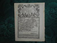
London: John Owen. Near Fine with no dust jacket. 1720. Unknown. Paperback. Attractive ORIGINAL antique county map of Carmarthenshire, from Britannia Depicta, or 'Ogilby Improved' by Owen/Bowen 1720. Engraved surface of map; approx 12 cm x 18.5 cm. Copper engraving. Unmounted, Uncoloured. Decorative and finely engraved cartouche about the county map. Underneath the map = details of the county, size, climate, industry; commerce. With black and white strip road map on verso of map: Buxton - Darby. Very good condition. This is page 243/244 from the Britannia Depicta Atlas - the maps were engraved on both sides of each page by Emanuel Bowen who was one of the most skilled and prolific engravers of the 18th Century. The maps can be double glazed, thus the customer has a choice of two maps. The publisher of the Atlas was a John Owen, hence the term Owen and Bowen to describe maps from the work. The appreciation rate of this series of maps over the past 20 years has been remarklable.…
Leer más A Map of Cornwall de BOWEN, Emanuel & OWEN, John - 1720
de BOWEN, Emanuel & OWEN, John
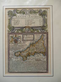
A Map of Cornwall
de BOWEN, Emanuel & OWEN, John
- Usado
- very good
1720. Map. Very Good. Dimensions : 112 x 185 mm. Hand coloured. A miniature copper engraved map, with pretty hand colouring, from " Britannia Depicta, " which was published in a several editions throughout the eighteenth century. A busy map which is contained within a decorative border, the map is surrounded with much printed topographical information, also the Royal Standard is towards one corner. Above the map surrounded by a rococo strap work border is a distance table for the Road from Exeter to Truro, listing the towns on route. Mounted and wrapped in cling film.
-
Librería
Independent bookstores
 (GB)
(GB)
- Formato/Encuadernación Map
- Estado del libro Usado - Very Good
- Cantidad disponible 1
- Fecha de publicación 1720
- Palabras clave MAPS, TOPOGRAPHY, CORNWALL, CARTOGRAPHY. CORNISH MAPS.
Más fotos
Original Owen & Bowen Antique Map of CARMARTHENSHIRE. Circa. 1720 From Britannia Depicta, or ' Ogilby Improved '
de Owen John and Emanuel Bowen
- Usado
- Tapa blanda
- Estado
- Usado - Near Fine with no dust jacket
- Edición
- Unknown
- Encuadernación
- Paperback
- Cantidad disponible
- 1
- Librería
-
Carmarthen, United Kingdom
- Precio
-
EUR 35.54
Mostrar detalles
Precio
EUR 35.54
Más fotos
Original Owen & Bowen Antique Map of MONTGOMERYSHIRE. Circa. 1720 From Britannia Depicta, or ' Ogilby Improved '
de Owen John and Emanuel Bowen
- Usado
- Tapa blanda
- Estado
- Usado - Near Fine with no dust jacket
- Edición
- Unknown
- Encuadernación
- Paperback
- Cantidad disponible
- 1
- Librería
-
Carmarthen, United Kingdom
- Precio
-
EUR 35.54
Mostrar detalles
Descripción:
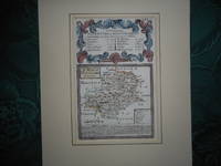
London: John Owen. Near Fine with no dust jacket. c1720. Unknown. Paperback. Attractive ORIGINAL antique county map of Montgomeryshire, from Britannia Depicta, or 'Ogilby Improved' by Owen/Bowen c. 1720. Engraved surface of map; approx 12 cm x 18.5 cm. Copper engraving. In ivory mount with copper/gold line. Mounted on one side only, hand-coloured. Decorative and finely engraved cartouche above the county map. Underneath the map = details of the county, size, climate, industry; commerce. With black and white strip road map on verso of map: Gloucester - Hereford. Very good condition. This is page 185/186 from the Britannia Depicta Atlas - the maps were engraved on both sides of each page by Emanuel Bowen who was one of the most skilled and prolific engravers of the 18th Century. The maps can be double glazed, thus the customer has a choice of two maps. The publisher of the Atlas was a John Owen, hence the term Owen and Bowen to describe maps from the work. The appreciation rate of…
Leer más Precio
EUR 35.54

Más fotos
Leaf from Britannia Depicta; or, Ogilby Improv'd; Stony Stratford to Haverborough (Northampton) and from Kibworth / Leichester to Derby, (Mounted, Framed, Under glass)
de John Ogilby; JOHN OWEN and EMANUEL BOWEN
- Usado
- Estado
- Like New
- Cantidad disponible
- 1
- Librería
-
Boonsboro, Maryland, United States
- Precio
-
EUR 111.08
Mostrar detalles
Descripción:
Thomas Bowles, St Pauls Churchyard, London, 1720. Maps. Like New. [British Road Atlas of Leicester, Derby, Northampton] Original copper engraved plate from Bowen's early road atlas. 7 1/2 X 5 in. Each map with finely engraved coat of arms. Framed so that both pages 99 and 100 are shown in full. In fine condition. (not exampled out of glass)
Precio
EUR 111.08
