
Ver a tamaño completo.
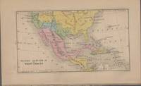
MAP OF MEXICO, GUATIMALA AND WEST INDIES
de Boynton, G. W
- Usado
- very good
- Estado
- Very Good
- Librería
-
Staunton, Virginia, United States
Formas de pago aceptadas
Sobre este artículo
Boston: Jenks, Hickling & Swan. Very Good. 1852. Map. Extracted from A History of the United States of America by Charles A. Goodrich. Single page, measuring 4.5 by 7.375 Inches, actual map is 3.25 by 6 inches. Map is hand colored. ; 12mo 7" - 7½" tall .
Reseñas
(¡Iniciar sesión or Crear una cuenta primero!)
Detalles
- Librería
- The Avocado Pit
 (US)
(US)
- Inventario del vendedor #
- 52055
- Título
- MAP OF MEXICO, GUATIMALA AND WEST INDIES
- Autor
- Boynton, G. W
- Formato/Encuadernación
- Map
- Estado del libro
- Usado - Very Good
- Cantidad disponible
- 1
- Editorial
- Jenks, Hickling & Swan
- Lugar de publicación
- Boston
- Fecha de publicación
- 1852
- Catálogos del vendedor
- Map;
Términos de venta
The Avocado Pit
All orders must be prepaid, including libraries. All orders must be confirmed within 48 hours, or book will be relisted. 10 day hold; all books returnable for any reason. Returns must be made within 10 days of receipt, and you must email us first that you are making a return. All books subject to prior sale. All funds MUST be in U.S. currency. If you are looking for BookTrakker Pro please go to: http://www.booktrakker.com/
Sobre el vendedor
The Avocado Pit
Miembro de Biblio desde 2003
Staunton, Virginia
Sobre The Avocado Pit
General stock, mostly nonfiction.
Glosario
Algunos términos que podrían usarse en esta descripción incluyen:
- 12mo
- A duodecimo is a book approximately 7 by 4.5 inches in size, or similar in size to a contemporary mass market paperback. Also...