Descripción:
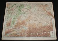
The Times, London, 1920. First Edition. Softcover. Very Good Condition/No Dust Jacket. Map Disbound single sheet with vertical centre fold from the 1920 "The Times Survey Atlas of the World". Map is in colour and suitable for framing. Colour is according to contour, boundaries of countries and regions are in red. Map at scale 1:1,000,000. Map covers Schwarzwald, Wurtemberg, Franconia, Bavaria, Palatinate, parts of Czecho-Slovakia, Austria, Switzerland and France, cities include Munich, Nurnberg, Salzburg, Pilsen, Frankfurt, Manheim, Wiesbaden, Ulm, Strasbourg, Zurich, Lucerne, Basel, Mulhouse, Stuttgart, Karlsruhe, Bern, etc. Slightly darkened edges with foxing in margins, sheet is otherwise clean and crisp. Item Type: Map. Single sheet map/chart which is suitable for framing and will be shipped rolled and in a cardboard tube. Quantity Available: 1. Shipped Weight: under 1 kg. Pictures of this item not already displayed here available upon request. Inventory No: 45020034056. For…
Leer más Map of "Siberia" (modern day Russia, Kazakhstan and Uzbekistan) from the 1920 Times Survey Atlas (Plate 67) including Mongolia, Korea, Manchuria, Turkestan, Petrograd, Vladivostok, Lapland, etc de The Times and J. G. Bartholomew - 1920
de The Times and J. G. Bartholomew
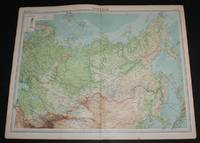
Map of "Siberia" (modern day Russia, Kazakhstan and Uzbekistan) from the 1920 Times Survey Atlas (Plate 67) including Mongolia, Korea, Manchuria, Turkestan, Petrograd, Vladivostok, Lapland, etc
de The Times and J. G. Bartholomew
- Usado
- Tapa blanda
- First
The Times, London, 1920. First Edition. Softcover. Very Good Condition/No Dust Jacket. Map Disbound single sheet with vertical centre fold from the 1920 "The Times Survey Atlas of the World". Map is in colour and suitable for framing. Colour on both land and sea is by contour, borders are in red. Map at scale 1:14,000,000. Map covers Siberia, Russia (part), Mongolia, Manchuria, Turkestan, Yakutsk, Kamchatka Province, Korea, Japan (part), Yeniseisk, Tobolsk, Irkutsk, Khiva, Bokhara Transbaikalia, Novaya Zemlya, Franz Josef Land, Nicholas II Land, Spitsbergen, Sweden (part), Petrograd, Vladivostok, Lapland, Arctic Ocean (part), Barents Sea, White Sea, Kara Sea, Nordenskiold Sea, Sea of Okhotsk, Aral Sea, Sea of Japan, etc. Slightly darkened edges with occasional light foxing in margins. Top edge very slightly bumped, sheet is otherwise clean and crisp. Item Type: Map. Single sheet map/chart which is suitable for framing and will be shipped rolled and in a cardboard tube. Quantity Available: 1. Shipped Weight: under 1 kg. Pictures of this item not already displayed here available upon request. Inventory No: 45020034048..
-
Librería
Bailgate Books Ltd
 (GB)
(GB)
- Formato/Encuadernación Softcover
- Estado del libro Usado - Very Good Condition
- Estado de la sobrecubierta No Dust Jacket
- Cantidad disponible 1
- Edición First Edition
- Encuadernación Tapa blanda
- Editorial The Times
- Lugar de publicación London
- Fecha de publicación 1920
- Palabras clave BZDB4 NOISBN Maps; China, Japan, Nepal & Tibet; World History; Russia & Eastern Europe. Map of Siberia modern day Russia Kazakhstan and Uzbekistan from the 1920 Times Survey Atlas Plate 67 including Mongolia Korea Manchuria Turkestan Petrograd Vla
Más fotos
Map of "Germany - Southern Section" from 1920 Times Survey Atlas (Plate 39) including Munich, Nurnberg, Salzburg, Pilsen, Frankfurt, Manheim, Wiesbaden, Strasbourg, Zurich, Lucerne, Basel, Mulhouse, Stuttgart, Karlsruhe, Bern, etc
de The Times and J. G. Bartholomew
- Usado
- Tapa blanda
- First
- Estado
- Usado - Very Good Condition
- Estado de la sobrecubierta
- No Dust Jacket
- Edición
- First Edition
- Encuadernación
- Paperback
- Cantidad disponible
- 1
- Librería
-
Doncaster, Aberdeen, United Kingdom
- Precio
-
EUR 23.64
Mostrar detalles
Precio
EUR 23.64

Más fotos
Map of Alberta and Saskatchewan, Canada from the 1920 Times Survey Atlas (Plate 88) including part of Manitoba
de The Times and J. G. Bartholomew
- Usado
- Tapa blanda
- First
- Estado
- Usado - Very Good Condition
- Estado de la sobrecubierta
- No Dust Jacket
- Edición
- First Edition
- Encuadernación
- Paperback
- Cantidad disponible
- 1
- Librería
-
Doncaster, Aberdeen, United Kingdom
- Precio
-
EUR 23.64
Mostrar detalles
Descripción:
The Times, London, 1920. First Edition. Softcover. Very Good Condition/No Dust Jacket. Map Disbound single sheet with vertical centre fold from the 1920 "The Times Survey Atlas of the World". Map is in colour and suitable for framing. Colour according to contour. Map at scale 1:2,500,000. Map covers; Alberta (part), Saskatchewan (as far north as Frobisher Lake only), Manitoba (part), Lake Winnipeg (part), USA Border, Montanna (part), North Dakota (part), Edmonton, Calgary, Rocky Mountains (part), Regina, Saskatoon, Brandon, etc. Slightly darkened edges but sheet is otherwise clean and crisp. Item Type: Map. Single sheet map/chart which is suitable for framing and will be shipped rolled and in a cardboard tube. Quantity Available: 1. Shipped Weight: under 1 kg. Pictures of this item not already displayed here available upon request. Inventory No: 45020034019. For international tracking please select Priority shipping service..
Precio
EUR 23.64

Más fotos
Map of Eastern China from the 1920 Times Survey Atlas (Plate 64) including Hankow, Anking, Nanking, Hangchow, Shanghai, Ningpo, Foochow, Canton, Hong Kong, Peking, Tientsin, Tsinan, Amoy and Taiwan (Formosa)
de The Times and J. G. Bartholomew
- Usado
- Tapa blanda
- First
- Estado
- Usado - Very Good Condition
- Estado de la sobrecubierta
- No Dust Jacket
- Edición
- First Edition
- Encuadernación
- Paperback
- Cantidad disponible
- 1
- Librería
-
Doncaster, Aberdeen, United Kingdom
- Precio
-
EUR 23.64
Mostrar detalles
Descripción:
The Times, London, 1920. First Edition. Softcover. Very Good Condition/No Dust Jacket. Map Disbound single sheet with vertical centre fold from the 1920 "The Times Survey Atlas of the World". Map is in colour and suitable for framing. Province boundaries are marked in different colours with colour infill in matching paler colours, seas are coloured blue. Map at scale 1:3,000,000 and split over two continuation panels. Map covers Kiangsi, Anhwei, Shantung, Fukien, Kwangtung, Chekiang, Chinli, Kiangsu, Hankow, Anking, Nanking, Hangchow, Shanghai, Ningpo, Foochow, Canton, Hong Kong, Peking, Tientsin, Tsinan, Amoy, Taiwan (Formosa), Gulf of Pechihli, Gulf og Liaotung, etc. Slightly darkened edges with occasional light foxing in margins, sheet is otherwise clean and crisp. Item Type: Map. Single sheet map/chart which is suitable for framing and will be shipped rolled and in a cardboard tube. Quantity Available: 1. Shipped Weight: under 1 kg. Pictures of this item not already displayed here…
Leer más Precio
EUR 23.64

Más fotos
Map of Manitoba and North-West Ontario, Canada from the 1920 Times Survey Atlas (Plate 87)
de The Times and J. G. Bartholomew
- Usado
- Tapa blanda
- First
- Estado
- Usado - Very Good Condition
- Estado de la sobrecubierta
- No Dust Jacket
- Edición
- First Edition
- Encuadernación
- Paperback
- Cantidad disponible
- 1
- Librería
-
Doncaster, Aberdeen, United Kingdom
- Precio
-
EUR 23.64
Mostrar detalles
Descripción:
The Times, London, 1920. First Edition. Softcover. Very Good Condition/No Dust Jacket. Map Disbound single sheet with vertical centre fold from the 1920 "The Times Survey Atlas of the World". Map is in colour and suitable for framing. Colour according to contour. Map at scale 1:2,500,000. Map covers; Manitora (as far north as Clearwater Lake only), Ontario (part), North Dakota (part), Minnesota (part), Lake Winnipeg, Lake Superior, Lake Nipigon, Brandon, Winnipeg, Fort William, Sault Ste Marie, Albany River, Duluth, etc. Slightly darkened edges with very occasional light foxing in margins but sheet is otherwise clean and crisp. Item Type: Map. Single sheet map/chart which is suitable for framing and will be shipped rolled and in a cardboard tube. Quantity Available: 1. Shipped Weight: under 1 kg. Pictures of this item not already displayed here available upon request. Inventory No: 45020034020. For international tracking please select Priority shipping service..
Precio
EUR 23.64
Más fotos
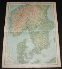
Map of "Southern Scandinavia & Denmark" from 1920 Times Survey Atlas (Plate 42) including Southern Norway and Sweden, Copenhagen, Goteborg, Malmo, Stockholm, Kristiania, Bergen, Krisiansund, Hernosand, etc
de The Times and J. G. Bartholomew
- Usado
- Tapa blanda
- First
- Estado
- Usado - Very Good Condition
- Estado de la sobrecubierta
- No Dust Jacket
- Edición
- First Edition
- Encuadernación
- Paperback
- Cantidad disponible
- 1
- Librería
-
Doncaster, Aberdeen, United Kingdom
- Precio
-
EUR 23.64
Mostrar detalles
Descripción:
The Times, London, 1920. First Edition. Softcover. Very Good Condition/No Dust Jacket. Map Disbound single sheet with horizontal centre fold from the 1920 "The Times Survey Atlas of the World". Map is in colour and suitable for framing. Colour is according to contour, boundaries of countries and regions are in red. Map at scale 1:2,000,000. Map covers Denmark, southern Norway, southern Sweden and parts of Schleswig-Holstein and Pomerania, towns and cities include Copenhagen, Goteborg, Malmo, Stockholm, Kristiania, Bergen, Krisiansund, Hernosand, etc. Slightly darkened edges with occasional light foxing in margins. Top and bottom edges are a little bumped, sheet is otherwise clean and crisp. Item Type: Map. Single sheet map/chart which is suitable for framing and will be shipped rolled and in a cardboard tube. Quantity Available: 1. Shipped Weight: under 1 kg. Pictures of this item not already displayed here available upon request. Inventory No: 45020034057. For international tracking…
Leer más Precio
EUR 23.64

Más fotos
Map of British Columbia, Canada from the 1920 Times Survey Atlas (Plate 89) including part of Alberta, Vancouver Island, Queen Charlotte Islands and Prince of Wales Island etc
de The Times and J. G. Bartholomew
- Usado
- Tapa blanda
- First
- Estado
- Usado - Very Good Condition
- Estado de la sobrecubierta
- No Dust Jacket
- Edición
- First Edition
- Encuadernación
- Paperback
- Cantidad disponible
- 1
- Librería
-
Doncaster, Aberdeen, United Kingdom
- Precio
-
EUR 23.64
Mostrar detalles
Descripción:
The Times, London, 1920. First Edition. Softcover. Very Good Condition/No Dust Jacket. Map Disbound single sheet with vertical centre fold from the 1920 "The Times Survey Atlas of the World". Map is in colour and suitable for framing. Colour on both land and sea according to contour. Map at scale 1:2,500,000. Map covers; British Columbia (as far North as Zarembo Island), Alberta (part), Rocky Mountains, Vancouver Island, US Border, Washington (part), Idaho (part), Montana (part), Calgary, Edmonton, Lesser Slave Lake, Graham Island, Hecate Strait, Strait of Juan de Fuca, Fraser River, etc. Sheet contains small inset map of Vancouver and New Westminster at 1:500,000. Slightly darkened edges and occasional light foxing in margins but sheet is otherwise clean and crisp. Item Type: Map. Single sheet map/chart which is suitable for framing and will be shipped rolled and in a cardboard tube. Quantity Available: 1. Shipped Weight: under 1 kg. Pictures of this item not already displayed here…
Leer más Precio
EUR 23.64

Más fotos
Map of "India - Southern Section" from the 1920 Times Survey Atlas (Plate 58) covering Mysore, Hyrerabad, Central Provinces, Ceylon (Sri Lanka), Kathainwar, Bombay, Baroda, Chota, Laccadive Islands, etc
de The Times and J. G. Bartholomew
- Usado
- Tapa blanda
- First
- Estado
- Usado - Very Good Condition
- Estado de la sobrecubierta
- No Dust Jacket
- Edición
- First Edition
- Encuadernación
- Paperback
- Cantidad disponible
- 1
- Librería
-
Doncaster, Aberdeen, United Kingdom
- Precio
-
EUR 23.64
Mostrar detalles
Descripción:
The Times, London, 1920. First Edition. Softcover. Very Good Condition/No Dust Jacket. Map Disbound single sheet with horizontal centre fold from the 1920 "The Times Survey Atlas of the World". Map is in colour and suitable for framing. Colour on both land and sea according to contour. Map at scale 1:4,000,000 with small inset map of Bombay at scale 1:340,000. Map covers; India (part), Mysore, Hyrerabad, Central Provinces, Ceylon (Sri Lanka), Colombo, Kathainwar, Bombay, Baroda, Chota, Coromandel Coast, Laccadive Islands, Bay of Bengal (part), Gulf of Cambay, Gulf of Manar, Arabian Sea (part), etc. Slightly darkened edges with occasional light foxing or staining in margins but sheet is otherwise clean and crisp. Item Type: Map. Single sheet map/chart which is suitable for framing and will be shipped rolled and in a cardboard tube. Quantity Available: 1. Shipped Weight: under 1 kg. Pictures of this item not already displayed here available upon request. Inventory No: 45020034035. For…
Leer más Precio
EUR 23.64
Más fotos
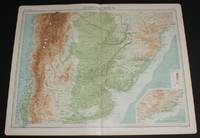
Map of Part of South America including parts of Argentina, Chile, Brazil, Paraguay and Uruguay from the 1920 Times Survey Atlas (Plate 101 Argentina, Chile, &c.)
de The Times and J. G. Bartholomew
- Usado
- Tapa blanda
- First
- Estado
- Usado - Very Good Condition
- Estado de la sobrecubierta
- No Dust Jacket
- Edición
- First Edition
- Encuadernación
- Paperback
- Cantidad disponible
- 1
- Librería
-
Doncaster, Aberdeen, United Kingdom
- Precio
-
EUR 23.64
Mostrar detalles
Descripción:
The Times, London, 1920. First Edition. Softcover. Very Good Condition/No Dust Jacket. Map Disbound single sheet with vertical centre fold from the 1920 "The Times Survey Atlas of the World". Map is in colour and suitable for framing. Colour on both land and sea according to contour. Map at scale 1:5,000,000. Map includes parts of countries in South America; Chile from San Pablo in the North to Valdivia in the South, Argentina to Bahia Blanca in the South, Uruguay, Brazil as far North as Rio de Janeiro (shown in inset map) and Paraguay. Also included is the Atlantic Ocean and Pacific Ocean coasts. Slightly darkened edges but sheet is otherwise clean and crisp. Item Type: Map. Single sheet map/chart which is suitable for framing and will be shipped rolled and in a cardboard tube. Quantity Available: 1. Shipped Weight: under 1 kg. Pictures of this item not already displayed here available upon request. Inventory No: 45020034009. For international tracking please select Priority shipping service..
Leer más Precio
EUR 23.64
Más fotos
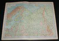
Map of "Northern Russia & Finland" from 1920 Times Atlas (Plate 45) including Moscow, Petrograd (St Petersburg) and covering Finland, Lapland, Estonia, Latvia, Lithuania and north Russia as far east as Ural Mountains and Gulf of Ob
de The Times and J. G. Bartholomew
- Usado
- Tapa blanda
- First
- Estado
- Usado - Very Good Condition
- Estado de la sobrecubierta
- No Dust Jacket
- Edición
- First Edition
- Encuadernación
- Paperback
- Cantidad disponible
- 1
- Librería
-
Doncaster, Aberdeen, United Kingdom
- Precio
-
EUR 26.01
Mostrar detalles
Descripción:
The Times, London, 1920. First Edition. Softcover. Very Good Condition/No Dust Jacket. Map Disbound single sheet with vertical centre fold from the 1920 "The Times Survey Atlas of the World". Map is in colour and suitable for framing. Colour is according to contour, boundaries of countries or regions are in red. Map at scale 1:6,000,000. Map includes Moskva/Moscow, Petrograd (St Petersburg), Riga, Warsaw, Stockholm, Helsinki, and covers Finland, Lapland, Estonia, Latvia, Lithuania and northern Russia as far east as the Ural Mountains and Gulf of Ob, Tobolsk, Vologda, Archanangel, Orenburg, White Sea, Kara Sea (part), Baltic Sea (part), Gulf of Bothnia, etc. Slightly darkened edges with occasional light foxing in margins, sheet is otherwise clean and crisp. Item Type: Map. Single sheet map/chart which is suitable for framing and will be shipped rolled and in a cardboard tube. Quantity Available: 1. Shipped Weight: under 1 kg. Pictures of this item not already displayed here available upon…
Leer más Precio
EUR 26.01

Más fotos
Map of Eastern Queensland, Australia from the 1920 Times Survey Atlas (Plate 109) including inset map of Brisbane and Environs
de The Times and J. G. Bartholomew
- Usado
- Tapa blanda
- First
- Estado
- Usado - Very Good Condition
- Estado de la sobrecubierta
- No Dust Jacket
- Edición
- First Edition
- Encuadernación
- Paperback
- Cantidad disponible
- 1
- Librería
-
Doncaster, Aberdeen, United Kingdom
- Precio
-
EUR 26.01
Mostrar detalles
Descripción:
The Times, London, 1920. First Edition. Softcover. Very Good Condition/No Dust Jacket. Map Disbound single sheet with horizontal centre fold from the 1920 "The Times Survey Atlas of the World". Map is in colour and suitable for framing. Colour on both land and sea according to contour. Map at scale 1:2,500,000 with inset of Brisbane at larger scale. Area covered includes: Innisfail, Tate, Numalla, Bentinck, Brisbane, Maryborough, Great Sandy Island, Northumberland Isles, Palm Isles, Gladstone, Mackay, Townsville, Great Dividing Range, Denham Range, Great Barrier Reef (part), etc. Slightly darkened edges and very occasional foxing but sheet is otherwise clean and crisp. Item Type: Map. Single sheet map/chart which is suitable for framing and will be shipped rolled and in a cardboard tube. Quantity Available: 1. Shipped Weight: under 1 kg. Pictures of this item not already displayed here available upon request. Inventory No: 45020034004. For international tracking please select Priority…
Leer más Precio
EUR 26.01
