Descripción:
Adamant Media Corporation, 2001-10-05. Paperback. Used: Good.
(Map of Southwestern Africa): Typus orarum maritimarum Guineae, Manicongo & Angolae ultra Promentorium Bonae spei de Linschoten, Jan (John) van Huygen - 1596
de Linschoten, Jan (John) van Huygen
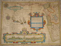
(Map of Southwestern Africa): Typus orarum maritimarum Guineae, Manicongo & Angolae ultra Promentorium Bonae spei
de Linschoten, Jan (John) van Huygen
- Usado
Amsterdam, 1596. A highly decorative map of the southwestern coast of Africa. Overall very good, with early color. Some restoration most evident central verso, few professional wormhole repairs with margins reinforced verso. The map was engraved by Florent van Langren, and the first Dutch edition of Linschoten's "Itinerario..." was published by Cornelis Claesz in 1596. There are coastal views of the islands of Ascension and St. Helena within a strapwork cartouche at the bottom of the map. This is just the western sheet. The image measures 15.25 x 20.5 inches (39 x 52 cm). Two compass roses, decorative script and sailing ships. Coastal town names go inland, in the style of earlier portolan charts..
-
Librería
The Prime Meridian: Antique Maps & Books
 (US)
(US)
- Estado del libro Usado
- Lugar de publicación Amsterdam
- Fecha de publicación 1596
- Palabras clave Africa, History of Cartography, Maps, Voyages

Foto de archivo: la portada puede ser diferente
The Voyage of John Huyghen van Linschoten to the East Indies: The first book, containing his description of the East. Volume 1
de Jan Huygen van Linschoten
- Usado
- Tapa blanda
- Estado
- Used: Good
- Encuadernación
- Paperback
- ISBN 10 / ISBN 13
- 9781402195075 / 1402195079
- Cantidad disponible
- 1
- Librería
-
HOUSTON, Texas, United States
- Precio
-
EUR 12.14
Mostrar detalles
Precio
EUR 12.14

The Voyage of John Huyghen van Linschoten to the East Indies: The first book, containing his description of the East. Volume 1
de Jan Huygen van Linschoten
- Usado
- very good
- Tapa blanda
- Estado
- Usado - Very Good
- Encuadernación
- Paperback
- ISBN 10 / ISBN 13
- 9781402195075 / 1402195079
- Cantidad disponible
- 1
- Librería
-
GORING BY SEA, West Sussex, United Kingdom
- Precio
-
EUR 9.81
Mostrar detalles
Descripción:
Paperback. Very Good.
Precio
EUR 9.81
Foto de archivo: la portada puede ser diferente
The Voyage of John Huyghen van Linschoten to the East Indies: The first book, containing his description of the East. Volume 1
de Jan Huygen van Linschoten
- Usado
- Tapa blanda
- Estado
- Used:Good
- Encuadernación
- Paperback
- ISBN 10 / ISBN 13
- 9781402195075 / 1402195079
- Cantidad disponible
- 1
- Librería
-
HOUSTON, Texas, United States
- Precio
-
EUR 22.05
Mostrar detalles
Descripción:
Adamant Media Corporation, 2001-10-05. Paperback. Used:Good.
Precio
EUR 22.05

Foto de archivo: la portada puede ser diferente
The Last Fight Of The Revenge At Sea: Under The Command Of Richard Grenville, On September 10-11, 1591 (1871)
de Walter Raleigh, Gervase Markham, Jan Huygen Van Linschoten
- Usado
- Tapa blanda
- Estado
- Used:Good
- Encuadernación
- Paperback
- ISBN 10 / ISBN 13
- 9781104660765 / 1104660768
- Cantidad disponible
- 1
- Librería
-
HOUSTON, Texas, United States
- Precio
-
EUR 23.22
Mostrar detalles
Descripción:
Kessinger Publishing, LLC, 2009-06-13. Paperback. Used:Good.
Precio
EUR 23.22
Foto de archivo: la portada puede ser diferente
The Last Fight Of The Revenge At Sea: Under The Command Of Richard Grenville, On September 10-11, 1591 (1871)
de Walter Raleigh; Gervase Markham; Jan Huygen Van Linschoten
- Usado
- good
- Tapa blanda
- Estado
- Usado - Good
- Encuadernación
- Paperback
- ISBN 10 / ISBN 13
- 9781104660765 / 1104660768
- Cantidad disponible
- 1
- Librería
-
HOUSTON, Texas, United States
- Precio
-
EUR 23.22
Mostrar detalles
Descripción:
Kessinger Publishing, LLC, 2009-06-13. Paperback. Good.
Precio
EUR 23.22

Foto de archivo: la portada puede ser diferente
Journael van de derthien-jarighe reyse, te water en te lande, gedaen door Jan Huygen van Linschooten, na Oost-Indienh: inhoudende de beschryvinge der ... inwoonders en Portugesen ... (Dutch Edition)
de Jan Huygen van Linschoten (Creator)
- Usado
- good
- Tapa blanda
- Estado
- Usado - Good
- Encuadernación
- Paperback
- ISBN 10 / ISBN 13
- 9781275701175 / 1275701175
- Cantidad disponible
- 1
- Librería
-
HOUSTON, Texas, United States
- Precio
-
EUR 30.33
Mostrar detalles
Descripción:
Gale, Sabin Americana, 2012-02-22. Paperback. Good.
Precio
EUR 30.33

Foto de archivo: la portada puede ser diferente
Early Travels In India: First Series, Comprising Purchas's Pilgrimage, And The Travels Of Van Linschoten (1864)
de Samuel Purchas, Jan Huygen Van Linschoten, James Talboys Wheeler (Foreword)
- Usado
- good
- Tapa blanda
- Estado
- Usado - Good
- Encuadernación
- Paperback
- ISBN 10 / ISBN 13
- 9781104120047 / 1104120046
- Cantidad disponible
- 1
- Librería
-
HOUSTON, Texas, United States
- Precio
-
EUR 35.47
Mostrar detalles
Descripción:
Kessinger Publishing, LLC, 2009-03-04. Paperback. Good.
Precio
EUR 35.47

Foto de archivo: la portada puede ser diferente
Early Travels In India: First Series, Comprising Purchas's Pilgrimage, And The Travels Of Van Linschoten (1864)
de Samuel Purchas, Jan Huygen Van Linschoten, James Talboys Wheeler (Foreword)
- Usado
- good
- Tapa blanda
- Estado
- Usado - Good
- Encuadernación
- Paperback
- ISBN 10 / ISBN 13
- 9781165425365 / 116542536X
- Cantidad disponible
- 1
- Librería
-
HOUSTON, Texas, United States
- Precio
-
EUR 35.47
Mostrar detalles
Descripción:
Kessinger Publishing, LLC, 2010-09-10. Paperback. Good.
Precio
EUR 35.47

The Voyage Of John Huyghen Van Linschoten To The East Indies. From The Old English Translation Of 1598 [by W. Phillip] The First Book, Containing His Description Of The East; Volume 2
de Jan Huygen Van Linschoten
- Nuevo
- Tapa blanda
- Estado
- New
- Encuadernación
- Paperback
- ISBN 10 / ISBN 13
- 9781017836301 / 1017836302
- Cantidad disponible
- 10
- Librería
-
Southport, Merseyside, United Kingdom
- Precio
-
EUR 25.83
Mostrar detalles
Descripción:
Paperback / softback. New.
Precio
EUR 25.83
Itinerario, voyage, ofte schipvaert van Jan Huygen van Linschoten naer Oost ofte Portugaels Indien, 1579-1592, uitgegeven door prof. dr. H. Kern; 05
de Jan Huygen Van 1563-1611 Linschoten
- Nuevo
- Tapa blanda
- Estado
- New
- Encuadernación
- Paperback
- ISBN 10 / ISBN 13
- 9781016914390 / 1016914393
- Cantidad disponible
- 10
- Librería
-
Southport, Merseyside, United Kingdom
- Precio
-
EUR 29.40
Mostrar detalles
Descripción:
Paperback / softback. New.
Precio
EUR 29.40

Más fotos
The Sky and the Forest
de Forester, C.S
- Usado
- very good
- Tapa dura
- First
- Estado
- Usado - Very Good
- Estado de la sobrecubierta
- Very Good
- Edición
- First Edition
- Encuadernación
- Hardcover
- Cantidad disponible
- 1
- Librería
-
Salem, Oregon, United States
- Precio
-
EUR 32.88EUR 16.45¡Ahorra EUR 17.44!
Mostrar detalles
Descripción:
C.S. Forester: The Sky and the Forest. Little, Brown and Company, Boston. Stated First Edition First Printing Thus August, 1948. Cover price $2.75. Used. VG BOOK/VG UNCLIPPED DUST JACKET. A story of a central Africa. By C.S. Forester, author of the Admiral Hornblower series.
Precio
EUR 32.88EUR 16.45
¡Ahorra EUR 17.44
!
![Alaska and Klondike Region; [With inset of Klondike Region on the Upper Yukon detail] [From an...](https://d3525k1ryd2155.cloudfront.net/h/062/537/1339537062.0.m.jpg)
Alaska and Klondike Region; [With inset of Klondike Region on the Upper Yukon detail] [From an atlas, "Gazetteer of Alaska and Yukon Region " pp. 105 and 106]
de Miller, J. Martin
- Usado
- very good
- Estado
- Usado - Very Good
- Edición
- Unknown
- Cantidad disponible
- 1
- Librería
-
Sebastopol, California, United States
- Precio
-
EUR 36.76
Mostrar detalles
Descripción:
Chicago: J. Martin Miller, 1899. Unknown. Map. Very Good. [Map copyright 1899, printing date of Atlas later] [19.875x15.125in]; Colored map of Alaska with steamer routes from Portland and Seattle, insets of the Klondike Region on the Upper Yukon and Western portion of Aleutian Islands; On verso index of places and names with two large black and white images; Age toning to all edges, water stain marks on bottom, slight printing offset of colors, small chips and closed tears to lower edge;.
Precio
EUR 36.76

Zemepis Sveta - Monsunova Asie
de De La Blache, P. Vidal; Gallois, L
- Usado
- Tapa dura
- Estado
- Usado - Very Good Condition
- Estado de la sobrecubierta
- No Dust Jacket
- Encuadernación
- Hardcover
- Cantidad disponible
- 1
- Librería
-
Oak Point, Texas, United States
- Precio
-
EUR 56.55
Mostrar detalles
Descripción:
Aventinum, Prague, Czechoslovakia, 1930. Hardcover. Very Good Condition/No Dust Jacket. Text entirely in Czech. Geography book on Asia with numerous photographs and maps. 1931 edition also available. Size: 4mo - over 9 3/4" - 12" tall. 400 pp. Pages are yellowed, but are tight and clean. Moderate shelfwear along the spine. Corners are lightly bumped. Quantity Available: 1. Shipped Weight: 3-5 pounds. Category: Travel & Places; Non-English Language::Czech; Pictures of this item not already displayed here available upon request. Inventory No: 001227. . Additional shipping charges may apply.
Precio
EUR 56.55

Zemepis Sveta - Monsunova Asie
de De La Blache, P. Vidal; Gallois, L
- Usado
- Tapa dura
- Estado
- Usado - Very Good Condition
- Estado de la sobrecubierta
- No Dust Jacket
- Encuadernación
- Hardcover
- Cantidad disponible
- 1
- Librería
-
Oak Point, Texas, United States
- Precio
-
EUR 56.55
Mostrar detalles
Descripción:
Aventinum, Prague, Czechoslovakia, 1931. Hardcover. Very Good Condition/No Dust Jacket. Text entirely in Czech. Geography book on Asia with numerous photographs and maps. 1930 edition also available. Size: 4mo - over 9 3/4" - 12" tall. 400 pp. Pages are yellowed, but are tight and clean. Moderate shelfwear along the spine. Corners are lightly bumped. Quantity Available: 1. Shipped Weight: 3-5 pounds. Category: Travel & Places; Non-English Language::Czech; Pictures of this item not already displayed here available upon request. Inventory No: 001228. . Additional shipping charges may apply.
Precio
EUR 56.55

Last Tales
de Dinesen, Isak
- Usado
- very good
- Tapa dura
- First
- Estado
- Usado - Very Good
- Estado de la sobrecubierta
- Good+
- Edición
- First Edition
- Encuadernación
- Hardcover
- Cantidad disponible
- 1
- Librería
-
Salem, Oregon, United States
- Precio
-
EUR 113.10EUR 56.55¡Ahorra EUR 60.00!
Mostrar detalles
Descripción:
Dinesen, Isak: Last Tales, A Collection of Twelve New Tales of Compelling Beauty 1957, Random House. First Edition. Stated First Printing Thus. Used. Very Good/Good+ original red dust jacket, price-clipped. Jacket states 11/57 on front flap. 5 3/4 X
Precio
EUR 113.10EUR 56.55
¡Ahorra EUR 60.00
!

The Adventure of Wrangel Island
de Vilhjalmur Stefansson
- Usado
- good
- Tapa dura
- First
- Estado
- Usado - Good
- Estado de la sobrecubierta
- No DJ Included
- Edición
- First Edition
- Encuadernación
- Hardcover
- Cantidad disponible
- 1
- Librería
-
Salem, Oregon, United States
- Precio
-
EUR 117.71EUR 58.86¡Ahorra EUR 62.44!
Mostrar detalles
Descripción:
The Adventure of Wrangel Island, Alaska (1925 Macmillan 1st Edition) HISTORY OF ALASKA. EXLIB. Good Condition/ No DJ included. Fold-out map affixed to binding at the back of the book has never been opened. The story of the (unsuccessful) attempted colonization of Wrangel Island Alaska. 413 pages plus appendix, Index. Titling is still bright. A clean, solid copy. Scarce.
Precio
EUR 117.71EUR 58.86
¡Ahorra EUR 62.44
!

Seven Pillars Of Wisdom, A Triumph
de Lawrence, T.E
- Usado
- good
- Tapa dura
- First
- Estado
- Usado - Good
- Estado de la sobrecubierta
- No DJ Included
- Edición
- First American Edition
- Encuadernación
- Hardcover
- Cantidad disponible
- 1
- Librería
-
Salem, Oregon, United States
- Precio
-
EUR 117.77EUR 58.89¡Ahorra EUR 62.47!
Mostrar detalles
Descripción:
T.E. Lawrence. SEVEN PILLARS OF WISDOM, A TRIUMPH. AUTOBIOGRAPHY. Privately Printed, 1926. First Published for general circulation 1935. First American Edition. States MCMXXXVI on the title page. Doubleday, Doran & Company, Inc. Garden City, NY. GOOD CONDITION/ NO DUST JACKET IS INCLUDED. 672 pages, indexed. Beige buckram boards. Spine has darkened a bit. 6 7/8 X 9 ½.
Precio
EUR 117.77EUR 58.89
¡Ahorra EUR 62.47
!

Asia from the Best Authorities, Russell, ca.1800
de Russell
- Usado
- Estado
- Usado
- Cantidad disponible
- 1
- Librería
-
Plymouth, Devon, United Kingdom
- Precio
-
EUR 23.67
Mostrar detalles
Descripción:
Russell, J. : Asia from the Best Authorities. Nd but ca.1800. From "A New Geographical, Historical and Commercial Grammar and Present State of Several Kingdoms of the World". Copper engraving. Size approx 200 x 230mm. Two neat folds. Some age colouring to edges, otherwise clean and bright. Includes Arabia, India, Borneo, Japan, China and eastern Russia.
Precio
EUR 23.67

North America from the Best Authorities, Russell, ca.1800
de Russell
- Usado
- Estado
- Usado
- Cantidad disponible
- 1
- Librería
-
Plymouth, Devon, United Kingdom
- Precio
-
EUR 23.67
Mostrar detalles
Descripción:
Russell, J. : A General Map of North America from the Best Authorities. Nd but ca.1800. From "A New Geographical, Historical and Commercial Grammar and Present State of Several Kingdoms of the World." Copper engraving. Size approx 200 x 230mm. Two neat folds. Some age colouring to edges, otherwise very clean and bright.
Precio
EUR 23.67
![MAP OF UTAH [Territory]](https://d3525k1ryd2155.cloudfront.net/h/836/461/1485461836.0.m.jpg)
Más fotos
MAP OF UTAH [Territory]
- Usado
- Estado
- Usado - Very Good-
- Edición
- Original
- Cantidad disponible
- 1
- Librería
-
Williamsburg, Virginia, United States
- Precio
-
EUR 61.26
Mostrar detalles
Descripción:
New York, Richmond, Chicago, & Toledo: H. H. Hardesty, 1885. Original color lithographed map printed by Rand, McNally & Company, Engravers and published in HARDESTY'S HISTORICAL AND GEOGRAPHICAL ENCYCLOPEDIA: SPECIAL VIRGINIA EDITION. 19 3/8 inches by 13 1/4 inches on a 21" X 14 1/2" sheet. The map depicts the Territory of Utah in its final form--large areas had been removed and ceded to Nevada, Colorado, Wyoming, and Nebraska since Utah became a U. S. Territory in 1850. The issue of polygamy prevented statehood until it was finally granted in 1896. This map features railroads and topography and uses color to set off counties from each other. Unlike most atlas maps of the period, this map identifies most small towns. The map is guaranteed to be moe than 135 years old. The map is in about very good condition: generally clean and bright, with slight toning of paper and one faint water stain near the center-left edge of the map.. Original. Single Sheet. Very Good-. Elephant…
Leer más Precio
EUR 61.26