
Ver a tamaño completo.


The naval gazetteer, or, Seaman's complete guide : containing a full and accurate account, alphabetically arranged, of the several coasts of all the countries and islands in the known world
de MALHAM, John
- Usado
- near fine
- Tapa dura
- First
- Estado
- Near Fine
- Librería
-
COLUMBIA, Missouri, United States
Formas de pago aceptadas
Sobre este artículo
1797 1ed AMERICAN Naval Gazetteer Voyages Malham Sailing MAPS Atlas Africa Ports
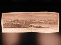
'The Naval Gazetteer' is a late 18th-century sailor's guide, filled with descriptions of coastlines, countries, and islands from around the world and sailing directions to and from various locations. However, the real draw of this set is the exquisite folding maps! Maps include views of ports and coasts along India, Portugal, the Baltic Sea, North and South America, Africa, and Great Britain.
Item number: #14295
Price: $1950
MALHAM, John
The naval gazetteer, or, Seaman's complete guide : containing a full and accurate account, alphabetically arranged, of the several coasts of all the countries and islands in the known world ...
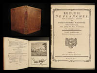
Boston : Printed for and sold by W. Spottswood and J. Nancrede, 1797. First edition.
Details:
· Collation: Complete; 2 volumes
o Vol. 1 – xlvi, 436 (i.e. 536)
10 folding maps
Wanting frontis folding map
o Vol. 2 – 573, [3]
6 folding maps
· Provenance: Handwritten
o J.L. Parrish
o M.A. Parrish
o Peter Le Breton
· Language: English
· Binding: Leather; tight & secure
· Size: ~8.5in X 5.5in (cm x cm)
· Very rare and desirable with auction records and price comparisons at $4,000
Our Guarantee:
Very Fast. Very Safe. Free Shipping Worldwide.
Customer satisfaction is our priority! Notify us with 7 days of receiving, and we will offer a full refund without reservation!
14295
Photos available upon request.
Reseñas
(¡Iniciar sesión or Crear una cuenta primero!)
Detalles
- Librería
- Schilb Antiquarian Rare Books
 (US)
(US)
- Inventario del vendedor #
- 14295
- Título
- The naval gazetteer, or, Seaman's complete guide : containing a full and accurate account, alphabetically arranged, of the several coasts of all the countries and islands in the known world
- Autor
- MALHAM, John
- Formato/Encuadernación
- Leather; tight & secure
- Estado del libro
- Usado - Near Fine
- Cantidad disponible
- 1
- Edición
- First
- Encuadernación
- Tapa dura
- Editorial
- for and sold by W. Spottswood and J. Nancrede
- Lugar de publicación
- Boston
- Fecha de publicación
- 1797
- Peso
- 0.00 libras
- Palabras clave
- 1797 1ed AMERICAN Naval Gazetteer Voyages Malham Sailing MAPS Atlas Africa Portsrare, antique, old, first edition, 1st state, provenance, signed, inscribed, dust jacket, vellum, manuscript, engravings, illustrations, leather, plates, maps, antiquarian
- Atención
- Puede que se trate de un conjunto de varios volúmenes y requiera de gastos de envío adicionales.
Términos de venta
Schilb Antiquarian Rare Books
30 day return guarantee, with full refund including original shipping costs for up to 30 days after delivery if an item arrives misdescribed or damaged.
Sobre el vendedor
Schilb Antiquarian Rare Books
Miembro de Biblio desde 2018
COLUMBIA, Missouri
Sobre Schilb Antiquarian Rare Books
We live & breathe rare books! This year we are celebrating over a decade of business with over 10,000 positive transactions all over the globe! We remain at your service and look forward to earning your business.
Glosario
Algunos términos que podrían usarse en esta descripción incluyen:
- First Edition
- In book collecting, the first edition is the earliest published form of a book. A book may have more than one first edition in...
- Tight
- Used to mean that the binding of a book has not been overly loosened by frequent use.
Preguntas frecuentes
Categorías de este libro
Also Recommended
-
-
![Antiquitatum convivialium libri III.: In quibus Hebraeorum, Graecorum, Romanorum aliarumque nationum antiqua conviviorum genera, mores, consuetudines, ritus ceremoniaeq́[ue] conviviales atque etiam alia explicantur; & cum ijs, quae hodie cúm apud Christianos, tum apud alias gentes, a Christiano nomine alienas, in usu sunt, conferuntur: multa grammatica, physica, medica, ethica, oeconomica, politica, philosophica deniq[ue] atq[ue] historica cognitu jucunda simul & utilia tractantur: plurima sacrorum prophanorumq́[ue] auctorum veterum loca obscura illustrantur, corrupta emendantur: deniq[ue] desperatus deploratusq́[ue] nostrorum temporum luxus atq[ue] luxuria gravi censura damnatur](https://d3525k1ryd2155.cloudfront.net/h/365/113/1303113365.0.m.jpg)
-
-

-

¡Ahorra un 10% en cada compra!
Únete al Biblioclub y empieza a ahorrar un 10% enn todas tus compras.
$29.95 / Año