
Ver a tamaño completo.
Le Perou Dans L'Amerique Meridionale
de FER, Nicolas de
- Usado
- Estado
- Ver descripción
- Librería
-
New York, New York, United States
Formas de pago aceptadas
Sobre este artículo
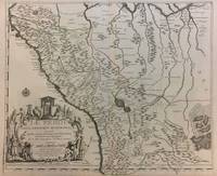
Paris, 1719. Map. Engraving with original hand outline color. Image measures 19 x 23". Sheet measures 20 x 28".<br/> <br/> Unusual map of Peru from the early 18th century. Includes part of Ecuador, Bolivia and Brazil, based on Jesuit activity in the area. Amazon rain forest is visualized with a dynamic design. Cartouche describes the mining industry. Nicolas de Fer (1646-1720) was a prolific cartographer, engraver and publisher who took over the family map business from his mother when she retired in 1687. The business flourished and he gained a great reputation in his lifetime and was appointed 'Geographer to the King' in 1690. This map demonstrates his skill and provides a curious yet alluring mixture of history and geography.<br/> <br/>
Reseñas
(¡Iniciar sesión or Crear una cuenta primero!)
Detalles
- Librería
- Argosy Book Store
 (US)
(US)
- Inventario del vendedor #
- 291534
- Título
- Le Perou Dans L'Amerique Meridionale
- Autor
- FER, Nicolas de
- Estado del libro
- Usado
- Cantidad disponible
- 1
- Lugar de publicación
- Paris
- Fecha de publicación
- 1719
- Palabras clave
- de Fer, Holy Land
Términos de venta
Argosy Book Store
All items are offered net, subject to prior sale. Returns accepted within 7 days of receipt--please contact us first. Payment by Visa , Mastercard & American Express. Appropriate sales tax will be added for all N.Y. State residents
Sobre el vendedor
Argosy Book Store
Miembro de Biblio desde 2004
New York, New York
Sobre Argosy Book Store
We are a large retail store, with 6 floors of out-of-print and rare books, (including, Americana, modern first editions, history of medicine and science), antique maps and prints, autograph manuscripts, letters & signatures.
Glosario
Algunos términos que podrían usarse en esta descripción incluyen: