Descripción:
Government Printing Office, 1911. Hardcover. Good. . Minor dampstaining to first few pages, otherwise clean. Fold-outs in back pocket, clean and intact.
The Rampart and Hot Springs Regions, Alaska - United States Geological Survey (USGS) Bulletin No. 520-I de H. M. Eakin - 1912
de H. M. Eakin

The Rampart and Hot Springs Regions, Alaska - United States Geological Survey (USGS) Bulletin No. 520-I
de H. M. Eakin
- Usado
- Tapa blanda
Washington, DC: Government Printing Office, 1912. Soft cover. VG-. 8vo - over 7¾ - 9¾" tall. See photos for condition details. Softcover, original 1912 publication with original wraps - not a modern reprint or rebound library copy. Exterior shows toning along with some light staining and soiling, larger stain is present along spine edge on rear cover. Edges and corner show bumps and the covers at the top of the spine shows a tear of about 1 inch. Internal binding is good pages are tight. Paper is toned due to age and there is some spotting/foxing present. Corner bumps that were present on the exterior are present on the interior pages as well, page 6 contains a large foldout map which is attached and in good shape.
-
Librería
Independent bookstores
 (US)
(US)
- Formato/Encuadernación Soft cover
- Estado del libro Usado - VG-
- Cantidad disponible 1
- Encuadernación Tapa blanda
- Editorial Government Printing Office
- Lugar de publicación Washington, DC
- Fecha de publicación 1912
- Páginas 20
- Tamaño 8vo - over 7¾ - 9¾
- Size 8vo - over 7¾ - 9¾" tall

A Geologic Reconnaissance in Southwestern Seward Peninsula and the Norton Bay-Nulato Region - Alaska
de Philip S. Smith ; H.M. Eakin
- Usado
- good
- Tapa dura
- Estado
- Usado - Good
- Encuadernación
- Hardcover
- Cantidad disponible
- 1
- Librería
-
Simi Valley, California, United States
- Precio
-
EUR 12.25
Mostrar detalles
Precio
EUR 12.25

Más fotos
The Cosna-Nowitna Region, Alaska
de Eakin, H. M
- Usado
- Tapa dura
- Estado
- Usado - Good+ with no dust jacket
- Edición
- First Edition
- Encuadernación
- Hardcover
- Cantidad disponible
- 1
- Librería
-
Reno, Nevada, United States
- Precio
-
EUR 21.68
Mostrar detalles
Descripción:
Washington, D. C.: U. S. Geological Survey, 1918. First Edition. Hardcover. Good+ with no dust jacket. Unmarked. Two plates are present, but folder (pocket) is brittle and has broken. Book is in otherwise verygood or better shape. Mild wear on some corners. ; Book Description; Spine has no signs of creasing. Pages are clean and not marred by notes or folds. Covers are square with minor wear. Ships Safe and Fast. Published without Dust Jacket. ; U. S. Geological Survey Bulletin; Textbook; Vol. 667; B&W Photographs; 8vo 8" - 9" tall; 54 pages.
Precio
EUR 21.68

Más fotos
The Yukon-Koyukuk Region
de Eakin, H. M
- Usado
- Tapa dura
- First
- Estado
- Usado - Good+ with no dust jacket
- Edición
- First Edition
- Encuadernación
- Hardcover
- Cantidad disponible
- 1
- Librería
-
Reno, Nevada, United States
- Precio
-
EUR 37.70
Mostrar detalles
Descripción:
Washington, D. C.: U. S. Geological Survey, 1916. First Edition. Hardcover. Good+ with no dust jacket. Unmarked. Some bumping of some corners with very mild wear. Botom corner pags have been bumped. Maps intact in back pocket. ; Book Description; Spine has no signs of creasing. Pages are clean and not marred by notes or folds. Covers are square with minor wear. Ships Safe and Fast. Published without Dust Jacket. Government Rebound original paperback edition, red boards with guild lettering on spine Guild lettering on spine. ; U. S. Geological Survey Bulletin; Vol. 631; B&W Photographs; 8vo 8" - 9" tall; 88 pages DW2.
Precio
EUR 37.70
A Geologic Reconnaissance In Southeastern Seward Penninsula And The Norton Bay-Nulato Region, Alaska.
de Smith, Philip S. and H. M. Eakin
- Usado
- very good
- Estado
- Usado - Very Good
- Cantidad disponible
- 1
- Librería
-
Princeton, New Jersey, United States
- Precio
-
EUR 42.42
Mostrar detalles
Descripción:
Washington: Government Printing Office, 1911. Department of the Interior. United States Geological Survey. Bulletin 449. 13 plates including a 3 large foldout maps in rear pocket: Reconnaissance map of southeastern Seward Peninsula; Geologic Map of Nulato-Norton Bay Region and Geologic map of southeastern Seward Peninsula. 15 illustrations (figures).146 pp including Index. Covers are Very Good. Some soiling to spine. small tear at spine base. Back cover creased at bottom edge. endpapers - mild watermark, 1/4" and diminishing by page 15. Otherwise interior is tight, clean and VG.. Paper Cover. Very Good. Illus. by Foldouts, Tables, Figures (line drawings), Foldout Map. Size: Approx. 5 3/4" x 9". Alaska.
Precio
EUR 42.42
UGSG Bulletins 575, 576, 577, 578
de Calvert, W. R.; Beekley, A. L.; Moffit, Fred H.; Richards, R. W.; Mansfield, G. R.; Eakin, Henry M
- Usado
- very good
- Tapa dura
- Estado
- Usado - Very Good
- Encuadernación
- Hardcover
- Cantidad disponible
- 1
- Librería
-
Salt Lake City, Utah, United States
- Precio
-
EUR 70.70
Mostrar detalles
Descripción:
Government Printing Office, 1914. Very Good. Calvert, W. R.. UGSG Bulletins 575, 576, 577, 578. Beekley, A. L.; Moffit, Fred H.; Richards, R. W.; Mansfield, G. R.; Eakin, Henry M.. Washington, D. C.: Government Printing Office, 1914. 49, 56, 76, 45pp. Indexed. 8vo. Hardcover. Book condition: Very good. Light rubbing to extremities. Former owner's name stamped on front end sheet. Contains Standing Rock and Cheyenne River Indian Reservations, Hanagita-Bremner Region Alaska, Phosphate Deposits Northeast of Georgetown, Idaho, and The Iditrod-Ruby Region, Alaska.
Precio
EUR 70.70
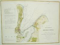
The Harbor of Holmes' Hole
de C.M. Eakin; H.L. Whiting; G.S. Blake; A.D. Bache
- Usado
- Estado
- Usado - Very Good; left margin extended.
- Cantidad disponible
- 1
- Librería
-
Toronto, Ontario, Canada
- Precio
-
EUR 353.48
Mostrar detalles
Descripción:
United States: U.S. Coast Survey, 1847. Very Good; left margin extended.. Notes: Holmes' Hole is now known as Vineyard Haven., Size : 263x358 (mm), 10.35x14.09 (Inches), Coloring: Hand Colored, Category: Maps United States New England (States);
Precio
EUR 353.48
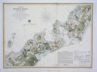
The Harbor of Wood's Hole Massachusetts
de C. M. Eakin, W.M. Boyce, G.S. Blake, C.H. Davis, M. Woodhull
- Usado
- Estado
- Usado - Very Good, the upper fold has been reinforced
- Cantidad disponible
- 1
- Librería
-
Toronto, Ontario, Canada
- Precio
-
EUR 542.00
Mostrar detalles
Descripción:
New York, 1857. Very Good, the upper fold has been reinforced. Size : 321x444 (mm), 12.625x17.5 (Inches), Coloring: Hand Colored, Category: Maps Sea Chart; Maps United States New England (States);
Precio
EUR 542.00

Preliminary Chart of Muskeget Channel Massachusetts
de C.M. Eakin, H.I. Whiting
- Usado
- very good
- Estado
- Usado - Very Good
- Cantidad disponible
- 1
- Librería
-
Toronto, Ontario, Canada
- Precio
-
EUR 706.95
Mostrar detalles
Descripción:
USA: US Coast Survey, 1855. Very Good. Notes: A scarce 19th centruy sea chart of Martha's Vineyard and vicinity., Size : 705x510 (mm), 27.75x20.125 (Inches), Coloring: Hand Colored, Category: Maps Sea Chart; Maps United States New England (States);
Precio
EUR 706.95