Descripción:
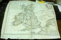
Colomb, Jacob Aertsz. De Custe van Engelant tußchen Poortlant en Lezard. Additional title: Les Costes d'Angleter re de Fierleij jusques á Lezard. Ca 1640. Listed in the The New Fierie Sea-Colomne from 1633-1651. Copper engraved, early hand coloured chart. Chart size approx 525mm x 375mm. Orientation NNE top centre cartouche contains scale. Decorative title cartouche to upper right and additional title cartouche below scales. Chart covers land areas from Portland to the Lizard. Among the places indicated on the coast line are Bridport, Torbay, Dartmouth, Plymouth, Fowey and Truro. Decorative compass rose, rhumb lines and sea vessel on sea area, which also includes the Ideston [Eddystone] Rock and the Kasquettes [Casquets] . Side margins tight with small breaks just touching edge of engraved area. One tear in sea area, repaired. Very early handwritten note to top margin, commenting on the soundings of this area and that of Falmouth, suggesting this chart had been used as a working reference at…
Leer más A Representation of the Solar System with the Comparative Sizes of the Planets de Salmon, Thomas - 1772
de Salmon, Thomas

A Representation of the Solar System with the Comparative Sizes of the Planets
de Salmon, Thomas
- Usado
"A Representation of the Solar System with the comparative Sizes of the Planets" by Thomas Salmon c1772. 250 x 170 mm. From the 12th Edition of "A new geological and historical grammar..." published in London 1772.
This is a very nice 18th century astronomy illustration suitable for display. Some minor foxing and light discoloration along the edges. Illustrations and text are clear and legible. Intact. Excellent copy of this illustration of the contemporary understanding of the Solar System at that time.
-
Librería
Independent bookstores
 (US)
(US)
- Estado del libro Usado
- Cantidad disponible 1
- Lugar de publicación London
- Fecha de publicación 1772
- Size 250mm x 170mm

Sea Chart Portland to the Lizard. De Custe van Engelant tußchen Poortlant en Lezard [Sea Chart Portland to the Lizard]. Jacob Aertsz Colomb. Ca1640: Sea Chart Portland to the Lizard.
de Jacob Aertsz Colomb
- Usado
- Estado
- Usado
- Cantidad disponible
- 1
- Librería
-
Plymouth, Devon, United Kingdom
- Precio
-
EUR 213.84
Mostrar detalles
Precio
EUR 213.84

Más fotos
A New and Accurate Description of All the Direct and Principal Cross Roads in England and Wales [bound with] A travelling dictionary: or, alphabetical tables of the distance of all the principal cities, borough, market, and sea-port towns, in Great Britain, from each other. Shewing by Inspection The Number of Miles every City or Town in the Kingdom is Distant from any other, according to the nearest Direct or Cross Road. Comprehending Above Fifty Thousand Distances, carefully collected from the best Authorities, and arranged in a Manner entirely new and plain. To which is Added, A Table, shewing the Distance of the Towns, Bridges, &c. upon the River Thames, from each other by Water. The whole being a second part to the New and accurate description of the roads
de PATERSON, Daniel (1738-1825)
- Usado
- Aceptable
- Estado
- Usado - Aceptable
- Edición
- Early Reprint
- Encuadernación
- Unknown
- Cantidad disponible
- 1
- Librería
-
Lancaster, Pennsylvania, United States
- Precio
-
EUR 269.98
Mostrar detalles
Descripción:
London: printed for T. N. Longman, Pater-Noster-Row [from 1771], 1794. Early Reprint. Stiff Wraps. Fine. 8vo: xxxvi,380 numbered columns,381-394pp, with double-page copper-engraved map as frontispiece; [4],216pp. ESTC Citation No. T93564 and T93553. Finely bound to style by Fitterer in stiff beige wraps, printed paper spine label. Binding and text block clean, bright and unmarked save for offsetting from engraved map. A superlative copy. Fordham (Road-Books), pp. 27 and 29. Roscoe, (John Newbery) A399/6. Not in Hodson. The tenth edition: with the addition of near ninety pages, including considerable improvements in the direct roads, many new cross roads, and a great number of noblemen's and gentlemen's seats. Tenth Edition of the first work (1794; originally published 1771) "With the Addition of near Ninety Pages, including considerable Improvements in the direct Roads, many new Cross Roads, and a great Number of Noblemen's and Gentlemen's Seats"; Sixth Edition (1792), improved and corrected, of the…
Leer más Precio
EUR 269.98
![Blatt 8 (VIII) : Aarau - Luzern Zug - Zürich [Zurich] : Topographische Karte der Schweiz :...](https://d3525k1ryd2155.cloudfront.net/h/777/796/330796777.0.m.jpg)
Más fotos
Blatt 8 (VIII) : Aarau - Luzern Zug - Zürich [Zurich] : Topographische Karte der Schweiz : Massstab 1 : 100,000, Vermessen und herausgegeben unter Aufsicht von General G. H. Dufour
de Dufour, General G. H. [Guillaume-Henri]
- Usado
- Tapa dura
- Estado
- Usado - Very Good (somewhat spotted)
- Edición
- 1861 edition
- Encuadernación
- Hardcover
- Cantidad disponible
- 1
- Librería
-
Henderson, Nevada, United States
- Precio
-
EUR 163.48
Mostrar detalles
Descripción:
Bern [Switzerland]: Hans Körber [Koerber] (Huber & Comp.), 1861. Very Good condition. SEE PHOTOS. Karten etwas fleckig (maps somewhat spotted). This is Blatt VIII, Aarau - Luzern Zug - Zürich [Zurich]. The map is dated 1861 and has 21 sections. It is printed on paper, then mounted on cloth (i.e. backed with linen). When folded the map measures 19 cm tall x 11 cm wide. When unfolded, 57 cm tall x 79 cm wide. SEE PHOTOS. Linen-backed, steel-engraved folding map in 21 segments. Scale 1:100,000.. 1861 edition. Hardcover. Very Good (somewhat spotted).
Precio
EUR 163.48

Más fotos
Arab navigation in the Indian Ocean before the coming of the Portuguese
de Ahmad ibn Majid al-Sadi , G.R. Tibbetts
- Usado
- Tapa dura
- First
- Estado
- Nuevo
- Edición
- First Edition
- Encuadernación
- Hardcover
- ISBN 10 / ISBN 13
- 9780718909000 / 0718909003
- Cantidad disponible
- 1
- Librería
-
Berg en dal, Netherlands
- Precio
-
EUR 240.00
Mostrar detalles
Descripción:
Ahmad ibn Majid al-Sadi, G.R. Tibbetts - Arab Navigation in the Indian Ocean before the coming of the Portuguese - London, The Royal Asiatic Society of Great Britain and Ireland; Luzac and Company Ltd, 1971 - First Edition - Hardcover - 614pp + 4 maps (out of 7)- 22x14 cmCondition Very Good: Cover some light shelf wear, inside as new. Four out of seven maps present: Chart of the Arabian Sea, India and the Bay of Bengal, Red Sea and Gulf of Eden, East African CoastIf you have any questions or want to see more pictures, feel free to ask.Your book will be securely packed and shipped with tracking number, signed & insured.
Precio
EUR 240.00

Más fotos
1875 ILLINOIS CENTRAL MAP.: Map of the Illinois Central Railroad and its Connections.
- Usado
- Estado
- Usado
- Cantidad disponible
- 1
- Librería
-
Houston, Texas, United States
- Precio
-
EUR 275.59
Mostrar detalles
Descripción:
[Railroad] Map of the Illinois Central Railroad and its Connections. Chicago: Rand McNally and Company Map Engravers. 1875. Map printed on green paper. 33 x 25 on sheet 40 x 38 cm folded to 9 x 19 cm. Added text printed in green in margins around map. One three inch fold split, else very good.OCLC shows one holding (Newberry Lib.) Relief shown by hachures. Timetables on verso "corrected to June 20th, 1875." Text describing routes and connections on 5 panels on verso: Illinois Central Railroad principal connections -- Illinois Central Railroad Dubuque and Sioux City Line! -- Illinois Central Railroad, the direct route from Chicago to Springfield, Farmer City, Clinton and Mt. Pulaski -- Illinois Central Railroad St. Louis through line -- Illinois Central Railroad New Orleans through line.
Precio
EUR 275.59
Nuova Carta dell' Isole Britanniche divise nei tre Regni d'Inghilterra, di Scozia, e d'Irlanda by [L'Isle (Guillaume de)]
de [L'Isle (Guillaume de)]
- Usado
- Muy bueno
- Estado
- Usado - Muy bueno
- Encuadernación
- Unknown
- Cantidad disponible
- 1
- Librería
-
Binghamton, New York, United States
- Precio
-
EUR 191.51
Mostrar detalles
Descripción:
Albrizzi, 1743, Venice. Very Good. Prompt shipment, with tracking. we ship in CLEAN SECURE NEW boxes Full margins, uncolored, slight tearing to edges, folded with some repair to two folds. Very good. *
Precio
EUR 191.51

Más fotos
Hydraulics of Great Rivers, the Parana, the Uruguay and the la Plata Estuary
de J.J. Révy
- Usado
- Bien
- Tapa dura
- First
- Estado
- Usado - Bien
- Estado de la sobrecubierta
- No Jacket
- Edición
- First Edition
- Encuadernación
- Hardcover
- Cantidad disponible
- 1
- Librería
-
Harleston, Norfolk, United Kingdom
- Precio
-
EUR 178.20
Mostrar detalles
Descripción:
London: E.and F.N. Spon, 1874. First Edition. Hardback. Good/No Jacket. 2339 Folio. With charts and tables, all as called for. In original black cloth-covered boards, blind stamped, gilt titles. An account of the surveying of three of the largest rivers in the world, undertaken under considerable pressure of time, to enable proposed engineering works. The work included development of an improved current meter, based on one that was just being offered to market as the expedition was being planned. Of the device offered to him, which had been simplified from a sound design in order to make it "easier" to use, the author wrote "all these attempts at making things very easy is a mistake, for they tend to make things very useless" - a sentiment which is likely to ring true for many of us today. Condition notes: Boards bumped and rubbed, title page just starting to pull away from its binding, and some foxing to the prelims. Apart from the early foxing, the pages are clean and…
Leer más Precio
EUR 178.20

Más fotos
Digging the Old West: How Dams and Ditches Sculpted an American Landscape
de Franklin, Karmen Lee
- Usado
- Tapa blanda
- Estado
- Used- Fine
- Encuadernación
- Paperback
- ISBN 10 / ISBN 13
- 9780615531489 / 0615531482
- Cantidad disponible
- 1
- Librería
-
Longmont, Colorado, United States
- Precio
-
EUR 256.91
Mostrar detalles
Descripción:
Franklin Design Bureau, 2011. Paperback. Used- Fine condition. Book is clean and tight. Book shows light shelf wear. Light bumping on the top and bottom of the spine. No markings on the inside of the book. Photos are of the book we have here at Barbed Wire Books."It is one of the few works that attempts fully to explain Colorado's water history. It is unusually well-written, with vivid descriptions of people, processes, events, and landscape features." Mark Fiege
Precio
EUR 256.91
Más fotos
ATLAS DE GÉOGRAPHIE
de GAULTIER, L'Abbé (Aloisius Edouard Camille) (1746-1818)
- Usado
- Tapa dura
- Estado
- Usado - Bom / Good / Bon
- Encuadernación
- Hardcover
- Cantidad disponible
- 1
- Librería
-
Cascais, Portugal
- Precio
-
EUR 250.00
Mostrar detalles
Descripción:
Paris: Librairie Classique et D'Éducation. Editorial / Hard Cover. Bom / Good / Bon. In-fólio (435x286). 1 Vol. de 21 fls. Contém 15 cartas coloridas de dupla página em muito bom estado e com cartonagem editorial.
Precio
EUR 250.00
Más fotos
Notes on Peking and Its Neighbourhood (Bound Offprint from The Journal of the Royal Geographical Society of London, Vol. 36 (1866))
de Lockhart, W.
- Usado
- Muy bueno
- Tapa dura
- First
- Estado
- Usado - Muy bueno
- Estado de la sobrecubierta
- No Jacket, As Issued
- Edición
- First Printing
- Encuadernación
- Hardcover
- Cantidad disponible
- 1
- Librería
-
Bloomington, Indiana, United States
- Precio
-
EUR 186.84
Mostrar detalles
Descripción:
London: J. Murray / The Journal of the Royal Geographical Society of London, 1866. SCARCE pp. 128-156 (33 pages) with fold-out map - "The City of Peking from a Survey by Capt. Bouvier , of the French Engineers 1862" , . The map is Near Fine, 1" tear at right edge. In original dark blue cloth boards, gilt lettering at spine, Very Good, the boards stained and soiled, toning at end papers, German bookseller's small ticket and prior owner name front paste down. . First Printing. Cloth. Very Good/No Jacket, As Issued. 8vo - over 7¾" - 9¾" tall.
Precio
EUR 186.84

Foto de archivo: la portada puede ser diferente
How to Build a Beowulf: A Guide to the Implementation and Application of PC Clusters (Scientific and Engineering Computation)
de Savarese, Daniel F.; Becker, Donald J.; Salmon, John; Sterling, Thomas
- Usado
- Bien
- Tapa blanda
- Estado
- Usado - Bien
- Encuadernación
- Paperback
- ISBN 10 / ISBN 13
- 9780262692182 / 026269218X
- Cantidad disponible
- 1
- Librería
-
Memphis, Tennessee, United States
- Precio
-
EUR 5.11
Mostrar detalles
Descripción:
MIT Press, 1999-05-28. Paperback. Good. 9x7x0.
Precio
EUR 5.11

How to Build a Beowulf : A Guide to the Implementation and Application of PC Clusters
de Donald J. Becker; William Gropp; Daniel F. Savarese; Thomas L. Sterling; John Salmon
- Usado
- Bien
- Tapa blanda
- Estado
- Usado - Bien
- Encuadernación
- Paperback
- ISBN 10 / ISBN 13
- 9780262692182 / 026269218X
- Cantidad disponible
- 2
- Librería
-
Seattle, Washington, United States
- Precio
-
EUR 5.60
Mostrar detalles
Descripción:
MIT Press, 1999. Paperback. Good. Pages can have notes/highlighting. Spine may show signs of wear. ~ ThriftBooks: Read More, Spend Less.Dust jacket quality is not guaranteed.
Precio
EUR 5.60
Foto de archivo: la portada puede ser diferente
How to Build a Beowulf : A Guide to the Implementation and Application of PC Clusters
de Donald J. Becker; Daniel F. Savarese; Thomas L. Sterling; John Salmon
- Usado
- Aceptable
- Tapa blanda
- Estado
- Usado - Aceptable
- Encuadernación
- Paperback
- ISBN 10 / ISBN 13
- 9780262692182 / 026269218X
- Cantidad disponible
- 1
- Librería
-
Seattle, Washington, United States
- Precio
-
EUR 5.60
Mostrar detalles
Descripción:
MIT Press, 1999. Paperback. Acceptable. Disclaimer:A readable copy. All pages are intact, and the cover is intact. Pages can include considerable notes-in pen or highlighter-but the notes cannot obscure the text.
Precio
EUR 5.60
Foto de archivo: la portada puede ser diferente
How to Build a Beowulf: A Guide to the Implementation and Application of PC Clusters (Scientific and Engineering Computation)
de Savarese, Daniel F.,Becker, Donald J.,Salmon, John,Sterling, Thomas
- Usado
- Muy bueno
- Tapa blanda
- Estado
- Usado - Muy bueno
- Encuadernación
- Paperback
- ISBN 10 / ISBN 13
- 9780262692182 / 026269218x
- Cantidad disponible
- 1
- Librería
-
Simi Valley, California, United States
- Precio
-
EUR 1.87
Mostrar detalles
Descripción:
The MIT Press, 5/28/1999 12:00:01 A. paperback. Very Good. 0.7000 8.9000 7.9000.
Precio
EUR 1.87
Foto de archivo: la portada puede ser diferente
How to Build a Beowulf : A Guide to the Implementation and Application of PC Clusters
de Salmon, John, Gropp, William, Savarese, Daniel F., Sterling, Thomas L., Becker, Donald J
- Usado
- Estado
- Used - Very Good
- ISBN 10 / ISBN 13
- 9780262692182 / 026269218x
- Cantidad disponible
- 1
- Librería
-
Mishawaka, Indiana, United States
- Precio
-
EUR 6.43
Mostrar detalles
Descripción:
MIT Press. Used - Very Good. Former library book; may include library markings. Used book that is in excellent condition. May show signs of wear or have minor defects.
Precio
EUR 6.43
Foto de archivo: la portada puede ser diferente
How to Build a Beowulf : A Guide to the Implementation and Application of PC Clusters
de Salmon, John, Gropp, William, Savarese, Daniel F., Sterling, Thomas L., Becker, Donald J
- Usado
- Estado
- Used - Good
- ISBN 10 / ISBN 13
- 9780262692182 / 026269218x
- Cantidad disponible
- 1
- Librería
-
Mishawaka, Indiana, United States
- Precio
-
EUR 6.43
Mostrar detalles
Descripción:
MIT Press. Used - Good. Used book that is in clean, average condition without any missing pages.
Precio
EUR 6.43
Foto de archivo: la portada puede ser diferente
How to Build a Beowulf : A Guide to the Implementation and Application of PC Clusters
de Salmon, John, Gropp, William, Savarese, Daniel F., Sterling, Thomas L., Becker, Donald J
- Usado
- Estado
- Used - Very Good
- ISBN 10 / ISBN 13
- 9780262692182 / 026269218x
- Cantidad disponible
- 1
- Librería
-
Mishawaka, Indiana, United States
- Precio
-
EUR 6.43
Mostrar detalles
Descripción:
MIT Press. Used - Very Good. Used book that is in excellent condition. May show signs of wear or have minor defects.
Precio
EUR 6.43
Foto de archivo: la portada puede ser diferente
How to Build a Beowulf: A Guide to the Implementation and Application of PC Clusters (Scientific and Engineering Computation)
de Thomas Sterling; Daniel F. Savarese; Donald J. Becker; John Salmon
- Usado
- Tapa blanda
- Estado
- Used: Good
- Encuadernación
- Paperback
- ISBN 10 / ISBN 13
- 9780262692182 / 026269218X
- Cantidad disponible
- 1
- Librería
-
HOUSTON, Texas, United States
- Precio
-
EUR 6.99
Mostrar detalles
Descripción:
The MIT Press, 1999-05-28. Paperback. Used: Good.
Precio
EUR 6.99
Foto de archivo: la portada puede ser diferente
How to Build a Beowulf: A Guide to the Implementation and Application of PC Clusters (Scientific and Engineering Computation)
de Savarese, Daniel F., Becker, Donald J., Salmon, John, Sterling, Thomas
- Usado
- Estado
- Used - Good
- ISBN 10 / ISBN 13
- 9780262692182 / 026269218x
- Cantidad disponible
- 1
- Librería
-
Frederick, Maryland, United States
- Precio
-
EUR 5.04
Mostrar detalles
Descripción:
The MIT Press. Used - Good. Good condition. A copy that has been read but remains intact. May contain markings such as bookplates, stamps, limited notes and highlighting, or a few light stains.
Precio
EUR 5.04

Hajar Bin Humeid: Investigations at a Pre-Islamic Site in South Arabia
de Van Beek, Gus W. ; Jamme, Albert ; Salmon, Maurice E. ; Al Kital, Rahim A. ; Chan, Lui-Heung ; Sayre, Edward V. ; Soderstrom, Thomas R. ; Melson, William G. Phillips, Wendell
- Usado
- Aceptable
- Tapa dura
- Estado
- Usado - Aceptable
- Estado de la sobrecubierta
- near fine
- Encuadernación
- Hardcover
- Cantidad disponible
- 1
- Librería
-
Pittsburgh, Pennsylvania, United States
- Precio
-
EUR 8.59
Mostrar detalles
Descripción:
Baltimore, Maryland: Johns Hopkins Press, 1969. Hardcover. Fine/near fine. 1969, Edition not stated, likely the First Edition. Hardcover, an Imperial Octavo (8.5 x 11.10 inches ), in Very Good condition, with abrasions at two corners. PAGES: 421. Illustrated throughout with plan views of excavations, detailed drawings of artifacts, and numerous black and white excavation photographs.
Precio
EUR 8.59

Más fotos
The Sky and the Forest
de Forester, C.S
- Usado
- Muy bueno
- Tapa dura
- First
- Estado
- Usado - Muy bueno
- Estado de la sobrecubierta
- Very Good
- Edición
- First Edition
- Encuadernación
- Hardcover
- Cantidad disponible
- 1
- Librería
-
Salem, Oregon, United States
- Precio
-
EUR 32.59EUR 16.30¡Ahorra EUR 17.44!
Mostrar detalles
Descripción:
C.S. Forester: The Sky and the Forest. Little, Brown and Company, Boston. Stated First Edition First Printing Thus August, 1948. Cover price $2.75. Used. VG BOOK/VG UNCLIPPED DUST JACKET. A story of a central Africa. By C.S. Forester, author of the Admiral Hornblower series.
Precio
EUR 32.59EUR 16.30
¡Ahorra EUR 17.44
!

Más fotos
Plat Book: Pierce County, Wisconsin
de Rhame, A. E
- Usado
- Aceptable
- Tapa blanda
- Estado
- Usado - Aceptable
- Encuadernación
- Paperback
- Cantidad disponible
- 1
- Librería
-
Woodruff, Wisconsin, United States
- Precio
-
EUR 43.59
Mostrar detalles
Descripción:
1930. Soft Cover. Fine. Unpaginated. Tan colored book is in Fine condition, no sign of wear.
Precio
EUR 43.59
![Alaska and Klondike Region; [With inset of Klondike Region on the Upper Yukon detail] [From an...](https://d3525k1ryd2155.cloudfront.net/h/062/537/1339537062.0.m.jpg)
Alaska and Klondike Region; [With inset of Klondike Region on the Upper Yukon detail] [From an atlas, "Gazetteer of Alaska and Yukon Region " pp. 105 and 106]
de Miller, J. Martin
- Usado
- Muy bueno
- Estado
- Usado - Muy bueno
- Edición
- Unknown
- Cantidad disponible
- 1
- Librería
-
Sebastopol, California, United States
- Precio
-
EUR 36.43
Mostrar detalles
Descripción:
Chicago: J. Martin Miller, 1899. Unknown. Map. Very Good. [Map copyright 1899, printing date of Atlas later] [19.875x15.125in]; Colored map of Alaska with steamer routes from Portland and Seattle, insets of the Klondike Region on the Upper Yukon and Western portion of Aleutian Islands; On verso index of places and names with two large black and white images; Age toning to all edges, water stain marks on bottom, slight printing offset of colors, small chips and closed tears to lower edge;.
Precio
EUR 36.43

Zemepis Sveta - Monsunova Asie
de De La Blache, P. Vidal; Gallois, L
- Usado
- Tapa dura
- Estado
- Usado - Very Good Condition
- Estado de la sobrecubierta
- No Dust Jacket
- Encuadernación
- Hardcover
- Cantidad disponible
- 1
- Librería
-
Oak Point, Texas, United States
- Precio
-
EUR 56.05
Mostrar detalles
Descripción:
Aventinum, Prague, Czechoslovakia, 1930. Hardcover. Very Good Condition/No Dust Jacket. Text entirely in Czech. Geography book on Asia with numerous photographs and maps. 1931 edition also available. Size: 4mo - over 9 3/4" - 12" tall. 400 pp. Pages are yellowed, but are tight and clean. Moderate shelfwear along the spine. Corners are lightly bumped. Quantity Available: 1. Shipped Weight: 3-5 pounds. Category: Travel & Places; Non-English Language::Czech; Pictures of this item not already displayed here available upon request. Inventory No: 001227. . Additional shipping charges may apply.
Precio
EUR 56.05

Zemepis Sveta - Monsunova Asie
de De La Blache, P. Vidal; Gallois, L
- Usado
- Tapa dura
- Estado
- Usado - Very Good Condition
- Estado de la sobrecubierta
- No Dust Jacket
- Encuadernación
- Hardcover
- Cantidad disponible
- 1
- Librería
-
Oak Point, Texas, United States
- Precio
-
EUR 56.05
Mostrar detalles
Descripción:
Aventinum, Prague, Czechoslovakia, 1931. Hardcover. Very Good Condition/No Dust Jacket. Text entirely in Czech. Geography book on Asia with numerous photographs and maps. 1930 edition also available. Size: 4mo - over 9 3/4" - 12" tall. 400 pp. Pages are yellowed, but are tight and clean. Moderate shelfwear along the spine. Corners are lightly bumped. Quantity Available: 1. Shipped Weight: 3-5 pounds. Category: Travel & Places; Non-English Language::Czech; Pictures of this item not already displayed here available upon request. Inventory No: 001228. . Additional shipping charges may apply.
Precio
EUR 56.05

Last Tales
de Dinesen, Isak
- Usado
- Muy bueno
- Tapa dura
- First
- Estado
- Usado - Muy bueno
- Estado de la sobrecubierta
- Good+
- Edición
- First Edition
- Encuadernación
- Hardcover
- Cantidad disponible
- 1
- Librería
-
Salem, Oregon, United States
- Precio
-
EUR 112.10EUR 56.05¡Ahorra EUR 60.00!
Mostrar detalles
Descripción:
Dinesen, Isak: Last Tales, A Collection of Twelve New Tales of Compelling Beauty 1957, Random House. First Edition. Stated First Printing Thus. Used. Very Good/Good+ original red dust jacket, price-clipped. Jacket states 11/57 on front flap. 5 3/4 X
Precio
EUR 112.10EUR 56.05
¡Ahorra EUR 60.00
!

The Adventure of Wrangel Island
de Vilhjalmur Stefansson
- Usado
- Bien
- Tapa dura
- First
- Estado
- Usado - Bien
- Estado de la sobrecubierta
- No DJ Included
- Edición
- First Edition
- Encuadernación
- Hardcover
- Cantidad disponible
- 1
- Librería
-
Salem, Oregon, United States
- Precio
-
EUR 116.67EUR 58.34¡Ahorra EUR 62.44!
Mostrar detalles
Descripción:
The Adventure of Wrangel Island, Alaska (1925 Macmillan 1st Edition) HISTORY OF ALASKA. EXLIB. Good Condition/ No DJ included. Fold-out map affixed to binding at the back of the book has never been opened. The story of the (unsuccessful) attempted colonization of Wrangel Island Alaska. 413 pages plus appendix, Index. Titling is still bright. A clean, solid copy. Scarce.
Precio
EUR 116.67EUR 58.34
¡Ahorra EUR 62.44
!

Seven Pillars Of Wisdom, A Triumph
de Lawrence, T.E
- Usado
- Bien
- Tapa dura
- First
- Estado
- Usado - Bien
- Estado de la sobrecubierta
- No DJ Included
- Edición
- First American Edition
- Encuadernación
- Hardcover
- Cantidad disponible
- 1
- Librería
-
Salem, Oregon, United States
- Precio
-
EUR 116.73EUR 58.37¡Ahorra EUR 62.47!
Mostrar detalles
Descripción:
T.E. Lawrence. SEVEN PILLARS OF WISDOM, A TRIUMPH. AUTOBIOGRAPHY. Privately Printed, 1926. First Published for general circulation 1935. First American Edition. States MCMXXXVI on the title page. Doubleday, Doran & Company, Inc. Garden City, NY. GOOD CONDITION/ NO DUST JACKET IS INCLUDED. 672 pages, indexed. Beige buckram boards. Spine has darkened a bit. 6 7/8 X 9 ½.
Precio
EUR 116.73EUR 58.37
¡Ahorra EUR 62.47
!

North America from the Best Authorities, Russell, ca.1800
de Russell
- Usado
- Estado
- Usado
- Cantidad disponible
- 1
- Librería
-
Plymouth, Devon, United Kingdom
- Precio
-
EUR 23.76
Mostrar detalles
Descripción:
Russell, J. : A General Map of North America from the Best Authorities. Nd but ca.1800. From "A New Geographical, Historical and Commercial Grammar and Present State of Several Kingdoms of the World." Copper engraving. Size approx 200 x 230mm. Two neat folds. Some age colouring to edges, otherwise very clean and bright.
Precio
EUR 23.76

Asia from the Best Authorities, Russell, ca.1800
de Russell
- Usado
- Estado
- Usado
- Cantidad disponible
- 1
- Librería
-
Plymouth, Devon, United Kingdom
- Precio
-
EUR 23.76
Mostrar detalles
Descripción:
Russell, J. : Asia from the Best Authorities. Nd but ca.1800. From "A New Geographical, Historical and Commercial Grammar and Present State of Several Kingdoms of the World". Copper engraving. Size approx 200 x 230mm. Two neat folds. Some age colouring to edges, otherwise clean and bright. Includes Arabia, India, Borneo, Japan, China and eastern Russia.
Precio
EUR 23.76