
Ver a tamaño completo.
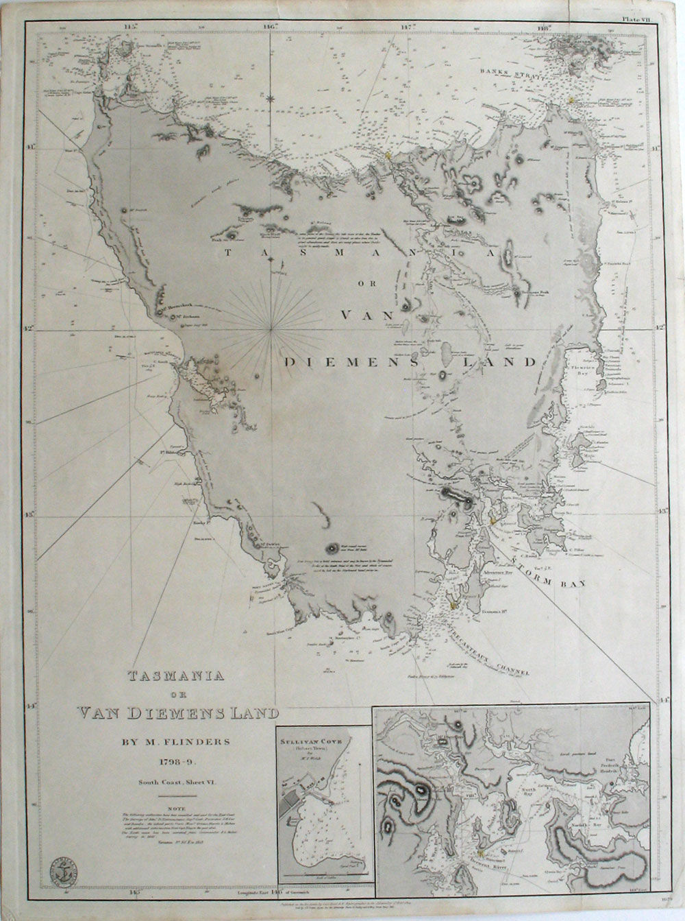
Tasmania or Van Diemens Land by M. Flinders 1798-9. South Coast, Sheet VI
de Flinders, M. (Matthew)
- Usado
- Estado
- Ver descripción
- Librería
-
Garrison, New York, United States
Formas de pago aceptadas
Sobre este artículo
London: British Admiralty Hydrographical Office, 1860. Maps. Map of Tasmania based on Matthew Flinder's chart. In 1798, Flinders and George Bass set out in the 'Norfolk' to explore the extent of the strait between the mainland and Van Diemen's Land [Tasmania]. By circumnavigating Van Diemen's Land, Flinders proved that it was a separate island. This Admiralty chart of Tasmania includes Hunter, Three Hummock Island and most of Barren Island, with insets of Sullivan Cove (Hobart Town) by Mr. I Welsh and an untitled inset of the approaches to Hobart, including depth soundings.
Plate VII outside of top right rule line, no. 1079 below bottom right rule. Tooley p. 319, #226 & also Tooley 597. Libraries Australia ID 21991504. This edition updated to 1859. Map washed in gray, lighthouses noted in yellow with red dots. Platemark 18 3/4 x 26". Small but adequate margins, with one small closed repaired tear. Very good condition.
The "Note" reads "The following authorities have been consulted and used for the East Coast. The Surveys of Adm. D.'Entrecasteaux, Capts Cook, Furneaux, J. H. Cox and Baudin; the inland parts from Messrs Grimes, Harris & Mehan with additional information from Capt. King to the year 1815. The North coast has been corrected from Commander J. L. Stokes' Survey in 1843. Variation 9 degrees 30' E. in 1859." Below the bottom rule line; "Published as the Act directs by Capt. Hurd, R.N. Hydrographer to the Admiralty : Sold by J.D. Potter, Agent for the Admiralty Charts, 31 Poultry and 11 King Street Tower Hill, 1814 Feb. 4."
Reseñas
(¡Iniciar sesión or Crear una cuenta primero!)
Detalles
- Librería
- Antipodean Books, Maps & Prints
 (US)
(US)
- Inventario del vendedor #
- 21446
- Título
- Tasmania or Van Diemens Land by M. Flinders 1798-9. South Coast, Sheet VI
- Autor
- Flinders, M. (Matthew)
- Formato/Encuadernación
- Maps
- Estado del libro
- Usado
- Cantidad disponible
- 1
- Editorial
- British Admiralty Hydrographical Office
- Lugar de publicación
- London
- Fecha de publicación
- 1860
- Catálogos del vendedor
- MAPS;
Términos de venta
Antipodean Books, Maps & Prints
30 day return guarantee, with full refund including shipping costs for up to 10 days after delivery if an item arrives mis-described or damaged.
Sobre el vendedor
Antipodean Books, Maps & Prints
Miembro de Biblio desde 2009
Garrison, New York
Sobre Antipodean Books, Maps & Prints
Booksellers for over 40 years, members of prominent trade associations (ABAA, ILAB, ANZAAB, IMCOS, ANZMS, PBFA). We are located at Garrison NY, a stone's throw from the Metro North Hudson line train, just over 1 hr. from NYC on the banks of the Hudson River. Books, maps, prints & ephemera bought & sold.
Glosario
Algunos términos que podrían usarse en esta descripción incluyen:
- Plate
- Full page illustration or photograph. Plates are printed separately from the text of the book, and bound in at production. I.e.,...