Descripción:
John Bartholomew & Son Ltd., 1977. Paperback. Good. 1977. No Edition Remarks. Unpaginated. Pictorial paper cover with colour illustrated map of Oban and Mull. Scale 1:100,000. Series 47. Map is lightly tanned to edges, with minimal thumb marking and some light scuffing to folds. Paper cover has mild edge-wear with some mild creasing. Small tears to edges. Light sunning to spine and edges.
Zetland - Bartholomew's Revised "Half-Inch" Contoured Maps, Great Britain Sheet 62 de John Bartholomew & Son Ltd - 1950
de John Bartholomew & Son Ltd

Zetland - Bartholomew's Revised "Half-Inch" Contoured Maps, Great Britain Sheet 62
de John Bartholomew & Son Ltd
- Usado
- Tapa blanda
John Bartholomew & Son Ltd, Edinburgh, 1950. Revised Edition. Softcover. Very Good Condition/No Dust Jacket. Single sheet folded paper map and has blue card covers. Sheet is folded as for original sale. Scale 1:126,720 or Half-Inch to Mile. Map is coloured according to contour and main roads are shown in red. Rivers, railways, canals, etc. are clearly indicated. A and B road numbers are given. County boundaries and Overhead Electrical Power Lines also shown. Covers are a little worn. Sheet is slightly worn, darkened and rubbed around the edges and folds. Area covered includes; Mainland, Yell, Unst, Foula, Fair Isle, Bressay, Papa Stour, Whalsey, St. Magnus Bay, Fetlar, Out Skerries, Lerwick. Size: 92x58cm. Undated by publisher. Single sheet map/chart which is suitable for framing. Estimated date only. Quantity Available: 1. Shipped Weight: under 1 kg. Pictures of this item not already displayed here available upon request. Inventory No: 45119093054. For international tracking please select Priority shipping service..
-
Librería
Bailgate Books Ltd
 (GB)
(GB)
- Formato/Encuadernación Softcover
- Estado del libro Usado - Very Good Condition
- Estado de la sobrecubierta No Dust Jacket
- Cantidad disponible 1
- Edición Revised Edition
- Encuadernación Tapa blanda
- Editorial John Bartholomew & Son Ltd
- Lugar de publicación Edinburgh
- Fecha de publicación 1950
- Palabras clave BZDB4 Maps; Scotland. John Bartholomew & Son Ltd. Zetland - Bartholomew's Revised "Half-Inch" Contoured Maps, Great Britain Sheet 62

Half Inch Map Series 47; Oban & Mull
de John Bartholomew & Son Ltd
- Usado
- good
- Tapa blanda
- Estado
- Usado - Good
- Encuadernación
- Paperback
- Cantidad disponible
- 1
- Librería
-
Goring-by-Sea, West Sussex, United Kingdom
- Precio
-
EUR 3.98
Mostrar detalles
Precio
EUR 3.98

Postal history map of Britain
de Bartholomew (John) and Son, ltd
- Usado
- very good
- Estado
- Usado - Very Good
- ISBN 10 / ISBN 13
- 9780851525402 / 0851525407
- Cantidad disponible
- 1
- Librería
-
Moorpark, California, United States
- Precio
-
EUR 11.78
Mostrar detalles
Descripción:
HarperCollins Distribution Services, 1970-01-01. Map. Very Good.
Precio
EUR 11.78
Bartholomew Half Inch Map Series, No. 61: Orkney
de John Bartholomew & Son, Ltd
- Usado
- Estado
- Used - Good
- ISBN 10 / ISBN 13
- 9780851520612 / 0851520618
- Cantidad disponible
- 1
- Librería
-
Frederick, Maryland, United States
- Precio
-
EUR 11.79
Mostrar detalles
Descripción:
John Bartholomew & Son, Ltd.. Used - Good. Good condition. No. 61 - Half Inch Map Series. ISBN: 0851520618. (Orkney, Scottish Isles, Map)
Precio
EUR 11.79
Bartholomew's Quarter-inch Automobile Map of Great Britain Sheet 2 Dingwall-Portree
de John Bartholomew & Son Ltd
- Usado
- Tapa blanda
- Estado
- Usado - Good+
- Edición
- Second printing.
- Encuadernación
- Paperback
- Cantidad disponible
- 1
- Librería
-
Bere Alston, Devon, United Kingdom
- Precio
-
EUR 10.49
Mostrar detalles
Descripción:
Edinburgh: John Bartholomew & Son Ltd, 1933. Second printing. . Paperback. Good+. sections on linen
Precio
EUR 10.49
The New York Times Atlas of the World: In Collaboration with The Times of London
de Bartholomew, John, and Son, Ltd. (Text and maps by)
- Usado
- Tapa dura
- Estado
- Usado - Very good. No dust jacket. Signed by previous owner. Minor edge wear. Back cover: a few small blemishes.
- Encuadernación
- Hardcover
- Cantidad disponible
- 1
- Librería
-
Newport, New Hampshire, United States
- Precio
-
EUR 14.14
Mostrar detalles
Descripción:
New York NY.: New York Times Book Co. / Quadrangle., 1972. Hard cover. Very good. No dust jacket. Signed by previous owner. Minor edge wear. Back cover: a few small blemishes.. 1 Dark blue cloth over boards. Blind-stamped front titles. Gold spine titles. Blue top page block. Illustrations, Maps. 11x15 in. End papers, map plate keys. "Maps prepared and printed in Great Britain by John Bartholomew & Son Limited, Edinburgh." "Conurbation maps compiled and drawn by Fairey Surveys Limited, Maidenhead; A.W. Gatrell; and Hunting Surveys Limited." "Comparative tables of Pinyin and Wade.
Precio
EUR 14.14

Más fotos
Warwickshire - Bartholomew's Revised "Half-Inch" Contoured Maps, Great Britain Sheet 19
de John Bartholomew & Son Ltd
- Usado
- Tapa blanda
- Estado
- Usado - Very Good Condition
- Estado de la sobrecubierta
- No Dust Jacket
- Edición
- Revised Edition
- Encuadernación
- Paperback
- Cantidad disponible
- 1
- Librería
-
Doncaster, Aberdeen, United Kingdom
- Precio
-
EUR 5.88
Mostrar detalles
Descripción:
John Bartholomew & Son Ltd, Edinburgh, 1957. Revised Edition. Softcover. Very Good Condition/No Dust Jacket. Single sheet map is cloth backed and has blue card covers. Sheet is folded as for original sale. Scale 1:126,720 or Half-Inch to Mile. Map is coloured according to contour and main roads are shown in red. Rivers, railways, canals, etc. are clearly indicated. A and B road numbers are given. County boundaries and Overhead Electrical Power Lines also shown. Covers are slightly marked. Sheet is slightly worn and darkened around the edges. The folds are a little worn, rubbed and deteriorated. Area covered includes; Birmingham, Walsall, Wolverhampton, Coventry, Warwick, Leamington, Rugby, Leicester (part), Northampton, Wellingborough, Kettering, Towcester, Tamworth. Size: 86x59cm. Single sheet map/chart which is suitable for framing. Quantity Available: 1. Shipped Weight: under 1 kg. Pictures of this item not already displayed here available upon request. Inventory No: 45119093007. For…
Leer más Precio
EUR 5.88

Más fotos
Cardigan - Bartholomew's Revised "Half-Inch" Contoured Maps of England and Wales, Sheet 22 (E4)
de John Bartholomew & Son Ltd
- Usado
- Tapa blanda
- Estado
- Usado - Very Good Condition
- Estado de la sobrecubierta
- No Dust Jacket
- Edición
- Revised Edition
- Encuadernación
- Paperback
- Cantidad disponible
- 1
- Librería
-
Doncaster, Aberdeen, United Kingdom
- Precio
-
EUR 5.88
Mostrar detalles
Descripción:
John Bartholomew & Son Ltd, Edinburgh, 1938. Revised Edition. Softcover. Very Good Condition/No Dust Jacket. Single sheet map is cloth backed and has blue card covers. Sheet is folded as for original sale. Scale 1:126,720 or 2 Miles to an Inch. Map is coloured according to contour and main roads are shown in red. Rivers and railways are clearly indicated. A and B road numbers are given. Sheet is worn at some folds, in places the paper has worn through but cloth holds firm. Edges are worn and a little darkened, map remains bright and clear. Covers are a little marked and scuffed. Area covered includes; Aberystwyth, Aberayron, New Quay, Cardigan, Llanddyssul, Llandovery, Brecon, Tregaron, Builth Wells, Rhayader, Llanidloes, Lampetter. Single sheet map/chart which is suitable for framing. Quantity Available: 1. Shipped Weight: under 1 kg. Pictures of this item not already displayed here available upon request. Inventory No: 45119103051. For international tracking please select Priority shipping…
Leer más Precio
EUR 5.88
Más fotos
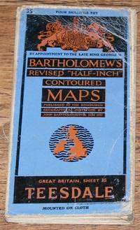
Teesdale - Bartholomew's Revised "Half-Inch" Contoured Maps, Great Britain Sheet 35
de John Bartholomew & Son Ltd
- Usado
- Tapa blanda
- Estado
- Usado - Good Condition
- Estado de la sobrecubierta
- No Dust Jacket
- Edición
- Revised Edition
- Encuadernación
- Paperback
- Cantidad disponible
- 1
- Librería
-
Doncaster, Aberdeen, United Kingdom
- Precio
-
EUR 5.88
Mostrar detalles
Descripción:
John Bartholomew & Son Ltd, Edinburgh, 1947. Revised Edition. Softcover. Good Condition/No Dust Jacket. Single sheet map is mounted on cloth and has blue card covers. Sheet is folded as for original sale. Scale 1:126,720 or Half-Inch to Mile. Map is coloured according to contour and main roads are shown in red. Rivers, railways, canals, etc. are clearly indicated. A and B road numbers are given. County boundaries and Overhead Electrical Power Lines also shown. Covers are worn and a little marked and rubbed. Sheet is slightly worn and darkened around the edges. Several folds have short splits at the edges and the folds are worn and in places deteriorated. Area covered includes; West Hartlepool, Middlesborough, Darlington, Ripon, Kirkby Lonsdale, Richmond, Middleham, Leyburn, Barnard Castle, Appleby, Bishop Auckland. Size: 84x57cm. Single sheet map/chart which is suitable for framing. Quantity Available: 1. Shipped Weight: under 1 kg. Pictures of this item not already displayed here available…
Leer más Precio
EUR 5.88

Edinburgh Atlas-Guide
de John Bartholomew & Son Ltd
- Usado
- Aceptable
- Estado
- Usado - Fine
- Cantidad disponible
- 1
- Librería
-
Gloucester City, New Jersey, United States
- Precio
-
EUR 18.85
Mostrar detalles
Descripción:
Edinburgh: John Bartholomew & Son Ltd, 1961. Softcover. Fine. Third edition. Paperback. Maps. Illustrations. Creases on some pages, minor wear to the corners, else a fine copy in wrappers.
Precio
EUR 18.85
Más fotos
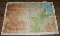
Teesdale - Bartholomew's Revised "Half-Inch" Contoured Map of England & Wales, Sheet 4
de John Bartholomew & Son Ltd
- Usado
- Tapa blanda
- Estado
- Usado - Very Good Condition
- Estado de la sobrecubierta
- No Dust Jacket
- Edición
- Revised Edition
- Encuadernación
- Paperback
- Cantidad disponible
- 1
- Librería
-
Doncaster, Aberdeen, United Kingdom
- Precio
-
EUR 6.47
Mostrar detalles
Descripción:
John Bartholomew & Son Ltd, Edinburgh, 1932. Revised Edition. Softcover. Very Good Condition/No Dust Jacket. Single sheet map is dissected and mounted on cloth and has blue card covers. Sheet is folded as for original sale. Scale 1:126,720 or 2 Miles to an Inch. Map is coloured according to contour and main roads are shown in red. Rivers, railways, canals, etc. are clearly indicated. A and B road numbers are given. Covers are a little worn and rubbed. Sheet is slightly worn and darkened around the edges but map is bright and clear. Minor annotation in bottom left margin. Area covered includes; West Hartlepool, Middlesborough, Durham, Darlington, Northallerton, Barnard Castle, Middleton, Bishop Auckland, Stockton on Tees, Richmond. Undated by publisher. Single sheet map/chart which is suitable for framing. Estimated date only. Quantity Available: 1. Shipped Weight: under 1 kg. Pictures of this item not already displayed here available upon request. Inventory No: 45119103042. For international…
Leer más Precio
EUR 6.47
