Descripción:
The Times, London, 1920. First Edition. Softcover. Very Good Condition/No Dust Jacket. Map Disbound single sheet with vertical centre fold from the 1920 "The Times Survey Atlas of the World". Map is in colour and suitable for framing. Colour according to contour. Map at scale 1:2,500,000. Map covers; Manitora (as far north as Clearwater Lake only), Ontario (part), North Dakota (part), Minnesota (part), Lake Winnipeg, Lake Superior, Lake Nipigon, Brandon, Winnipeg, Fort William, Sault Ste Marie, Albany River, Duluth, etc. Slightly darkened edges with very occasional light foxing in margins but sheet is otherwise clean and crisp. Item Type: Map. Single sheet map/chart which is suitable for framing and will be shipped rolled and in a cardboard tube. Quantity Available: 1. Shipped Weight: under 1 kg. Pictures of this item not already displayed here available upon request. Inventory No: 45020034020. For international tracking please select Priority shipping service..
Resultados de búsqueda: the times survey atlas of the
Has buscado:
- Título: the times survey atlas of the
- Autor: j g bartholomew
Resultados: 1 - 20 de 38

Más fotos
Map of Manitoba and North-West Ontario, Canada from the 1920 Times Survey Atlas (Plate 87)
de The Times and J. G. Bartholomew
- Usado
- Tapa blanda
- First
- Estado
- Usado - Very Good Condition
- Edición
- First Edition
- Encuadernación
- Paperback
- Cantidad disponible
- 1
- Librería
-
Doncaster, Aberdeen, United Kingdom
- Precio
-
EUR 23.67EUR 17.16 enviando a USA
Mostrar detalles
Precio
EUR 23.67
EUR 17.16
enviando a USA

Más fotos
Map of Alberta and Saskatchewan, Canada from the 1920 Times Survey Atlas (Plate 88) including part of Manitoba
de The Times and J. G. Bartholomew
- Usado
- Tapa blanda
- First
- Estado
- Usado - Very Good Condition
- Edición
- First Edition
- Encuadernación
- Paperback
- Cantidad disponible
- 1
- Librería
-
Doncaster, Aberdeen, United Kingdom
- Precio
-
EUR 23.67EUR 17.16 enviando a USA
Mostrar detalles
Descripción:
The Times, London, 1920. First Edition. Softcover. Very Good Condition/No Dust Jacket. Map Disbound single sheet with vertical centre fold from the 1920 "The Times Survey Atlas of the World". Map is in colour and suitable for framing. Colour according to contour. Map at scale 1:2,500,000. Map covers; Alberta (part), Saskatchewan (as far north as Frobisher Lake only), Manitoba (part), Lake Winnipeg (part), USA Border, Montanna (part), North Dakota (part), Edmonton, Calgary, Rocky Mountains (part), Regina, Saskatoon, Brandon, etc. Slightly darkened edges but sheet is otherwise clean and crisp. Item Type: Map. Single sheet map/chart which is suitable for framing and will be shipped rolled and in a cardboard tube. Quantity Available: 1. Shipped Weight: under 1 kg. Pictures of this item not already displayed here available upon request. Inventory No: 45020034019. For international tracking please select Priority shipping service..
Precio
EUR 23.67
EUR 17.16
enviando a USA

Más fotos
Map of Eastern China from the 1920 Times Survey Atlas (Plate 64) including Hankow, Anking, Nanking, Hangchow, Shanghai, Ningpo, Foochow, Canton, Hong Kong, Peking, Tientsin, Tsinan, Amoy and Taiwan (Formosa)
de The Times and J. G. Bartholomew
- Usado
- Tapa blanda
- First
- Estado
- Usado - Very Good Condition
- Edición
- First Edition
- Encuadernación
- Paperback
- Cantidad disponible
- 1
- Librería
-
Doncaster, Aberdeen, United Kingdom
- Precio
-
EUR 23.67EUR 17.16 enviando a USA
Mostrar detalles
Descripción:
The Times, London, 1920. First Edition. Softcover. Very Good Condition/No Dust Jacket. Map Disbound single sheet with vertical centre fold from the 1920 "The Times Survey Atlas of the World". Map is in colour and suitable for framing. Province boundaries are marked in different colours with colour infill in matching paler colours, seas are coloured blue. Map at scale 1:3,000,000 and split over two continuation panels. Map covers Kiangsi, Anhwei, Shantung, Fukien, Kwangtung, Chekiang, Chinli, Kiangsu, Hankow, Anking, Nanking, Hangchow, Shanghai, Ningpo, Foochow, Canton, Hong Kong, Peking, Tientsin, Tsinan, Amoy, Taiwan (Formosa), Gulf of Pechihli, Gulf og Liaotung, etc. Slightly darkened edges with occasional light foxing in margins, sheet is otherwise clean and crisp. Item Type: Map. Single sheet map/chart which is suitable for framing and will be shipped rolled and in a cardboard tube. Quantity Available: 1. Shipped Weight: under 1 kg. Pictures of this item not already displayed here…
Leer más Precio
EUR 23.67
EUR 17.16
enviando a USA

Más fotos
Map of "India - Southern Section" from the 1920 Times Survey Atlas (Plate 58) covering Mysore, Hyrerabad, Central Provinces, Ceylon (Sri Lanka), Kathainwar, Bombay, Baroda, Chota, Laccadive Islands, etc
de The Times and J. G. Bartholomew
- Usado
- Tapa blanda
- First
- Estado
- Usado - Very Good Condition
- Edición
- First Edition
- Encuadernación
- Paperback
- Cantidad disponible
- 1
- Librería
-
Doncaster, Aberdeen, United Kingdom
- Precio
-
EUR 23.67EUR 17.16 enviando a USA
Mostrar detalles
Descripción:
The Times, London, 1920. First Edition. Softcover. Very Good Condition/No Dust Jacket. Map Disbound single sheet with horizontal centre fold from the 1920 "The Times Survey Atlas of the World". Map is in colour and suitable for framing. Colour on both land and sea according to contour. Map at scale 1:4,000,000 with small inset map of Bombay at scale 1:340,000. Map covers; India (part), Mysore, Hyrerabad, Central Provinces, Ceylon (Sri Lanka), Colombo, Kathainwar, Bombay, Baroda, Chota, Coromandel Coast, Laccadive Islands, Bay of Bengal (part), Gulf of Cambay, Gulf of Manar, Arabian Sea (part), etc. Slightly darkened edges with occasional light foxing or staining in margins but sheet is otherwise clean and crisp. Item Type: Map. Single sheet map/chart which is suitable for framing and will be shipped rolled and in a cardboard tube. Quantity Available: 1. Shipped Weight: under 1 kg. Pictures of this item not already displayed here available upon request. Inventory No: 45020034035. For…
Leer más Precio
EUR 23.67
EUR 17.16
enviando a USA
Más fotos
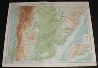
Map of Part of South America including parts of Argentina, Chile, Brazil, Paraguay and Uruguay from the 1920 Times Survey Atlas (Plate 101 Argentina, Chile, &c.)
de The Times and J. G. Bartholomew
- Usado
- Tapa blanda
- First
- Estado
- Usado - Very Good Condition
- Edición
- First Edition
- Encuadernación
- Paperback
- Cantidad disponible
- 1
- Librería
-
Doncaster, Aberdeen, United Kingdom
- Precio
-
EUR 23.67EUR 17.16 enviando a USA
Mostrar detalles
Descripción:
The Times, London, 1920. First Edition. Softcover. Very Good Condition/No Dust Jacket. Map Disbound single sheet with vertical centre fold from the 1920 "The Times Survey Atlas of the World". Map is in colour and suitable for framing. Colour on both land and sea according to contour. Map at scale 1:5,000,000. Map includes parts of countries in South America; Chile from San Pablo in the North to Valdivia in the South, Argentina to Bahia Blanca in the South, Uruguay, Brazil as far North as Rio de Janeiro (shown in inset map) and Paraguay. Also included is the Atlantic Ocean and Pacific Ocean coasts. Slightly darkened edges but sheet is otherwise clean and crisp. Item Type: Map. Single sheet map/chart which is suitable for framing and will be shipped rolled and in a cardboard tube. Quantity Available: 1. Shipped Weight: under 1 kg. Pictures of this item not already displayed here available upon request. Inventory No: 45020034009. For international tracking please select Priority shipping service..
Leer más Precio
EUR 23.67
EUR 17.16
enviando a USA

Más fotos
Map of British Columbia, Canada from the 1920 Times Survey Atlas (Plate 89) including part of Alberta, Vancouver Island, Queen Charlotte Islands and Prince of Wales Island etc
de The Times and J. G. Bartholomew
- Usado
- Tapa blanda
- First
- Estado
- Usado - Very Good Condition
- Edición
- First Edition
- Encuadernación
- Paperback
- Cantidad disponible
- 1
- Librería
-
Doncaster, Aberdeen, United Kingdom
- Precio
-
EUR 23.67EUR 17.16 enviando a USA
Mostrar detalles
Descripción:
The Times, London, 1920. First Edition. Softcover. Very Good Condition/No Dust Jacket. Map Disbound single sheet with vertical centre fold from the 1920 "The Times Survey Atlas of the World". Map is in colour and suitable for framing. Colour on both land and sea according to contour. Map at scale 1:2,500,000. Map covers; British Columbia (as far North as Zarembo Island), Alberta (part), Rocky Mountains, Vancouver Island, US Border, Washington (part), Idaho (part), Montana (part), Calgary, Edmonton, Lesser Slave Lake, Graham Island, Hecate Strait, Strait of Juan de Fuca, Fraser River, etc. Sheet contains small inset map of Vancouver and New Westminster at 1:500,000. Slightly darkened edges and occasional light foxing in margins but sheet is otherwise clean and crisp. Item Type: Map. Single sheet map/chart which is suitable for framing and will be shipped rolled and in a cardboard tube. Quantity Available: 1. Shipped Weight: under 1 kg. Pictures of this item not already displayed here…
Leer más Precio
EUR 23.67
EUR 17.16
enviando a USA

Más fotos
Map of Eastern Queensland, Australia from the 1920 Times Survey Atlas (Plate 109) including inset map of Brisbane and Environs
de The Times and J. G. Bartholomew
- Usado
- Tapa blanda
- First
- Estado
- Usado - Very Good Condition
- Edición
- First Edition
- Encuadernación
- Paperback
- Cantidad disponible
- 1
- Librería
-
Doncaster, Aberdeen, United Kingdom
- Precio
-
EUR 26.03EUR 17.16 enviando a USA
Mostrar detalles
Descripción:
The Times, London, 1920. First Edition. Softcover. Very Good Condition/No Dust Jacket. Map Disbound single sheet with horizontal centre fold from the 1920 "The Times Survey Atlas of the World". Map is in colour and suitable for framing. Colour on both land and sea according to contour. Map at scale 1:2,500,000 with inset of Brisbane at larger scale. Area covered includes: Innisfail, Tate, Numalla, Bentinck, Brisbane, Maryborough, Great Sandy Island, Northumberland Isles, Palm Isles, Gladstone, Mackay, Townsville, Great Dividing Range, Denham Range, Great Barrier Reef (part), etc. Slightly darkened edges and very occasional foxing but sheet is otherwise clean and crisp. Item Type: Map. Single sheet map/chart which is suitable for framing and will be shipped rolled and in a cardboard tube. Quantity Available: 1. Shipped Weight: under 1 kg. Pictures of this item not already displayed here available upon request. Inventory No: 45020034004. For international tracking please select Priority…
Leer más Precio
EUR 26.03
EUR 17.16
enviando a USA

Más fotos
Map of Western Section of United States from the 1920 Times Survey Atlas (Plate 92) including Washington, Oregon, Montana, Idaho, Wyoming, California, Nevada, Utah, Arizona, etc
de The Times and J. G. Bartholomew
- Usado
- Tapa blanda
- First
- Estado
- Usado - Very Good Condition
- Edición
- First Edition
- Encuadernación
- Paperback
- Cantidad disponible
- 1
- Librería
-
Doncaster, Aberdeen, United Kingdom
- Precio
-
EUR 26.03EUR 17.16 enviando a USA
Mostrar detalles
Descripción:
The Times, London, 1920. First Edition. Softcover. Very Good Condition/No Dust Jacket. Map Disbound single sheet with horizontal centre fold from the 1920 "The Times Survey Atlas of the World". Map is in colour and suitable for framing. Colour on both land and sea according to contour. Map at scale 1:5,000,000. Map covers; Washington, Oregon, Montana, Idaho, Wyoming, California, Nevada, Utah, Arizona, New Mexico (part), Colorado (part), Canadian Border, Rocky Mountains (part), Yellowstone National Park, Salt Lake City, Vancouver, Seattle, San Fransico, Los Angeles, etc. Slightly darkened edges and some foxing in margins but sheet is otherwise clean and crisp. Item Type: Map. Single sheet map/chart which is suitable for framing and will be shipped rolled and in a cardboard tube. Quantity Available: 1. Shipped Weight: under 1 kg. Pictures of this item not already displayed here available upon request. Inventory No: 45020034015. For international tracking please select Priority shipping service..
Leer más Precio
EUR 26.03
EUR 17.16
enviando a USA
Más fotos
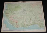
Map of West Africa from the 1920 Times Survey Atlas (Plate 76) including Ivory Coast, Liberia, Gold Coast Colony, Dahomey, Upper Volta, Upper Senegal and Niger, French Guinea, French West Africa (part), Sierra Leone, etc
de The Times and J. G. Bartholomew
- Usado
- Tapa blanda
- First
- Estado
- Usado - Very Good Condition
- Edición
- First Edition
- Encuadernación
- Paperback
- Cantidad disponible
- 1
- Librería
-
Doncaster, Aberdeen, United Kingdom
- Precio
-
EUR 26.03EUR 17.16 enviando a USA
Mostrar detalles
Descripción:
The Times, London, 1920. First Edition. Softcover. Very Good Condition/No Dust Jacket. Map Disbound single sheet with vertical centre fold from the 1920 "The Times Survey Atlas of the World". Map is in colour and suitable for framing. Colour on both land and sea according to contour with borders marked in red. Map at scale 1:5,000,000. Map covers; Ivory Coast, Liberia, Gold Coast Colony, Dahomey, Upper Volta, Upper Senegal and Niger, French Guinea, French West Africa (part), Sierra Leone, Gambia, Portuguese Guinea, Mauritania (part), Nigeria (part), Bight of Benin, etc. Slightly darkened edges with occasional light foxing in margins but sheet is otherwise clean and crisp. Item Type: Map. Single sheet map/chart which is suitable for framing and will be shipped rolled and in a cardboard tube. Quantity Available: 1. Shipped Weight: under 1 kg. Pictures of this item not already displayed here available upon request. Inventory No: 45020034033. For international tracking please select Priority…
Leer más Precio
EUR 26.03
EUR 17.16
enviando a USA
Más fotos
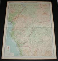
Map of Central Africa - Western Section from the 1920 Times Survey Atlas (Plate 74) including Unbangi-Shari-Chad, Cammeroons, French Equatorial Africa, Gabon, Spanish Guinea, Belgian Congo (part), Nigeria (part), etc
de The Times and J. G. Bartholomew
- Usado
- Tapa blanda
- First
- Estado
- Usado - Very Good Condition
- Edición
- First Edition
- Encuadernación
- Paperback
- Cantidad disponible
- 1
- Librería
-
Doncaster, Aberdeen, United Kingdom
- Precio
-
EUR 26.03EUR 17.16 enviando a USA
Mostrar detalles
Descripción:
The Times, London, 1920. First Edition. Softcover. Very Good Condition/No Dust Jacket. Map Disbound single sheet with horizontal centre fold from the 1920 "The Times Survey Atlas of the World". Map is in colour and suitable for framing. Colour on both land and sea according to contour with borders marked in red. Map at scale 1:5,000,000. Map covers; Unbangi-Shari-Chad, Cammeroons, Anglo-Egyptian Sudan (part), Military Territory of Chad (part), French Equatorial Africa, Gabon, Spanish Guinea, Middle Congo, Belgian Congo (part), Nigeria (part), Angola (part), Lake Chad (part), Lake Leopold II, Loanda, Fernando Po, etc. Slightly darkened edges with some foxing in margins but sheet is otherwise clean and crisp. Item Type: Map. Single sheet map/chart which is suitable for framing and will be shipped rolled and in a cardboard tube. Quantity Available: 1. Shipped Weight: under 1 kg. Pictures of this item not already displayed here available upon request. Inventory No: 45020034031. For…
Leer más Precio
EUR 26.03
EUR 17.16
enviando a USA

Más fotos
Map of North-Eastern States from the 1920 Times Survey Atlas (Plate 93) including Michigan, New York, Pensylvania, Indiana, Ohio, West Virginia, etc
de The Times and J. G. Bartholomew
- Usado
- Tapa blanda
- First
- Estado
- Usado - Very Good Condition
- Edición
- First Edition
- Encuadernación
- Paperback
- Cantidad disponible
- 1
- Librería
-
Doncaster, Aberdeen, United Kingdom
- Precio
-
EUR 26.03EUR 17.16 enviando a USA
Mostrar detalles
Descripción:
The Times, London, 1920. First Edition. Softcover. Very Good Condition/No Dust Jacket. Map Disbound single sheet with vertical centre fold from the 1920 "The Times Survey Atlas of the World". Map is in colour and suitable for framing. Colour on both land and sea according to contour. Map at scale 1:2,500,000. Map covers; Lake Michigan (part), Lake Erie, Lake Ontario (part), New York, Pensylvania, Connecticut, Massachusetts (part), Long Island, Kentucky, Indiana, Ohio, West Virginia, Virginia, Tennessee (part), North Carolina (part) and Atlantic Ocean (part). Slightly darkened edges and light foxing in margins but sheet is otherwise clean and crisp. Item Type: Map. Single sheet map/chart which is suitable for framing and will be shipped rolled and in a cardboard tube. Quantity Available: 1. Shipped Weight: under 1 kg. Pictures of this item not already displayed here available upon request. Inventory No: 45020034014. For international tracking please select Priority shipping service..
Precio
EUR 26.03
EUR 17.16
enviando a USA
Más fotos
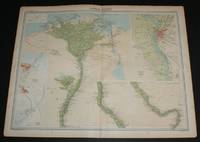
Map of "Lower Egypt" from the 1920 Times Survey Atlas (Plate 79) including Suez Canal and plans of Cairo, Port Said and Suez and environs
de The Times and J. G. Bartholomew
- Usado
- Tapa blanda
- First
- Estado
- Usado - Very Good Condition
- Edición
- First Edition
- Encuadernación
- Paperback
- Cantidad disponible
- 1
- Librería
-
Doncaster, Aberdeen, United Kingdom
- Precio
-
EUR 26.03EUR 17.16 enviando a USA
Mostrar detalles
Descripción:
The Times, London, 1920. First Edition. Softcover. Very Good Condition/No Dust Jacket. Map Disbound single sheet with vertical centre fold from the 1920 "The Times Survey Atlas of the World". Map is in colour and suitable for framing. Map at scale 1:1,000,000 with two inset continuation panels and a further three plans; Environs of Cairo at 1:150,000 and Suez and Port Said at 1:50,000. Map covers Egypt (part), Alexandria, Rosetta, Damietta, Ismailiya, Port Said, Suez Canal, Cairo, Helwan, Pyramids of Abusir and Saqqara, Medina, Minia, Asyut, Tahta, Ekhmim, Wady Natrun, etc. Slightly darkened edges with some occasional foxing in margins. Top edge of sheet is bumped and has slightly heavier foxing but sheet is otherwise clean and crisp. Item Type: Map. Single sheet map/chart which is suitable for framing and will be shipped rolled and in a cardboard tube. Quantity Available: 1. Shipped Weight: under 1 kg. Pictures of this item not already displayed here available upon request. Inventory…
Leer más Precio
EUR 26.03
EUR 17.16
enviando a USA

Más fotos
Map of South Australia from the 1920 Times Survey Atlas (Plate 110) including inset map of Adelaide and Environs
de The Times and J. G. Bartholomew
- Usado
- Tapa blanda
- First
- Estado
- Usado - Very Good Condition
- Edición
- First Edition
- Encuadernación
- Paperback
- Cantidad disponible
- 1
- Librería
-
Doncaster, Aberdeen, United Kingdom
- Precio
-
EUR 26.03EUR 17.16 enviando a USA
Mostrar detalles
Descripción:
The Times, London, 1920. First Edition. Softcover. Very Good Condition/No Dust Jacket. Map Disbound single sheet with horizontal centre fold from the 1920 "The Times Survey Atlas of the World". Map is in colour and suitable for framing. Colour on both land and sea according to contour. Map at scale 1:2,500,000 with inset of Adelaide at larger scale. Area covered includes: Lake Eyre, Lake Torrens, Lake Frome, Lake Gairdner, Spencer Gulf, Carnarvon or Kangaroo Island, Gulf of St. Vincent, Adelaide, Stuarts Range, etc. Slightly darkened edges, sheet some foxing in the margins and has occasional light foxing in the mapped area but is otherwise clean and crisp. Item Type: Map. Single sheet map/chart which is suitable for framing and will be shipped rolled and in a cardboard tube. Quantity Available: 1. Shipped Weight: under 1 kg. Pictures of this item not already displayed here available upon request. Inventory No: 45020034003. For international tracking please select Priority shipping service..
Leer más Precio
EUR 26.03
EUR 17.16
enviando a USA

Más fotos
Map of Maritime Provinces and Newfoundland, Canada from the 1920 Times Survey Atlas (Plate 85) including Prince Edward Island, Anticost Island, New Brunswick, Nova Scotia, Cape Breton Island and the Gulf of St. Lawrence
de The Times and J. G. Bartholomew
- Usado
- Tapa blanda
- First
- Estado
- Usado - Very Good Condition
- Edición
- First Edition
- Encuadernación
- Paperback
- Cantidad disponible
- 1
- Librería
-
Doncaster, Aberdeen, United Kingdom
- Precio
-
EUR 26.03EUR 17.16 enviando a USA
Mostrar detalles
Descripción:
The Times, London, 1920. First Edition. Softcover. Very Good Condition/No Dust Jacket. Map Disbound single sheet with vertical centre fold from the 1920 "The Times Survey Atlas of the World". Map is in colour and suitable for framing. Colour on both land and sea according to contour. Map at scale 1:2,500,000. Map covers; Newfoundland, New Brunswick, Quebec (part), Maine (part), Nova Scotia, Prince Edward Island, Cape Breton Island, Anticosti Island, Gulf of St. Lawrence, Magdalen Island, Bay of Fundy, Northumberland Strait, etc. Sheet contains inset plan of Halifax at scale 1:150,000. Slightly darkened edges with occasional light foxing in margins but sheet is otherwise clean and crisp. Item Type: Map. Single sheet map/chart which is suitable for framing and will be shipped rolled and in a cardboard tube. Quantity Available: 1. Shipped Weight: under 1 kg. Pictures of this item not already displayed here available upon request. Inventory No: 45020034022. For international tracking please…
Leer más Precio
EUR 26.03
EUR 17.16
enviando a USA

Más fotos
Map of "Persia" or modern day Iran from the 1920 Times Survey Atlas (Plate 53) including Bagdad, Basra, Bushire, Tabriz, Isfahan, Teheran, Fars, Khorasan, Kerman, Yezd and the Persian Gulf
de The Times and J. G. Bartholomew
- Usado
- Tapa blanda
- First
- Estado
- Usado - Very Good Condition
- Edición
- First Edition
- Encuadernación
- Paperback
- Cantidad disponible
- 1
- Librería
-
Doncaster, Aberdeen, United Kingdom
- Precio
-
EUR 26.03EUR 17.16 enviando a USA
Mostrar detalles
Descripción:
The Times, London, 1920. First Edition. Softcover. Very Good Condition/No Dust Jacket. Map Disbound single sheet with vertical centre fold from the 1920 "The Times Survey Atlas of the World". Map is in colour and suitable for framing. Colour on both land and sea is by contour. Map at scale 1:4,000,000. Map covers modern day Iran with parts of Baluchistan, Afghanistan, Arabia, Mesopotamia and Qatar (Pakistan, Iraq) with Bagdad, Basra, Bushire, Tabriz, Isfahan, Teheran, Fars, Khorasan, Kerman, Yezd, the Persian Gulf, Strait of Ormuz, Caspian Sea (part), etc. Slightly darkened edges with occasional foxing in margins and near centre fold, sheet is otherwise clean and crisp. Item Type: Map. Single sheet map/chart which is suitable for framing and will be shipped rolled and in a cardboard tube. Quantity Available: 1. Shipped Weight: under 1 kg. Pictures of this item not already displayed here available upon request. Inventory No: 45020034055. For international tracking please select Priority…
Leer más Precio
EUR 26.03
EUR 17.16
enviando a USA
Más fotos
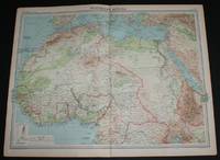
Map of Northern Africa from the 1920 Times Survey Atlas (Plate 69) including Morocco, Algeria, Libya, Egypt, Senegal, French West Africa, Nigeria, Cameroon, Uganda, Red Sea, etc
de The Times and J. G. Bartholomew
- Usado
- Tapa blanda
- First
- Estado
- Usado - Very Good Condition
- Edición
- First Edition
- Encuadernación
- Paperback
- Cantidad disponible
- 1
- Librería
-
Doncaster, Aberdeen, United Kingdom
- Precio
-
EUR 28.40EUR 17.16 enviando a USA
Mostrar detalles
Descripción:
The Times, London, 1920. First Edition. Softcover. Very Good Condition/No Dust Jacket. Map Disbound single sheet with vertical centre fold from the 1920 "The Times Survey Atlas of the World". Map is in colour and suitable for framing. Colour on both land and sea according to contour with borders marked in red. Map at scale 1:12,000,000. Map covers; Morocco, Algeria, Libya, Egypt, Senegal, French West Africa, Nigeria, Cameroon, Uganda, Ivory Coast, Gold Coast, French Guinea, Borku, Chad, Abyssinia (part), Belgian Congo (part), Madeira Islands, Canary Islands, Spain (part), Red Sea, Gulf of Guinea, Mediterranean Sea (part), Arabia (part), etc. Slightly darkened edges with occasional light foxing in margins but sheet is otherwise clean and crisp. Item Type: Map. Single sheet map/chart which is suitable for framing and will be shipped rolled and in a cardboard tube. Quantity Available: 1. Shipped Weight: under 1 kg. Pictures of this item not already displayed here available upon request.…
Leer más Precio
EUR 28.40
EUR 17.16
enviando a USA
Más fotos
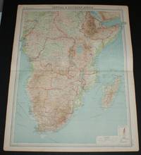
Map of Central & Southern Africa from the 1920 Times Survey Atlas (Plate 70) including Cameroons, Gambon, French Equatorial Africa, Abyssinia, Belgian Congo, Tanganyika Territory, Angola, Rhodesias, Transvaal, Madagascar, etc
de The Times and J. G. Bartholomew
- Usado
- Tapa blanda
- First
- Estado
- Usado - Very Good Condition
- Edición
- First Edition
- Encuadernación
- Paperback
- Cantidad disponible
- 1
- Librería
-
Doncaster, Aberdeen, United Kingdom
- Precio
-
EUR 28.40EUR 17.16 enviando a USA
Mostrar detalles
Descripción:
The Times, London, 1920. First Edition. Softcover. Very Good Condition/No Dust Jacket. Map Disbound single sheet with vertical centre fold from the 1920 "The Times Survey Atlas of the World". Map is in colour and suitable for framing. Colour on both land and sea according to contour with borders marked in red. Map at scale 1:12,000,000. Map covers; Cameroons, Gambon, French Equatorial Africa, Abyssinia, Belgian Congo, Tanganyika Territory, Angola, Rhodesias, Transvaal, Bechuanaland, Natal, Cape of Good Hope, Zanzibar, Socotra, Madagascar, Gulf of Aden, Azanain Sea, etc. Slightly darkened edges with occasional light foxing in margins but sheet is otherwise clean and crisp. Item Type: Map. Single sheet map/chart which is suitable for framing and will be shipped rolled and in a cardboard tube. Quantity Available: 1. Shipped Weight: under 1 kg. Pictures of this item not already displayed here available upon request. Inventory No: 45020034029. For international tracking please select Priority…
Leer más Precio
EUR 28.40
EUR 17.16
enviando a USA
Más fotos
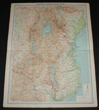
Map of Central Africa - Eastern Section from the 1920 Times Survey Atlas (Plate 75) including Lake Victoria, Uganda, Kenya Colony, Tanganyika Territory, Belgian Congo (part), Northern Rhodesia (part), Nyasaland Protectorate, etc
de The Times and J. G. Bartholomew
- Usado
- Tapa blanda
- First
- Estado
- Usado - Very Good Condition
- Edición
- First Edition
- Encuadernación
- Paperback
- Cantidad disponible
- 1
- Librería
-
Doncaster, Aberdeen, United Kingdom
- Precio
-
EUR 28.40EUR 17.16 enviando a USA
Mostrar detalles
Descripción:
The Times, London, 1920. First Edition. Softcover. Very Good Condition/No Dust Jacket. Map Disbound single sheet with horizontal centre fold from the 1920 "The Times Survey Atlas of the World". Map is in colour and suitable for framing. Colour on both land and sea according to contour with borders marked in red. Map at scale 1:5,000,000. Map covers; Lake Victoria, Lake Nyasa, Lake Tanganyika, Lake Albert, Uganda, Kenya Colony, Tanganyika Territory, Belgian Congo (part), Northern Rhodesia (part), Nyasaland Protectorate, Portuguese East Africa (part), Zanzibar, Azanian Sea, etc. Slightly darkened edges with occasional light foxing in margins but sheet is otherwise clean and crisp. Item Type: Map. Single sheet map/chart which is suitable for framing and will be shipped rolled and in a cardboard tube. Quantity Available: 1. Shipped Weight: under 1 kg. Pictures of this item not already displayed here available upon request. Inventory No: 45020034032. For international tracking please select…
Leer más Precio
EUR 28.40
EUR 17.16
enviando a USA

Más fotos
Map of Victoria and Tasmania, Australia from the 1920 Times Survey Atlas (Plate 107) including inset maps of Melbourne and Hobart and environs
de The Times and J. G. Bartholomew
- Usado
- Tapa blanda
- First
- Estado
- Usado - Very Good Condition
- Edición
- First Edition
- Encuadernación
- Paperback
- Cantidad disponible
- 1
- Librería
-
Doncaster, Aberdeen, United Kingdom
- Precio
-
EUR 28.40EUR 17.16 enviando a USA
Mostrar detalles
Descripción:
The Times, London, 1920. First Edition. Softcover. Very Good Condition/No Dust Jacket. Map Disbound single sheet with horizontal centre fold from the 1920 "The Times Survey Atlas of the World". Map is in colour and suitable for framing. Colour on both land and sea according to contour. Map at scale 1:2,500,000 with insets of Melbourne and Hobart at larger scales and street plan of Melbourne at 1:150,0000. Area covered includes: Canberra, Cape Howe, Murray River, Furneaux Group, King Island, Bass Strait, Melbourne, Port Phillip Bay, Geelong, Discovery Bay, Horbart, Hunters Islands, Tasman's Peninsula, etc. Slightly darkened edges and very occasional foxing but sheet is otherwise clean and crisp. Item Type: Map. Single sheet map/chart which is suitable for framing and will be shipped rolled and in a cardboard tube. Quantity Available: 1. Shipped Weight: under 1 kg. Pictures of this item not already displayed here available upon request. Inventory No: 45020034006. For international…
Leer más Precio
EUR 28.40
EUR 17.16
enviando a USA

Más fotos
Map of Eastern Section of United States from the 1920 Times Survey Atlas (Plate 90) including Michigan, Indiana, Ohio, Pennsylvania, New York, Maine, Virginia, Kentucky, North Carolina, Alabama, Georgia, Florida, Niagara Falls etc
de The Times and J. G. Bartholomew
- Usado
- Tapa blanda
- First
- Estado
- Usado - Very Good Condition
- Edición
- First Edition
- Encuadernación
- Paperback
- Cantidad disponible
- 1
- Librería
-
Doncaster, Aberdeen, United Kingdom
- Precio
-
EUR 28.40EUR 17.16 enviando a USA
Mostrar detalles
Descripción:
The Times, London, 1920. First Edition. Softcover. Very Good Condition/No Dust Jacket. Map Disbound single sheet with horizontal centre fold from the 1920 "The Times Survey Atlas of the World". Map is in colour and suitable for framing. Colour on both land and sea according to contour. Map at scale 1:5,000,000. Map covers; Michigan, Indiana, Ohio, Pennsylvania, New York, Maine, Vermont, New Hampshire, Massachusetts, West Virginia, Kentucky, North and South Carolina, Alabama, Georgia, Florida, Nova Scotia, Lake Erie, Lake Ontario, Lake Michigan, Lake Huron, Boston, New York, Philadelphia, Montreal, Ottawa, etc. Sheet contains two inset maps; Niagara Falls and environs and Population Denisity for USA. Slightly darkened edges and occasional light foxing in margins but sheet is otherwise clean and crisp. Item Type: Map. Single sheet map/chart which is suitable for framing and will be shipped rolled and in a cardboard tube. Quantity Available: 1. Shipped Weight: under 1 kg. Pictures of this…
Leer más Precio
EUR 28.40
EUR 17.16
enviando a USA

¿No has encontrado lo que estabas buscando?
Prueba a añadir esta búsqueda a búsquedas guardadas Cada día se añaden millones de libros a Biblio. Cuando uno de ellos encaje con tu búsqueda, te enviaremos un correo para avisarte. Y lo mejor de todo, ¡es gratis!
Añadir a búsquedas guardadas

¿Eres un lector habitual o un coleccionista de libros?
Únete al Biblioclub y ahorra 10% en cada compra, ¡cada día! Hasta un máximo de 20$ en cada pedido

Responsabilidad social
¿Sabías que desde 2004 Biblio ha destinado sus beneficios a la construcción de 16 bibliotecas públicas en zonas rurales de Latinoamérica?
