Descripción:
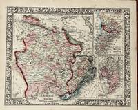
[Philadelphia]: [W.M. Bradley], 1886. Very good,minor soiling, one closed edge tear, not affecting contents.. Hand colored map. 13.75 x 10.5 inches. Plate 112. Russia in Europe, Sweden, and Norway, insets of Map of Denmark, and Map of Holland and Belgium. Copyright by S. Augustus Mitchell 1884. From: Mitchell's New General Atlas, Containing Maps Of The Various Countries Of The World, Plans Of Cities, Etc., Embraced In Ninety-Three Quarto Maps, Forming A Series Of One Hundred and Forty-seven Maps and Plans, Together With Valuable Statistical Tables. Also, A List Of Post-Offices Of The United States And Territories, And Also Census Of 1880 For States, Territories And Counties, Also Of Cities Of Over 10,000 Inhabitants. Philadelphia: Published By Wm. M. Bradley & Bro., No. 1026 Arch Street. 1886.
Resultados de búsqueda: russia in europe sweden and norway
Has buscado:
- Título: russia in europe sweden and norway
- Autor: mitchell s augustus
Resultados: 1 - 5 de 5
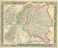
![[Map] Russia in Europe, Sweden, and Norway [with insets] Map of Denmark [and] Map of Holland and...](https://d3525k1ryd2155.cloudfront.net/h/097/053/1465053097.0.m.jpg)
[Map] Russia in Europe, Sweden, and Norway [with insets] Map of Denmark [and] Map of Holland and Belgium
de Mitchell, S. Augustus, Jr.
- Usado
- Estado
- Usado - Very good,minor soiling, one closed edge tear, not affecting contents.
- Cantidad disponible
- 1
- Librería
-
East Jewett, New York, United States
- Precio
-
EUR 37.70EUR 6.60 enviando a USA
Mostrar detalles
Precio
EUR 37.70
EUR 6.60
enviando a USA

Russia in Europe, Sweden and Norway: Denmark, Holland and Belgium
de Mitchell, S. Augustus
- Usado
- very good
- Estado
- Usado - Very good
- Edición
- 1867 edition
- Cantidad disponible
- 1
- Librería
-
Franklin, Tennessee, United States
- Precio
-
EUR 42.41EUR 5.66 enviando a USA
Mostrar detalles
Descripción:
Philadelphia: Mitchell, S. Augustus, 1867. 1867 edition. 13 1/4 x 10 3/4 inches. Very good. Mitchell, S. Augustus. Finely colored by contemporary hand map of the Russian Empire. Map shows The map show North Cape Norway to the Georgiain the south. It shows from Denmark in the west to Orenburg in the east. There is a small inset maps of Denmark and another of Holland and Belgium.
Precio
EUR 42.41
EUR 5.66
enviando a USA
Russia in Europe, Sweden and Norway
de Mitchell, S. Augustus
- Usado
- very good
- Estado
- Usado - Very good
- Cantidad disponible
- 1
- Librería
-
Franklin, Tennessee, United States
- Precio
-
EUR 47.12EUR 5.66 enviando a USA
Mostrar detalles
Descripción:
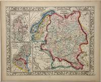
Philadelphia: Mitchell, S. Augustus, 1860. 13 1/2 x 10 1/2 inches. Very good. Classic Mitchell presentation on a small scale. It shows the Northern Ocean with Norway in the west and Asia in the east. The Adriatic in the southwest and the Caspian in the southeast frame out the presentation. Two inset maps adorn the western section. Denmark is shown in the upper window. A Map of Belgium and Holland occupies the lower left. This is an excellent cartographic artifact.
Precio
EUR 47.12
EUR 5.66
enviando a USA
Russia In Europe, Sweden, and Norway. With Inset Maps of Denmark, Holland, and Belgium. Entered, according to Act of Congress in the year 1860 by S. Augustus Mitchell, Jr. in the Clerks Office of the District Court of the U.S. for the Eastern District of Pennsylvania.
de S. Augustus Mitchell, Jr.
- Usado
- Estado
- Usado
- Cantidad disponible
- 1
- Librería
-
San Francisco, California, United States
- Precio
-
EUR 47.12EUR 7.54 enviando a USA
Mostrar detalles
Descripción:
Philadelphia, PA: Augustus Mitchell, 1860.. 15.5" x 12.75" Hand-colored lithograph, Oblong, Good with tiny loss at corner, minor tears, toning, creasing.
Precio
EUR 47.12
EUR 7.54
enviando a USA
Más fotos
Map of Russia in Europe, Sweden and Norway, with inset of Map of Denmark and Map of Holland and Belgium from the New Universal Atlas.
de S. Augustus Mitchell, Jr.
- Usado
- Aceptable
- First
- Estado
- Usado - Fine
- Edición
- First edition
- Cantidad disponible
- 1
- Librería
-
Langley, Washington, United States
- Precio
-
EUR 183.79EUR 9.42 enviando a USA
Mostrar detalles
Descripción:
Philadelphia:: S. Augustus Mitchell,, 1860.. First edition. Fine . Fine original hand-colored lithograph. Folio (15.5 x 12.75 inches).
A fine and decorative pre-Civil War Map from one of America's most prolific atlas publishing firms of the nineteenth century; Samuel Augustus Mitchell, (Connecticut 1792-1868), and his son S. Augustus Mitchell, Jr. Drawn and engraved by W. Williams, this map is from the first edition of the popular New Universal Atlas which characterized by the fine topographical detail of the charted territory here heightened with rich watercolor, all surrounded by an embellished floral border. Single Sheet
Precio
EUR 183.79
EUR 9.42
enviando a USA

¿No has encontrado lo que estabas buscando?
Prueba a añadir esta búsqueda a búsquedas guardadas Cada día se añaden millones de libros a Biblio. Cuando uno de ellos encaje con tu búsqueda, te enviaremos un correo para avisarte. Y lo mejor de todo, ¡es gratis!
Añadir a búsquedas guardadas

¿Eres un lector habitual o un coleccionista de libros?
Únete al Biblioclub y ahorra 10% en cada compra, ¡cada día! Hasta un máximo de 20$ en cada pedido

Responsabilidad social
¿Sabías que desde 2004 Biblio ha destinado sus beneficios a la construcción de 16 bibliotecas públicas en zonas rurales de Latinoamérica?
