Descripción:
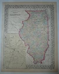
Philadelphia: Mitchell, Samuel Augustus Jr., 1869. unbound. Map. Engraving with original hand coloring. Image measures 13 3/4" x 11"<br/> <br/> Great map of Illinois divided into counties showing towns, major routes, railroads and waterways. This 1869 edition features an inset of the Vicinity of Springfield, the state's capital. Springfield rose to importance during the Civil War, serving as a training camp for Union soldiers and later as a camp for Confederate prisoners of war. After the war ended in 1865, the city became a major hub for the railroad system. In the inset we can see the Great Western Railroad and the St. Louis, Alton and Chicago Railroad transecting the city. In good condition, with chips and tears to margins. <br> <br> Samuel Augustus Mitchell Sr. (1792-1868) was one of the leaders in American cartography of the 19th century and pioneered the conversion of engraved map plates to more affordable lithographic plates. His son, Samuel Augustus…
Leer más Resultados de búsqueda: county map of the state of
Has buscado:
- Título: county map of the state of
- Autor: mitchell samuel augustus
Resultados: 1 - 20 de 28

County Map of the State of Illinois
de MITCHELL, Samuel Augustus Jr.
- Usado
- Estado
- Usado
- Cantidad disponible
- 1
- Librería
-
New York, New York, United States
- Precio
-
EUR 61.40EUR 5.67 enviando a USA
Mostrar detalles
Precio
EUR 61.40
EUR 5.67
enviando a USA
County Map Of The State Of Illinois
de Mitchell, Samuel Augustus
- Usado
- very good
- Estado
- Usado - Very Good
- Cantidad disponible
- 1
- Librería
-
Traverse City, Michigan, United States
- Precio
-
EUR 70.80EUR 5.53 enviando a USA
Mostrar detalles
Descripción:
New York: S. Augustus Mitchell. Very Good. 1874. Map. This hand-colored map with an inset of the city of Springfield and Sangamon County which is colored in light yellow. The state is outlined in red and the counties are colored in pastel green, yellow and rose. The map shows cities, towns and rail lines. From Mitchell's New General Atlas. Copyright date of 1874. A pretty map with floral border, suitable for framing. ; Hand-colored Map; 10.75 x 13.25" .
Precio
EUR 70.80
EUR 5.53
enviando a USA

County Map of the State of Illinois
de MITCHELL, Samuel Augustus Jr.
- Usado
- very good
- Estado
- Usado - very good
- Cantidad disponible
- 1
- Librería
-
New York, New York, United States
- Precio
-
EUR 70.84EUR 5.67 enviando a USA
Mostrar detalles
Descripción:
Philadelphia: Mitchell, Samuel Augustus Jr., 1866. unbound. very good. Map. Engraving with original hand coloring. Image measures 13.5" x 10.75".<br/> <br/> Great map of Illinois divided into counties showing towns, major routes, railroads and waterways. Includes a detailed town plan inset Chicago. <br> <br> Samuel Augustus Mitchell Sr. (1792-1868) was one of the leaders in American cartography of the 19th century and pioneered the conversion of engraved map plates to more affordable lithographic plates. His son, Samuel Augustus Mitchell Jr. continued his father's successful mapmaking and publishing business, and was one of the most prolific and renowned 19th century American publishers.<br/> <br/>
Precio
EUR 70.84
EUR 5.67
enviando a USA

County and Township Map of the State of Illinois
de Mitchell, Samuel Augustus Jr
- Usado
- Estado
- Usado
- Cantidad disponible
- 1
- Librería
-
Florham Park, New Jersey, United States
- Precio
-
EUR 70.84EUR 7.56 enviando a USA
Mostrar detalles
Descripción:
Philadelphia, 1870. Unbound, colored engraved map, decorative border, 14"x 11". Slight toning and aging, a little staining in the margins; overall bright and clear and in very good shape. Maps are wrapped with acid free board, or in rigid sleeves. The Mitchell family started to produce atlases in 1846, and continued into the early 1890s. Around 1860, S. Augustus Mitchell Jr. took over, and the atlas would be called Mitchell's New General Atlas. This is a nice colorful map of Illinois from the 1870 installment of that atlas. The map includes an inset that features Springfield. Ristow 311-313
Precio
EUR 70.84
EUR 7.56
enviando a USA
County Map 0f the State of Maine
de Mitchell, Samuel Augustus Jr
- Usado
- Estado
- Usado
- Cantidad disponible
- 1
- Librería
-
Florham Park, New Jersey, United States
- Precio
-
EUR 70.84EUR 7.56 enviando a USA
Mostrar detalles
Descripción:
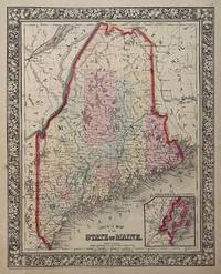
Philadelphia, 1869. Unbound, colored engraved map, decorative boarder, 14"x 11". Slight toning and aging; bright and clear, and in otherwise very good shape. Maps are wrapped with acid free board, or in rigid sleeves. The Mitchell family started to produce atlases in 1846, and continued into the early 1890s. Around 1860, S. Augustus Mitchell Jr. took over, and the atlas would be called Mitchell's New General Atlas. This is an attractive colorful single page map of Maine from the 1869 installment of that atlas. Good detail, and Portland is featured in an inset.. Ristow 311-313
Precio
EUR 70.84
EUR 7.56
enviando a USA
County Map 0f the State of Maine
de Mitchell, Samuel Augustus Jr
- Usado
- Estado
- Usado
- Cantidad disponible
- 1
- Librería
-
Florham Park, New Jersey, United States
- Precio
-
EUR 70.84EUR 7.56 enviando a USA
Mostrar detalles
Descripción:
Philadelphia, 1882. Unbound, colored engraved map, decorative boarder, 14"x 11". Slight toning and aging, minor soiling and acople of small nicks ta side edge; still bright and clear, and in otherwise very good shape. Maps are wrapped with acid free board, or in rigid sleeves. The Mitchell family started to produce atlases in 1846, and continued into the early 1890s. Around 1860, S. Augustus Mitchell Jr. took over, and the atlas would be called Mitchell's New General Atlas. This is an attractive colorful single page map of Maine from the 1869 installment of that atlas. Good detail, and Portland is featured in an inset.. Ristow 311-313
Precio
EUR 70.84
EUR 7.56
enviando a USA
County Map of the State of Pennsylvania, New Jersey, Maryland, and Delaware
de Mitchell, Samuel Augustus Jr
- Usado
- Estado
- Usado
- Cantidad disponible
- 1
- Librería
-
Florham Park, New Jersey, United States
- Precio
-
EUR 70.84EUR 7.56 enviando a USA
Mostrar detalles
Descripción:
Philadelphia, 1865. Unbound, colored engraved map, decorative boarder, 14"x 11". Slight toning and aging; overall very bright and clear and in very good shape. Maps are wrapped with acid free board, or in rigid sleeves. The Mitchell family started to produce atlases in 1846, and continued into the early 1890s. Around 1860, S. Augustus Mitchell Jr. took over, and the atlas would be called Mitchell's New General Atlas. This is a colorful map of Pennsylvania, but includes New Jersey, Maryland and Delaware, from the 1865 installment of that atlas. The map is bright and crisp, and includes inset maps of Philadelphia and Baltimore. Ristow 311-313
Precio
EUR 70.84
EUR 7.56
enviando a USA
County and Township Map of the State of Illinois
de Mitchell, Samuel Augustus Jr
- Usado
- Estado
- Usado
- Cantidad disponible
- 1
- Librería
-
Florham Park, New Jersey, United States
- Precio
-
EUR 70.84EUR 7.56 enviando a USA
Mostrar detalles
Descripción:
Philadelphia: Bradley, 1882. Unbound, colored engraved map, decorative border, 22 1/2"x 14 1/2". Slight toning and aging, a little darkening by fold; overall bright and clear and in very good shape. Maps are wrapped with acid free board, or in rigid sleeves. The Mitchell family started to produce atlases in 1846, and continued into the early 1890s. Around 1860, S. Augustus Mitchell Jr. took over, and the atlas would be called Mitchell's New General Atlas. This is a nice double page map of Illinois from the 1882 installment. The map includes an inset that features Springfield. Ristow 311-313 Phillips 907
Precio
EUR 70.84
EUR 7.56
enviando a USA
County Map of the State of Maine.
de Mitchell, Samuel Augustus Jr.
- Usado
- Estado
- Usado
- Cantidad disponible
- 1
- Librería
-
Florham Park, New Jersey, United States
- Precio
-
EUR 70.84EUR 7.56 enviando a USA
Mostrar detalles
Descripción:
Unbound, colored engraved map, decorative boarder, 14"x 11". Slight toning and aging; bright and clear, and in otherwise very good shape. Maps are wrapped with acid free board, or in rigid sleeves. The Mitchell family started to produce atlases in 1846, and continued into the early 1890s. Around 1860, S. Augustus Mitchell Jr. took over, and the atlas would be called Mitchell's New General Atlas. This is an attractive colorful single page map of Maine from the 1870 installment of that atlas. Good detail, and Portland is featured in an inset.. Ristow 311-313.
Precio
EUR 70.84
EUR 7.56
enviando a USA
County Map of the State of Pennsylvania.
de Mitchell, Samuel Augustus Jr
- Usado
- Estado
- Usado
- Cantidad disponible
- 1
- Librería
-
Florham Park, New Jersey, United States
- Precio
-
EUR 80.29EUR 7.56 enviando a USA
Mostrar detalles
Descripción:
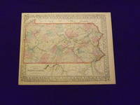
Unbound, colored engraved map, decorative boarder, 15" x 12". Slight toning and aging, margins somewhat narrow, but ample; overall bright and clear and in very good shape. Maps are wrapped with acid free board, or in rigid sleeves. The Mitchell family started to produce atlases in 1846, and continued into the early 1890s. Around 1860, S. Augustus Mitchell Jr. took over, and the atlas would be called Mitchell's New General Atlas. This is a colorful map of just the map of Pennsylvania from the 1869 installment of that atlas. While the map includes three other states, Pennsylvania is the most prominent part of the map. Insets highlight the cities of Philadelphia and Baltimore. Ristow 311-313. # 103162
Precio
EUR 80.29
EUR 7.56
enviando a USA
County Map of the State of Pennsylvania
de Mitchell, Samuel Augustus Jr
- Usado
- Estado
- Usado
- Cantidad disponible
- 1
- Librería
-
Florham Park, New Jersey, United States
- Precio
-
EUR 80.29EUR 7.56 enviando a USA
Mostrar detalles
Descripción:
Philadelphia, 1869. Unbound, colored engraved map, decorative boarder, 14"x 11". Slight toning and aging; overall bright and clear and in very good shape. Maps are wrapped with acid free board, or in rigid sleeves. The Mitchell family started to produce atlases in 1846, and continued into the early 1890s. Around 1860, S. Augustus Mitchell Jr. took over, and the atlas would be called Mitchell's New General Atlas. This is a colorful map of Pennsylvania from the 1869 installment of that atlas. The map has a nice layout, with plenty of detail. Ristow 311-313
Precio
EUR 80.29
EUR 7.56
enviando a USA
County and Township Map of the State of Illinois
de Mitchell, Samuel Augustus Jr
- Usado
- Estado
- Usado
- Cantidad disponible
- 1
- Librería
-
Florham Park, New Jersey, United States
- Precio
-
EUR 80.29EUR 7.56 enviando a USA
Mostrar detalles
Descripción:
Philadelphia, 1861. Unbound, colored engraved map, decorative border, 14"x 11". Slight toning and aging, a little staining in the margins; overall bright and clear and in very good shape. Maps are wrapped with acid free board, or in rigid sleeves. The Mitchell family started to produce atlases in 1846, and continued into the early 1890s. Around 1860, S. Augustus Mitchell Jr. took over, and the atlas would be called Mitchell's New General Atlas. This is a nice colorful map of Illinois from the 1861 installment of that atlas. The map includes an inset that features Springfield. Ristow 311-313
Precio
EUR 80.29
EUR 7.56
enviando a USA
County Map of the State of New Jersey
de Mitchell, Samuel Augustus Jr
- Usado
- Estado
- Usado
- Cantidad disponible
- 1
- Librería
-
Florham Park, New Jersey, United States
- Precio
-
EUR 80.29EUR 7.56 enviando a USA
Mostrar detalles
Descripción:
Philadelphia, 1882. Unbound, colored engraved map, 15"x 11 1/2". Some toning and aging; otherwise bright and clear. Maps are wrapped with acid free board, or in rigid sleeves. The Mitchell family started to produce atlases in 1846, and continued into the early 1890s. Around 1860, S. Augustus Mitchell Jr. took over, and the atlas would be called Mitchell's New General Atlas. This is a colorful and attractive map of New Jersey from the 1882 installment of that atlas. On the reverse of this map, is a double page map of Pennsylvania. Ristow 311-313 Phillips 907
Precio
EUR 80.29
EUR 7.56
enviando a USA
County Map of the State of Pennsylvania
de Mitchell, Samuel Augustus Jr
- Usado
- Estado
- Usado
- Cantidad disponible
- 1
- Librería
-
Florham Park, New Jersey, United States
- Precio
-
EUR 80.29EUR 7.56 enviando a USA
Mostrar detalles
Descripción:
Philadelphia, 1870. Unbound, colored engraved map, decorative boarder, 14"x 11". Slight toning and aging, a few chips at the top edge; overall bright and clear and in very good shape. Maps are wrapped with acid free board, or in rigid sleeves. The Mitchell family started to produce atlases in 1846, and continued into the early 1890s. Around 1860, S. Augustus Mitchell Jr. took over, and the atlas would be called Mitchell's New General Atlas. This is a colorful map of Pennsylvania from the 1870 installment of that atlas. Ristow 311-313
Precio
EUR 80.29
EUR 7.56
enviando a USA
County Map of the State of Maine
de MITCHELL, Samuel Augustus Jr.
- Usado
- Estado
- Usado
- Cantidad disponible
- 1
- Librería
-
New York, New York, United States
- Precio
-
EUR 118.08EUR 5.67 enviando a USA
Mostrar detalles
Descripción:
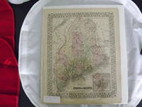
Philadelphia: Mitchell, Samuel Augustus Jr., 1860. unbound. Map. Steel engraving with original hand coloring. Image measures 13 3/8" x 10 5/8".<br/> <br/> Lovely map of Maine published in 1860 divided into counties. Shows major towns and cities, routes, railroads and waterways. Features an inset of Portland Harbor. In excellent condition, with a minor chip to lower margin not affecting the image.<br> <br> Samuel Augustus Mitchell Sr. (1792-1868) was one of the leaders in American cartography of the 19th century and pioneered the conversion of engraved map plates to more affordable lithographic plates. His son, Samuel Augustus Mitchell Jr. continued his father's successful mapmaking and publishing business, and was one of the most prolific and renowned 19th century American publishers.<br/> <br/>
Precio
EUR 118.08
EUR 5.67
enviando a USA
County Map of the State of New York
de Mitchell, Samuel Augustus Jr
- Usado
- Estado
- Usado
- Cantidad disponible
- 1
- Librería
-
Florham Park, New Jersey, United States
- Precio
-
EUR 118.08EUR 7.56 enviando a USA
Mostrar detalles
Descripción:
Philadelphia, 1869. Unbound, colored engraved map, decorative boarder, 22 1/2"x 14 1/2". Slight toning and aging; overall bright and clear and in very good shape. Maps are wrapped with acid free board, or in rigid sleeves. The Mitchell family started to produce atlases in 1846, and continued into the early 1890s. Around 1860, S. Augustus Mitchell Jr. took over, and the atlas would be called Mitchell's New General Atlas. This is an attractive double page map of New York State from the 1869 installment. Buffalo, Rochester, Albany and West Troy, and New York Harbor are highlighted in five insets. Ristow 311-313
Precio
EUR 118.08
EUR 7.56
enviando a USA
County Map of the State of New York
de Mitchell, Samuel Augustus Jr
- Usado
- Estado
- Usado
- Cantidad disponible
- 1
- Librería
-
Florham Park, New Jersey, United States
- Precio
-
EUR 141.69EUR 7.56 enviando a USA
Mostrar detalles
Descripción:
Philadelphia, 1870. Unbound, colored engraved map, decorative boarder, 22 1/2"x 14 1/2". Slight toning and aging; overall bright and clear and in very good shape. Maps are wrapped with acid free board, or in rigid sleeves. The Mitchell family started to produce atlases in 1846, and continued into the early 1890s. Around 1860, S. Augustus Mitchell Jr. took over, and the atlas would be called Mitchell's New General Atlas. This is an attractive double page map of New York State from the 1870 installment. Buffalo, Rochester, Albany and New York City are highlighted in four insets. Ristow 311-313
Precio
EUR 141.69
EUR 7.56
enviando a USA
County Map of the State of New York
de Mitchell, Samuel Augustus Jr
- Usado
- Estado
- Usado
- Cantidad disponible
- 1
- Librería
-
Florham Park, New Jersey, United States
- Precio
-
EUR 141.69EUR 7.56 enviando a USA
Mostrar detalles
Descripción:
Philadelphia, 1861. Unbound, colored engraved map, decorative boarder, 22 1/2"x 14 1/2". Slight toning and aging, just a little soiling or staining in margins; overall bright and clear and in very good shape. Maps are wrapped with acid free board, or in rigid sleeves. The Mitchell family started to produce atlases in 1846, and continued into the early 1890s. Around 1860, S. Augustus Mitchell Jr. took over, and the atlas would be called Mitchell's New General Atlas. This is an very attractive and colorful double page map of New York State from the 1861 installment. Buffalo, Rochester, Albany and New York City are highlighted in four insets. Ristow 311-313
Precio
EUR 141.69
EUR 7.56
enviando a USA
County Map of the State of New York
de Mitchell, Samuel Augustus Jr
- Usado
- Estado
- Usado
- Cantidad disponible
- 1
- Librería
-
Florham Park, New Jersey, United States
- Precio
-
EUR 141.69EUR 7.56 enviando a USA
Mostrar detalles
Descripción:
Philadelphia: Bradley, 1882. Unbound, colored engraved map, decorative boarder, 22 1/2"x 14 1/2". Slight toning and aging; overall bright and clear and in very good shape. Maps are wrapped with acid free board, or in rigid sleeves. The Mitchell family started to produce atlases in 1846, and continued into the early 1890s. Around 1860, S. Augustus Mitchell Jr. took over, and the atlas would be called Mitchell's New General Atlas. This is an attractive double page map of New York State from the 1882 installment. Buffalo, Rochester, Albany and New York City are highlighted in four insets. Ristow 311-313 Phillips 907
Precio
EUR 141.69
EUR 7.56
enviando a USA
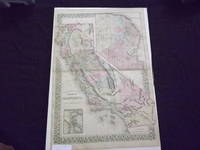
County Map of the State of California
de Mitchell, Samuel Augustus Jr
- Usado
- Estado
- Usado
- Cantidad disponible
- 1
- Librería
-
Florham Park, New Jersey, United States
- Precio
-
EUR 141.69EUR 7.56 enviando a USA
Mostrar detalles
Descripción:
Philadelphia: Bradley, 1882. Unbound, colored engraved map, decorative boarder, 22 1/2"x 14 1/2". Normal aging and toning, crease at center fold; overall very good plus. Maps are wrapped with acid free board, or in rigid sleeves. The Mitchell family started to produce atlases in 1846, and continued into the early 1890s. Around 1860, S. Augustus Mitchell Jr. took over, and the atlas would be called Mitchell's New General Atlas. This is an attractive map of California from the 1882 installment. The city of San Francisco is shown in an inset. Will require extra postage. Ristow 311-313 Phillips 907
Precio
EUR 141.69
EUR 7.56
enviando a USA

¿No has encontrado lo que estabas buscando?
Prueba a añadir esta búsqueda a búsquedas guardadas Cada día se añaden millones de libros a Biblio. Cuando uno de ellos encaje con tu búsqueda, te enviaremos un correo para avisarte. Y lo mejor de todo, ¡es gratis!
Añadir a búsquedas guardadas

¿Eres un lector habitual o un coleccionista de libros?
Únete al Biblioclub y ahorra 10% en cada compra, ¡cada día! Hasta un máximo de 20$ en cada pedido

Responsabilidad social
¿Sabías que desde 2004 Biblio ha destinado sus beneficios a la construcción de 16 bibliotecas públicas en zonas rurales de Latinoamérica?
