Descripción:
INCHES 14.6 X 10.6 INCHESNICE CONDITION BETTER THAN THE SCAN, ORIGINAL CENTREFOLDS
Resultados de búsqueda: australia
Has buscado:
- Título: australia
- Autor: tallis john
Resultados: 1 - 17 de 17

PART OF SOUTH AUSTRALIA
de JOHN TALLIS
- Usado
- Estado
- Usado
- Cantidad disponible
- 1
- Librería
-
gurgaon, India
- Precio
-
EUR 70.48EUR 19.73 enviando a USA
Mostrar detalles
Precio
EUR 70.48
EUR 19.73
enviando a USA
![Part of South Australia [Antique Map]](https://d3525k1ryd2155.cloudfront.net/h/919/287/1593287919.0.m.jpg)
Más fotos
Part of South Australia [Antique Map]
de Tallis, John; Rapkin, J.
- Usado
- very good
- Estado
- Usado - Very Good
- Cantidad disponible
- 1
- Librería
-
Cleveland, Ohio, United States
- Precio
-
EUR 89.27EUR 3.29 enviando a USA
Mostrar detalles
Descripción:
London: John Tallis, 1851. [Australia Map]. Original steel engraved map with decorative boarder and vignettes. Map size with central vertical fold is approx. 11 x 14 inches. Original antique map of "part of South Australia" by John Tallis & Company, circa 1851. Vignettes of Adelaide, Natives of Catmaran, Dingo or Australian Dog, Seal of South Australia, and Nymphicua bird. Map drawn and engraved by John Rapkin, with illustrations by H. Warren and engraved by J. Rogers. Contemporary pen outlining in color and pale blue coastline wash. By 1865 Tallis was among the last of the publishers of beautifully decorated hand engraved maps. Shows some expected page toning and light wear at corners. Very Good. Map.
Precio
EUR 89.27
EUR 3.29
enviando a USA
![Western Australia, Swan River [Antique Map]](https://d3525k1ryd2155.cloudfront.net/h/920/287/1593287920.0.m.jpg)
Más fotos
Western Australia, Swan River [Antique Map]
de Rapkin, J.; Tallis John
- Usado
- very good
- Estado
- Usado - Very Good
- Cantidad disponible
- 1
- Librería
-
Cleveland, Ohio, United States
- Precio
-
EUR 89.27EUR 3.29 enviando a USA
Mostrar detalles
Descripción:
London: John Tallis, 1851. [Australia Map]. Original steel engraved map with decorative boarder and vignettes. Map size with central vertical fold is approx. 11 x 14 inches. Original antique map of "Western Australia, Swan River" by John Tallis & Company, circa 1851. Vignettes of Sheep Shearing, Between Perth and Fremantle, Aborigines, Perth from Mount Eliza, Shepards and sheep, and Ships in harbor. Map drawn and engraved by John Rapkin, with illustrations by A.H. Wray and engraved by W. Lacey. Contemporary pen outlining in color and pale blue coastline wash. By 1865 Tallis was among the last of the publishers of beautifully decorated hand engraved maps. Shows some expected page toning and light wear at corners. Very Good. Map.
Precio
EUR 89.27
EUR 3.29
enviando a USA

South Australia.: Original Antique Map
de John Tallis & Rapkin
- Usado
- First
- Estado
- Usado
- Edición
- 1st Edition
- Cantidad disponible
- 1
- Librería
-
Plymouth, Devon, United Kingdom
- Precio
-
EUR 94.58EUR 41.38 enviando a USA
Mostrar detalles
Descripción:
Tallis, John: South Australia. London. [ca.1851]. From the Montgomery Martin Illustrated Atlas. Map engraved by Rapkin. Size approx 360 x 260mm. Original steel engraved map with original outline hand colouring and decorative border. 5 vignettes include Australian Dog, Natives on a Catamaran and Adelaide. Single page unfolded map in excellent, clean condition. Associated text page of the Montgomery Martin Atlas included. A good Tallis Map.
Precio
EUR 94.58
EUR 41.38
enviando a USA

Part of South Australia, antique map with vignette views
de Rapkin, J. Tallis, John
- Usado
- Estado
- Usado
- Cantidad disponible
- 1
- Librería
-
Garrison, New York, United States
- Precio
-
EUR 164.45EUR 7.52 enviando a USA
Mostrar detalles
Descripción:
London: John Tallis & Co., 1851. Maps. Steel engraved map from the famous Victorian publisher John Tallis, well-known for the attractive vignette views surrounding the maps, which illustrate the peoples & customs of the region. With a vignette views of Adelaide, Natives, Seal, Dingo and Nymphicus, with the mining districts marked in red. Tooley 1231. 10 x 13 1/2" plus margins. Attractive decorative border around edge, period outline color, very good condition.
Precio
EUR 164.45
EUR 7.52
enviando a USA

Western Australia - Swan River.
de RAPKIN, J. [TALLIS, John].
- Usado
- Estado
- Usado
- Cantidad disponible
- 1
- Librería
-
London, London, United Kingdom
- Precio
-
EUR 177.33EUR 10.58 enviando a USA
Mostrar detalles
Descripción:
London & New York: John Tallis & Company. [1856]. 32 x 24 cm. Original outline colour. Double page steel engraved map concentrating on the south west corner of territory of Western Australia. Six vignette illustrations including a view of Perth, sheep shearing and Aborigines. Decorative scrolling and title cartouche to the edges of the image. Light horizontal shadow line at centre from original fold. For the Great Exhibition in 1851 John Tallis (1817-1876) worked with engraver John Rapkin (1815-1876) to publish the 'Illustrated World Atlas', whose maps were later re-issued by the London Printing and Publishing Company under the Tallis imprint. Their maps are prized for their wonderful steel-engraved vignettes showing the peoples, customs, architecture, landmarks, flora, and fauna of each country.
Precio
EUR 177.33
EUR 10.58
enviando a USA

Part of South Australia.
de RAPKIN, J. & [TALLIS, John].
- Usado
- Estado
- Usado
- Cantidad disponible
- 1
- Librería
-
London, London, United Kingdom
- Precio
-
EUR 177.33EUR 10.58 enviando a USA
Mostrar detalles
Descripción:
London & New York: John Tallis & Company, [1851-1856].. Original steel engraved map concentrating on the area around Spencer Gulf, including Adelaide. Five vignette illustrations including those of Adelaide and of Aborigines. Mining districts shown. Decorative scrolling and title cartouche to the edges of the image. (Map 22 x 29.5 cm, overall sheet 27.5 x 36 cm). Original outline colour. Centrefold crease as issued. In very good conditoin. For the Great Exhibition in 1851 John Tallis (1817-1876) worked with engraver John Rapkin (1815-1876) to publish the 'Illustrated World Atlas', whose maps were later re-issued by the London Printing and Publishing Company. Their maps are prized for their steel-engraved vignettes showing the peoples, customs, architecture, landmarks, flora, and fauna of each country.
Precio
EUR 177.33
EUR 10.58
enviando a USA

Western Australia - Swan River.
de RAPKIN, J. & [TALLIS, John].
- Usado
- Estado
- Usado
- Cantidad disponible
- 1
- Librería
-
London, London, United Kingdom
- Precio
-
EUR 177.33EUR 10.58 enviando a USA
Mostrar detalles
Descripción:
London & New York: John Tallis & Company, [1851-1856].. Original steel engraved map concentrating on the south west corner of territory of Western Australia. Six vignette illustrations including a view of Perth, sheep shearing and Aborigines. Decorative scrolling and title cartouche to the edges of the image. (Map 22 x 29.5 cm, overall sheet 27.5 x 36 cm). Original outline colour. Centrefold crease as issued. In very good condition. For the Great Exhibition in 1851 John Tallis (1817-1876) worked with engraver John Rapkin (1815-1876) to publish the 'Illustrated World Atlas', whose maps were later re-issued by the London Printing and Publishing Company. Their maps are prized for theirl steel-engraved vignettes showing the peoples, customs, architecture, landmarks, flora, and fauna of each country.
Precio
EUR 177.33
EUR 10.58
enviando a USA

Part of South Australia.
de RAPKIN, J. & [TALLIS, John].
- Usado
- Estado
- Usado
- Cantidad disponible
- 1
- Librería
-
London, London, United Kingdom
- Precio
-
EUR 177.33EUR 10.58 enviando a USA
Mostrar detalles
Descripción:
The London Printing and Publishing Company, [1851-1856].. Original steel engraved map concentrating on the area around Spencer Gulf, including Adelaide. Five vignette illustrations including those of Adelaide and of Aborigines. Mining districts shown. Decorative scrolling and title cartouche to the edges of the image. (Map 22 x 29.5 cm, overall sheet 27.5 x 36 cm). Original outline colour. Centrefold crease as issued. Light toning along centrefold, generally very good condition. For the Great Exhibition in 1851 John Tallis (1817-1876) worked with engraver John Rapkin (1815-1876) to publish the 'Illustrated World Atlas', whose maps were later re-issued by the London Printing and Publishing Company. Their maps are prized for their steel-engraved vignettes showing the peoples, customs, architecture, landmarks, flora, and fauna of each country.
Precio
EUR 177.33
EUR 10.58
enviando a USA

Part of South Australia.
de RAPKIN, J. & [TALLIS, John].
- Usado
- Estado
- Usado
- Cantidad disponible
- 1
- Librería
-
London, London, United Kingdom
- Precio
-
EUR 177.33EUR 10.58 enviando a USA
Mostrar detalles
Descripción:
London & New York: John Tallis & Company, [1851-1856].. Original steel engraved map concentrating on the area around Spencer Gulf, including Adelaide. Five vignette illustrations including those of Adelaide and of Aborigines. Mining districts shown. Decorative scrolling and title cartouche to the edges of the image. (Map 22 x 29.5 cm, overall sheet 27.5 x 36 cm). Original outline colour. Centrefold crease as issued. One small instance of light browning to centre fold, generally a very good copy. For the Great Exhibition in 1851 John Tallis (1817-1876) worked with engraver John Rapkin (1815-1876) to publish the 'Illustrated World Atlas', whose maps were later re-issued by the London Printing and Publishing Company. Their maps are prized for their steel-engraved vignettes showing the peoples, customs, architecture, landmarks, flora, and fauna of each country.
Precio
EUR 177.33
EUR 10.58
enviando a USA

Western Australia, Swan River
de TALLIS, John
- Usado
- very good
- Estado
- Usado - very good
- Cantidad disponible
- 1
- Librería
-
New York, New York, United States
- Precio
-
EUR 281.91EUR 5.64 enviando a USA
Mostrar detalles
Descripción:
London: Tallis, John, 1851. unbound. very good. RAPKIN, John. Map. Steel engraving with hand coloring. Image measures 13.75" x 9.5". Sheet measures 13.75" x 11". Some wear along original fold line, shows some small chips at edges. In very good condition.<br/> <br/> Early map of Western Australia from Champion Bay to Doubtful Island Bay. The Swan River is a river in the south west of Western Australia. Its Aboriginal Noongar name is the Derbarl Yerrigan. The river runs through the metropolitan area of Perth, Western Australia's capital and largest city.John Tallis Jr. (1817-1876) was a London born bookseller who continued the prolific map publishing company started by his father. After a partnership with his brother, Tallis Jr. expanded the business to New York in 1849 as well as Boston, Cincinnati, Rochester, Philadelphia and Baltimore. He is remembered as one of the last decorative map makers, and this lovely map exemplifies his work.<br/> <br/>
Precio
EUR 281.91
EUR 5.64
enviando a USA
Australia, antique map with vignette views
de Rapkin, J. Tallis, John
- Usado
- Estado
- Usado
- Cantidad disponible
- 1
- Librería
-
Garrison, New York, United States
- Precio
-
EUR 281.91EUR 7.52 enviando a USA
Mostrar detalles
Descripción:
London: John Tallis & Co., 1854. Maps. Steel engraved map from the famous Victorian publisher John Tallis, well-known for the attractive vignette views surrounding the maps, which illustrate the peoples & customs of that region. 10 x 13 1/2" plus margins. Attractive decorative border around edge, period outline color, very good condition.
Precio
EUR 281.91
EUR 7.52
enviando a USA

Australia.
de RAPKIN, J. & [TALLIS, John].
- Usado
- Estado
- Usado
- Cantidad disponible
- 1
- Librería
-
London, London, United Kingdom
- Precio
-
EUR 295.55EUR 10.58 enviando a USA
Mostrar detalles
Descripción:
London & New York: John Tallis & Company, [1851-1856].. Original steel engraved map of Australia. Accompanied by vignette illustrations of Sydney, Aborigines, kangaroos, parrots and cockatoos. Decorative scrolling and title cartouche to the edges of the image. (Map 22 x 29.5 cm, overall sheet 27.5 x 36 cm). Original outline colour. Centrefold crease as issued. An excellent copy. For the Great Exhibition in 1851 John Tallis (1817-1876) worked with engraver John Rapkin (1815-1876) to publish the 'Illustrated World Atlas', whose maps were later re-issued by the London Printing and Publishing Company. Their maps are prized for their steel-engraved vignettes showing the peoples, customs, architecture, landmarks, flora, and fauna of each country.
Precio
EUR 295.55
EUR 10.58
enviando a USA

Australia.
de RAPKIN, J. & [TALLIS, John].
- Usado
- Estado
- Usado
- Cantidad disponible
- 1
- Librería
-
London, London, United Kingdom
- Precio
-
EUR 295.55EUR 10.58 enviando a USA
Mostrar detalles
Descripción:
London, Edinburgh & Dublin: J & F Tallis, [1851-1856].. Original steel engraved map of Australia. Accompanied by vignette illustrations of Sydney, Aborigines, kangaroos, parrots and cockatoos. Decorative scrolling and title cartouche to the edges of the image. (Map 22 x 29.5 cm, overall sheet 27.5 x 36 cm). Original outline colour. Centrefold crease as issued. Occasional very light foxing, generally a very good example. For the Great Exhibition in 1851 John Tallis (1817-1876) worked with engraver John Rapkin (1815-1876) to publish the 'Illustrated World Atlas', whose maps were later re-issued by the London Printing and Publishing Company. Their maps are prized for their steel-engraved vignettes showing the peoples, customs, architecture, landmarks, flora, and fauna of each country.
Precio
EUR 295.55
EUR 10.58
enviando a USA

Más fotos
Part of South Australia with Vignettes and illustrations of Adelaide, Dingo or Australian Dog, Image of a Nymphicus, Natives on a Catamaran, the Seal of Australia. The map shows Flinders, the York Peninsula, Kangaroo Island, Stanley, Eyre, Gawler, Adelaide, Russell, Hindmarsh the Spencer Gulf and Lake Torrens.
de Tallis, John / Rapkin, John. (1817 - 1876)
- Usado
- Estado
- Usado
- Cantidad disponible
- 1
- Librería
-
Skibbereen, Ireland
- Precio
-
EUR 350.00EUR 39.00 enviando a USA
Mostrar detalles
Descripción:
1851. London & New York, J & F. Tallis, 1851. Original steel engraving / Vintage map. Drawn and engraved by John Rapkin. Partly hand-coloured. Beautifully framed. Size of Frame with map: 40.5 cm x 50.5 cm. Size of the actual map: 27 cm x 37 cm. Very good condition. John Tallis (7 November 1817 3 June 1876) was an English cartographic publisher. His company, John Tallis and Company, published views, maps and atlases in London from roughly 1838 to 1851. Tallis set up as a publisher with Frederick Tallis in Cripplegate in 1842; the business moved to Smithfield in 1846, and was dissolved in 1849. From 1851 to 1854 Tallis operated as John Tallis and Company. He started The illustrated news of the world and national portrait gallery of eminent personages in 1858, selling it for £1,370 in 1861; it folded in 1863. (Wikipedia) The most important project John Tallis undertook, was the 'Illustrated Atlas' from 1851. The original map we offer here, was part of this exceptional Atlas and all the maps it…
Leer más Precio
EUR 350.00
EUR 39.00
enviando a USA

Más fotos
Polynesia or Islands in the Pacific Ocean with New Guinea, Caroline Islands, Nippon, New Hebrides, Society Islands, Sandwich Islands with beuatiful Vignettes and illustrations of Kalakakooa, Sandwich Islands (Hawaii), Otaheite, Harbour of Dory, New Guinea, Resolution Bay, Marquesas and the Northwest tip of Australia and California shown in the outskirts of the map.
de Asia / Polynesia - Tallis, John / Rapkin, John. (1817 - 1876)
- Usado
- Estado
- Usado
- Cantidad disponible
- 1
- Librería
-
Skibbereen, Ireland
- Precio
-
EUR 380.00EUR 39.00 enviando a USA
Mostrar detalles
Descripción:
1851. London & New York, J & F. Tallis, 1851. Original steel engraving / Vintage map. Drawn and engraved by John Rapkin. Partly hand-coloured. Plate Size: 35.7 cm x 25.8 cm. Sheet Size: 37.5 cm x 27.3 cm. Vintage 19th century map in very good condition. John Tallis (7 November 1817 3 June 1876) was an English cartographic publisher. His company, John Tallis and Company, published views, maps and atlases in London from roughly 1838 to 1851. Tallis set up as a publisher with Frederick Tallis in Cripplegate in 1842; the business moved to Smithfield in 1846, and was dissolved in 1849. From 1851 to 1854 Tallis operated as John Tallis and Company. He started The illustrated news of the world and national portrait gallery of eminent personages in 1858, selling it for £1,370 in 1861; it folded in 1863. (Wikipedia) The most important project John Tallis undertook, was the 'Illustrated Atlas' from 1851. The original map we offer here, was part of this exceptional Atlas and all the maps it contained are…
Leer más Precio
EUR 380.00
EUR 39.00
enviando a USA

Más fotos
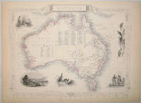
Australia with beautiful Vignettes and illustrations of Natives of the Tribe of Bogan, Sydney, Kangaroos, Australian Parrots and Cockatoo, Natives of Australia Felix. The beautiful map shows the whole continent of Australia with Van Diemen's Island (Tasmania). The map lists all the counties in Victoria, New South Wales, South Australia, West Australia.
de Tallis, John / Rapkin, John. (1817 - 1876)
- Usado
- Estado
- Usado
- Cantidad disponible
- 1
- Librería
-
Skibbereen, Ireland
- Precio
-
EUR 380.00EUR 39.00 enviando a USA
Mostrar detalles
Descripción:
1851. London & New York, J & F. Tallis, 1851. Original steel engraving / Vintage map. Drawn and engraved by John Rapkin. Partly hand-coloured. Size of the actual map: 27 cm x 37 cm. Very good condition. John Tallis (7 November 1817 3 June 1876) was an English cartographic publisher. His company, John Tallis and Company, published views, maps and atlases in London from roughly 1838 to 1851. Tallis set up as a publisher with Frederick Tallis in Cripplegate in 1842; the business moved to Smithfield in 1846, and was dissolved in 1849. From 1851 to 1854 Tallis operated as John Tallis and Company. He started The illustrated news of the world and national portrait gallery of eminent personages in 1858, selling it for £1,370 in 1861; it folded in 1863. (Wikipedia) The most important project John Tallis undertook, was the 'Illustrated Atlas' from 1851. The original map we offer here, was part of this exceptional Atlas and all the maps it contained are still today considered as the last reminder of an era…
Leer más Precio
EUR 380.00
EUR 39.00
enviando a USA

¿No has encontrado lo que estabas buscando?
Prueba a añadir esta búsqueda a búsquedas guardadas Cada día se añaden millones de libros a Biblio. Cuando uno de ellos encaje con tu búsqueda, te enviaremos un correo para avisarte. Y lo mejor de todo, ¡es gratis!
Añadir a búsquedas guardadas

¿Eres un lector habitual o un coleccionista de libros?
Únete al Biblioclub y ahorra 10% en cada compra, ¡cada día! Hasta un máximo de 20$ en cada pedido

Responsabilidad social
¿Sabías que desde 2004 Biblio ha destinado sus beneficios a la construcción de 16 bibliotecas públicas en zonas rurales de Latinoamérica?
