Descripción:
London: John Tallis & Co., 1854. Maps. Steel engraved map from the famous Victorian publisher John Tallis, well-known for the attractive vignette views surrounding the maps, which illustrate the peoples & customs of that region. 10 x 13 1/2" plus margins. Attractive decorative border around edge, period outline color, very good condition.
Resultados de búsqueda: southern india
Has buscado:
- Título: southern india
- Autor: tallis john
Resultados: 1 - 8 de 8

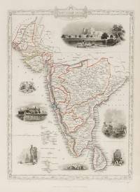
Southern India, antique map with vignette views
de Rapkin, J. Tallis, John
- Usado
- Estado
- Usado
- Cantidad disponible
- 1
- Librería
-
Garrison, New York, United States
- Precio
-
EUR 137.00EUR 7.56 enviando a USA
Mostrar detalles
Precio
EUR 137.00
EUR 7.56
enviando a USA

Southern India, antique map with vignette views
de Rapkin, J. Tallis, John
- Usado
- Estado
- Usado
- Cantidad disponible
- 1
- Librería
-
Garrison, New York, United States
- Precio
-
EUR 137.00EUR 7.56 enviando a USA
Mostrar detalles
Descripción:
London: John Tallis & Co., 1854. Maps. Steel engraved map from the famous Victorian publisher John Tallis, well-known for the attractive vignette views surrounding the maps, which illustrate the peoples & customs of that region. 10 x 13 1/2" plus margins. Attractive decorative border around edge, period outline color, very good condition.
Precio
EUR 137.00
EUR 7.56
enviando a USA

Southern India
de TALLIS, John
- Usado
- Estado
- Usado
- Cantidad disponible
- 1
- Librería
-
New York, New York, United States
- Precio
-
EUR 141.72EUR 5.67 enviando a USA
Mostrar detalles
Descripción:
London: London Printing and Publishing Company, 1851. unbound. Rapkin, J.. Map. Steel engraving with outline hand color. Page measures 14 3/4" x 10 5/8"<br/> <br/> Lovely map of Southern India from Sinde in Pakistan, the Rann of Kutch in the Thar desert, the Deccan Plateau and South to include Sri Lanka. Seven lovely engravings surround the map. Engraved by J. Rapkin, illustrations by A. H. Wray and engraved by J. H. Kernot. John Tallis Jr. (1817-1876) was a London born bookseller who continued the prolific map publishing company started by his father. After a partnership with his brother, Tallis Jr. expanded the business to New York in 1849 as well as Boston, Cincinnati, Rochester, Philadelphia and Baltimore.<br/> <br/>
Precio
EUR 141.72
EUR 5.67
enviando a USA

Southern India.
de RAPKIN, J. [TALLIS, John].
- Usado
- Estado
- Usado
- Cantidad disponible
- 1
- Librería
-
London, London, United Kingdom
- Precio
-
EUR 148.09EUR 10.60 enviando a USA
Mostrar detalles
Descripción:
London & New York: John Tallis & Company. [1851]. 31 x 23 cm. Original outline colour. Steel engraved map. Several vignette scenes, including Shuhur, Jeypoor, Calcutta and Bejapoor. Decorative scrolling and title cartouche around the edges of the image. Generally very good, very occasional spotting outside margin not affecting image. For the Great Exhibition in 1851 John Tallis (1817-1876) worked with engraver John Rapkin (1815-1876) to publish the 'Illustrated World Atlas', whose maps were later re-issued by the London Printing and Publishing Company under the Tallis imprint. Their maps are prized for their wonderful steel-engraved vignettes showing the peoples, customs, architecture, landmarks, flora, and fauna of each country.
Precio
EUR 148.09
EUR 10.60
enviando a USA

Southern India.
de RAPKIN, J. & [TALLIS, John].
- Usado
- Estado
- Usado
- Cantidad disponible
- 1
- Librería
-
London, London, United Kingdom
- Precio
-
EUR 177.70EUR 10.60 enviando a USA
Mostrar detalles
Descripción:
London & New York: John Tallis & Company, [1851-1856].. Original steel engraved map of Southern India. Several vignette scenes, including Shuhur, Jeypoor, Calcutta and Bejapoor. Decorative scrolling and title cartouche around the edges of the image. (Map 22 x 29.5 cm, overall sheet 27.5 x 36 cm). Original outline colour. In excellent condition. For the Great Exhibition in 1851 John Tallis (1817-1876) worked with engraver John Rapkin (1815-1876) to publish the 'Illustrated World Atlas', whose maps were later re-issued by the London Printing and Publishing Company. Their maps are prized for their wonderful steel-engraved vignettes showing the peoples, customs, architecture, landmarks, flora, and fauna of each country.
Precio
EUR 177.70
EUR 10.60
enviando a USA

Southern India.
de RAPKIN, J. & [TALLIS, John].
- Usado
- Estado
- Usado
- Cantidad disponible
- 1
- Librería
-
London, London, United Kingdom
- Precio
-
EUR 177.70EUR 10.60 enviando a USA
Mostrar detalles
Descripción:
The London Printing and Publishing Company, [1851-1856].. Original steel engraved map of Southern India. Several vignette scenes, including Shuhur, Jeypoor, Calcutta and Bejapoor. Decorative scrolling and title cartouche around the edges of the image. (Map 22 x 29.5 cm, overall sheet 27.5 x 36 cm). Original outline colour. Centrefold crease as issued. Very good condition. For the Great Exhibition in 1851 John Tallis (1817-1876) worked with engraver John Rapkin (1815-1876) to publish the 'Illustrated World Atlas', whose maps were later re-issued by the London Printing and Publishing Company. Their maps are prized for their wonderful steel-engraved vignettes showing the peoples, customs, architecture, landmarks, flora, and fauna of each country.
Precio
EUR 177.70
EUR 10.60
enviando a USA

Southern India.
de RAPKIN, J. & [TALLIS, John].
- Usado
- Estado
- Usado
- Cantidad disponible
- 1
- Librería
-
London, London, United Kingdom
- Precio
-
EUR 177.70EUR 10.60 enviando a USA
Mostrar detalles
Descripción:
The London Printing and Publishing Company, [1851-1856].. Original steel engraved map of Southern India. Several vignette scenes by A.H. Wray, including Shuhur, Jeypoor, Calcutta and Bejapoor. Decorative scrolling and title cartouche around the edges of the image. (Map 22 x 29.5 cm, overall sheet 27.5 x 36 cm). Original outline colour. Centrefold crease as issued, an excellent copy. For the Great Exhibition in 1851 John Tallis (1817-1876) worked with engraver John Rapkin (1815-1876) to publish the 'Illustrated World Atlas', whose maps were later re-issued by the London Printing and Publishing Company. Their maps are prized for their wonderful steel-engraved vignettes showing the peoples, customs, architecture, landmarks, flora, and fauna of each country.
Precio
EUR 177.70
EUR 10.60
enviando a USA
Más fotos
Southern India - Including the Presidencies of Bombay and Madras. With Vignettes of Shuhur, Jeypoor, The Government House, Calcutta, and Tomb of Sultan Mahomed Shah, Bejapoor. Also included are Depictions of European soldiers, natives at prayer and the Seal of the East India Company.
de India - Tallis, John / Rapkin, John. (1817 - 1876)
- Usado
- Estado
- Usado
- Cantidad disponible
- 1
- Librería
-
Skibbereen, Ireland
- Precio
-
EUR 245.00EUR 39.00 enviando a USA
Mostrar detalles
Descripción:
1851. London, & New York, John Tallis & Company, 1851. Original steel engraving / Vintage map. Drawn and engraved by John Rapkin. Partly hand-coloured. Illustrations by A.H. Wray and Engraved by J.H. Kernot. Plate Size: 31.8 cm x 25.5 cm. Sheet Size: 37.2 cm x 27.2 cm. Vintage 19th century map in very good condition. Beautiful map of the southern Indian subcontinent, from Sinde at the mouth of the Indus Estuary in the north down through Gujerat, Bejapor and Mysore and down into the Carnatic region in the south. Hydrabad and Circars border the Bay of Bengal. Ceylon is also included in the map as are the Laccadive and Maldive islands in the Indian Ocean. Relief is depicting with hachuring. The major cities such as Bombay, Sernigapatam, and Madras are shown, as are the rivers - including the Godavery and Beema rivers. This was an India dominated by the East India Company, the British joint-stock company that came to rule large areas of India with its private armies, exercising military power and…
Leer más Precio
EUR 245.00
EUR 39.00
enviando a USA

¿No has encontrado lo que estabas buscando?
Prueba a añadir esta búsqueda a búsquedas guardadas Cada día se añaden millones de libros a Biblio. Cuando uno de ellos encaje con tu búsqueda, te enviaremos un correo para avisarte. Y lo mejor de todo, ¡es gratis!
Añadir a búsquedas guardadas

¿Eres un lector habitual o un coleccionista de libros?
Únete al Biblioclub y ahorra 10% en cada compra, ¡cada día! Hasta un máximo de 20$ en cada pedido

Responsabilidad social
¿Sabías que desde 2004 Biblio ha destinado sus beneficios a la construcción de 16 bibliotecas públicas en zonas rurales de Latinoamérica?
