Descripción:
[Tavernier], 1636. Print. Near Fine. Matted and ready for framing. Untrimmed. An exceptional example of a scarce print. A 7 x 9 3/4 sheet professionally matted down to 4 3/4 x 6 3/4 (mat measures 8 1/2 x 10 5/8). Beautiful modern hand coloring added. Labeled 20 in the upper right-hand corner. The print shows a fortification positioned on the north side of a natural waterway, with a small fortification on the opposite side as well. A bridge links the main fortification to the opposite shore, and there appears to be an area for entry by boat along the south wall. This fortress is unique in being completely surrounded by water - the river water acts as a moat between the inner and outer curtains, and also as a moat outside the outer curtain. The only land entries are the south bridge gate and a northern gate that passes through the outer curtain. The shapes of the walls illustrate the star-shaped patterns common to this era, an adaptation made to allow for defensive canonry, and to protect against…
Leer más Resultados de búsqueda: hand colored 1636 print map of
Has buscado:
- Título: hand colored 1636 print map of
- Autor: tassin nicholas
Resultados: 1 - 3 de 3
![Hand Colored 1636 Print, Map of St Iean de lauen [St Jean delaune], from 'Les plans et...](https://d3525k1ryd2155.cloudfront.net/h/841/205/477205841.0.m.1.jpg)
Hand Colored 1636 Print, Map of St Iean de lauen [St Jean delaune], from 'Les plans et profils de toutes les principales villes et lieux considerables de France
de [Tassin, Nicholas]
- Usado
- near fine
- Estado
- Usado - Near Fine
- Cantidad disponible
- 1
- Librería
-
Webster, New York, United States
- Precio
-
EUR 28.36EUR 5.85 enviando a USA
Mostrar detalles
Precio
EUR 28.36
EUR 5.85
enviando a USA
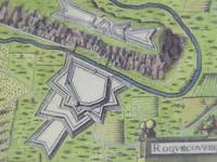
Hand Colored 1636 Print, Map of Roquecourbe, from 'Les plans et profils de toutes les principales villes et lieux considerables de France
de [Tassin, Nicholas]
- Usado
- near fine
- Estado
- Usado - Near Fine
- Cantidad disponible
- 1
- Librería
-
Webster, New York, United States
- Precio
-
EUR 28.36EUR 5.85 enviando a USA
Mostrar detalles
Descripción:
[Tavernier], 1636. Print. Near Fine. Matted and ready for framing. Untrimmed. An exceptional example of a scarce print. A 7 x 9 3/4 sheet professionally matted down to 4 3/4 x 6 3/4 (mat measures 8 1/2 x 10 5/8). Beautiful modern hand coloring added. Labeled 44 in the upper right-hand corner. Roquecourbe is a region in south central France. The print shows a unique two-part fortification positioned on both sides of a natural waterway. The larger part borders on the south, with a bridge gatehouse leading to the main road. The northern portion sits atop a plateau linked to the main road by a winding stair. Attacking forces attempting to storm the main gate would be caught in a pincer attack between the two fortresses. The limited space between river and plateau would put them at even more severe a disadvantage by reducing troops to a narrow column. The shapes of the walls illustrate the star-shaped patterns common to this era, an adaptation made to allow for defensive canonry, and to protect against…
Leer más Precio
EUR 28.36
EUR 5.85
enviando a USA
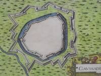
Hand Colored 1636 Print, Map of Caussade, from 'Les plans et profils de toutes les principales villes et lieux considerables de France
de [Tassin, Nicholas]
- Usado
- near fine
- Estado
- Usado - Near Fine
- Cantidad disponible
- 1
- Librería
-
Webster, New York, United States
- Precio
-
EUR 28.36EUR 5.85 enviando a USA
Mostrar detalles
Descripción:
[Tavernier], 1636. Print. Near Fine. Matted and ready for framing. Untrimmed. An exceptional example of a scarce print. A 7 x 9 3/4 sheet professionally matted down to 4 3/4 x 6 3/4 (mat measures 8 1/2 x 10 5/8). Beautiful modern hand coloring added. Labeled 15 in the upper right-hand corner. Caussade is a region in southwestern France. The print shows a fortification positioned along a waterway which runs northwest to southeast along the southwest wall. The only entrance is at the northeast corner. There are two curtain walls, the inner one surrounded by a moat. The shapes of the walls illustrate the star-shaped patterns common to this era, an adaptation made to allow for defensive canonry, and to protect against siege artillery.
Precio
EUR 28.36
EUR 5.85
enviando a USA

¿No has encontrado lo que estabas buscando?
Prueba a añadir esta búsqueda a búsquedas guardadas Cada día se añaden millones de libros a Biblio. Cuando uno de ellos encaje con tu búsqueda, te enviaremos un correo para avisarte. Y lo mejor de todo, ¡es gratis!
Añadir a búsquedas guardadas

¿Eres un lector habitual o un coleccionista de libros?
Únete al Biblioclub y ahorra 10% en cada compra, ¡cada día! Hasta un máximo de 20$ en cada pedido

Responsabilidad social
¿Sabías que desde 2004 Biblio ha destinado sus beneficios a la construcción de 16 bibliotecas públicas en zonas rurales de Latinoamérica?
