Descripción:
RELATIONI UNIVERSALI DI GIOVANNI BOTERO BENESE., 1598. Giovanni Botero (1533-1617) was Secretary to the Duke of Savoy when he compiled his Relationi Universali; "this political and geographical description of the different countries of the world was very successful and translated into a number of languages" (Burden), including English (London 1603). Copper engraving. Uncoloured. Fine condition. map on sheet 20 x 15 cm. Map in Latin; accompanying text in Italian. Size: 11 x 8 cm. (4½ x 3 inches)
Resultados de búsqueda: Títulos que empiezan por C de Peter Harrington
Has buscado:
- Bookseller inventory: Peter Harrington (titles starting with C)
- Librería: Peter Harrington
Resultados: 1 - 20 de 1075
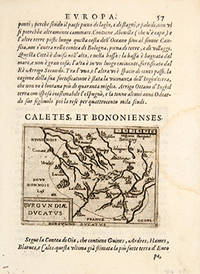
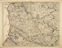
CALETTES, ET BONONIENSES. BURGUNDIAE DUCATUS
de BOTERO, Giovanni. Engraved by Ortelius.
- Usado
- Estado
- Usado
- Cantidad disponible
- 1
- Librería
-
London, United Kingdom
- Precio
-
EUR 71.00EUR 14.20 enviando a USA
Mostrar detalles
Precio
EUR 71.00
EUR 14.20
enviando a USA
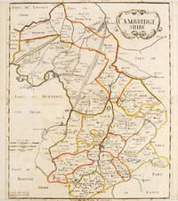
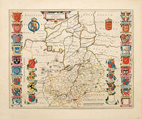
CAMBRIDGESHIRE.
de MORDEN, Robert.
- Usado
- First
- Estado
- Usado
- Cantidad disponible
- 1
- Librería
-
London, United Kingdom
- Precio
-
EUR 260.35EUR 14.20 enviando a USA
Mostrar detalles
Descripción:
Gibson's edition of Camden's Britannia, first Morden edition. Abel Swale & John Churchill., 1695.. Beautiful map of Cambridgeshire, coloured by the hundreds of the county. Cartouche at upper right, scales at lower left. The 1695 edition of Camden's Britannia was the first edition to contain Robert Morden's beautiful county maps. Morden went to considerable trouble to make them as accurate as possible, and they were the first county maps to include roads. Copper engraving. Original outline colour. Fine condition. Printed on thin paper, narrow margins. Size: 36 x 43 cm. (14 x 17 inches). Smith: Antique Maps of Britain, 80(i).
Precio
EUR 260.35
EUR 14.20
enviando a USA

CANADA, NEW BRUNSWICK AND NOVA SCOTIA: 36.
de Artist: DOWER, John.Engraved by Dower, John.
- Usado
- Estado
- Usado
- Cantidad disponible
- 1
- Librería
-
London, United Kingdom
- Precio
-
EUR 207.10EUR 14.20 enviando a USA
Mostrar detalles
Descripción:
London., 1835. An accurate and up to date map of Canada. Published in A New General Atlas of the World by Henry Teesdale & Co. With coloured margins of countries. Shows cities, place names, roads, rivers, lakes, and islands. Copper engraving. Original colour. Very good condition. Size: 35 x 43 cm.
Precio
EUR 207.10
EUR 14.20
enviando a USA
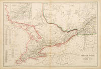
CANADA WEST, AND PART OF CANADA EAST: LXIX.
de LOWRY, Joseph Wilson
- Usado
- Estado
- Usado
- Cantidad disponible
- 1
- Librería
-
London, United Kingdom
- Precio
-
EUR 195.26EUR 14.20 enviando a USA
Mostrar detalles
Descripción:
Glasgow, Edinburgh & London., 1860. Detailed map of West Canada. A list of the counties and districts of Canada West and East is included. An inset of Montreal is located at top left. Published in The Imperial Atlas of Modern Geography by Blackie & Son. Copper engraving. Original outline colour. Good condition. Size: 50 x 34 cm.
Precio
EUR 195.26
EUR 14.20
enviando a USA
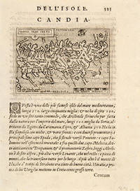
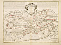
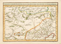
CANDIA OLIM CRETA
de BOTERO, Giovanni.
- Usado
- Estado
- Usado
- Cantidad disponible
- 1
- Librería
-
London, United Kingdom
- Precio
-
EUR 130.17EUR 14.20 enviando a USA
Mostrar detalles
Descripción:
RELATIONI UNIVERSALI DI GIOVANNI BOTERO BENESE., 1598. Giovanni Botero (1533-1617) was Secretary to the Duke of Savoy when he compiled his Relationi Universali; "this political and geographical description of the different countries of the world was very successful and translated into a number of languages" (Burden), including English (London 1603). Copper engraving. Uncoloured. Fine condition. map on sheet 20 x 15 cm. Map in Latin; accompanying text in Italian. Size: 11 x 8 cm. (4½ x 3 inches)
Precio
EUR 130.17
EUR 14.20
enviando a USA
CANTABRIGIENSIS COMITATUS CAMBRIDGE SHIRE: Cambridgeshire
de SCHENK, Pieter & VALK, Gerard
- Usado
- Estado
- Usado
- Cantidad disponible
- 1
- Librería
-
London, United Kingdom
- Precio
-
EUR 946.72EUR 14.20 enviando a USA
Mostrar detalles
Descripción:
Atlas Anglois. D Mortier., 1715. A beautiful map of the county, rich with heraldry. Shows the bordering counties Copper engraving. Original colour. Fine condition, good margins. Size: 52 x 42 cm. (20½ x 16½ inches).
Precio
EUR 946.72
EUR 14.20
enviando a USA
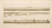
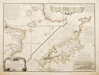
CAPE BLANCO bearing S.W. distant 5 leagues/ CAPE BLANCO on the coast of PATAGONIA: Bearing SW distant 4 leagues.: Pl. 3
de ANSON, George Anson, Baron.
- Usado
- Estado
- Usado
- Cantidad disponible
- 1
- Librería
-
London, United Kingdom
- Precio
-
EUR 165.68EUR 14.20 enviando a USA
Mostrar detalles
Descripción:
Voyage Round the World., 1748. Two simple coastal views of Cape Blanco in Patagonia in the extreme south of South America. Ships are seen at anchor. Copper engraving. Uncoloured. In fine condition. Minor worming not affecting the engraved image. Size: 47.5 x 21 cm.
Precio
EUR 165.68
EUR 14.20
enviando a USA

CAPE COLONY
de RAPKIN, John.
- Usado
- Estado
- Usado
- Cantidad disponible
- 1
- Librería
-
London, United Kingdom
- Precio
-
EUR 213.01EUR 14.20 enviando a USA
Mostrar detalles
Descripción:
London and New York., 1850. A highly decorative map for the period with vignettes showing towns and local scenes, the whole enclosed in an elegant border. Published in 'The Illustrated Atlas and Modern History of the World Geograohical, Political, Commercial & Statistical' by John Tallis & Company. Size: 320 x 250 mm. Steel engraving. Original outline colour with later additions. Fine condition.
Precio
EUR 213.01
EUR 14.20
enviando a USA
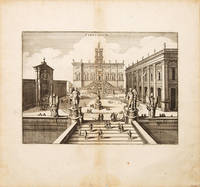
CAPITOLIUM.
de MERIAN, Matthew.
- Usado
- Estado
- Usado
- Cantidad disponible
- 1
- Librería
-
London, United Kingdom
- Precio
-
EUR 207.10EUR 14.20 enviando a USA
Mostrar detalles
Descripción:
J.L. Gottfried's Archontologica Cosmica., 1649.. An attractive view of Capitolium in Rome by the famed Swiss engraver, Matthew Merian. This very detailed and beautifully designed view shows the stepsl leading up to the Capitolium, the famous statue of Marcus Aurelius, and the palazzio behind. Citizens wandering around the steps give an idea of the scale of the buildings and statues. Copper engraving. Uncoloured. Fine condition. Size: 27 x 20 cm. (10½ x 8 inches).
Precio
EUR 207.10
EUR 14.20
enviando a USA
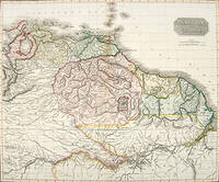
CARACCAS and GUIANA.
de THOMSON, John.
- Usado
- Estado
- Usado
- Cantidad disponible
- 1
- Librería
-
London, United Kingdom
- Precio
-
EUR 414.19EUR 14.20 enviando a USA
Mostrar detalles
Descripción:
Edinburgh: , 1827. A very handsome and impressive map of north-eastern South America from Lake Maracaibo in Venezuela to the mouth of the Amazon. Like many maps of the time it shows the non-existent 'Lake Parima', between the Orinoco and Amazon rivers. The New General Atlas was one of the most accurate and best produced atlases of the day. Copper engraving. Original outline colour. Fine condition. Size: 60 x 50 cm.
Precio
EUR 414.19
EUR 14.20
enviando a USA

CARTA DA NAVIGARE.: World Map for mariners.
de PORCACCHI DA CASTIGLIONE, Thomaso.
- Usado
- Estado
- Usado
- Cantidad disponible
- 1
- Librería
-
London, United Kingdom
- Precio
-
EUR 568.03EUR 14.20 enviando a USA
Mostrar detalles
Descripción:
Venice: L'Isole Piu Famoso del Mondo. Simon Galignani., 1590. Attractive world map, a mariner's map with rhumb lines emanating from 16 points. The maps for this atlas were engraved by Girolamo Porro from Padua, and are set within a page of text, with engraved headpiece and decorated initial. There were many editions of this popular atlas between 1576 and 1713. Size:197 x 297 mm. Copper engraving. Hand coloured. Closed tear on lower margin of leaf not affecting map. Very good condition. Moreland and Bannister, p.68
Precio
EUR 568.03
EUR 14.20
enviando a USA
CARTE DARTOIS ET DES ENVIRONS,: ou lon voit le Resort du Conseil Provincial d'Artois
de DELISLE, Guillaume
- Usado
- Estado
- Usado
- Cantidad disponible
- 1
- Librería
-
London, United Kingdom
- Precio
-
EUR 230.76EUR 14.20 enviando a USA
Mostrar detalles
Descripción:
Paris., c1730. A highly detailed map showing hills, forests, rivers, cities, fortifications, villages, Abbeys and roads. Copper engraving. Original outline colour. Very good condition. Size: 62.5 x 48.5 cm.
Precio
EUR 230.76
EUR 14.20
enviando a USA

CARTE DE FRANCE divisee Suivant Les Quatre Departements de messieurs les Secretaires D'Etat.
de DELISLE, Guillaume
- Usado
- Estado
- Usado
- Cantidad disponible
- 1
- Librería
-
London, United Kingdom
- Precio
-
EUR 236.68EUR 14.20 enviando a USA
Mostrar detalles
Descripción:
Atlas Geographique. Quay de l'Horloge., 1731.. Delisle was an important French cartographer of the early 18th century. He held the position of First Royal Geographer to the King. A detailed map of France showing the relief of the land and the various regions. A scale lower left shows the different distances between different areas. Germany is shown in the north east and the coast of southern England in the north west. The Mediterranean is in the south east and northern Spain southern west corner. Copper engraving. Original outline colour. Size: 62 x 49 cm. Very good condition
Precio
EUR 236.68
EUR 14.20
enviando a USA
CARTE DE LA SOUVERAINETÉ DE NEUCHATEL ET VALLANGIN: Dressée sur les Memoires des Snr D. F. de Merveilleux D.M.oin Rectifiés par les Observations de l'Academie Royale des Sciences Dediée A Monsieur de la Venerable Classes et Compagnie des Pasteura du Compté de Neuchatel
de DE LISLE, G.
- Usado
- Estado
- Usado
- Cantidad disponible
- 1
- Librería
-
London, United Kingdom
- Precio
-
EUR 414.19EUR 14.20 enviando a USA
Mostrar detalles
Descripción:
Paris., c.1713. A map of the capital of the Swiss canton of Neuchâtel on Lake Neuchâtel. The map includes ruined castles, battlefields and mountainous areas all explained by a key lower left. A note stretching across the top of the map explains about the county of Neuchatel; the state and how it is governed. Atlas de Geographie. Copper engraving. Original colour. Very good condition - slight browning to centrefold and minor foxing. Size: 64.5 x 49 cm.
Precio
EUR 414.19
EUR 14.20
enviando a USA
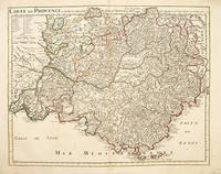
CARTE DE PROVENCE et des Terres Adjacentes: Map of Provence.
de DELISLE, Guillaume
- Usado
- Estado
- Usado
- Cantidad disponible
- 1
- Librería
-
London, United Kingdom
- Precio
-
EUR 591.70EUR 14.20 enviando a USA
Mostrar detalles
Descripción:
Paris. , c1715. Delisle was an important French cartographer of the early 18th century. He held the position of First Royal Geographer to the King. A is a lovely map of Provence in southern France. It is extremely detailed with the various dioceses marked and the surrounding Bishopric of Arles and The Comtat Venaissin to the north. A key top left explains the symbols and abbreviations. The Mediterranean sea and the Golf of Lyon and Genes are in the south. From the Atlas Geographique. Copper engraving. Original outline colour. Very good condition - some very light brown marks on image. Size: 61 x 48.4 cm.
Precio
EUR 591.70
EUR 14.20
enviando a USA

CARTE DES COURONES DU NORD Dediee AU TRES PUISSANT ET TRES INVINCIBLE PRINCE CHARLES XII ROY DE SUEDE DES GOTS ET DES VANDALES (pair): A map of the Kingdoms of the north, dedicated to the powerful and invincible Prince Charles XII, King of Sweden, the Goths and the Vandals.
de DELISLE, Guillaume
- Usado
- Estado
- Usado
- Cantidad disponible
- 1
- Librería
-
London, United Kingdom
- Precio
-
EUR 680.46EUR 14.20 enviando a USA
Mostrar detalles
Descripción:
Atlas de Geographie. Guilluame Delisle, Quai de l'Horloge., [c.1742]. Delisle was an important French cartographer of the early 18th century. He held the position of First Royal Geograp-her to the King. Two attractive maps of Scandanavia. The first one showing the northern regions of Norway, Sweden, including the islands and fjords, Finland and part of western Russia. A grandiose cartouche upper left. The second map has an interesting perspective showing the Baltic Sea in the centre and the lower parts of Norway, Sweden, Finland and all of Denmark to the west whilst northern Poland and Eastern states including Estonia are shown in the east. Copper engraving. Original outline colour. Overall both in very good condition. Some minor darker patches in margin corners but not affecting image. Minor foxing on images. Size: 62 x 45.3 cm. (24½ x 18 inches)
Precio
EUR 680.46
EUR 14.20
enviando a USA
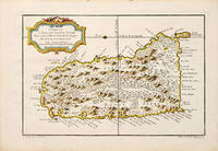
CARTE DE L'ISLE DE SAINTE LUCIE.: [St Lucia.]
de BELLIN, Jacques Nicolas.
- Usado
- Estado
- Usado
- Cantidad disponible
- 1
- Librería
-
London, United Kingdom
- Precio
-
EUR 171.59EUR 14.20 enviando a USA
Mostrar detalles
Descripción:
Le Petit Atlas Maritime., 1764. This map depicts the Caribbean island of St. Lucia or St. Lucie. It shows the island in some detail with references to its many towns, forts, and ports. Decorative title cartouche. This map was published in 1764 for Bellin's Le Petit Atlas Maritime. Copper engraving. Hand coloured. Very good condition. Size: 320 x 210 mm. (12½ x 8½ inches)
Precio
EUR 171.59
EUR 14.20
enviando a USA

CARTE DE L'ISLE DE SAINTE LUCIE.: [St Lucia.]
de BELLIN, Jacques Nicolas.
- Usado
- Estado
- Usado
- Cantidad disponible
- 1
- Librería
-
London, United Kingdom
- Precio
-
EUR 171.59EUR 14.20 enviando a USA
Mostrar detalles
Descripción:
Le Petit Atlas Maritime., 1764. This map depicts the Caribbean island of St. Lucia or St. Lucie. It shows the island in some detail with references to its many towns, forts, and ports. Decorative title cartouche. This map was published in 1764 for Bellin's Le Petit Atlas Maritime. Copper engraving. Hand coloured. Very good condition.
Precio
EUR 171.59
EUR 14.20
enviando a USA
CARTE DE LA PARTIE DE L'OCEAN: Vers l'Equateur entre les Cotes D'AFRIQUE et D'AMERIQUE Où la Situation des Isles, Bancs, et Vigies, montre qu'elles peuvent être soit la cause des variétés observées dans les Courants de ces Mers; Dressées par Philippe Buache Premier Géographe de
de BUACHE, Philippe, 1700-1773
- Usado
- Estado
- Usado
- Cantidad disponible
- 1
- Librería
-
London, United Kingdom
- Precio
-
EUR 443.78EUR 14.20 enviando a USA
Mostrar detalles
Descripción:
Atlas de Geographie., Sept 1737.. An interesting geo-hydrographic map of the Atlantic Ocean and its islands. It is divided into two with one side showing the Atlantic Ocean and the coasts of Africa and Brazil and the other side a detailed examination of the archipelago of Fernando de Noronha. A note top left explains the purpose of the map, which in brief is to give an idea of the variety of islands in the Atlantic Ocean. Another note top right explains a little about the cartographers and expedition members. Another explains about an embankment between islands on the archipelago. A cartouche top right contains a cross-section diagram of what is below sea level. Another below sea-level cross-section shows the particulars of Fernando de Noronha lower right corner. Copper engraving. Original colour. Very good condition - slight dark patches to lower corners and repair to lower left margin. Some offsetting. Size: 65 x 49.5 cm. (25½ x 19½ inches)
Precio
EUR 443.78
EUR 14.20
enviando a USA
CARTE DE LA TARTARIE OCCIDENTALE Pour servir a l'Histoire Generale des Voyages.: Tome 8, Page 375.
de BELLIN, Jacques Nicolas
- Usado
- Estado
- Usado
- Cantidad disponible
- 1
- Librería
-
London, United Kingdom
- Precio
-
EUR 112.42EUR 14.20 enviando a USA
Mostrar detalles
Descripción:
Histoire Generale des Voyages., 1749. Bellin was appointed hydrographer (chief cartographer) to the French Navy upon the creation of France's hydrographic office, the Dépôt des cartes et plans de la Marine.Over a 50 year career, he produced a large number of maps and charts. The accuracy of Bellin's charts ensured that they were in use for many years. Copper engraving. Hand coloured. Very good condition; some offsetting. Size: 32.5 x 23.5 cm. (13 x 9½ inches)
Precio
EUR 112.42
EUR 14.20
enviando a USA

¿No has encontrado lo que estabas buscando?
Prueba a añadir esta búsqueda a búsquedas guardadas Cada día se añaden millones de libros a Biblio. Cuando uno de ellos encaje con tu búsqueda, te enviaremos un correo para avisarte. Y lo mejor de todo, ¡es gratis!
Añadir a búsquedas guardadas

¿Eres un lector habitual o un coleccionista de libros?
Únete al Biblioclub y ahorra 10% en cada compra, ¡cada día! Hasta un máximo de 20$ en cada pedido

Responsabilidad social
¿Sabías que desde 2004 Biblio ha destinado sus beneficios a la construcción de 16 bibliotecas públicas en zonas rurales de Latinoamérica?
