Descripción:
London: Puffin Books,, 2004. First edition, first impression, of this alphabetical primer to Dahl's life and books by Wendy Cooling, the founder of the children's reading charity Bookstart. Square octavo. Original dark purple boards, spine lettered in silver, red endpapers. With dust jacket. Line drawings by Quentin Blake. Unclipped jacket spine partially sunned, panels and flaps bright, light edge creasing: a fine copy in very good jacket.
Resultados de búsqueda: Títulos que empiezan por D de Peter Harrington
Has buscado:
- Bookseller inventory: Peter Harrington (titles starting with D)
- Librería: Peter Harrington
Resultados: 1 - 20 de 531

Más fotos
D is for Dahl.: A Gloriumptious A-Z Guide to the World of Roald Dahl.
de DAHL, Roald - COOLING, Wendy.
- Usado
- Tapa dura
- First
- Estado
- Usado
- Encuadernación
- Hardcover
- Cantidad disponible
- 1
- Librería
-
London, United Kingdom
- Precio
-
EUR 94.67EUR 14.20 enviando a USA
Mostrar detalles
Precio
EUR 94.67
EUR 14.20
enviando a USA

DAME DE HONG-KONG (Chine)
de PORTRAIT.
- Usado
- Estado
- Usado
- Cantidad disponible
- 1
- Librería
-
London, United Kingdom
- Precio
-
EUR 76.92EUR 14.20 enviando a USA
Mostrar detalles
Descripción:
c1860. Lithograph. Printed colour. Very good condition. Size: 19 x 28.5 cm
Precio
EUR 76.92
EUR 14.20
enviando a USA

DANEMARK SUEDE et NORWEGE par La Pie 1809
de TARDIEU, J.B.
- Usado
- Estado
- Usado
- Cantidad disponible
- 1
- Librería
-
London, United Kingdom
- Precio
-
EUR 189.34EUR 14.20 enviando a USA
Mostrar detalles
Descripción:
Precis de la Geographie Universelle by Malte Brun., 1810. Clear and detailed engraving of Scandinavia, with inset maps of Iceland and the Faroe Islands. Illustrated cartouche at lower right showing title on a rock in a forest. Two scales below Copper engraving. Later colour. Fine condition Size: 30 x 21 cm. (12 x 8½ inches)
Precio
EUR 189.34
EUR 14.20
enviando a USA

Más fotos
D'Arcussia's Falconry.
de ARCUSSIA, Charles d'.; LOFT, John (trans.)
- Usado
- Tapa dura
- Firmado
- Estado
- Usado
- Encuadernación
- Hardcover
- Cantidad disponible
- 1
- Librería
-
London, United Kingdom
- Precio
-
EUR 414.19EUR 14.20 enviando a USA
Mostrar detalles
Descripción:
Louth, Lincolnshire: [privately printed,], 2003. First and only edition in English, first impression, signed and dated by the translator on the half-title. D'Arcussia's La Fauconnerie was first published in 1599, and Loft's translation is based on the 1643 edition. Nature writer and ornithologist Stephen Bodio writes that Loft's "work on a never-translated manual by d'Arcussia, a 17th-century Provençal professional, makes accessible the most interesting falconry book between Frederic II and the late 19th-century Art and Practice of Hawking. It enables English speakers, whose idea of falconry can be a bit narrow, to see a western falconry culture with much eastern influence, one that Emperor Frederic would have recognized" (Bodio). Octavo. Original green boards, spine lettered in gilt. With dust jacket. Frontispiece and numerous illustrations to the text, many full-page. Stain to fore edge; jacket flaps without price, as issued: a very good copy in fine jacket. Stephen Bodio, "Two Falconers", 22…
Leer más Precio
EUR 414.19
EUR 14.20
enviando a USA

DENMARK and the Duchies.
de SWANSTON, George H.
- Usado
- Estado
- Usado
- Cantidad disponible
- 1
- Librería
-
London, United Kingdom
- Precio
-
EUR 100.59EUR 14.20 enviando a USA
Mostrar detalles
Descripción:
Gazetteer of the World. A. Fullarton & Co., 1860. A detailed map of Denmark with five inset maps of Danish foreign territories of Iceland Santa Cruz, the Virgin Islands, Faroe Islands and Bornholm. Lithograph. Later colour. Fine condition. Size: 40 x 53cm. (15 x 21 inches).
Precio
EUR 100.59
EUR 14.20
enviando a USA
![DENMARK. [inset maps:] Iceland. Feroe Islands](https://d3525k1ryd2155.cloudfront.net/h/158/200/319200158.0.m.jpg)
DENMARK. [inset maps:] Iceland. Feroe Islands
de THOMSON, John
- Usado
- Estado
- Usado
- Cantidad disponible
- 1
- Librería
-
London, United Kingdom
- Precio
-
EUR 236.68EUR 14.20 enviando a USA
Mostrar detalles
Descripción:
A New General Atlas. Edinburgh: Printed by Ben Stark for John Thomson., 1827. Attractive map of Denmark with two insets to the left. Title at top right with threescales underneath The New General Atlas was one of the most accurate and best produced atlases of the day. John Thomson's 'County Atlas of Scotland' is generally considered the finest of its kind. Copper engraving. Original outline colour. Fine condition. Size: 59 x 50 cm. (23 x 19½ inches).
Precio
EUR 236.68
EUR 14.20
enviando a USA

DENMARK including Schleswig & Holstein.
de Lowry, J. W.
- Usado
- Estado
- Usado
- Cantidad disponible
- 1
- Librería
-
London, United Kingdom
- Precio
-
EUR 112.42EUR 14.20 enviando a USA
Mostrar detalles
Descripción:
The Dispatch Atlas. Weekly Dispatch., 1858-63. A detailed map of Denmark with an inset map of Bornholm at lower right. Lithograph. Later colour. Fine condition. Size: 42.5 x 59 cm. (16½ x 23 inches).
Precio
EUR 112.42
EUR 14.20
enviando a USA

DENMARK AND PART OF NORWAY
de Engraved by J & C Walker
- Usado
- Estado
- Usado
- Cantidad disponible
- 1
- Librería
-
London, United Kingdom
- Precio
-
EUR 177.51EUR 14.20 enviando a USA
Mostrar detalles
Descripción:
London: Society for the Diffusion of Useful Knowledge,, 1844. Benevolent societies with the intention to disseminate knowledge were a distinguishing feature of the Victorian age. SDUK was founded in 1827 by John, Earl Russell and Henry Brougham, later Lord Chancellor of England. The Society published books that were deemed to be of high educational worth but with an affordable price. These fine steel engravings have original hand colouring and are often embellished with vignettes and comparisons of the height of the principal buildings of the city. Extent: south coast of Norway and Denmark. Very good condition. Size: 31 x 38.5 cm. (12 x 15 inches)
Precio
EUR 177.51
EUR 14.20
enviando a USA

DENMARK.
de CARY, John.
- Usado
- Estado
- Usado
- Cantidad disponible
- 1
- Librería
-
London, United Kingdom
- Precio
-
EUR 153.84EUR 14.20 enviando a USA
Mostrar detalles
Descripción:
New Universal Atlas., 1808.. This beautiful map, accurate and concise, is from John Cary's Universal Atlas. This was a compact version of his General Atlas, and shows the high standard of design, printing, and geographical accuracy that has led many to consider Cary as the finest of English map-makers. Copper engraving. Original colour. Fine condition. Size: 23 x 28 cm. (9 x 11 inches).
Precio
EUR 153.84
EUR 14.20
enviando a USA

DENMARK.
de ARROWSMITH, John.
- Usado
- Estado
- Usado
- Cantidad disponible
- 1
- Librería
-
London, United Kingdom
- Precio
-
EUR 142.01EUR 14.20 enviando a USA
Mostrar detalles
Descripción:
The London Atlas of Universal Geography., 1834. Attractive map of Denmark, with inset of Iceland at top right. John Arrowsmith constantly revised and improved his popular London Atlas and it ran to many editions. Copper engraving. Original colour. Fine condition. Size: 48 x 59 cm. (19 x 23 inches).
Precio
EUR 142.01
EUR 14.20
enviando a USA

DENMARK WITH SCHLESWIG & HOLSTEIN. and ICELAND. and GREENLAND WITH THE DANISH COLONIES. ICELAND, AND THE FEROE ISLANDS.: XIII, XIV.
de Engraved by LOWRY, Joseph William
- Usado
- Estado
- Usado
- Cantidad disponible
- 1
- Librería
-
London, United Kingdom
- Precio
-
EUR 130.17EUR 14.20 enviando a USA
Mostrar detalles
Descripción:
THE IMPERIAL ATLAS OF MODERN GEOGRAPHY; AN EXTENSIVE SERIES OF MAPS, EMBRACING THE MOST RECENT DISCOVERIES AND THE LATEST POLITICAL DIVISIONS OF TERRITORY IN ALL PARTS OF THE WORLD. Walter Grahame Blackie., 1860. Three detailed maps of Denmark and the Danish territories of Iceland and Greenland on one sheet. On the map of Greenland, a small inset is included showing the Feroe Islands. Copper engraving. Original outline colour. Good condition. Size: 49 x 33.5 cm. (19½ x 13 inches)
Precio
EUR 130.17
EUR 14.20
enviando a USA

DENMARK.
de SMITH, Charles.
- Usado
- Estado
- Usado
- Cantidad disponible
- 1
- Librería
-
London, United Kingdom
- Precio
-
EUR 88.76EUR 14.20 enviando a USA
Mostrar detalles
Descripción:
New General Atlas., 1808.. Copper engraving. Original colour. Fine condition. Size: 26.5 x 35.5 cm. (10½ x 14 inches).
Precio
EUR 88.76
EUR 14.20
enviando a USA

DESCRITTIONE DEL MAPPA MONDO.
de PORCACCHI DA CASTIGLIONE, Thomaso.
- Usado
- Estado
- Usado
- Cantidad disponible
- 1
- Librería
-
London, United Kingdom
- Precio
-
EUR 710.04EUR 14.20 enviando a USA
Mostrar detalles
Descripción:
Venice: L'Isole Piu Famoso del Mondo. Simon Galignani., 1590. Oval map of the world. The maps for this atlas were engraved by Girolamo Porro from Padua, and are set within a page of text, with engraved headpiece and decorated initial. There were many editions of this popular atlas between 1576 and 1713. Size:197 x 297 mm. Copper engraving. Hand coloured. A fine, crisp impression. Fine condition. Moreland and Bannister, p.68
Precio
EUR 710.04
EUR 14.20
enviando a USA

DIOECESIS COLONIENSIS
de QUAD, Matthias.
- Usado
- Estado
- Usado
- Cantidad disponible
- 1
- Librería
-
London, United Kingdom
- Precio
-
EUR 355.02EUR 14.20 enviando a USA
Mostrar detalles
Descripción:
Frankfurt., c1608. Handsome map of the region around Cologne, South Germany. Title cartouche at bottom right corner. Vignette with a portrait of an archbishop of Cologne at top centre. Latin text on verso. Matthaus Quad was a German cartographer based in Cologne, which, at the time was the centre for German cartography. This map is from his Fascilus Geographicus. It was printed by Johannes Bussemacher. Copper engraving. Hand coloured. Very good condition; some offsetting; good margins. Size: 30.5 x 22.5 cm.
Precio
EUR 355.02
EUR 14.20
enviando a USA
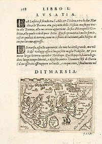
DITMARSIA. THIETMARSIA HOLSATICAEREG: THIETMARSIA Germany.
de BOTERO, Giovanni. Engraved by Ortelius.
- Usado
- Estado
- Usado
- Cantidad disponible
- 1
- Librería
-
London, United Kingdom
- Precio
-
EUR 94.67EUR 14.20 enviando a USA
Mostrar detalles
Descripción:
RELATIONI UNIVERSALI DI GIOVANNI BOTERO BENESE., 1598. Giovanni Botero (1533-1617) was Secretary to the Duke of Savoy when he compiled his Relationi Universali; "this political and geographical description of the different countries of the world was very successful and translated into a number of languages" (Burden), including English (London 1603). Copper engraving. Uncoloured. Fine condition. map on sheet 20 x 15 cm. Map in Latin; accompanying text in Italian. Size: 11 x 8 cm. (4½ x 3 inches)
Precio
EUR 94.67
EUR 14.20
enviando a USA

DIVISION DU GLOBE TERRESTRE.
de CHIQUET, Jacques.
- Usado
- Estado
- Usado
- Cantidad disponible
- 1
- Librería
-
London, United Kingdom
- Precio
-
EUR 171.59EUR 14.20 enviando a USA
Mostrar detalles
Descripción:
La Nouveau et Curieux Atlas Geographique et Historique., [c.1719]. This plate shows two hemispheres, showing the equator, tropics and polar zones of the world, in the cusps and corners there are six smaller diagrams showing 'Disposition des Parallels' and 'Explication des Zones' etc. In the early eighteenth century, French cartography overtook the Dutch in terms of accuracy and design. Chiquet's delightful Nouveau et Curieux Atlas was typical product of the time. Size: 212 x 165 mm. (8½ x 6½ inches). Copper engraving. Original colour with later additions. Fine condition, good margins. Moreland and Bannister, p.132
Precio
EUR 171.59
EUR 14.20
enviando a USA

D'Jami ou Mosquee Cathedrale, de Hhacen; au Caire. Vue de la principale porte de la Mosquee: Plate 66, vol.3.
de CASSAS, Louis François.
- Usado
- First
- Estado
- Usado
- Cantidad disponible
- 1
- Librería
-
London, United Kingdom
- Precio
-
EUR 514.78EUR 14.20 enviando a USA
Mostrar detalles
Descripción:
Voyage Pittoresque de la Syrie, de la Phoenicie, de la Palestine, et de la Basse Egypte., 1799-1800. Beautiful print of a large city mosque in Cairo with citizens and camels strolling by in the streets. Louis-François Cassas was one of the best French printmakers of the eighteenth century, His Voyage Pittoresque de la Syrie, de la Phoenicie, de la Palestine, et de la Basse-Egypte is perhaps the finest eighteenth century illustrated book on the Middle East. Cassas accompanied Choiseul-Gouffier on his embassy to Istanbul in 1784 but remained there only a few weeks. From the end of 1784 to 1787 he travelled in the Levant, Syria and Egypt at Choiseul-Gouffier's expense, making more than 300 drawings. His drawings of Troad were engraved for volume II of Choiseul-Gouffier's 'Voyage Pittoresque'. His original drawings remained in family hands for many y ears, but were sold at auction in 1878. The drawings include studies of costumes, architectural pieces, monuments, views, scenes from daily life and…
Leer más Precio
EUR 514.78
EUR 14.20
enviando a USA

D'Jami ou Mosquée Cathédrale, de Hhacan; au Caire. Vuë générale de la Mosquée.
de CASSAS, Louis Francois.
- Usado
- First
- Estado
- Usado
- Cantidad disponible
- 1
- Librería
-
London, United Kingdom
- Precio
-
EUR 514.78EUR 14.20 enviando a USA
Mostrar detalles
Descripción:
Voyage Pittoresque de la Syrie, de la Phoenicie, de la Palestine, et de la Basse Egypte., 1799-1800. Magnificent engraving of the mosque of Hassan in Cairo. Louis-François Cassas was one of the best French printmakers of the eighteenth century. His Voyage Pittoresque de la Syrie, de la Phoenicie, de la Palestine, et de la Basse-Egypte is perhaps the finest eighteenth century illustrated book on the Middle East. Cassas accompanied Choiseul-Gouffier on his embassy to Istanbul in 1784 but remained there only a few weeks. From the end of 1784 to 1787 he travelled in the Levant, Syria and Egypt at Choiseul-Gouffier's expense, making more than 300 drawings. His drawings of Troad were engraved for volume II of Choiseul-Gouffier's 'Voyage Pittoresque'. His original drawings remained in family hands for many y ears, but were sold at auction in 1878. The drawings include studies of costumes, architectural pieces, monuments, views, scenes from daily life and animals. He was the greatest exponent of the Levant.…
Leer más Precio
EUR 514.78
EUR 14.20
enviando a USA

DORSETSHIRE.
de MORDEN, Robert, fl. 1668-1703.
- Usado
- Estado
- Usado
- Cantidad disponible
- 1
- Librería
-
London, United Kingdom
- Precio
-
EUR 218.93EUR 14.20 enviando a USA
Mostrar detalles
Descripción:
Magna Britannia Et Hibernia Antiqua & Nova., 1720. A detailed map of the county, with compass rose, and keys to the divisions and hundreds. Decorative title cartouche. Morden's maps for Camden's Britannia were a landmark in British mapmaking. In response to public demand, the smaller Morden atlas, The Magna Britannia was published in 1702. These small Morden maps are now much harder to find than the larger, better known maps upon which they are based. Copper engraving. Later colour. Very good condition, with wide margins. Size: 21 x 17 cm. (8½ x 6½ inches). Smith: Antique Maps of the British Isles, 81.
Precio
EUR 218.93
EUR 14.20
enviando a USA

DOWER: Dover.
de MERIAN, Matthew
- Usado
- Estado
- Usado
- Cantidad disponible
- 1
- Librería
-
London, United Kingdom
- Precio
-
EUR 130.17EUR 14.20 enviando a USA
Mostrar detalles
Descripción:
c1770. A plan of the town, harbour and castle with elaborate compass rose. Copper engraving. Later colour. Fine condition Size: 20.8 x 22.2 cm. (8 x 8½ inches)
Precio
EUR 130.17
EUR 14.20
enviando a USA

¿No has encontrado lo que estabas buscando?
Prueba a añadir esta búsqueda a búsquedas guardadas Cada día se añaden millones de libros a Biblio. Cuando uno de ellos encaje con tu búsqueda, te enviaremos un correo para avisarte. Y lo mejor de todo, ¡es gratis!
Añadir a búsquedas guardadas

¿Eres un lector habitual o un coleccionista de libros?
Únete al Biblioclub y ahorra 10% en cada compra, ¡cada día! Hasta un máximo de 20$ en cada pedido

Responsabilidad social
¿Sabías que desde 2004 Biblio ha destinado sus beneficios a la construcción de 16 bibliotecas públicas en zonas rurales de Latinoamérica?
