Descripción:
London: , 1904. Proof before letters (no printed plate number or facsimile signature). G. K. Chesterton titled to the foot of the mount in Coburn's hand. Tipped on to a much larger mount than that published in "Men of Mark". Coburn's first book of portraits "Men of Mark" was published in 1911 (it was followed some years later by More Men of Mark) features 33 portraits of artists, thinkers and writers such as George Bernard Shaw, H. G. Wells, Henry James, Auguste Rodin, Henri Matisse, Theodore Roosevelt, Mark Twain, Frank Brangwyn, William Butler Yeats, Robert Bridges etc. Coburn's introductory text provides a running commentary on his pursuit of his subjects and their eventual capture on film. 'To make satisfactory photographs of persons it is necessary for me to like them, to admire them, or at least to be interested in them. It is rather curious and difficult to exactly explain, but if I dislike my subject it is sure to come out in the resulting portrait. I had thought of using 'Men of Genius' as…
Leer más Resultados de búsqueda: Títulos que empiezan por G de Peter Harrington
Has buscado:
- Bookseller inventory: Peter Harrington (titles starting with G)
- Librería: Peter Harrington
Resultados: 1 - 20 de 444

G. K. Chesterton.
de COBURN, Alvin Langdon.
- Usado
- Estado
- Usado
- Cantidad disponible
- 1
- Librería
-
London, United Kingdom
- Precio
-
EUR 828.38EUR 14.20 enviando a USA
Mostrar detalles
Precio
EUR 828.38
EUR 14.20
enviando a USA
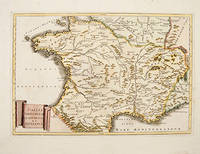
GALLIA NARBONEN SIS LUGDUNEN SIAT AQUITANEA.
de CELLARIUS, Christophorus.
- Usado
- Estado
- Usado
- Cantidad disponible
- 1
- Librería
-
London, United Kingdom
- Precio
-
EUR 112.42EUR 14.20 enviando a USA
Mostrar detalles
Descripción:
Germany., 1740. Map of pre-Roman France showing the locations of the different tribes. All place names in Latin. Copper engraving. Later colour. Excellent condition, good margins. Size: 45.5 x 30.5 cm.
Precio
EUR 112.42
EUR 14.20
enviando a USA

GAUDELOUPE. MARIE GALANTE &C. ANTIGUA.
de THOMSON, John.
- Usado
- Estado
- Usado
- Cantidad disponible
- 1
- Librería
-
London, United Kingdom
- Precio
-
EUR 443.78EUR 14.20 enviando a USA
Mostrar detalles
Descripción:
Edinburgh: , 1827. Three superb map on one sheet, of three idyllic Caribbean Islands. The New General Atlas was one of the most accurate and best produced atlases of the day. Copper engraving. Original outline colour. Some light offsetting, very good condition. Size: 60 x 50 cm.
Precio
EUR 443.78
EUR 14.20
enviando a USA

GENEVA.
de CLARKE, W.B.
- Usado
- Estado
- Usado
- Cantidad disponible
- 1
- Librería
-
London, United Kingdom
- Precio
-
EUR 230.76EUR 14.20 enviando a USA
Mostrar detalles
Descripción:
Atlas for the Society for the Diffusion of Useful Knowledge., London 1841. Crisp and detailed map of Geneva, showing harbours, streets, fortifications and major buildings. There is an inset view of the city at lower left. Title and scales at lower right Steel engraving. Original colour. Fine condition. Size: 380 x 285 mm. (15 x 11 inches)
Precio
EUR 230.76
EUR 14.20
enviando a USA

GENEVA.
de DAVIES, B.R.
- Usado
- Estado
- Usado
- Cantidad disponible
- 1
- Librería
-
London, United Kingdom
- Precio
-
EUR 230.76EUR 14.20 enviando a USA
Mostrar detalles
Descripción:
London., 1836. Crisp and detailed map of Geneva, showing harbours, streets, fortifications and major buildings. There is an inset view of the city at lower left and an inset map of the environs of the city at upper right. Title and scales at lower right. Published in 'The Atlas for the Society for the Diffusion of Useful Knowledge' by Baldwin and Cradock. Size: 380 x 285 mm. Mounted size: 550 x 485 mm. Steel engraving. Original colour. Fine condition.
Precio
EUR 230.76
EUR 14.20
enviando a USA

GERMAN STATES: 15.
de Artist: DOWER, John.Engraved by Dower, John.
- Usado
- Estado
- Usado
- Cantidad disponible
- 1
- Librería
-
London, United Kingdom
- Precio
-
EUR 88.76EUR 14.20 enviando a USA
Mostrar detalles
Descripción:
London., 1835. This map is from A New General Atlas of the World published by Henry Teesdale & Co. With coloured margins of each state. It shows cities, place names, roads, rivers, lakes, and islands Copper engraving. Original colour. Very good condition. Size: 35 x 43 cm.
Precio
EUR 88.76
EUR 14.20
enviando a USA

GERMANIA.
de QUAD, Matthias.
- Usado
- Estado
- Usado
- Cantidad disponible
- 1
- Librería
-
London, United Kingdom
- Precio
-
EUR 378.69EUR 14.20 enviando a USA
Mostrar detalles
Descripción:
Fascilus Geographicus., 1608. Handsome map of Germany with foliated border. Coat of arms, with two-headed eagle at lower left, title at top left. Matthaus Quad was a German cartographer based in Cologne, which, at the time was the centre for German cartography. This map is from his Fascilus Geographicus. It was printed by Johannes Bussemacher. Copper engraving. Original outline colour. Very good condition. Good margins. Rivers, forests and a few place-names outlined in brown and green. Size: 28.5 x 22 cm. (11 x 8½ inches).
Precio
EUR 378.69
EUR 14.20
enviando a USA

GERMANIA.
de MERCATOR/JANSSON.
- Usado
- Estado
- Usado
- Cantidad disponible
- 1
- Librería
-
London, United Kingdom
- Precio
-
EUR 142.01EUR 14.20 enviando a USA
Mostrar detalles
Descripción:
Atlas Minor. Jan Jansson., 1651, 2nd German edition.. Beautiful map of Germany from Jansson's edition of Mercator's Atlas Minor. Copper engraving. Original colour. Fine condition. Size: 19 x 14 cm. (7½ x 5½ inches). Moreland & Bannister, Antique Maps, p.98.
Precio
EUR 142.01
EUR 14.20
enviando a USA

GERMANIA: Germany.
de BOTERO, Giovanni. Engraved by Ortelius.
- Usado
- Estado
- Usado
- Cantidad disponible
- 1
- Librería
-
London, United Kingdom
- Precio
-
EUR 88.76EUR 14.20 enviando a USA
Mostrar detalles
Descripción:
RELATIONI UNIVERSALI DI GIOVANNI BOTERO BENESE., 1598. Giovanni Botero (1533-1617) was Secretary to the Duke of Savoy when he compiled his Relationi Universali; "this political and geographical description of the different countries of the world was very successful and translated into a number of languages" (Burden), including English (London 1603). Copper engraving. Uncoloured. Fine condition. map on sheet 20 x 15 cm. Map in Latin; accompanying text in Italian. Size: 11 x 8 cm. (4½ x 3 inches) Size: 11 x 8 cm. (4½ x 3 inches)
Precio
EUR 88.76
EUR 14.20
enviando a USA

GERMANY
de MOLL, Herman
- Usado
- Estado
- Usado
- Cantidad disponible
- 1
- Librería
-
London, United Kingdom
- Precio
-
EUR 142.01EUR 14.20 enviando a USA
Mostrar detalles
Descripción:
London., 1711-17. Detailed map of Germany. Clearly shows borders with surrounding countries and regions such as Austria that was part of Germany. Title at lower left. From the Atlas Geographus. Copper engraving. Later colour. Fine condition, good margins. Size: 25.8 x 17.9 cm.
Precio
EUR 142.01
EUR 14.20
enviando a USA

GERMANY (DEUTSCHLAND): Pl. 2
de WALKER, J & C.
- Usado
- Estado
- Usado
- Cantidad disponible
- 1
- Librería
-
London, United Kingdom
- Precio
-
EUR 47.34EUR 14.20 enviando a USA
Mostrar detalles
Descripción:
London., 1844. A detailed map of the eastern portion of the Prussian States. Cities include Konigsberg, Dantzig, Posen and Breslau. Published for the Society for the Diffusion of Useful Knowledge. Steel engraving. Original outline colour. Good condition. Size: 31 x 39 cm.
Precio
EUR 47.34
EUR 14.20
enviando a USA
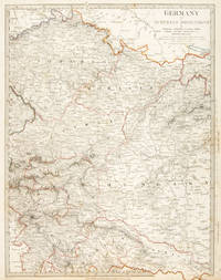
![GERMANY [In two parts].](https://d3525k1ryd2155.cloudfront.net/h/096/207/319207096.0.m.jpg)
GERMANY [In two parts].
de SMITH, Charles.
- Usado
- Estado
- Usado
- Cantidad disponible
- 1
- Librería
-
London, United Kingdom
- Precio
-
EUR 177.51EUR 14.20 enviando a USA
Mostrar detalles
Descripción:
London., 1808. Map of Germany in two parts (dimensions are of each part), north and south.From Smith's New General Atlas. The two sheets combine to make an impressive and very detailed map of Germany. Copper engraving. Original colour. Fine condition. Each sheet size: 58 x 37 cm.
Precio
EUR 177.51
EUR 14.20
enviando a USA
GERMANY IV AUSTRIAN DOMINIONS.: Pl. 4
de WALKER, J & C.
- Usado
- Estado
- Usado
- Cantidad disponible
- 1
- Librería
-
London, United Kingdom
- Precio
-
EUR 41.42EUR 14.20 enviando a USA
Mostrar detalles
Descripción:
London., 1844. A map covering the Austrian Dominions. Produced for the Society for the Diffusion of Useful Knowledge, Steel engraving. Original outline colour. Good condition. Size: 30 x 39 cm.
Precio
EUR 41.42
EUR 14.20
enviando a USA

GERMANY north of the Mayne.
de THOMSON, John
- Usado
- Estado
- Usado
- Cantidad disponible
- 1
- Librería
-
London, United Kingdom
- Precio
-
EUR 260.35EUR 14.20 enviando a USA
Mostrar detalles
Descripción:
A New General Atlas. Edinburgh: Printed by Ben Stark for John Thomson., 1827. Handsome map of northern Germany. At the time, Germany stretched from Holland to well into Poland. The New General Atlas was one of the most accurate and best produced atlases of the day. John Thomson's 'County Atlas of Scotland' is generally considered the finest of its kind. Copper engraving. Original outline colour. Fine condition. Size: 59.5 x 50 cm. (23½ x 19½ inches).
Precio
EUR 260.35
EUR 14.20
enviando a USA

GERMANY, A GENERAL MAP
de WALKER, J & C.
- Usado
- Estado
- Usado
- Cantidad disponible
- 1
- Librería
-
London, United Kingdom
- Precio
-
EUR 53.25EUR 14.20 enviando a USA
Mostrar detalles
Descripción:
London. , 1844. A simple but accurate map of Germany, produced for the Society for the Diffusion of Useful Knowledge. Steel engraving. Original outline colour. Good condition. Size: 39 x 31 cm.
Precio
EUR 53.25
EUR 14.20
enviando a USA

GERMANY Divided into CIRCLES according to Modern History.
de MOLL, Herman.
- Usado
- Estado
- Usado
- Cantidad disponible
- 1
- Librería
-
London, United Kingdom
- Precio
-
EUR 112.42EUR 14.20 enviando a USA
Mostrar detalles
Descripción:
London, 1744. Map of Germany, including modern day, Austria, Czech Republic and Slovenia, with list of distances of major cities from Vienna. Title at lower right from Salmon's Modern History. Size: 260 x 190 mm. Copper engraving. Later colouring. Excellent condition, good margins.
Precio
EUR 112.42
EUR 14.20
enviando a USA
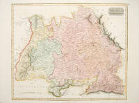
GERMANY south of the Mayne.
de THOMSON, John
- Usado
- Estado
- Usado
- Cantidad disponible
- 1
- Librería
-
London, United Kingdom
- Precio
-
EUR 260.35EUR 14.20 enviando a USA
Mostrar detalles
Descripción:
Edinburgh:, 1827. A handsome map of southern Germany, covering Baden, Bavaria and Wurtenberg. This map is from The New General Atlas. Thomson's maps were considered one of the most accurate and best produced of their day. Copper engraving. Original outline colour. Fine condition. Size: 59 x 49.5 cm.
Precio
EUR 260.35
EUR 14.20
enviando a USA

GLARONA. Glaris.
de GOTTFRIED, Johann Ludwig. Engraved by MERIAN, Matthew.
- Usado
- Estado
- Usado
- Cantidad disponible
- 1
- Librería
-
London, United Kingdom
- Precio
-
EUR 260.35EUR 14.20 enviando a USA
Mostrar detalles
Descripción:
Archontologia Cosmica., 1649. A spectacular view of the town of Glarus in east central Switzerland, entitled at the top with both its Italian name (Glarona) and its French name (Glaris). Impressively craggy mountains tower in the background with the very picturesque town laid out at their feet, a river running past in the foreground. In the centre top under the title is a coat of arms depicting a saint with a staff. Copper engraving. Uncoloured. In very good condition. Size: 290 x 280 mm. (11½ x 11 inches)
Precio
EUR 260.35
EUR 14.20
enviando a USA

GLOBE CELESTE. GLOBE TERESTRE.: Planche 37. Pag.260 and Planche 20. Pag. 145
de BION, Nicolas.
- Usado
- Estado
- Usado
- Cantidad disponible
- 1
- Librería
-
London, United Kingdom
- Precio
-
EUR 230.76EUR 14.20 enviando a USA
Mostrar detalles
Descripción:
L'Usage des Globes, celeste et terrestre et des Spheres. Paris., 1728. Attractive pair of prints showing a celestial and a terrestrial globe. Nicolas Bion was a French mathematician and maker of globes and scientific instruments. Author of two important works : L'Usage des globes celestes et terrestres, et des spheres, suivant les différents systèmes du monde [Paris 1699] and Traité de la construction et des principaux usages des instrumens de mathématiques [Paris 1709]. Both works proved highly popular and were translated into a number of other European languages. Size: 90 x 150 mm each. Copper engraving. Hand coloured. Very good condition; rusty spot outside the border of the celestial print and within the terrestrial globe.
Precio
EUR 230.76
EUR 14.20
enviando a USA

GLOBES, CONSTRUCTION MECANIQUE DES GLOBES.: Pl.2
de Engraved by BENARD.
- Usado
- Estado
- Usado
- Cantidad disponible
- 1
- Librería
-
London, United Kingdom
- Precio
-
EUR 82.84EUR 14.20 enviando a USA
Mostrar detalles
Descripción:
c.1775. Interesting print showing all the elements of a globe and its construction. Size: 185 x 240 mm. Copper engraving. Hand coloured. Fine condition.
Precio
EUR 82.84
EUR 14.20
enviando a USA

¿No has encontrado lo que estabas buscando?
Prueba a añadir esta búsqueda a búsquedas guardadas Cada día se añaden millones de libros a Biblio. Cuando uno de ellos encaje con tu búsqueda, te enviaremos un correo para avisarte. Y lo mejor de todo, ¡es gratis!
Añadir a búsquedas guardadas

¿Eres un lector habitual o un coleccionista de libros?
Únete al Biblioclub y ahorra 10% en cada compra, ¡cada día! Hasta un máximo de 20$ en cada pedido

Responsabilidad social
¿Sabías que desde 2004 Biblio ha destinado sus beneficios a la construcción de 16 bibliotecas públicas en zonas rurales de Latinoamérica?
