Ver a tamaño completo.


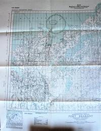
Fold-Out Topographical Survey Map. Port Brabant Northwest Territories (District of Mackenzie). Aeronautical Edition
- Usado
- Muy bueno
- Tapa blanda
- Estado
- Muy bueno
- Librería
-
Calgary, Alberta, Canada
Formas de pago aceptadas
Sobre este artículo
Ottawa: Hydrographic and Map Service., 1943 Map is scale 1 inch to 8 miles with lakes shaded in blue. Measures 27" by 24" with border. Shows: Towns, settlements, trading post, RCMP, seaplane anchorage, etc. Minor wear. Very Good.
Reseñas
(¡Iniciar sesión or Crear una cuenta primero!)
Detalles
- Librería
- Ken Jackson
 (CA)
(CA)
- Inventario del vendedor #
- 256107
- Título
- Fold-Out Topographical Survey Map. Port Brabant Northwest Territories (District of Mackenzie). Aeronautical Edition
- Formato/Encuadernación
- Soft cover
- Estado del libro
- Usado - Muy bueno
- Cantidad disponible
- 1
- Encuadernación
- Tapa blanda
- Editorial
- Hydrographic and Map Service.
- Lugar de publicación
- Ottawa
- Fecha de publicación
- 1943
- Peso
- 0.00 libras
- Palabras clave
- CARTOGRAPHY AND MAPS FOLD-OUT TOPOGRAPHICAL SURVEY MAP. PORT BRABANT NORTHWEST TERRITORIES (DISTRICT OF MACKENZIE). AERONAUTICAL EDITION MAP CANADA
- Catálogos del vendedor
- Cartography and Maps;
Términos de venta
Ken Jackson
Any book may be returned for any reason. If not as described we will pay shipping both ways.
Sobre el vendedor
Ken Jackson
Miembro de Biblio desde 2005
Calgary, Alberta
Sobre Ken Jackson
We are a family business and have been involved in books since 1971.
