Libros antiguos y raros
Libros raros de BICKERSTAFF'S BOOKS, MAPS &C.
Resultados: 1 - 15 de 23
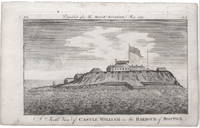
A North View of Castle William in the Harbour of Boston.
de [Boston: Castle William.] Massachusetts Magazine.
- Usado
- very good
- Estado
- Usado - Very Good
- Librería
-
Scarborough, Maine
- Precio
-
EUR 1,401.30EUR 10.00 enviando a USA
Mostrar detalles
Precio
EUR 1,401.30
EUR 10.00
enviando a USA

Más fotos
View of the British Fortress at Stoney-Point, Stormed and Carried by a party of the Light Corps of the American Army, under the command of Gen. WAYNE, on the morning of the 16th of July last.
de [American Revolution Battle Plan.] [Plan appearing in:] Bickerstaff’s Boston Almanack, for the year of our Redemption, 1780.
- Usado
- Bien
- Estado
- Usado - Good
- Librería
-
Scarborough, Maine
- Precio
-
EUR 4,203.90EUR 10.00 enviando a USA
Mostrar detalles
Precio
EUR 4,203.90
EUR 10.00
enviando a USA
Más fotos
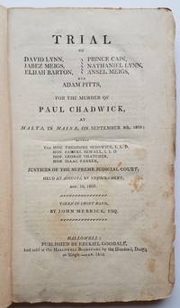
Trial of David Lynn, Jabez Meigs, Elijah Barton, Prince Cain, Nathaniel Lynn, Ansel Meigs, and Adam Pitts, for the murder of Paul Chadwick, at Malta, in Maine, on September 8th, 1809...taken in short hand by John Merrick, Esq.
de [Law.] [Early Maine Trial.]
- Usado
- Estado
- Usado - See below
- Librería
-
Scarborough, Maine
- Precio
-
EUR 1,401.30EUR 10.00 enviando a USA
Mostrar detalles
Precio
EUR 1,401.30
EUR 10.00
enviando a USA
Más fotos
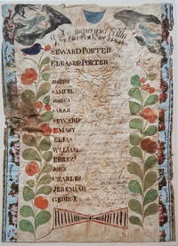
A list of names and births of Seward Porters Family.
de [Maine.] [Manuscript Family Register: Porter.]
- Usado
- fair
- Estado
- Usado - Fair
- Librería
-
Scarborough, Maine
- Precio
-
EUR 1,821.69EUR 10.00 enviando a USA
Mostrar detalles
Precio
EUR 1,821.69
EUR 10.00
enviando a USA

Más fotos
The History of the District of Maine....Illustrated by a new correct Map of the District.
de [Maine.] Sullivan, James.
- Usado
- Tapa dura
- Estado
- Usado - See below
- Encuadernación
- Hardcover
- Librería
-
Scarborough, Maine
- Precio
-
EUR 2,101.95EUR 10.00 enviando a USA
Mostrar detalles
Precio
EUR 2,101.95
EUR 10.00
enviando a USA

Más fotos
View of the ancient Buildings belonging to Harvard College, Cambridge, New-England. [included with] The Columbian Magazine for December, 1788.
de [View: Harvard College] [Magazine: Early American.]
- Usado
- Estado
- Usado
- Librería
-
Scarborough, Maine
- Precio
-
EUR 3,690.09EUR 10.00 enviando a USA
Mostrar detalles
Precio
EUR 3,690.09
EUR 10.00
enviando a USA

Más fotos
Lines on the death of Ebenezer Ball, who was executed at Castine, Oct. 31, 1811, for the murder of John Tileston Downs [i.e., Downes].
de [Execution Broadside.] Fisher, Jonathan.
- Usado
- fair
- Estado
- Usado - Fair
- Librería
-
Scarborough, Maine
- Precio
-
EUR 7,006.50EUR 10.00 enviando a USA
Mostrar detalles
Precio
EUR 7,006.50
EUR 10.00
enviando a USA

Más fotos
New York entworfen von D.F. Sotzmann.
de [New York.] Ebeling/Sotzmann.
- Usado
- Estado
- Usado
- Librería
-
Scarborough, Maine
- Precio
-
EUR 4,203.90EUR 10.00 enviando a USA
Mostrar detalles
Precio
EUR 4,203.90
EUR 10.00
enviando a USA
![[The Harbours and Rivers between Portland Point and Stage Island.]](https://d3525k1ryd2155.cloudfront.net/h/298/786/1422786298.0.m.jpg)
Más fotos
[The Harbours and Rivers between Portland Point and Stage Island.]
de [Maine: Casco Bay.] Des Barres, Joseph Frederick Wallet.
- Usado
- Estado
- Usado
- Librería
-
Scarborough, Maine
- Precio
-
EUR 7,426.89EUR 10.00 enviando a USA
Mostrar detalles
Precio
EUR 7,426.89
EUR 10.00
enviando a USA

Más fotos
View of the Federal Edifice in New York.
de [New York City View.] [U.S. Capitol.]
- Usado
- Estado
- Usado
- Librería
-
Scarborough, Maine
- Precio
-
EUR 2,101.95EUR 10.00 enviando a USA
Mostrar detalles
Precio
EUR 2,101.95
EUR 10.00
enviando a USA
Más fotos
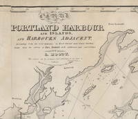
Chart of Portland Harbour and Islands, and Harbours Adjacent, Extending from the River Kennebec to Wood Island and Winter Harbour, Drawn from the Survey of Des Barres with Additions and Corrections by L. Moody.
de [Casco Bay, Maine] [Nautical Chart.] Moody, Lemuel.
- Usado
- Estado
- Usado
- Librería
-
Scarborough, Maine
- Precio
-
EUR 10,276.20EUR 10.00 enviando a USA
Mostrar detalles
Precio
EUR 10,276.20
EUR 10.00
enviando a USA

Más fotos
The Constitution of the State of Maine, and that of the United States. An Appendix Containing the Act of Separation.
de [Maine.]
- Usado
- Tapa dura
- Estado
- Usado
- Encuadernación
- Hardcover
- Librería
-
Scarborough, Maine
- Precio
-
EUR 2,242.08EUR 10.00 enviando a USA
Mostrar detalles
Precio
EUR 2,242.08
EUR 10.00
enviando a USA

Más fotos
Engineer Special Study of the Surface of the Moon
de [Lunar Mapping.] Mason, Arnold C. and Robert J. Hackman.
- Usado
- Estado
- Usado
- Librería
-
Scarborough, Maine
- Precio
-
EUR 1,401.30EUR 10.00 enviando a USA
Mostrar detalles
Precio
EUR 1,401.30
EUR 10.00
enviando a USA
![[Almanac.] More, Roger [pseudonym.] Poor Roger, 1758. The American Country Almanack, for the...](https://d3525k1ryd2155.cloudfront.net/h/439/103/1477103439.0.m.jpg)
Más fotos
[Almanac.] More, Roger [pseudonym.] Poor Roger, 1758. The American Country Almanack, for the year of Christian Account 1758. ... Calculated according to art, and fitted to the province of New-York ... By Roger More, philodespot...
de [Almanac.] More, Roger [pseudonym.]
- Usado
- Estado
- Usado
- Librería
-
Scarborough, Maine
- Precio
-
EUR 1,634.85EUR 10.00 enviando a USA
Mostrar detalles
Precio
EUR 1,634.85
EUR 10.00
enviando a USA

Más fotos
Map of Dartmouth Coll: Present & Future.
de [Dartmouth College.] [Pictorial Map.] L[arson], J[ens] F[redrick]
- Usado
- Estado
- Usado
- Librería
-
Scarborough, Maine
- Precio
-
EUR 1,401.30EUR 10.00 enviando a USA
Mostrar detalles
Precio
EUR 1,401.30
EUR 10.00
enviando a USA

