J. Sea (Nautical) Charts, Coastal Surveys from The Prime Meridian: Antique Maps & Books
Novedades

(US Coastal Survey): Preliminary Chart of Wassaw Sound Wilmington and Tybee Rivers Georgia
de Bache, A.D
- Estado
- Usado - Very Good
- Published
- 1866
- Cantidad disponible
- 1
- Librería
-
Crozet, Virginia, USA
- Precio
-
EUR 88.54
Mostrar detalles
Descripción:
Washington (DC): US Coast Survey, 1866. Very good b&w chart (thin paper) with folds as issued and very little foxing. The chart is dated 1864, but appeared in the 1866 report of the superintendent of the US Coast Survey, then Alexander Dallas Bache, great grandson of Benjamin Franklin. There are elaborate depth soundings present. Triangulation was by C.O. Boutelle, C.P.… Saber más sobre este artículo Precio
EUR 88.54
(Coastal Chart, environs of San Francisco Bay): Preliminary Chart of the Pacific Coast from Point Pinos to Bodega Head California
de Bache, A. D
- Estado
- Usado - Very Good
- Published
- 1866
- Cantidad disponible
- 1
- Librería
-
Crozet, Virginia, USA
- Precio
-
EUR 163.10
Mostrar detalles
Descripción:
Washington (DC): US Coast Survey, 1866. Very good, b&w (thin paper) chart with folds as issued, and very little foxing or browning. The image measures 97 x 70 cm. This California chart is in the vicinity of, and has depth soundings for San Francisco Bay . This chart indicates it was originally published in 1862, is the edition of 1865,… Saber más sobre este artículo Precio
EUR 163.10
(US Coast Survey Chart): Bodega Bay California
de Bache, A. D
- Estado
- Usado - Very Good
- Published
- 1866
- Cantidad disponible
- 1
- Librería
-
Crozet, Virginia, USA
- Precio
-
EUR 60.58
Mostrar detalles
Descripción:
Washington (DC): US Coast Survey, 1866. Very good, b&w with folds as issued, and very little foxing and fold browning. Bodega Bay is just north of San Francisco, and named for Spanish explorer Don Juan Francisco de la Bodega. The chart is dated 1864, but is from the 1866 report of the superintendent of the US Coast Survey, then Alexander… Saber más sobre este artículo Precio
EUR 60.58
(River Survey, US Coast Survey): Ohio River Between Mound City and Cairo
de Bache, A. D
- Estado
- Usado - Very Good
- Published
- 1866
- Cantidad disponible
- 1
- Librería
-
Crozet, Virginia, USA
- Precio
-
EUR 79.22
Mostrar detalles
Descripción:
Washington (DC): US Coast Survey, 1866. Near fine but for small extra crease right upper corner due to being folded in book. B&W, with folds as issued, on thin paper. This chart shows the mouth of the Ohio River where it joins the Mississippi, at the border region of Illinois and Kentucky. Small plans of Mound City and Cairo are… Saber más sobre este artículo Precio
EUR 79.22
(Sailing Charts, Coast Survey): Potomac River (in four sheets)
de Bache, A. D
- Estado
- Usado - Very Good
- Published
- 1866
- Cantidad disponible
- 1
- Librería
-
Crozet, Virginia, USA
- Precio
-
EUR 461.34
Mostrar detalles
Descripción:
Washington (DC): US Coast Survey, 1866. All four (thin paper) sheets, b&w with folds as issued, very good or better, with almost no browning or foxing. These are from the 1866 report of the Superintendent of the Coast Survey. Alexander Dallas Bache, then superintendent of the survey, was the great-grandson of Benjamin Franklin. These sheets are all dated 1864 on… Saber más sobre este artículo Precio
EUR 461.34
(US Coast Survey, Reconnaissance Chart): Mississippi River (sheets no. 1 and 2)
de Bache, A. D
- Estado
- Usado - Very Good
- Published
- 1866
- Cantidad disponible
- 1
- Librería
-
Crozet, Virginia, USA
- Precio
-
EUR 135.14
Mostrar detalles
Descripción:
Washington (DC): US Coast Survey, 1866. Both sheets (thin paper), very good or better, b&w with folds as issued. These were issued as part of the 1866 report of the Superintendent of the Coast Survey. Alexander Dallas Bache, then superintendent of the survey, was the great grandson of Benjamin Franklin. Both images measure approximately 52 x 41 cm. These sheets… Saber más sobre este artículo Precio
EUR 135.14
(complete 3-sheet chart set: California, Washington): Reconnaissance of the Western Coast of the United States
de Bache, A. D. [Alexander Dallas]
- Estado
- Usado
- Published
- 1866
- Cantidad disponible
- 1
- Librería
-
Crozet, Virginia, USA
- Precio
-
EUR 885.40
Mostrar detalles
Descripción:
Washington (DC): US Coast Survey, 1866. Very good, b&w, folds as issued, few foxed spots, one or two separations at folds (no images loss). These are from the 1864 Report of the Superintendent of the Coast Survey, published in 1866. The three sheets are: 1. lower sheet--San Francisco to San Diego...1853 corrected to 1864 (16 small coastal views including entrance… Saber más sobre este artículo Precio
EUR 885.40
(US Coast Survey, Massachusetts): Coast Chart No. 10 Boston Bay and Approaches
de Bache, A. D. [Alexander Dallas]
- Estado
- Usado - Very Good
- Published
- 1866
- Cantidad disponible
- 1
- Librería
-
Crozet, Virginia, USA
- Precio
-
EUR 396.10
Mostrar detalles
Descripción:
Washington (DC): US Coast Survey, 1866. Very good, thin paper, b&w as issued, folds as issued, few small wormholes to lower crease without major image loss, minimal fold browning. The area runs from Cape Ann in the northeast corner, southwestward to the mouth of Green Harbor River. Elaborate depth soundings present. Many small city/town plans in coastal environs of Boston… Saber más sobre este artículo Precio
EUR 396.10
(US Coast Survey Chart): Newport Harbor and Approaches Rhode Island...Triangulations By E. Blunt...1864
de Bache, A. D. [Alexander Dallas]
- Estado
- Usado - Near Fine
- Published
- 1866
- Cantidad disponible
- 1
- Librería
-
Crozet, Virginia, USA
- Precio
-
EUR 163.10
Mostrar detalles
Descripción:
Washington (DC): US Coast Survey, 1866. Near fine, b&w, thin paper, with folds as issued, from the 1864 Report of the Superintendent of the Coast Survey, published in 1866. Bache was a grandson of Benjamin Franklin. The image measures 42 x 32 cm (16.5 x 12. 5 inches), with many depth soundings, and tabular summaries of soundings and tides. Topography… Saber más sobre este artículo Precio
EUR 163.10
(Complete 3-Sheet chart set, US Coast Survey): Long Island Sound
de Hassler, F. R. [Ferdinand Rudolph); Bache, A. D. [Alexander Dallas]
- Estado
- Usado - Near Fine
- Edición
- Second Edition
- Published
- 1866
- Cantidad disponible
- 1
- Librería
-
Crozet, Virginia, USA
- Precio
-
EUR 1,188.30
Mostrar detalles
Descripción:
Washington (DC): US Coast Survey, 1866. Near fine set of all 3 sheets (sheets 13-15 numbered on verso), folds as issued, thin paper, almost no browning, b&w as issued, of this landmark survey of Long Island Sound. This set is from the 1855 survey, published in the 1864 Report of the Superintendent of the Coast Survey, issued in 1866 (ref:… Saber más sobre este artículo Precio
EUR 1,188.30
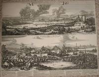
(2 Views; Second Anglo-Dutch War): Afbeeldingh van de stadt en revier van Rochester, Chetham..Aerdigh na 't leven geteeckent door W. Schellinks..zuydt-west syde, waer in klaer Vertoont..victorieuse uytwerckingh van de oorlochs vloot der ... Iunii 1667
de Schellinks, Willem and Hooghe, Romeyn De
- Estado
- Usado
- Edición
- First Edition Thus
- Published
- 1667
- Cantidad disponible
- 1
- Librería
-
Crozet, Virginia, USA
- Precio
-
EUR 1,817.40
Mostrar detalles
Descripción:
Amsterdam: I(oshue) Ottens, 1667. A more complete title for this copper-plate etching with two views is: Afbeeldingh van de stadt en revier van Rochester, Chetham, etc. Aerdigh na 't leven geteeckent door W. Schellinks van de zuydt-west syde, waer in klaer vertoont wert de victorieuse uytwerckingh van de oorlochs vloot der ... Staten Generael ... voorgevallen op den 19, 20,… Saber más sobre este artículo Precio
EUR 1,817.40
(1870 Facsimile of 1775 Des Barres): A chart of the Harbour [harbor] of Boston, composed from different surveys, but principally from that taken in 1769, by Mr George Callender, late Master of His Majesty's ship Romney
de Meisel, A. (Des Barres, JFW)
- Estado
- Usado - Very Good
- Edición
- First Edition Thus
- Published
- 1870
- Cantidad disponible
- 1
- Librería
-
Crozet, Virginia, USA
- Precio
-
EUR 1,840.70
Mostrar detalles
Descripción:
Boston: A. Meisel, Lith., 1870. VG, with folds as issued, thin paper, some fold browning, a couple of small spot separations at fold junctures with no significant image loss. This is a full sized (73 x 101 cm) lighographic facsimile (reproduction) image of the Des Barres harbor chart. The sailing directions are not present, as with HNS (Henry Newton Stevens)… Saber más sobre este artículo Precio
EUR 1,840.70
(US Coast Survey-- Virginia): (C No. 4) Preliminary Chart of James River Virginia From Richmond to City Point Including the Appomattox River From Petersburg to the Junction
de Bache, AD (Superintendent)
- Estado
- Usado
- Published
- 1856
- Cantidad disponible
- 1
- Librería
-
Crozet, Virginia, USA
- Precio
-
EUR 135.14
Mostrar detalles
Descripción:
Washington (DC): Cornellius Wendell (Printers), 1856. B&W, VG w/minimal fold browning. Includes description of sandbars in Appomattox River. From the "Report of the Superintendent of the Coast Survey, Showing the Progress of the Survey During the Year 1855." 66x75cm.. Precio
EUR 135.14
(Map/ Sea Chart of English Channel): A Reference Chart of the English Channel Compiled By Lieutenant Hughes C. Lockyer...1899. Shewing the Principal Sea Lights and Buoys, Generl Topography...Outlying Dangers on the English Coast
de Lockyer, Hughes C. (Stanford)
- Estado
- Usado
- Published
- 1901
- Cantidad disponible
- 1
- Librería
-
Crozet, Virginia, USA
- Precio
-
EUR 274.94
Mostrar detalles
Descripción:
London: Edward Stanford, 1901. VG+ 40 panel linen backed chart, quite striking, with original color. A single right sided fold separation (in an area of text) has been repaired verso with clear archival tape. Channel Islands clearly shown. The updates to 1901 are on printed sheets attached to verso, per the publisher. The case for this folding chart is in… Saber más sobre este artículo Precio
EUR 274.94
(Schooner Route Map; Canada): Outline Chart Showing the Track of the U.S.F. C. Schr. Grampus on the Cruise to Newfoundland, Labrador and Gulf of St. Lawrence. 1887
de United States Commission of Fish and Fisheries (M. McDonald, Commissioner)
- Estado
- Usado
- Published
- 1891
- Cantidad disponible
- 1
- Librería
-
Crozet, Virginia, USA
- Precio
-
EUR 111.84
Mostrar detalles
Descripción:
US Government Printing Office, 1891. B&W as issued, map bound into book in 2 parts, divided midway east-west (i.e. north and south map segments). If sheets were joined, the full image would measure 18.5x26 inches. This is a rather detailed route map for this ship, issued in conjunction with the fisheries report, with Nova Scotia, Sable Island, Bay of Fundy,… Saber más sobre este artículo Precio
EUR 111.84
(US Coast Survey-- Florida): (G No. 2) Preliminary Chart of Cedar Keys and Approaches, Florida
de Bache, AD (Superintendent)
- Estado
- Usado
- Cantidad disponible
- 1
- Librería
-
Crozet, Virginia, USA
- Precio
-
EUR 46.60
Mostrar detalles
Descripción:
Beverley Tucker Public Printer, Washington (DC), 1855. B&W, VG w/minimal browning. Elaborate depth soundings and area of "Main Ship Channel" are indicated. Also extends out to Snake and Sea Horse Keys. From the "Report of the Superintendent of the Coast Survey, Showing the Progress of the Survey During the Year 1854." 59x46cm.. Precio
EUR 46.60
(Blue-Back Chart of England / Ireland): The Irish or St. George's Channel Compiled from the Most Recent Surveys
de Imray, James (and Son)
- Estado
- Usado
- Published
- 1876
- Cantidad disponible
- 1
- Librería
-
Crozet, Virginia, USA
- Precio
-
EUR 489.30
Mostrar detalles
Descripción:
London: James Imray & Son (89 & 102 Minories), 1876. Enormous rolled blue-back chart from this prominent publisher. This is oriented more west to east, given the configuration of the Irish Channel (St. George's Channel). As always, loaded with detail. Generally very good, with 1 small tear mid channel, not seriously affecting image. Details include elaborate depth soundings throughout, the… Saber más sobre este artículo Precio
EUR 489.30
(Map of Mexico): Chart of the Harbour of Vera Cruz
de Blunt, Edmund M
- Estado
- Usado
- Published
- 1827
- Cantidad disponible
- 1
- Librería
-
Crozet, Virginia, USA
- Precio
-
EUR 65.24
Mostrar detalles
Descripción:
Edmund and George W. Blunt, NY (54 Water-Street, Corner of Maiden-Lane), 1827. B&W, G due to some browning and staining with mild foxing. Image is reasonably clear, with the Reef of the Gallician, Island of Sacrifices, Green Island, Whitish Island shown. The river and bay of Vergara is indicated, along with a larger depiction of the city of Veracruz. From… Saber más sobre este artículo Precio
EUR 65.24
(Military Maritime History - 50 plates): Marine Militaire Ou Recueil Des Differens Vaisseax Qui Servent a la Guerre, Suivis Des Manoeuvres...au Combat...la Defense Des Portes...
de Ozanne [Nicolas (-Marie)]
- Estado
- Usado - Very Good
- Published
- 1762
- Cantidad disponible
- 1
- Librería
-
Crozet, Virginia, USA
- Precio
-
EUR 1,211.60
Mostrar detalles
Descripción:
Paris: Chez L'Auteur (Ozanne; Rue St. Thomas du Louvre), 1762. Large 8vo, later vellum spine with cloth boards, complete with all 50 engraved, b&w, numbered plates (some are actually text, in French), plus the engraved title and dedication (Le Duc De Choiseui) pages. Endpapers intact, with very little browning and foxing, with heavy laid paper. There are some very small… Saber más sobre este artículo Precio
EUR 1,211.60
(Map/ Chart of Virginia): Preliminary Chart of Hampton Roads and Elizabeth River Virginia
de Bache, A. D
- Estado
- Usado
- Published
- 1858
- Cantidad disponible
- 1
- Librería
-
Crozet, Virginia, USA
- Precio
-
EUR 116.50
Mostrar detalles
Descripción:
Washington DC: James Steedman, Printer, 1858. VG, b&w as issued, folds as issued, with fragile crease folds (few early separations). Moderatley detailed chart of Hampton Roads environs, with Willoughby's Bay and Craney Island Flats.This is from the 1857 (published 1858) "Report of the Superintendent of the Coast Survey, Showing the Progress of the Survey in the Year 1857". The… Saber más sobre este artículo Precio
EUR 116.50
